-
 Remnants of the abandoned railroad tracks and switch near the trailhead in Munster
 -
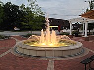 The Monon Trailhead in downtown Munster was built in 2012.
 -
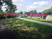
 The 1909 railroad bridge over the Little Calumet River was rebuilt in 2014 as a trail bridge.
 -
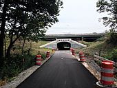
 View of the Monon Trail looking south from the bridge over 165th St. in Hammond
| Monon Trail | |
|---|---|
|
The Monon Trail utilizes the same logo and design cues throughout the entire trail. | |
| Length | 4.4 mi (7.1 km) (Northwest Indiana) 24 mi (39 km) (Indianapolis) |
| Location | Lake, Hamilton, Marion counties, Indiana |
| Established | 1996-present (in segments) |
| Designation | |
| Trailheads |
Munster—
Hammond Indianapolis— Sheridan |
| Use | Shared use path |
| Season | Year-round |
| Surface |
Asphalt Compacted stone (north of 161st St. in Westfield) |
| Right of way | Monon Railroad |
| Website |
Northwest Indiana segment Indianapolis segment |
| Trail map | |
|
Indianapolis area extent of the trail | |
The Monon Trail (known as the Monon Greenway in Carmel) is a rail trail located entirely within the state of Indiana. The Monon Railroad was a popular railroad line connecting the cities of Chicago and Indianapolis, with stops at major settlements along its route. After the decline of railroad travel and the sale of the company in 1987, [2] the portion of the line between Indianapolis and Delphi, Indiana, was abandoned. [3] [4]
In Northwest Indiana, the trail is 4.4 miles (7.1 km) long, running through Lake County from Munster to Hammond. In the Indianapolis area, the trail consists of 18.1 miles (29.1 km) running through Hamilton and Marion counties, connecting Indianapolis, Carmel and Westfield. The trail has been extended to Sheridan, making the total length 24 miles (39 km). [5]
The first portions of the trail were created in the late 1990s, but it has been consistently extended in both of its segments since then. The trail is a shared use path complete with trailheads, park amenities and local attractions near it. [6] [7]
Northwest Indiana segment
Northwest Indiana's portion of the Monon covers 4.4 miles (7.1 km), starting at the Pennsy Greenway near the Illinois–Indiana border in Munster, and running north to the Erie Lackawanna Trailhead in downtown Hammond. [6]
In 2014, the trail was significantly extended, with a segment opening between Munster and Hammond. [8] The segment connected a previously existing portion of the Monon Trail located entirely within Munster. The extension required the reconstruction of the old 1909 railroad bridge across the Little Calumet River, at a cost of approximately $1.5 million. [9]
The Northern Indiana Commuter Transportation District, which operates the South Shore commuter rail service, is reconstructing a portion of the rail route along the old Monon right-of-way. The West Lake Corridor project was planned to provide service from southern Lake County communities to and from downtown Chicago; it is estimated to be completed in 2025. [10]
Portions of the Monon Trail in Lake County


Indianapolis segment

The Monon Trail in the Indianapolis area runs northward starting from just north of downtown Indianapolis, passing through Martindale's Hillside neighborhood, the King Park, Mapleton-Fall Creek, Meridian-Kessler, Broad Ripple, and Nora neighborhoods, and then proceeding into Carmel and Westfield, Indiana, a length of 18.1 miles (29.1 km). Plans to create a shared use trail on the former Monon right-of-way date back to the late 1980s. [11] In 1999, a 10.0-mile (16.1 km) segment in Indianapolis was completed, while a 5.2-mile (8.4 km) segment in Carmel was opened between 2001 and 2002. [12] The first phase of the trail cost approximately $5.5 million to create. [13]
The trail was extended into Westfield starting in the fall of 2008, and since then has been extended north over the abandoned Monon right of way toward Sheridan, Indiana, for a total of 2.9 miles (4.7 km) in Westfield. [14] In Indianapolis the Monon connects with the Central Canal Towpath along the Indiana Central Canal, and the Fall Creek Greenway. [7] In Westfield, the trail provides access to the Midland Trace, Anna Kendall, and the Little Eagle Creek trails. [15]
In the Indianapolis area, the Monon Trail is used by more than 1.3 million people annually. [16] [17] The trail has been cited as having a positive economic impact to neighborhoods adjacent to the trail, including Broad Ripple in Indianapolis and the mixed-use developments of downtown Carmel, which have experienced a large growth in population over the past decade. [18] [19] [20] [21]
The longest continuous stretch begins in Indianapolis at 10th street, and runs North, terminating in Grand Park of Westfield at 191st street. This continuous stretch is 20.6 miles (33.2 km). After reaching Grand Park, bikers can take country roads to reconnect with the trail at 216th street, where the trail picks back up and goes another 3.1 miles (5.0 km) and ending in Sheridan. The final connection from 191st Street to 216th Street was completed in 2020. [22][ needs update]
Visitor attractions along the trail:
Portions of the Monon Trail in Marion and Hamilton Counties
-
 An original Monon Railroad bridge was repurposed as a trail overpass in Indianapolis.
 -
 The trail traverses Indianapolis's north side neighborhoods.
 -
 A mixed-use development in downtown Carmel surrounds the Monon Greenway.
 -
 North of Carmel, the greenway passes under U.S. Route 31 heading towards Westfield.
 -
 An overpass was created in Carmel's section of the greenway, spanning 146th St.
 -
 A bridge over East 176th Street in Westfield, opened in May 2020.
 -
 Plaza near the Indiana School for the Deaf and 42nd Street in Indianapolis.


References
- ^ "USBR#35". Indiana Trails. Greenways Foundation. Retrieved November 23, 2015.
- ^ "Monon Corp. sold to investor group of Monon executives". The Indianapolis Star. Indiana State Library. January 5, 1987. Retrieved November 19, 2015.
- ^ Kinlock, Ken. "The Monon Railroad". kinglyheirs.com. Retrieved November 19, 2015.
- ^ "Track in Indianapolis is being dismantled but effort continues to save other sections". The Indianapolis Star. Indiana State Library. December 17, 1986. Retrieved November 19, 2015.
- ^ Contreras, Natalia E. (October 16, 2018). "'We can make it Indiana's trail': Monon now runs 24 miles, from Indy to Sheridan". Indianapolis Star. Retrieved November 3, 2020.
- ^ a b "Monon Trail (Lake County)". TrailLink. Rails-to-Trails Conservancy. Retrieved November 18, 2015.
- ^ a b "Monon Trail – Indianapolis". Indiana Trails Community. Retrieved November 18, 2015.
- ^ Ortiz, Anna (July 23, 2014). "New bike trail leg bridges Munster, Hammond". The Times of Northwest Indiana. Retrieved November 18, 2015.
- ^ Earnshaw, Rob (July 7, 2014). "Hammond opens bike, pedestrian bridges". The Times of Northwest Indiana. Retrieved November 19, 2015.
- ^ Carden, Dan. "West Lake commuter rail line construction could begin in October". NWI Times. Retrieved July 18, 2020.
- ^ "Residents want Monon corridor to be bought by city, made into recreational area-bicycling, hiking, running, etc". The Indianapolis Star. Indiana State Library. February 19, 1988. Retrieved November 19, 2015.
- ^ Sunkel, Gwen (March 22, 2014). "In The Park: The Monon Rail-Trail". Historic Indianapolis.com. Retrieved November 18, 2015.
- ^ Price, Nelson (2004). Indianapolis Then & Now. San Diego, California: Thunder Bay Press. p. 131. ISBN 1-59223-208-6.
- ^ "Monon Greenway - Carmel". Indiana Trails. Greenways Foundation. Retrieved September 8, 2011.
- ^ "Touring the trail: Monon Trail advocate, Alyn Bernell, takes ride through a portion of the Monon named after him". Current in Westfield. October 27, 2015. Retrieved November 18, 2015.
- ^ "Indiana's Monon Trail". Rails-To-Trails Conservancy. March 1, 2009. Retrieved November 18, 2015.
- ^ "Monon Trail". City of Indianapolis and Marion County.
- ^ Earnshaw, Rob (July 21, 2014). "Neighborhood conditions impact quality of life". The Times of Northwest Indiana. Retrieved November 19, 2015.
- ^ "The Economic Benefits of Open Space, Recreation Facilities and Walkable Community Design" (PDF). American Trails.org. Active Living Research. May 2010. p. 4. Retrieved November 19, 2015.
- ^ Flusche, Darren (July 2012). "Bicycling Means Business: The Economic Benefits of Bicycle Infrastructure" (PDF). Advocacy Advance. p. 23. Retrieved November 19, 2015.
- ^ "National Road Heritage Trail Development Guide" (PDF). City of Indianapolis and Marion County. Indiana Office of Tourism Development. pp. 1–2. Retrieved November 19, 2015.
- ^ "Monon Trail". City of Westfield, Indiana.
- ^ a b "Monon Trail Itinerary". Trail Link. Rails-to-Trails Conservancy. Retrieved November 19, 2015.
External links
Wikimedia Commons has media related to
Monon Railroad.
- Maps
- "Monon Trail Map (up to 96th St.)" (PDF). Greenways Foundation.[ dead link]
- "Monon Greenway Map (96th St. to 146th St.)". Carmel · Clay Parks & Recreation.[ dead link]
- Official websites
- Bike the Monon
- "Monon Trail". City of Indianapolis and Marion County.[ dead link]
- "Monon Trail". City of Westfield, Indiana.
- Video overview
Categories:
- Rail trails in Indiana
- Bike paths in the Chicago metropolitan area
- Tourist attractions in Indianapolis
- Protected areas of Hamilton County, Indiana
- Protected areas of Marion County, Indiana
- Protected areas of Lake County, Indiana
- Transportation in Hamilton County, Indiana
- Transportation in Indianapolis
- Transportation in Lake County, Indiana
- 1996 establishments in Indiana
- National Recreation Trails in Indiana