Eskişehir Province
Eskişehir ili | |
|---|---|
 Location of the province within Turkey | |
| Country | Turkey |
| Seat | Eskişehir |
| Government | |
| • Mayor | Ayşe Ünlüce ( CHP) |
| • Vali | Hüseyin Aksoy |
| Area | 13,960 km2 (5,390 sq mi) |
| Population (2022)
[1] | 906,617 |
| • Density | 65/km2 (170/sq mi) |
| Time zone | UTC+3 ( TRT) |
| Area code | 0222 |
| Website |
www www |
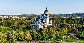
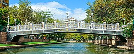
Eskişehir Province ( Turkish: Eskişehir ili) is a province and metropolitan municipality in northwestern Turkey. Its area is 13,960 km2, [2] and its population is 906,617 (2022). [1] Its adjacent provinces are Bilecik to the northwest, Kütahya to the west, Afyon to the southwest, Konya to the south, Ankara to the east, and Bolu to the north. The provincial capital is Eskişehir. Most of the province is laid down in Central Anatolia Region. Northern parts of Mihalıççık district and ones of Mihalgazi and Sarıcakaya are located in the Black Sea Region and one of them belong to the Aegean Region.
Eskişehir is an old, culturally developed province of Turkey. Eskişehir has 2 universities, Eskişehir Osmangazi University and Anadolu University, which is the largest university in Turkey and which has some branch offices in Europe.
Geography
Eskişehir has a cold semi-arid steppe climate (BSk) according to Köppen climate classification. It features warm to hot dry summers and cold to freezing winters.
Districts


Eskişehir Province is divided into 14 districts:
Demographics

Eskişehir's population has a high literacy level of 99%. Many universities and military installations are located in and around the city. Turkish technical students are concentrated in the Eskişehir universities. Infrastructural problems have been partially solved in 2004 with the construction of a tram system.
Eskisehir, and neighboring cities were the major settlement area for the descendants of the founders of the Ottoman Empire, about 1000 years ago. Many villages in the province carry the names of the Turkish tribes/clans from those times. Some people in the city of Eskişehir trace their family origin back to Crimea and the Caucasus. There are also descendants of Turkish immigrants from the Balkans fleeing war and persecution.
| Year | Pop. | ±% p.a. |
|---|---|---|
| 1927 | 154,195 | — |
| 1940 | 206,794 | +2.28% |
| 1950 | 276,164 | +2.93% |
| 1960 | 368,827 | +2.94% |
| 1970 | 459,367 | +2.22% |
| 1980 | 543,802 | +1.70% |
| 1990 | 641,057 | +1.66% |
| 2000 | 706,009 | +0.97% |
| 2010 | 764,584 | +0.80% |
| 2018 | 871,187 | +1.64% |
| source: [4] [5] | ||
Meerschaum
Eskişehir is internationally known as the source of Meerschaum, a white foamy stone which is used for smoking pipes with detailed carvings. It is called lületaşı in Turkish.
Archaeological discoveries
In August 2019, researchers head by Prof. Murat Türkteki announced the discovery of two skeletons dating back about 5,000 years in the same sarcophagus in Early Bronze Age settlement Küllüoba. Excavators assumed that one of the skeletons was a 13-year-old girl and other was a man in his late 30s. [6] [7] [8]
In August 2020, archaeologists head by Prof. Murat Türktaki revealed a 5,000-year-old paint palette made of stone in the Seyitgazi district at the Küllüoba site. According to Türktaki, this palette was used for painting dishes. [9] [10]
In March 2021, discovery of the marble sarcophagus which is 1.5 meters tall and 33 centimeters wide in the Seyitgazi district at the Küllüoba site was announced by the municipal workers while construction work. [11] [12] [13]
See also
References
- ^ a b "Address-based population registration system (ADNKS) results dated 31 December 2022, Favorite Reports" (XLS). TÜİK. Retrieved 19 September 2023.
- ^ "İl ve İlçe Yüz ölçümleri". General Directorate of Mapping. Retrieved 19 September 2023.
- ^ "Present and future Köppen-Geiger climate classification maps at 1-km resolution". Nature Scientific Data. DOI: 10.1038/sdata.2018.214.
- ^ Genel Nüfus Sayımları
- ^ tuik
- ^ sabah, daily (2019-08-04). "5,000-year-old human skeletons unearthed in central Turkey". Daily Sabah. Retrieved 2021-03-03.
- ^ "5,000-year-old double burial unearthed in central Turkey". The Archaeology News Network. Archived from the original on 2019-08-07. Retrieved 2021-03-03.
- ^ "5,000-year-old human skeletons unearthed in central Turkey". anews. Retrieved 2021-03-03.
- ^ SABAH, DAILY (2020-08-26). "5,000-year-old paint palette unearthed in northwest Turkey". Daily Sabah. Retrieved 2021-03-03.
- ^ "5,000-year-old paint palette unearthed in northwest Turkey". The Archaeology News Network. Archived from the original on 2021-06-12. Retrieved 2021-03-03.
- ^ AA, DAILY SABAH WITH (2021-03-01). "Construction workers discover ancient sarcophagus in NW Turkey". Daily Sabah. Retrieved 2021-03-03.
- ^ "Строители нашли загадочный древний саркофаг в Турции". www.mk.ru (in Russian). Retrieved 2021-03-03.
- ^ "Builders find mysterious ancient sarcophagus in Turkey - Around World journal". Retrieved 2021-03-03.
External links
- (in Turkish) Eskişehir governor's official website
- (in Turkish) Eskişehir municipality's official website


