Aksaray Province
Aksaray ili | |
|---|---|
 | |
 Location of the province within Turkey | |
| Country | Turkey |
| Seat | Aksaray |
| Government | |
| • Governor | Mehmet Ali Kumbuzoğlu |
| Area | 7,659 km2 (2,957 sq mi) |
| Population (2022)
[1] | 433,055 |
| • Density | 57/km2 (150/sq mi) |
| Time zone | UTC+3 ( TRT) |
| Area code | 0382 |
| Website |
www |
Aksaray Province ( Turkish: Aksaray ili) is a province in central Turkey. Its adjacent provinces are Konya along the west and south, Ankara to the northwest, Niğde to the southeast, Nevşehir to the east, and Kırşehir to the north. Its area is 7,659 km2, [2] and its population is 433,055 (2022). [1] The provincial capital is the city of Aksaray.
Aksaray is one of the four provinces in Cappadocia, along with Nevşehir, Niğde, and Kayseri. Also, the 3,000-metre (9,843 ft) volcano Mount Hasan stands between Aksaray and Niğde. Summers are hot and dry on the plain, but the area is green and covered in flowers in springtime, when water streams off the mountainside. The 2,400 m2 salt lake (0.59 acres), Tuz Gölü, lies within the boundaries of Aksaray, a large swamp area with a maximum depth of 1 metre (3 ft 3 in).
Districts
Aksaray province is divided into 8 districts (capital district in bold):
Etymology
In antiquity the area was named Archelais Garsaura, which was mutated to Taksara during the Seljuk Turkish era, and then to Aksaray. Aksaray means "White Palace" in Turkish.
Population
| Year | Pop. | ±% p.a. |
|---|---|---|
| 1927 | 127,031 | — |
| 1990 | 326,399 | +1.51% |
| 2000 | 396,084 | +1.95% |
| 2010 | 377,505 | −0.48% |
| 2020 | 423,011 | +1.14% |
| Source:Turkstat [3] [4] | ||
History

The plains of central Anatolia have been settled for 8,000 years, and the area around Aksaray bears monuments to a string of civilisations that have settled on the plain in that time. The mound of Aşıklı Höyük in the town of Kızılkaya indicates a settlement dating back to 5,000BC (and also a skull of a woman who had apparently been trepanned, the earliest known record of brain surgery).
Later the Silk Road came through here so caravanserai and then larger and larger settlements were built to supply and shelter travellers and traders. The city and surroundings of Aksaray thrived in the Roman, Byzantine and the Turkish periods.

Today Aksaray is a rural, agricultural province, its people religious and conservative.[ citation needed] Since the 1950s, many have moved to Europe as migrant workers. The population of Aksaray has long included a higher proportion of Kurdish people than most central Anatolian provinces. Many were resettled here from Tunceli, Diyarbakir, Adiyaman. and other eastern cities following the Sheikh Said rebellion in the 1920s. [5]
See also
Gallery
-

-
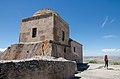 St. Analipsis Church, also known as the "High Church".
 -
-
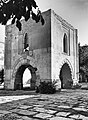
 Çanlı Kilise, meaning 'Bell Church' southwest of Aksaray city.
 -
 A view of Ihlara valley, Aksaray
 -
 View of Ihlara town
 -
 Panoramic view towards Güzelyurt Monastery Valley and Church Mosque.
 -
 Monumental entrance of the Sultan Han
 -
 Interior of the Sultan Han Caravanserai
 -
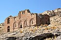
 Selime Cathedral
 -
 Ulu Mosque, also known as The Aksaray Grand Mosque.
 -
 Aşıklı Höyük - a Neolithic settlement
 -
 Alayhan Caravanserai
 -
 Tepesi Delik Han Caravanserai, Aksaray Province
_01.jpg)


.jpg)


References
- ^ a b "Address-based population registration system (ADNKS) results dated 31 December 2022, Favorite Reports" (XLS). TÜİK. Retrieved 19 September 2023.
- ^ "İl ve İlçe Yüz ölçümleri". General Directorate of Mapping. Retrieved 19 September 2023.
- ^ "Census Results". Turkstat. Archived from the original on 2016-08-02. Retrieved 22 January 2021.
- ^ "Online library of Turkstat". Turkstat. Archived from the original on 2014-06-02. Retrieved 22 January 2021.
- ^ "TÜRK OTAĞI || Türkçüler ve Türkçülük". Archived from the original on 2007-05-03. Retrieved 2006-12-13.
External links
- Aksaray governor's official website
- (in Turkish) Aksaray municipality's official website
- High resolution pictures of the city Archived 2012-08-06 at the Wayback Machine
- (in Turkish) Aksaray University student websites
Notes
This article needs additional citations for
verification. (December 2022) |
| Districts |   | ||||||||||||||||||||||||||
|---|---|---|---|---|---|---|---|---|---|---|---|---|---|---|---|---|---|---|---|---|---|---|---|---|---|---|---|
| |||||||||||||||||||||||||||
Metropolitan municipalities are bolded. | |||||||||||||||||||||||||||
| International | |
|---|---|
| National | |
| Geographic | |