This article needs attention from an expert in Palestine. Please add a reason or a talk parameter to this template to explain the issue with the article. (May 2024) |
Zoroub Hill
تل زروب (
Arabic) Tel Zarub, Tel Rafah | |
|---|---|

Survey of Palestine, British Mandate, 1942. | |
| Grid position | Palestine grid 629/1251 |
| Location | Rafah, Gaza Strip |
| Native name | تل زروب ( Arabic) |
| Elevation | 39 m (129 ft) |
Zoroub Hill (also known as Zurub hilltop) [1] is the highest point in the Gaza Strip which directly overlooks the Philadelphi Corridor and the border with Egypt. It is located on the north-west outskirts of Rafah some 2.5 kilometres (1.6 mi) north-west from the central al-Ada roundabout. [2] A strategic height at 39 metres (128 ft), Zoroub Hill was captured by IDF tanks on 28 May 2024 during the Israeli invasion of the Gaza Strip (2023–present) after a brief gun battle with Hamas. [3] [4] Its modern name derives from the relatively rare Arabic personal name Zorab, meaning to grieve, or to shed tears. [5]
Gallery
-
 Zoroub Hill, immediately south of three wastewater treatment ponds, west of the Ibn Sina terminus and ENE of an Egyptian observation post. (Click to enlarge.)
 -
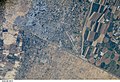 Rafah, Gaza Strip, Palestine is to the northwest, Rafah, Egypt to the south, and Israel to the east. (Click to enlarge.)


References
- ^ Sedghi, Amy; Bayer, Lili (29 May 2024). "srael-Gaza war: Turkey's Erdoğan says 'spirit of UN dead in Gaza' – as it happened". The Guardian. Retrieved 29 May 2024.
- ^ "Gaza war: Israeli tanks push into central Rafah - witnesses". www.bbc.com.
- ^ "Rafah latest: Israeli tanks in the heart of Rafah as 21 reported killed in latest strikes". BBC News. 28 May 2024.
- ^ Dr. Renee Levant [@ReneeLevant] (May 28, 2024). "Lots are reporting attacks around Zaroub Hill" ( Tweet). Retrieved 29 May 2024 – via Twitter.
- ^ "Find out the origin of the surname zoroub". nomorigine.com. Leenkus Technologies Inc.
See also
|
| This geography of the State of Palestine article is a stub. You can help Wikipedia by expanding it. |