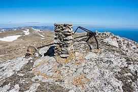
| Zeytin-Kosh | |
|---|---|
 Top of Zeytin-Kosh | |
| Highest point | |
| Elevation | 1,537 m (5,043 ft) [1] |
| Listing | |
| Coordinates | 44°37′04″N 34°16′58″E / 44.61778°N 34.28278°E |
| Geography | |
| Country | Disputed: |
| Parent range | Crimean Mountains |
Zeytin-Kosh [a] is a mountain in Crimea and the third highest mountain in the Crimean Mountains. [2] Its height stands at 1,537 metres (5,043 ft) above sea level.
Etymology
The name of the mountain is of Crimean Tatar origin and literally means "olive kosh" (zeytün or in the southern coast dialect zeytin - "olive, olive tree"; qoş - "koshara, sheepfold"). [3] [4]
Notes
- ^ Ukrainian: Зейтін-Кош, Russian: Зейтин-Кош, Crimean Tatar: Zeytin Qoş
References
- ^ "Topographic map of Zeytin-Kosh". opentopomap.org. Retrieved 2024-02-11.
- ^ "Краткая геополитическая характеристика АРК" (in Ukrainian). Главное управление статистики в Автономной Республике Крым. Archived from the original on 2013-07-10. Retrieved 2013-05-12.
- ^ Сост. С. М. Усеинов (2008). Крымскотатарско-русско-украинский словарь (in Russian). Симферополь: Тезис. pp. 182, 295. ISBN 978-966-470-005-1.
- ^ "Топонимический словарь Крыма". kimmeria.com (in Russian). Archived from the original on 2014-03-23. Retrieved 2013-05-11.
