This article needs additional citations for
verification. (July 2009) |
| Zambales Mountains | |
|---|---|
| Western Cordillera | |
 Zambales Mountain Range view from
San Narciso, Zambales | |
| Highest point | |
| Peak | Mount Tapulao (aka High Peak), Zambales |
| Elevation | 2,037 m (6,683 ft) |
| Coordinates | 15°28′51″N 120°7′16″E / 15.48083°N 120.12111°E |
| Dimensions | |
| Length | 180 km (110 mi) N-S |
| Geography | |
 Zambales Mountains topographic map
| |
| Country | Philippines |
| Provinces | Zambales, Pangasinan, Bataan, Tarlac and Pampanga |
| Region | Central Luzon & Ilocos Region |
| Range coordinates | 15°41′N 120°05′E / 15.683°N 120.083°E |
The Zambales Mountains is a mountain range on western Luzon island in the Philippines. The mountains spread along a north-south axis, separating Luzon's central plain from the South China Sea. The range extends into five provinces: Zambales, Pangasinan, Tarlac, Pampanga, and Bataan. One of its most prominent sections is known as the Cabusilan Mountain Range composed of Mount Pinatubo, Mount Negron and Mount Cuadrado, which are believed to be remnants of the ancestral Pinatubo peak. The highest elevation in the Zambales Mountains is Mount Tapulao, also known as High Peak, in Zambales province which rises to 2,037 metres (6,683 ft).
Extent
The Zambales Mountains has an area of 300 square kilometres (120 sq mi) [1] extending North to South from the mountains of western Pangasinan province, the whole length of Zambales, to tip of the Bataan Peninsula in the south enclosing Manila Bay. [2] The mountain range also encompasses the mountains in the municipalities of Bamban, Capas, San Jose, San Clemente, Mayantoc, Santa Ignacia, Camiling in the province of Tarlac. In Pampanga, it includes the mountains in Floridablanca, Porac, Lubao, Angeles City and Mabalacat.
Geology
The Zambales Mountains include Jurassic to Miocene ophiolite massifs, overlain by more recent sedimentary formation, including the Cagaluan Formation and the Santa Cruz Formation. [3]
Volcanoes
Although the mountains are volcanic in origin, [2] Mount Pinatubo is the only active volcano in the mountain range. Its eruption on June 15, 1991 was the second most powerful volcanic eruption of the 20th century after the 1912 eruption of Novarupta in Alaska. The volcanic eruption, which was complicated by the arrival of Typhoon Yunya, covered the region with thick volcanic ash and lahar including the U.S. military base at Clark Field near Angeles City.
Other volcanoes in Zambales Mountains are Mount Mariveles, Mount Natib and Mount Samat.
Protected areas
Peaks
Zambales Mountains list of highest peaks by elevation
- Mount Tapulao 6,683 ft (2,037 m)
- Mount Iba 5,430 ft (1,655 m)
- Mount Negron 5,194 ft (1,583 m)
- Mount Pinatubo 4,875 ft (1,486 m)
- Mount Mariveles 4,554 ft (1,388 m)
- Mount Cuadrado 4,344 ft (1,324 m)
- Mount McDonald 4,334 ft (1,321 m)
- Mount Natib 4,111 ft (1,253 m)
- Mount Limay 2,984 ft (910 m)
- Mount Dorst 2,785 ft (849 m)
- Mount Samat 1,788 ft (545 m)
- Mount Gates 1,663 ft (507 m)
River system
List of rivers in Zambales Mountains by length.
- Tarlac River 95.2 km (59.2 mi)
- Camiling River 93 km (58 mi)
- Pasig–Potrero River 75 km (47 mi)
- Bucao River 48.3 km (30.0 mi)
- Santo Tomas River 46.4 km (28.8 mi)
Gallery
-
 Zambales Mountain Range
 -
 View of the range from Mt. Tapulao summit
 -
 Mountainous landscape around the Camiling River watershed, Tarlac province
 -
 Upper Lawis River watershed
 -
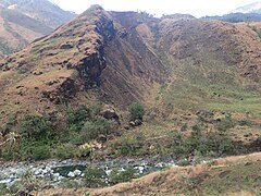
 Jagged ridge in the upper Lawis River area
 -
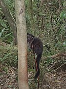 A trapped civet in the Zambales Mountains


.jpg)


See also
References
- ^ "Zambales Mountains". New Conservation Areas in the Philippines Project. Archived from the original on June 2, 2012. Retrieved October 10, 2021.
- ^ a b Smith, Warren D. (1913). "Journal of Geology, Vol. 21 – The Geology of Luzon, P.I.", pp. 39–40. University of Chicago, Department of Geology.
- ^ Dimalanta, C. B.; Salapare, R. C.; Faustino-Eslava, D. V.; Ramos, N. T.; Queaño, K. L.; Yumul, G. P.; Yang, T. F. (2015). "Post-emplacement history of the Zambales Ophiolite Complex: Insights from petrography, geochronology and geochemistry of Neogene clastic rocks". Journal of Asian Earth Sciences. 104: 215–227. Bibcode: 2015JAESc.104..215D. doi: 10.1016/j.jseaes.2014.07.021.
External links
-
 Media related to
Zambales Mountains at Wikimedia Commons
Media related to
Zambales Mountains at Wikimedia Commons