Wittenburg | |
|---|---|
 Coat of arms | |
Location of Wittenburg within Ludwigslust-Parchim district  | |
 Wittenburg  Wittenburg | |
| Coordinates: 53°30′N 11°04′E / 53.500°N 11.067°E | |
| Country | Germany |
| State | Mecklenburg-Vorpommern |
| District | Ludwigslust-Parchim |
| Municipal assoc. | Wittenburg |
| Founded | 1230 |
| Government | |
| • Mayor (2020–27) | Christian Greger [1] ( CDU) |
| Area | |
| • Total | 80.00 km2 (30.89 sq mi) |
| Elevation | 40 m (130 ft) |
| Population (2022-12-31)
[2] | |
| • Total | 6,400 |
| • Density | 80/km2 (210/sq mi) |
| Time zone | UTC+01:00 ( CET) |
| • Summer ( DST) | UTC+02:00 ( CEST) |
| Postal codes | 19243 |
| Dialling codes | 038852 |
| Vehicle registration | LWL, LUP |
| Website | www.wittenburg.de |

Wittenburg (German: [ˈvɪtn̩ˌbʊʁk] ⓘ) is a town in the district Ludwigslust-Parchim in Mecklenburg-Vorpommern, Germany. Population 6,092, area 80.0 km2.
Wittenburg has been the seat of the Amt of Wittenburg since January 2004. It is in the west of Mecklenburg-Vorpommern and lies on the little river Motel.
The settlements of Helm, Klein Wolde, Wölzow, Lehsen, Körchow and Ziggelmark are part of Wittenburg.
At the beginning of the 12th century, Wittenburg belonged to the territory of the Polaben Obotrites. Wittenburg was first mentioned in 1154 and gained town privileges in 1230.
Number of inhabitants
| Year | Inhabitants |
|---|---|
| 1496 | 500-600 |
| 1644 | 100 ( Thirty Years War) |
| 1857 | 3.100 |
| 1920 | 3.359 |
| 1989 | 6.000 |
| 2000 | 5.161 |
| 2006 | 4.924 |
| 2015 | 6.385 |
Notable people
- Harald Ringstorff (born 1939), politician (SPD)
Gallery
-
 St. Bartholomew's church
 -
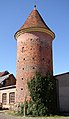 Tower of town wall
 -
 „Amtsbergturm“
 -
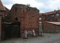 Town wall
 -
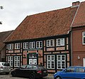 Timber framing
 -
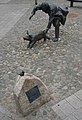 Sculpture on market square
 -
 River Motel
 -
 299 Pfennig Notgeld, showing a scene from the book Läuschen un Rimels by Fritz Reuter on the reverse


References
- ^ Bürgermeisterstichwahl Amt Wittenburg 04.10.2020, accessed 7 March 2022.
- ^ "Bevölkerungsstand der Kreise, Ämter und Gemeinden 2022" (XLS) (in German). Statistisches Amt Mecklenburg-Vorpommern. 2023.
External links
- Official website (German)
| International | |
|---|---|
| National | |
|
| This Ludwigslust-Parchim location article is a stub. You can help Wikipedia by expanding it. |