Wildersville, Tennessee | |
|---|---|
 Wildersville  Wildersville | |
| Coordinates: 35°46′53″N 88°21′37″W / 35.78139°N 88.36028°W | |
| Country | United States |
| State | Tennessee |
| County | Henderson |
| Area | |
| • Total | 1.68 sq mi (4.36 km2) |
| • Land | 1.68 sq mi (4.36 km2) |
| • Water | 0.00 sq mi (0.00 km2) |
| Elevation | 479 ft (146 m) |
| Population | |
| • Total | 161 |
| • Density | 95.61/sq mi (36.91/km2) |
| Time zone | UTC-6 ( Central (CST)) |
| • Summer ( DST) | UTC-5 (CDT) |
| ZIP code | 38388 |
| Area code | 731 |
| GNIS feature ID | 1274564 [3] |
Wildersville is an unincorporated community in Henderson County, Tennessee, United States. [3] The zipcode is 38388. [4]
Demographics
| Census | Pop. | Note | %± |
|---|---|---|---|
| 2020 | 161 | — | |
| U.S. Decennial Census [5] | |||
Notes
- ^ "ArcGIS REST Services Directory". United States Census Bureau. Retrieved October 15, 2022.
- ^ "Census Population API". United States Census Bureau. Retrieved October 15, 2022.
- ^ a b "Wildersville, Tennessee". Geographic Names Information System. United States Geological Survey, United States Department of the Interior.
- ^ United States Postal Service (2012). "USPS - Look Up a ZIP Code". Retrieved February 15, 2012.
- ^ "Census of Population and Housing". Census.gov. Retrieved June 4, 2016.
Municipalities and communities of
Henderson County, Tennessee, United States | ||
|---|---|---|
| Cities | 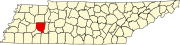 | |
| Towns | ||
| CDPs | ||
|
Other communities | ||
| Footnotes | ‡This populated place also has portions in an adjacent county or counties | |
|
| This Henderson County, Tennessee geography–related article is a stub. You can help Wikipedia by expanding it. |