| This is an archive of past discussions. Do not edit the contents of this page. If you wish to start a new discussion or revive an old one, please do so on the current talk page. |
| Archive 1 | Archive 2 | Archive 3 | Archive 4 |
Artistic Mosaic location
Okay, who has seen where this piece of artwork is? --------- User:DanTD ( talk) 12:47, 9 July 2016 (UTC)

-
Times Square.
Vcohen (
talk) 12:53, 9 July 2016 (UTC)
- Belated thanks here. --------- User:DanTD ( talk) 18:09, 12 July 2016 (UTC)
Vault

An E train and such a vault. Where could it be? Vcohen ( talk) 11:16, 23 July 2016 (UTC)
- @ Vcohen: Lexington Avenue – 63rd Street. This is probably a construction reroute. epicgenius ( talk) 03:54, 26 July 2016 (UTC)
Train of Many Colors

Could anybody identify this station? Vcohen ( talk) 09:02, 28 July 2016 (UTC)
- It's an elevated station with 2 tracks on the Flushing Line, so it's Court Square. Am I right?
Vcohen (
talk) 10:11, 28 July 2016 (UTC)
- Nah, too many trees to be in Long Island City. ---------
User:DanTD (
talk) 12:43, 28 July 2016 (UTC)
- And then the station is... Vcohen ( talk) 12:59, 28 July 2016 (UTC)
- If it is still elevated, IRT and two-track with side platforms, but not Court Square, it only can be Dyckman Street. Does it match the number of trees better?
Vcohen (
talk) 13:22, 28 July 2016 (UTC)
- No tunnel in site, no curves, and that hill in the background doesn't really convince me it's anywhere near Dyckman. If it wasn't for the lack of a flyover into the Corona Yard, I'd say it was
111th Street (IRT Flushing Line), but I'm not really sure this is on the IRT Flushing Line at all. ---------
User:DanTD (
talk) 14:06, 28 July 2016 (UTC)
- I agree that it may not be the Flushing Line. But do you agree that it has two tracks? 111th Street has four.
Vcohen (
talk) 15:12, 28 July 2016 (UTC)
- It's at Mets – Willets Point, facing west. Third track is out of frame to the left. Compare to
this shot.
Pi.1415926535 (
talk) 15:44, 28 July 2016 (UTC)
- Thank you very, very much.
Vcohen (
talk) 16:58, 28 July 2016 (UTC)
- I thought there might've been some other tracks we weren't seeing. --------- User:DanTD ( talk) 19:04, 28 July 2016 (UTC)
- That fits with the chaining code on the signal: IRT Flushing Line, about 8.4 miles from Times Square. I wonder if there's a database or google-maps hack for calculating these distances easily.
DMacks (
talk) 19:30, 28 July 2016 (UTC)
- Yeah, there should be. But the route is not best shown mileage-wise, at least for most passengers. epicgenius ( talk) 23:07, 28 July 2016 (UTC)
- Thank you very, very much.
Vcohen (
talk) 16:58, 28 July 2016 (UTC)
- It's at Mets – Willets Point, facing west. Third track is out of frame to the left. Compare to
this shot.
Pi.1415926535 (
talk) 15:44, 28 July 2016 (UTC)
- I agree that it may not be the Flushing Line. But do you agree that it has two tracks? 111th Street has four.
Vcohen (
talk) 15:12, 28 July 2016 (UTC)
- No tunnel in site, no curves, and that hill in the background doesn't really convince me it's anywhere near Dyckman. If it wasn't for the lack of a flyover into the Corona Yard, I'd say it was
111th Street (IRT Flushing Line), but I'm not really sure this is on the IRT Flushing Line at all. ---------
User:DanTD (
talk) 14:06, 28 July 2016 (UTC)
- Nah, too many trees to be in Long Island City. ---------
User:DanTD (
talk) 12:43, 28 July 2016 (UTC)

- Speaking of chaining codes... ---------
User:DanTD (
talk) 01:37, 29 July 2016 (UTC)
- That does seem consistent with that location.
DMacks (
talk) 02:09, 29 July 2016 (UTC)
- Yes, I already know where it is, because I took that picture. I just asked if that particular sign on the bottom of the wall is a chaining code. --------- User:DanTD ( talk) 03:30, 29 July 2016 (UTC)
- That does seem consistent with that location.
DMacks (
talk) 02:09, 29 July 2016 (UTC)
- Speaking of chaining codes... ---------
User:DanTD (
talk) 01:37, 29 July 2016 (UTC)
- Right:) And I'm saying "yes", because reading it as if it were one makes sense for that location. It's a reasonable overall format, the line code looks right, and the distance matches my ruler-measurement approximation along that line on google maps. And it also agrees with the information on the nameplate of that signal seen in this reverse-angle). DMacks ( talk) 03:36, 29 July 2016 (UTC)
- Okay. --------- User:DanTD ( talk) 06:02, 29 July 2016 (UTC)
An old one
I suspect File:NYC subway waiting outside.jpg is at Smith–Ninth Streets, but it's anyone's guess. epicgenius ( talk) 22:51, 2 August 2016 (UTC)
- I'm going to recategorize this. It seems like it really is at Smith-9th Streets. I don't know of any other four-track concrete viaduct stations other than Fourth Avenue, and Fourth Avenue has an arch along the entire platform. epicgenius ( talk) 21:42, 4 August 2016 (UTC)

Far Rockaway-Mott Avenue or Not?
I've been looking at this shot of the Access-A-Ride car near an IND Rockaway Line station, and I suddenly noticed platforms along the bridge. I've suspected this was at Far Rockaway-Mott Avenue (IND Rockaway Line) station. --------- User:DanTD ( talk) 20:55, 19 August 2016 (UTC)
.jpg)
- Can't be Far Rockaway-Mott Avenue since that station has an island platform and the one in the picture has side platforms. — Preceding unsigned comment added by 173.3.53.224 ( talk) 00:04, 20 August 2016 (UTC)
- Beach-36th, about at this angle. Pi.1415926535 ( talk) 15:46, 20 August 2016 (UTC)
The same shot again

I have found an article, containing a photo of this object and talking about 76th Street, but I still don't understand where the object is... Vcohen ( talk) 20:31, 17 August 2016 (UTC)
- Looks like a trackway in the never completed Fulton Street Line tunnel past Euclid Avenue, though I can't say for sure. 66.55.12.1 ( talk) 23:56, 23 August 2016 (UTC)
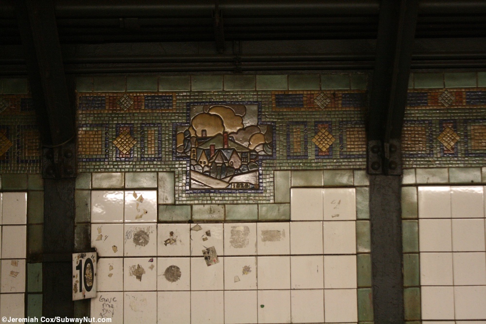
Squire J. Vickers tiles


These two images are already in the Times Square–42nd Street/Port Authority Bus Terminal (New York City Subway) article. The article states that the first one is by Squire J. Vickers and the second recreates it, but the images are not categorized by station. Which of the three IRT stations do they belong to? Vcohen ( talk) 18:39, 31 August 2016 (UTC)
I have seen these at Times Square.-- Kew Gardens 613 ( talk) 18:42, 31 August 2016 (UTC)
- I also see them in the previous thread. --------- User:DanTD ( talk) 20:03, 31 August 2016 (UTC)
- Yes, the Times Square–42nd Street/Port Authority Bus Terminal (New York City Subway) article is about the Times Square complex. I need the exact station. Vcohen ( talk) 20:15, 31 August 2016 (UTC)
I saw them in the passageway to walk from the Uptown Broadway – Seventh Avenue Line to the Downtown Broadway – Seventh Avenue Line.-- Kew Gardens 613 ( talk) 20:17, 31 August 2016 (UTC)
A station again

Is there a chance to identify this station? Vcohen ( talk) 18:43, 27 August 2016 (UTC)
- Those mosaics look like they have a variation of the
Flag of Jamaica, but I wouldn't be so quick to confirm that this is any station in
Jamaica, Queens. ---------
User:DanTD (
talk) 19:09, 27 August 2016 (UTC)
- The name of Jamaica, Queens, has nothing to do with the island country. Any similarity in those tiles, which are found in many places on BMT lines, is purely coincidental.
oknazevad (
talk) 21:16, 28 August 2016 (UTC)
- That doesn't mean there aren't people who use this coincidence. --------- User:DanTD ( talk) 12:23, 1 September 2016 (UTC)
- The name of Jamaica, Queens, has nothing to do with the island country. Any similarity in those tiles, which are found in many places on BMT lines, is purely coincidental.
oknazevad (
talk) 21:16, 28 August 2016 (UTC)
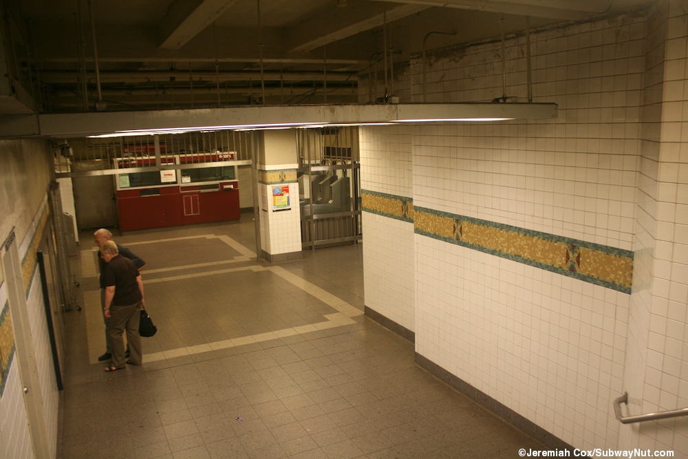
There is transit wireless and the photo is tagged as being in Manhattan so this might help [1] I have tried looking at the neighborhood map, but I can't determine what it says. I looked here. [2]-- Kew Gardens 613 ( talk) 01:24, 28 August 2016 (UTC)
- Well it says "Pennsylvania Station Times Square" on the neighborhood maps, and it has BMT tiles. So I am guessing that it's a Broadway Line station.
epicgenius (
talk) 19:39, 28 August 2016 (UTC)
- I'm guessing, based on that, that this might be one of the stairways at 34th Street–Herald Square, near the Broadway Line platforms, connecting it to the Sixth Ave line and PATH areas. I was just there last week, and it looks somewhat familiar.
oknazevad (
talk) 21:16, 28 August 2016 (UTC)
- I agree with this guess. I'm in Florida right now for vacation (the theme parks in the center of the state, to be precise) so I cant easily check, but I saw this two weeks ago and it looks about right.
epicgenius (
talk) 03:27, 29 August 2016 (UTC)
- Remember what I said about the Flag of Jamaica? The Confederate Flag also uses the Saltire, so I suspect these are the Squire J. Vickers tiles as seen in the next thread. --------- User:DanTD ( talk) 12:21, 1 September 2016 (UTC)
- I agree with this guess. I'm in Florida right now for vacation (the theme parks in the center of the state, to be precise) so I cant easily check, but I saw this two weeks ago and it looks about right.
epicgenius (
talk) 03:27, 29 August 2016 (UTC)
- I'm guessing, based on that, that this might be one of the stairways at 34th Street–Herald Square, near the Broadway Line platforms, connecting it to the Sixth Ave line and PATH areas. I was just there last week, and it looks somewhat familiar.
oknazevad (
talk) 21:16, 28 August 2016 (UTC)
R-160 signs

Here's another instance where I already know the location; I've seen this sign along other lines (mostly on BMT lines), but this one on the right is at Cleveland Street (BMT Jamaica Line). Does anyone know what the meaning of this sign is? --------- User:DanTD ( talk) 20:10, 31 August 2016 (UTC)
- [3]. Vcohen ( talk) 20:19, 31 August 2016 (UTC)
- This sign means that trains using R160s, which have the conductor position as 4/4 should be right near the board. This is opposed to R32s which have the 5/3 conductors position. Therefore there is a different conductors board for the R32/R42s.--
Kew Gardens 613 (
talk) 20:20, 31 August 2016 (UTC)
- Yeah, and conductors need to point at these boards to confirm that motormen have stopped at the right location and that the train doors can be opened.
216.53.168.62 (
talk) 14:47, 1 September 2016 (UTC)
- Thanks, and I just remembered where I saw the other one. It was at East 105th Street on the BMT Canarsie Line, and Jim Henderson took this one. I could've sworn GK tramrunner229 also took another one too. --------- User:DanTD ( talk) 15:31, 2 September 2016 (UTC)
- Yeah, and conductors need to point at these boards to confirm that motormen have stopped at the right location and that the train doors can be opened.
216.53.168.62 (
talk) 14:47, 1 September 2016 (UTC)
Entrance

This should be in Lower Manhattan, I guess... Vcohen ( talk) 19:35, 5 September 2016 (UTC)
- I vaguely remember seeing this on some webpage. ---------
User:DanTD (
talk) 20:02, 5 September 2016 (UTC)
- Here's
something similar at
Wall Street (IRT Lexington Avenue Line), but the doorway in this one is kind of narrow. ---------
User:DanTD (
talk) 20:07, 5 September 2016 (UTC)
- Thank you,
I see it. But I don't see any attribute of a subway entrance there. Is it a real entrance? That signboard might have remained from earlier time.
Vcohen (
talk) 20:40, 5 September 2016 (UTC)
- Yup,
Wall Street (IRT Lexington Avenue Line). The store is on a stairway landing, with passageways (or additional staircases) to the side(s). That is, foot traffic comes down into a T intersection, with the store blocking the fourth (straight-ahead) direction of the T. In this photo, the portable signboard and the sign in the window both indicate that the storefront is wider than can be seen looking down the stairs, so there is easily be space to walk to the left or right at the bottom of the stairs, but the corridor walls/ceilings themselves are too far to the sides to see them.
[4] talks about it, and has
this photo from that same interesting/deceptive perspective.
DMacks (
talk) 22:02, 5 September 2016 (UTC)
- I agree that it's at Wall Street.
Here's a Forgotten NY page on the entrance. (Oh yeah. Did I mention that it's also a
Subway entrance in addition to being a
subway entrance? Look closely, it's both...)
epicgenius (
talk) 01:56, 6 September 2016 (UTC)
- Sorry, I didn't ask for urine on this.
DMacks (
talk) 05:00, 6 September 2016 (UTC)
- Well, I didn't want sausage on that sub anyway.
epicgenius (
talk) 12:43, 6 September 2016 (UTC)
- "Did you want that Italian to go?" "Nah, he's not bothering anyone."
DMacks (
talk) 13:46, 6 September 2016 (UTC)
- "You want meatballs with that?" "No thanks, my hands are full." epicgenius ( talk) 15:12, 6 September 2016 (UTC)
- "Did you want that Italian to go?" "Nah, he's not bothering anyone."
DMacks (
talk) 13:46, 6 September 2016 (UTC)
- Well, I didn't want sausage on that sub anyway.
epicgenius (
talk) 12:43, 6 September 2016 (UTC)
- The point is that the entrance is signed as a Subway entrance, but not as a subway entrance. I can see neither a green/red lamp nor a sign with the station name. However, I got the impression that both Wall Street stations have several unsigned entrances, such as this or this. Vcohen ( talk) 15:42, 6 September 2016 (UTC)
- Sorry, I didn't ask for urine on this.
DMacks (
talk) 05:00, 6 September 2016 (UTC)
- I agree that it's at Wall Street.
Here's a Forgotten NY page on the entrance. (Oh yeah. Did I mention that it's also a
Subway entrance in addition to being a
subway entrance? Look closely, it's both...)
epicgenius (
talk) 01:56, 6 September 2016 (UTC)
- Yup,
Wall Street (IRT Lexington Avenue Line). The store is on a stairway landing, with passageways (or additional staircases) to the side(s). That is, foot traffic comes down into a T intersection, with the store blocking the fourth (straight-ahead) direction of the T. In this photo, the portable signboard and the sign in the window both indicate that the storefront is wider than can be seen looking down the stairs, so there is easily be space to walk to the left or right at the bottom of the stairs, but the corridor walls/ceilings themselves are too far to the sides to see them.
[4] talks about it, and has
this photo from that same interesting/deceptive perspective.
DMacks (
talk) 22:02, 5 September 2016 (UTC)
- Thank you,
I see it. But I don't see any attribute of a subway entrance there. Is it a real entrance? That signboard might have remained from earlier time.
Vcohen (
talk) 20:40, 5 September 2016 (UTC)
- Here's
something similar at
Wall Street (IRT Lexington Avenue Line), but the doorway in this one is kind of narrow. ---------
User:DanTD (
talk) 20:07, 5 September 2016 (UTC)
Mezzanine

The sign above the passengers' heads says "6 Avenue" and "...pson Street" (not sure). Vcohen ( talk) 14:41, 8 September 2016 (UTC)
-
Canal Street (IND Eighth Avenue Line). The overhead sign is clearish to me as: "L[something]t Street" / "Thompson Street" / "Canal Streeet & 6 A[something]". The Canal Street A/C/E station is the corner of Laight, Thompson, Canal, and 6th Av.
DMacks (
talk) 14:52, 8 September 2016 (UTC)
- Wow, I did not see that sign. Thank you.
Vcohen (
talk) 15:25, 8 September 2016 (UTC)
- And I had to look a few times to find the passenger and the sign you were seeing. Maybe I've evolved to live anonymously in a big city and simply ignore people:)
DMacks (
talk) 16:16, 8 September 2016 (UTC)
- Anyone notice the plaque on the mezzanine wall? I've only ever seen it at Canal Street (and I thought
Jackson Heights–Roosevelt Avenue was weird for having tiled walls within some of the columns between the express tracks).
epicgenius (
talk) 00:45, 12 September 2016 (UTC)
- That is a Path through History sign noting a location that people might want to check out. There is also one at Kew Gardens at the 78th Avenue mezzanine for the Queens County Farm Museum that can be reached by using the Q46 bus upstairs. They have these in other locations.--
Kew Gardens 613 (
talk) 01:06, 12 September 2016 (UTC)
- I know; I wasn't referring to the Path through History sign. (At Delancey Street–Essex Street, there's one for the Lower East Side Tenement Museum, a weird attraction if I ever did see one.) It seems as though I may have been confusing, and I apologize for that. I was referring to the "Canal Street" tile mosaic in the background, which is even weirder in that it's replicated in the express trackside columns. epicgenius ( talk) 01:53, 12 September 2016 (UTC)
- That is a Path through History sign noting a location that people might want to check out. There is also one at Kew Gardens at the 78th Avenue mezzanine for the Queens County Farm Museum that can be reached by using the Q46 bus upstairs. They have these in other locations.--
Kew Gardens 613 (
talk) 01:06, 12 September 2016 (UTC)
- Anyone notice the plaque on the mezzanine wall? I've only ever seen it at Canal Street (and I thought
Jackson Heights–Roosevelt Avenue was weird for having tiled walls within some of the columns between the express tracks).
epicgenius (
talk) 00:45, 12 September 2016 (UTC)
- And I had to look a few times to find the passenger and the sign you were seeing. Maybe I've evolved to live anonymously in a big city and simply ignore people:)
DMacks (
talk) 16:16, 8 September 2016 (UTC)
- Wow, I did not see that sign. Thank you.
Vcohen (
talk) 15:25, 8 September 2016 (UTC)
Uncertain BMT Fourth Avenue Line station
I'm fairly convinced that wherever this may be, it's on the BMT Fourth Avenue Line between 36th Street and Atlantic Avenue-Barclays Center. --------- User:DanTD ( talk) 21:48, 18 September 2016 (UTC)

- 9th Street - the next file from the flickr set, taken 9 seconds later, is indisputably at 9th. Always check the next and previous images on flickr. Pi.1415926535 ( talk) 22:58, 18 September 2016 (UTC)
PATH?
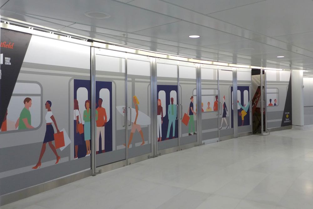
Why is this image called "PATH Station Entrance Construction"? Is this the same building? Is this view related to that entrance? Vcohen ( talk) 09:16, 19 September 2016 (UTC)
- That's
Westfield World Trade Center, the new shopping mall at the WTC complex, which does have a direct connection to the PATH station. It's obvious from the Westfield sign in the second image. (Westfield is a major owner of shopping malls.)
oknazevad (
talk) 11:41, 19 September 2016 (UTC)
- Is the new PATH entrance visible at least in one of these photos?
Vcohen (
talk) 13:11, 19 September 2016 (UTC)
- This is the WTC Transport Hub entrance, but this view out of fare control and out of view from the actual station. epicgenius ( talk) 00:04, 20 September 2016 (UTC)
- Is the new PATH entrance visible at least in one of these photos?
Vcohen (
talk) 13:11, 19 September 2016 (UTC)
Future Subway Entrance
Where is this? Is this place related to the NYC Subway? Is this image worth uploading? Vcohen ( talk) 08:59, 13 September 2016 (UTC)
- Is this the future entrance from the WTC Hub to the IRT Cortlandt Street station?
Vcohen (
talk) 19:09, 13 September 2016 (UTC)
- Yes, and also to Cortland Street on the BMT and the World Trade Center on the IND. epicgenius ( talk) 00:06, 20 September 2016 (UTC)
Old Image

This is Journal Square. [5]-- Kew Gardens 613 ( talk) 19:08, 10 October 2016 (UTC)
- I suspected as much. --------- User:DanTD ( talk) 01:19, 11 October 2016 (UTC)
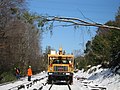
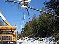
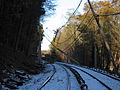
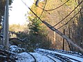
Snow-covered Unknown New Haven Line
This image on the New Haven Line is described as being in an unknown location, but I suspect it's in Greenwich near the Mianus River Railroad Bridge. The excessive wires and transformers make me think that. --------- User:DanTD ( talk) 01:53, 17 October 2016 (UTC)

SIR station only identified as "Summer Station"
Back in September a editor took this pic of a Staten Island Railway station, but there doesn't seem to be any clue of which one it is. I found it miscategorized as "New York," so I narrowed the thing down, but obviously it's not good enough. --------- User:DanTD ( talk) 13:16, 27 October 2016 (UTC)

This is Atlantic. It has this overpass which is in bad condition.-- Kew Gardens 613 ( talk) 18:24, 27 October 2016 (UTC)
- That was among my list of possibilities. --------- User:DanTD ( talk) 02:42, 28 October 2016 (UTC)
A third blizzard covered Flushing Line pic
Another location for the IRT Flushing Line clouded in heavy snow. The one thing I noticed is that there's a light post on the left, so this might be from a station. For the moment, I suspect it's around 46th Street–Bliss Street (IRT Flushing Line), but that light is east of where the platforms end and this Manhattan-bound train looks like it's climbing a grade before making the curve here. --------- User:DanTD ( talk) 23:19, 30 October 2016 (UTC)
- @
DanTD: This shot was taken from
33rd Street–Rawson Street (IRT Flushing Line). The McDonald's is south of Queens Boulevard at 38-02 Queens Blvd, so this is very likely facing east.
epicgenius – (
talk) 01:17, 8 November 2016 (UTC)
- That was a surprise, because the train not only looks like it's climbing a grade, but I thought it was going around a curve too, and I see that I was wrong. Here's another shot of the McDonald's from the station. Thanks a lot. --------- User:DanTD ( talk) 03:21, 8 November 2016 (UTC)
.jpg)
Art for Transit ID on the Concourse Line
Something a little closer to the city, and at another station I can already identify. This is some kind of artwork above the 174th Street entrance of the 174th–175th Streets (IND Concourse Line), and I tried to find something on it from MTA's website, but so far I haven't seen a thing. --------- User:DanTD ( talk) 16:23, 1 October 2016 (UTC)

- Here's
another view...so it was probably painted in 1995.
DMacks (
talk) 19:28, 1 October 2016 (UTC)
- Well, yes. But that doesn't tell me way the name of the work is. --------- User:DanTD ( talk) 15:20, 29 November 2016 (UTC)
Harlem Line images that don't match geotags
I sought some info on this before, but never had any replies. It involves the locations of a lot of Metro-North images;
-
 The geotags for these two, and possibly some others...
 -
 ..claim they're in the North White Plains Yard.
.jpg)
.jpg)
However, the description for both of them, as well as some others is as follows;
"Clearing switches and interlockings in Metro-North Mott Haven territory. Phoo: MTA Metro-North Railroad"
-
 Yet only this one looks like it's from Mott Haven.
.jpg)
So I suppose "Mott Haven territory" extends beyond the South Bronx according to MTA. If not, then what's up with the descriptions? --------- User:DanTD ( talk) 21:53, 5 December 2016 (UTC)
- It wouldn't surprise me if whoever handles MTA's social media feed has no idea where these pics were actually taken and makes guesses or just writes what people told them.
Daniel Case (
talk) 22:56, 5 December 2016 (UTC)
- Right; we seldom know where a picture picked up its description and EXIF geotag. There's no audit trail we can check. These have EXIF that says they were shot by an iPhone, which presumably had its geotagger turned on but that's pretty slim. Especially slim since official MTA photos are mostly made by Patrick Cashin or some other staff professional with DSLR, careful composition, sharp focus, and no GPS. Jim.henderson ( talk) 14:57, 9 December 2016 (UTC)
Another Metro-North image; Grand Central Terminal
Okay people, which part of Grand Central Terminal does this look like to you? --------- User:DanTD ( talk) 16:50, 24 December 2016 (UTC)

Doubtful Chambers Street Station
The geotag for this station claiming to be at Chambers Street says it's on the IRT Broadway-Seventh Avenue Line, but I have serious doubts about that -- almost as serious as the one about the 90th Street (IRT Flushing Line) station being in Jackson Heights a while back. If I'm wrong, please show me the evidence. --------- User:DanTD ( talk) 03:43, 31 December 2016 (UTC)
- I see the same sign as here: "Exit Chambers St, Park Place, Warren St. Transfer A C 2 3." Vcohen ( talk) 09:25, 31 December 2016 (UTC)

- I agree. The sign over the platform has bullets for 2/3 and C (IRT and IND, not just IRT). The sign also lists a street-name of "[something] Place", which could be Park Place but I don't see any ...Place streets close to the other station. And having a track end is consistent with
Chambers Street–World Trade Center/Park Place (New York City Subway) but not with
Chambers Street (IRT Broadway–Seventh Avenue Line).
DMacks (
talk) 09:31, 31 December 2016 (UTC)
- What really threw me off was the dead end tracks there. ---------
User:DanTD (
talk) 14:36, 31 December 2016 (UTC)
- @ DanTD: It's World Trade Center (IND Eighth Avenue Line). The thing is that the local tracks end pretty abruptly at the point. As in, the exit to the World Trade Center station (PATH) is right past the bumper. This is taken from the Vesey Street exit.@ DMacks and Vcohen: it is Chambers St/Warren St/Park Place. epicgenius ( talk) 17:34, 9 January 2017 (UTC)
- What really threw me off was the dead end tracks there. ---------
User:DanTD (
talk) 14:36, 31 December 2016 (UTC)
LILCO Diesel Switcher in 1957
This might be one of our toughest ones yet. It's an image of a diesel switcher owned by the Long Island Lighting Company using an LIRR line. My first instincts have been some place on the North Shore. The scene has two tracks, and there's a power plant in the background, but that train is a little too close to the water. --------- User:DanTD ( talk) 14:17, 27 January 2017 (UTC)

A little outside NYC...

Here's a concourse at an unidentified PATCO station in Philly. Anyone got a clue which? Pi.1415926535 ( talk) 00:38, 25 December 2016 (UTC)
- There's some lettering on a mosaic way off in the distance, but I can't see the damn thing. :( ---------
User:DanTD (
talk) 14:42, 5 January 2017 (UTC)
- UPDATE: I just sent a message to the uploader asking about the location. --------- User:DanTD ( talk) 13:16, 2 February 2017 (UTC)
Subway by Cemetery in "I Ought to Be in Pictures."
Has anyone seen the 1982 Walter Matthau-Dinah Manoff movie " I Ought to Be in Pictures?" I can't find a shot online, but the opening scene contains an elevated station next to a cemetery, where Dinah Manoff's character steps off of to visit the grave of her dead grandmother. My first thought of a scene like that is Woodlawn (IRT Jerome Avenue Line) or something of that nature, but her character is supposed to be from Brooklyn. So my next suspicion is Cypress Hills (BMT Jamaica Line), but I don't see any evidence of a curve. So where could it be? --------- User:DanTD ( talk) 02:33, 3 January 2017 (UTC)
- Okay, I got a screen grab and posted it the only way I know how at this point. Now can somebody give me a location? --------- User:DanTD ( talk) 02:20, 10 February 2017 (UTC)
Future Subway Entrance is back

Hello all,
This picture has already been discussed here, and I already know that this entrance will lead to several subway stations. Today I found two new links: one on YouTube and one on Google Maps Street View. Could anybody explain me the position of these points relative to each other? Which of these links can I use in the Cortlandt Street (IRT Broadway–Seventh Avenue Line) article? Vcohen ( talk) 20:44, 27 January 2017 (UTC)
- They are the same place. The person taking the video walks down the same stairs as in the Google Maps link. But I don't think either really add anything to the article. The YouTube video isn't very good, honestly. I strongly disagree with adding a ton of streetview links to an article. Just as WP:EL says we should only link once to an official website and if readers want to find out more they can navigate that website on their own, we should have at most one StreetView link; it readers want to explore the station, they can do that on their own. It's just too many links to have a bunch. We're not here to pre-navigate for readers, and we're not here to drive traffic to Google. I think we should ultimately get rid of all of them and let the geotag link at the top be enough. oknazevad ( talk) 14:48, 2 February 2017 (UTC)
I have found it. This entrance is to the R. Vcohen ( talk) 18:48, 14 February 2017 (UTC)
- There's also a future entrance to the 1, with the same banner, on the other end.
epicgenius (
talk) 20:39, 14 February 2017 (UTC)
- As far as I see,
the banner is different.
Vcohen (
talk) 21:07, 14 February 2017 (UTC)
- I must have seen incorrectly. My bad. epicgenius ( talk) 21:51, 14 February 2017 (UTC)
- As far as I see,
the banner is different.
Vcohen (
talk) 21:07, 14 February 2017 (UTC)
LIRR yard (?) during a blizzard
The image below looks like it's from an LIRR yard, but I don't have the slightest idea which one it is. --------- User:DanTD ( talk) 22:59, 10 August 2016 (UTC)
- Unarchiving: this is not an LIRR line, but rather a stolen photo from Europe: [6] — Train2104 ( t • c) 04:00, 28 February 2017 (UTC)
Snowy IRT Jerome Avenue tracks with a Waterfront View?
This image of the IRT Jerome Avenue Line isn't at a station, but it's a nice one with some snow. The trouble is I can't figure out the location. Somewhere behind the tracks is what appears to be a waterfront view, and the only place I can think of where such a view would be possible is Jerome Park Reservoir. --------- User:DanTD ( talk) 14:39, 5 January 2017 (UTC)
- @ DanTD: With the snow, it technically could be Van Cortlandt Park. If that's the case, we are at Woodlawn. Not sure, though. epicgenius ( talk) 17:29, 9 January 2017 (UTC)
.jpg)
Another snow-covered LIRR line
I still never received any answer on the last Long Island Rail Road line I tried to get identified, but that doesn't mean I can't show off another and ask if anybody knowns where it is. --------- User:DanTD ( talk) 03:07, 1 October 2016 (UTC)
.jpg)
- Unarchiving: Greenport. —
Train2104 (
t •
c) 04:00, 28 February 2017 (UTC)
- So then this is Fourth Street? ---------
User:DanTD (
talk) 16:23, 28 February 2017 (UTC)
- Yeah. That little wooden fence you see in the background appears to be the the one around the turntable at the RMLI. —
Train2104 (
t •
c) 16:36, 28 February 2017 (UTC)
- Ahh, I see. I caught images of this place when there were more trees. --------- User:DanTD ( talk) 17:56, 28 February 2017 (UTC)
- Yeah. That little wooden fence you see in the background appears to be the the one around the turntable at the RMLI. —
Train2104 (
t •
c) 16:36, 28 February 2017 (UTC)
- So then this is Fourth Street? ---------
User:DanTD (
talk) 16:23, 28 February 2017 (UTC)
SIR station

Could anybody identify this station? Vcohen ( talk) 15:47, 3 March 2017 (UTC)
- It's Eltingville. The CITGO and residential building at far right were my clues. Pi.1415926535 ( talk) 16:46, 3 March 2017 (UTC)
LIRR Yard; West Side, or somewhere else?
I have to know about these images of some apparent Long Island Rail Road preparation for Hurricane Irene images in 2011;
-
 "Hurricane Irene preparation: LIRR employees lay down an Aqua-Barrier to help prevent water from flowing into the LIRR's tunnels to Penn Station. Photo by Metropolitan Transportation Authority / John Kettell."
 -
 The trouble is, it doesn't describe which tunnel to Penn Station this is...
 -
 .. although considering the width, I find it hart to believe it's the one to Long Island City.
-_IMG00005-20110827-0941_(6085662125).jpg)
-_IMG00010-20110827-1118_(6085662147).jpg)
-_IMG00694-20110827-1239_(6086208770).jpg)
So am I wrong in suspecting this is the West Side Yard? --------- User:DanTD ( talk) 22:54, 7 March 2017 (UTC)
- I don't recall the aqua dam being used anywhere other than the WSY leads. — Train2104 ( t • c) 03:48, 8 March 2017 (UTC)
Kings Highway
Hello all,


How can I distinguish between Kings Highway (IND Culver Line) and Kings Highway (BMT Brighton Line)? The only difference I found is the distance between the platforms. In these two pictures I estimate it to be one track, so I have categorized them under the Culver Line. Am I right? Vcohen ( talk) 09:15, 15 March 2017 (UTC)
- Perhaps the canopy supports are widening upwards at the Culver Line station only...
Vcohen (
talk) 20:57, 15 March 2017 (UTC)
- Yeah, it is the Culver Line. It looks one track wide, and two tracks would be a much wider gap. Plus, the Brighton Line station has very narrow platforms with yellow edge treads, while the platforms here look wider. epicgenius ( talk) 15:41, 24 March 2017 (UTC)
- R46s are used on the F on the Culver Line not on the B or Q on the Brighton Line.--
Kew Gardens 613 (
talk) 16:24, 24 March 2017 (UTC)
- Although true for the most part, that could foreseeably change (e.g. special reroute). epicgenius ( talk) 00:31, 25 March 2017 (UTC)
Still seeking these Metro-North station images
Okay, I'm trying this again, since nobody was able to answer me the first time.
-
I originally thought the concrete benches on the platform were a clue... maybe not.
-
There's also this other image which was snapped by the same woman.
-
 Meanwhile there's still this image on the New Haven Line, that I think might be near the Mianus River Railroad Bridge.
Along with the gallery still unanswered in Archive page #3 which I still think is on the Harlem Line in Central or Northern Westchester County, these three still have yet to be narrowed down. --------- User:DanTD ( talk) 03:26, 31 March 2017 (UTC)
- Mianus River Bridge is between MP 29 and 30, so the 2969 on the marker makes me think that's it. –
Train2104 (
t •
c) 04:06, 11 April 2017 (UTC)
- Good to know. Any way we can get views of the mileposts for confirmation? --------- User:DanTD ( talk) 15:33, 12 April 2017 (UTC)
Revisiting a group of Metro-North images
Before a lot of our other stuff is archived, I want to try again to ask about a gallery of undetermined Metro-North images that I still suspect are somewhere on the Harlem Line;
-
 They all look like they're north of Valhalla...
 -
 .. or at least north of the North White Plains Yard...
 -
 .. the high power lines crossing the tracks might be a clue...
 -
 .. and I previously thought it might've been south of Mount Pleasant...
 -
 .. but for all I know, this could go as far north as Croton Falls.
 -
 I think I'll toss this one in too for good measure.
 -
 Somehow I don't think this is the Harlem Line though,...
 -
 The same goes for this one, although I could be wrong.
-_IMG_1596_(6303571470).jpg)
-_IMG_1597_(6303047507).jpg)
-_IMG_1598_(6303573628).jpg)
-_IMG_1599_(6303049331).jpg)
-_IMG_1600_(6303049905).jpg)
-_IMG_1603_(6303578368).jpg)
-_IMG00009-20111031-1039_(6303039303).jpg)
-_IMG00010-20111031-1039_(6303564908).jpg)
Any ideas would be helpful. --------- User:DanTD ( talk) 13:57, 4 June 2017 (UTC)
Lonely car
Hello all,
Where did they catch this car? Vcohen ( talk) 09:02, 14 June 2017 (UTC)
- http://untappedcities.com/2017/05/08/authentic-retired-graffitied-nyc-subway-car-is-inside-empty-42nd-street-storefront/ -- Kew Gardens 613 ( talk) 10:52, 14 June 2017 (UTC)
Escalator video

Am I right that these are two images of the same escalator? Vcohen ( talk) 08:05, 17 July 2017 (UTC)
- Yes.-- Kew Gardens 613 ( talk) 21:40, 17 July 2017 (UTC)
Pattern, pattern on the wall
Am I right that the X pattern in this photo is the same as here? If I am, the station is 34th Street–Penn Station (IRT Broadway–Seventh Avenue Line) and not Times Square–42nd Street (IRT Broadway–Seventh Avenue Line). Vcohen ( talk) 06:42, 5 September 2017 (UTC)
- Yes. Times Square has the Confederate flag design. This design is Penn Station. epicgenius ( talk) 15:54, 6 September 2017 (UTC)
Mysterious 6 train at Astor Place
Another question about identifying a car rather than a station. It's a 6 train arriving at Astor Place (IRT Lexington Avenue Line), but no info about the train itself. I suspect it's either an R142 or R142A, but confirmation of either is welcome. --------- User:DanTD ( talk) 23:04, 27 September 2017 (UTC)
.jpg)
- R142s have never run on the 6. It is an R142A.-- Kew Gardens 613 ( talk) 23:13, 27 September 2017 (UTC)
Tunnels
Here is a collection of tunnels.
-
 The author is not sure that it's Fifth - 59th
 -

-
 Borough Hall, but which of the two?
 -


Could anybody help me? Thanks in advance. Vcohen ( talk) 09:36, 14 August 2017 (UTC)
- Borough Hall image is from Brooklyn-bound side (river tunnel is on the left), 4/5 line. I took this photo. Wwward ( talk) 03:05, 4 October 2017 (UTC)
- The first one is clearly Fifth Avenue-59th Street. The third is the station on the 4 and 5. This can be determined by looking at Peter Dougherty's track maps, which indicate a double crossover west of he station on the 4 and 5. The fourth says that it is "the away-from-manhattan bound 2 line, seen from atlantic ave."
The second one is in Manhattan, and based on the tunnel design, I would guess it was on Central Park West somewhere.-- Kew Gardens 613 ( talk) 10:07, 14 August 2017 (UTC)
- Thank you very much! Vcohen ( talk) 10:46, 14 August 2017 (UTC)
- You are welcome. I enjoy doing this.-- Kew Gardens 613 ( talk) 10:47, 14 August 2017 (UTC)
- The second blue image is from the 1 line at 23rd street facing the downtown tunnel. I took the photo. Wwward ( talk) 03:05, 4 October 2017 (UTC)
Platform art

Where is it? The colors are like at Astor Place, but I cannot find this drawing in any picture of that station. Vcohen ( talk) 07:31, 3 October 2017 (UTC)
- https://www.flickr.com/photos/wwward0/36048158413/ The tag here says Atlantic-Pacific.-- Kew Gardens 613 ( talk) 19:39, 3 October 2017 (UTC)
- inner platform at Atlantic/Barclay's Center (I abhor the renaming of that station,) 4/5 line Manhattanbound side. I took this photo. Wwward ( talk) 03:05, 4 October 2017 (UTC)
IRT Cortlandt Street
Is this indeed a future entrance? Vcohen ( talk) 08:53, 7 October 2017 (UTC)
- I've walked past it a few times and I can't quite tell. I'm thinking that it is an entrance because the station is right below the site, but usually during recent construction, the entrances aren't completed until right before the station opened. The other possibility is that this leads to the underground
Westfield World Trade Center, which in turn leads to multiple subway stations and the PATH.
epicgenius (
talk) 14:13, 7 October 2017 (UTC)
- Thank you. So, I'll assume it is not.
Vcohen (
talk) 14:34, 7 October 2017 (UTC)
- I actually took a closer look at the street view, and realized that the station is shallow enough below the ground for the two stairs to, quite possibly, be future entrances. I'm not saying I know for sure, though. epicgenius ( talk) 01:49, 8 October 2017 (UTC)
- Thank you. So, I'll assume it is not.
Vcohen (
talk) 14:34, 7 October 2017 (UTC)
More unidentified cars
Here's yet another incident where I have to ask about identifying cars rather than stations;
-
 Nice shot, but are they even the same cars?
 -
 Somehow I doubt this is an R188.
 -
 Another incident where I'm not sure I should even ask, because I'm convinced it's an R46.


There's also another one I can't identify in this category, but since I took the picture myself, I don't even want to try adding it to the list. --------- User:DanTD ( talk) 18:19, 5 October 2017 (UTC)
- The first image shows three trains of R188s on the 7.-- Kew Gardens 613 ( talk) 13:55, 29 October 2017 (UTC)
- The second one is an R142 on the 2 at Burke Avenue.-- Kew Gardens 613 ( talk) 13:54, 29 October 2017 (UTC)
- The third clearly is an R46.--
Kew Gardens 613 (
talk) 13:54, 29 October 2017 (UTC)
- Thanks on all three. I still like the first one, either way. --------- User:DanTD ( talk) 20:14, 29 October 2017 (UTC)
St. George Terminal, or just looks like it?
Can anybody convince me that the station in the image below isn't St. George (Staten Island Railway station)? --------- User:DanTD ( talk) 03:18, 23 November 2017 (UTC)

- Any other station would have open sky above the trains.
Vcohen (
talk) 11:23, 23 November 2017 (UTC)
- I thought so. Especially since I was there when I went on my Staten Island Railway photo crusade last week. I even spotted an MTA fleet of SIR trucks somewhere in the northeastern region of the island, which I regret not getting a pic of on my way there. --------- User:DanTD ( talk) 12:45, 23 November 2017 (UTC)
Another "should I even ask" thread
Let me guess; R32? --------- User:DanTD ( talk) 04:46, 1 December 2017 (UTC)
- The only other option is an R38, which does not look like that. epicgenius ( talk) 05:40, 1 December 2017 (UTC)

Some LIRR station in NYC
Please give me a good enough reason to believe this image is at Jamaica (LIRR station), and if not give me the station that it might actually be. --------- User:DanTD ( talk) 00:11, 16 December 2017 (UTC)
-_IMG986_(8463837562).jpg)
-
This is the building.
This is the water tower.
Here both of them are seen together.
Vcohen (
talk) 21:02, 16 December 2017 (UTC)
- Wow! That's closer to Dunton (LIRR station)! But the first link confirms it's Jamaica. --------- User:DanTD ( talk) 21:33, 16 December 2017 (UTC)
More Mysterious Metro-North Stuff
This guy who calls himself "Ken" has had a lot of diesel locomotive images with redundant categories and discovered that many of them were at stations that could be easily identified. Others, not so much.
-
 Most of them appear on the west side of the Hudson, although admittedly, I'm not sure about this one.
 -
 For some reason, I keep thinking this might be White Plains (Metro-North station).
 -
 Not sure about this one, but it looks like it's south of the Rockland County line.
 -
 And how about this Amtrak train? This one looks like it's on the Hudson Line somewhere.
 -
 Another "West of Hudson" train, that could be on either side of the border.


The ones I've been trying to identify on previous threads still don't have answers. --------- User:DanTD ( talk) 21:49, 27 November 2017 (UTC)
- I almost forgot about a fifth image. --------- User:DanTD ( talk) 22:01, 27 November 2017 (UTC)
- The Flickr page for the first one says that it was taken at Stamford.-- Kew Gardens 613 ( talk) 23:23, 27 November 2017 (UTC)
- The first has to be on the Hudson Line as there are two tracks next to each other, indicating a four-track layout. White Plains has three tracks.
This image is at the same location http://photobucket.com/gallery/user/KenSNJ/media/bWVkaWFJZDoyNDIwNzU5OA==/?ref=1-- Kew Gardens 613 ( talk) 23:37, 27 November 2017 (UTC)
- The link you showed me has some pop-ups that blocked the view, but I did some further research on images #2 and #4, and I realized they were Yonkers (Metro-North station). Now for the other two. --------- User:DanTD ( talk) 23:56, 27 November 2017 (UTC)
- Number 3 is Morristown, at the far west end of the platform. Still working on the last one. Pi.1415926535 ( talk) 06:22, 7 January 2018 (UTC)
72 Street headhouses

The 72nd Street station has two headhouses. I am trying to figure out how they look inside (without coming to NYC). This is the old one. This is the new one. So, which one is this → ? Vcohen ( talk) 10:51, 24 January 2018 (UTC)
- The southern one (the old one) - see File:72nd Street IRT Broadway 005 stitched.jpg. It belongs in Category:72nd Street old headhouse. The categorization of the image I just mentioned threw me off for a bit, but I then remembered that I have only been in the old headhouse, and this is it. epicgenius ( talk) 01:57, 25 January 2018 (UTC)
Storage, electrical shed or something else?
Everybody here knows about my November 2017 photographic rampage. On my way to Staten Island, I decided to snap some pics of stations in East New York, specifically in Cypress Hills and Broadway Junction. One of the stations I expanded the gallery on was Norwood Avenue (BMT Jamaica Line), which I later realized was also the spot where I could've stopped off and added new image for a gallery of the NRHP-listed Substation 401, but that's not what I'm asking about. It's this gangplank with a firehose, that's located on the crossunder between the two staricases to the corners of the intersection, right next to the one to the ticket booth, turnstiles and platform. --------- User:DanTD ( talk) 15:38, 13 February 2018 (UTC)

Old brick building near Ossining (Metro-North station)
The following may or may not even be railroad-related. I may even pass it along to WP:Hudson Valley; Just north of Ossining (Metro-North station), are two late-19th or early-20th century brick structures. One is on Westerly Avenue in the background along the Grand Central-bound tracks behind the Harbor Square Luxury Apartment complex. The other is an old New York Central Railroad power substation. It's the first of these two properties I want to know about. I know there was a bridge of some kind across the tracks close to these buildings that was still in the process of being demolished, because I can still see the crumbling concrete support for the bridge pylons between the tracks, and in some cases along Westerly Avenue itself. Whether it was a pedestrian bridge, an industrial bridge, or a signal bridge, it made me suspect that the old building on the left might've also belonged to the railroad. Or it may just have been a typical Hudson River waterfront factory of some kind.
-
 Was this building behind the apartment complex built by New York Central, or someone else?
 -
 Because I know the power sub-station on the right is a former NYC property.
 -
 Maybe this third pic will offer a clearer view.


So who knows what it was? I want to know before it gets torn down and replaced with more modern development, so I can rename the pictures. --------- User:DanTD ( talk) 23:52, 19 December 2017 (UTC)
- Looks like an old warehouse. Maybe a former freight depot? (actually, what it really looks like, specifically, is a rickhouse, a type of warehouse used for aging whiskey barrels, but I doubt Ossining has one of those, being that Upstate New York didn't have a significant distillation industry until modern times, and even that is still small.)
oknazevad (
talk) 14:07, 28 December 2017 (UTC)
- I'll stick with the idea of a warehouse for the time being, but in the meantime, I regret that with all the 38 pictures I took of Ossining station, I never tried for a decent shot of the substation north of it. ---------
User:DanTD (
talk) 17:07, 29 December 2017 (UTC)
- Actually, there's a fourth image which is clearer, but it's currently for a bridge over the Kill Brook Creek. --------- User:DanTD ( talk) 18:57, 15 February 2018 (UTC)
- I'll stick with the idea of a warehouse for the time being, but in the meantime, I regret that with all the 38 pictures I took of Ossining station, I never tried for a decent shot of the substation north of it. ---------
User:DanTD (
talk) 17:07, 29 December 2017 (UTC)

The Harlem Line in Tribeca?
Evidently this photographer has incorrectly suggested that a Metro-North passenger car along the Harlem Line actually was down in Tribeca! We all know that's not possible. --------- User:DanTD ( talk) 04:12, 15 March 2018 (UTC)
.jpg)
End of line

Which end of line is this? Neither Harlem–148th Street nor New Lots Avenue look like having three tracks adjacent to each other, but both stations have yards near them. Vcohen ( talk) 19:48, 7 March 2018 (UTC)
-
Harlem–148th Street--
Kew Gardens 613 (
talk) 19:50, 7 March 2018 (UTC)
- But there are only two tracks there?
Vcohen (
talk) 20:00, 7 March 2018 (UTC)
- These are the yard tracks. There is a fence separating the two revenue tracks from the yard.-- Kew Gardens 613 ( talk) 20:20, 7 March 2018 (UTC)
- Just a note, there appear to be five trains here, not three (counting, not line-number:). Just to the left of red (3) of the left-hand obvious train there is another white-on-red light--the bullet another one. And then to the left of that is what looks like the side window of another one.
NYCSubway has some photographs from a slightly higher viewpoint that illustrate the separation Key Gardens noted, and the general location of the overhead lights in the picture also agrees.
DMacks (
talk) 20:41, 7 March 2018 (UTC)
- I renamed the file. The yard name is more important than the train count.
Vcohen (
talk) 21:01, 7 March 2018 (UTC)
- Yes, but the train count within the yard makes it interesting. I like the name "
File:Lenox Yard; 3 times 3 vc.jpg" better. ---------
User:DanTD (
talk) 23:44, 7 March 2018 (UTC)
- Then you'll have to find a different picture or crop this one:)
DMacks (
talk) 03:22, 8 March 2018 (UTC)
- Well, if I crop it, there won't be three 3 trains. ---------
User:DanTD (
talk) 17:33, 11 March 2018 (UTC)
- If you read my earlier analysis, I dispute your claim that there are currently three trains in the image.
DMacks (
talk) 20:01, 11 March 2018 (UTC)
- Crop it wrong, and one can disappear, or turn out wrong in some other way. Either way, simply "Lenox Yard" itself could apply to any image there. The whole point here is that you've got 3 trains in a row of 3, which is why I thought the name I suggested was better. ---------
User:DanTD (
talk) 21:41, 11 March 2018 (UTC)
- We'll have to agree to disagree about whether calling a row of four or five 3-three-trains a row of three 3-trains. Similar to how I wouldn't call
File:Bufflehead_Spring_Showings_(8600828909).jpg "a picture of a duck" but rather "a picture of ducks". But if you call it something other than what it actually displays because you think it's a catchy name, it will probably just get renamed on commons to comply with their naming policy for factual correctness.
DMacks (
talk) 21:51, 11 March 2018 (UTC)
- And why would my suggestion be considered factually incorrect? --------- User:DanTD ( talk) 02:31, 16 March 2018 (UTC)
- We'll have to agree to disagree about whether calling a row of four or five 3-three-trains a row of three 3-trains. Similar to how I wouldn't call
File:Bufflehead_Spring_Showings_(8600828909).jpg "a picture of a duck" but rather "a picture of ducks". But if you call it something other than what it actually displays because you think it's a catchy name, it will probably just get renamed on commons to comply with their naming policy for factual correctness.
DMacks (
talk) 21:51, 11 March 2018 (UTC)
- Crop it wrong, and one can disappear, or turn out wrong in some other way. Either way, simply "Lenox Yard" itself could apply to any image there. The whole point here is that you've got 3 trains in a row of 3, which is why I thought the name I suggested was better. ---------
User:DanTD (
talk) 21:41, 11 March 2018 (UTC)
- If you read my earlier analysis, I dispute your claim that there are currently three trains in the image.
DMacks (
talk) 20:01, 11 March 2018 (UTC)
- Well, if I crop it, there won't be three 3 trains. ---------
User:DanTD (
talk) 17:33, 11 March 2018 (UTC)
- Then you'll have to find a different picture or crop this one:)
DMacks (
talk) 03:22, 8 March 2018 (UTC)
- Yes, but the train count within the yard makes it interesting. I like the name "
File:Lenox Yard; 3 times 3 vc.jpg" better. ---------
User:DanTD (
talk) 23:44, 7 March 2018 (UTC)
- I renamed the file. The yard name is more important than the train count.
Vcohen (
talk) 21:01, 7 March 2018 (UTC)
- But there are only two tracks there?
Vcohen (
talk) 20:00, 7 March 2018 (UTC)
Hudson Terminal
This is claimed to be a 1967 photo of the Hudson Terminal. Can I be sure that it isn't a fake? I am not going to upload this photo (because its author is unknown), but only to link it as an external image. Vcohen ( talk) 22:47, 15 March 2018 (UTC)
- I see no reason to doubt its authenticity. It looks just like other images I've seen of the pre-WTC Hudson Terminal. If the license of the image is valid, I see no reason not to upload it to commons. But I can see why you might be reluctant, because while it is CC-by-SA, there no proper attribution credit to use. oknazevad ( talk) 03:11, 16 March 2018 (UTC)
Which Union Square platform?

The moment I uploaded this I thought, yes I was northbound but no, now I'm not so sure I was on the IRT that day. Might have been BMT.
- I think it's the BMT Broadway Line. The subway car that's shown has a curved body. Only the R143/160/179 would have that.
epicgenius (
talk) 16:37, 10 April 2018 (UTC)
- I concur. That's definitely the BMT Broadway Line platform. In addition, the fact that there's a train on the track and there are pillars that obstruct it also gives it away that it's not on the Canarsie Line, either. —
LRG5784 (
talk ·
contribs ·
email) 23:45, 10 April 2018 (UTC)
- I'm satisfied with the opinion of our experts, and will correct my mistaken filename later. Jim.henderson ( talk) 15:05, 14 April 2018 (UTC)
- I concur. That's definitely the BMT Broadway Line platform. In addition, the fact that there's a train on the track and there are pillars that obstruct it also gives it away that it's not on the Canarsie Line, either. —
LRG5784 (
talk ·
contribs ·
email) 23:45, 10 April 2018 (UTC)
Mysterious Pelham Line El Station
I feel like this wall and the block glass should be a clue of the location, but I just can't figure out where it could possibly be. --------- User:DanTD ( talk) 22:42, 30 May 2018 (UTC)

- I have spent at least 15 minutes searching and haven't had any luck yet.-- Kew Gardens 613 ( talk) 00:58, 31 May 2018 (UTC)
- It's Westchester Square–East Tremont Avenue (IRT Pelham Line). That's the only elevated Pelham Line local station where the MTA didn't bother to repair the platform edges. Compare with this glass-blocked windscreen. epicgenius ( talk) 18:25, 31 May 2018 (UTC)
Mysterious White Plains Road Line El Station
There's also this other one right here on the IRT White Plains Road Line, and it contains the following clues;
- It contains an express track, which the train is running on.
- It has a curve to the right in the distance.
- It's low, in fact it appears to be almost at ground level.
I'm focusing more on stations south of the Cross Bronx Expressway, but I know this isn't at Simpson Street (IRT White Plains Road Line), because of those two apartment buildings/housing project on the side. --------- User:DanTD ( talk) 14:03, 1 June 2018 (UTC)

- @ DanTD: This is almost definitely Jackson Avenue (IRT White Plains Road Line). There's a switch from the local to the express track right before the southbound platform, which happens to be located in a housing development and west of a slight curve. epicgenius ( talk) 18:09, 1 June 2018 (UTC)
- I thought about Jackson Avenue, but I wasn't entirely convinced. --------- User:DanTD ( talk) 18:10, 1 June 2018 (UTC)
A snow-covered BMT Brighton Line station
Got a small gallery of images from late March 2018 of a station on the BMT Brighton Line. The Q trains were the dead giveaway. --------- User:DanTD ( talk) 19:48, 17 June 2018 (UTC)
-
 But aside from that, I don't see too many clues for a location...
 -
 .. except maybe this curve (and it's not as if I haven't looked).
.jpg)
.jpg)
This is Cortelyou Road. I was there last week.-- Kew Gardens 613 ( talk) 20:06, 17 June 2018 (UTC)
135th Street station
So is this on the IND Eighth Avenue Line or the IRT Lenox Avenue Line? --------- User:DanTD ( talk) 12:18, 10 June 2018 (UTC)
.jpg)
- I'd put money on it being the
135th Street (IND Eighth Avenue Line) station. The Lenox station doesn't have square tiles, whereas the Eighth station does. I'm really disoriented though because I'm trying to guess which staircase this is. --
rellmerr (
talk page •
contribs) 19:10, 10 June 2018 (UTC)
- I also think this is the IND station. It is similar to the beige entrance tiles at other stations, like the particularly dirty tiles at
Grand Avenue–Newtown (IND Queens Boulevard Line) or
86th Street (IND Eighth Avenue Line) (to name just two).
epicgenius (
talk) 00:42, 18 June 2018 (UTC)
- Good enough for me. --------- User:DanTD ( talk) 01:39, 18 June 2018 (UTC)
- I also think this is the IND station. It is similar to the beige entrance tiles at other stations, like the particularly dirty tiles at
Grand Avenue–Newtown (IND Queens Boulevard Line) or
86th Street (IND Eighth Avenue Line) (to name just two).
epicgenius (
talk) 00:42, 18 June 2018 (UTC)
Under the old Fulton El
Judging by what some of the residences next to Liberty Avenue, I suspect this image is somewhere in the low-80's. --------- User:DanTD ( talk) 02:25, 13 July 2018 (UTC)

.
- 80th Street. Categorized it. Pi.1415926535 ( talk) 02:33, 13 July 2018 (UTC)
Old Erie Freight Dock from a movie
Here's something a little more unusual; It's a scene from the 1973 Burt Reynolds movie Shamus with a backdrop of what appears to be and old Erie Railroad freight dock Am I correct in assuming this specific dock was at the west end of Chambers Street and ferried freight cars to and from Pavonia Terminal? --------- User:DanTD ( talk) 03:17, 15 July 2018 (UTC)
- @ DanTD: That may be likely. The West Side Elevated Highway still existed (though just barely) and Battery Park City was a beach, not a development. I can't say for sure though. epicgenius ( talk) 00:47, 25 August 2018 (UTC)
Really old Woodlawn Junction pic?
I've been moving images of the Bronx River Parkway that were incorrectly categorized to a new category. Guess what I found. It appears to be a much older version of Woodlawn Junction. I'm talking before the flyovers and before the Nereid Avenue Viaduct. All I need is confirmation of this, because there's no way in hell this could possibly be in White Plains. --------- User:DanTD ( talk) 16:32, 14 November 2018 (UTC)

"Photograph of F. WM. Schwier's Coal, Wood, Hay, Straw, Grain and Feed in the Bronx. The coal trestle is on the left side of the photograph and a screening machine is on the right. Railroad tracks are also visible on the right." I hope this helps.-- Kew Gardens 613 ( talk) 18:13, 14 November 2018 (UTC)
Guitarist
.jpeg)
The station name on the columns is blurred, looks like 68 or something like that. I categorized the photo as 14th Street (IRT Broadway-Seventh Avenue Line), because the station itself was the most matching out of all what I could find, but undid that. Is it indeed 14? Vcohen ( talk) 21:07, 28 December 2018 (UTC)
- @ Vcohen: Yes, that is definitely the 14th Street station on the Broadway-Seventh Avenue Line. There are red bullets on the countdown clocks in the background, so it's on the 1, 2, or 3 trains. And the 14th Street station has two island platforms with unrenovated platform edges, which is what this picture shows (or at least, one island platform and part of another, with at least three tracks). epicgenius ( talk) 02:50, 24 January 2019 (UTC)
J train to Crescent Street (a.k.a.; "New York Train")
Yesterday I found this J train somewhere on the BMT Jamaica Line that was simply categorized as "Trains in New York (state)". The destination sign says it goes to Crescent Street, but since I've never actually been anywhere along the line west of Chauncey Street (BMT Jamaica Line), I can't figure out where this station is. All I see is what looks like an old natural gas tank, and one other building in the background. --------- User:DanTD ( talk) 12:32, 25 March 2019 (UTC)
.jpeg)
- This building is near the Flushing Avenue station. Vcohen ( talk) 14:28, 25 March 2019 (UTC)
Three old Newark City Subway stations
I'm stepping out of the NYC Subway system again, for some former stations along the Newark Light Rail system, back in the days when it was called the "Newark City Subway." One station is a complete mystery to me, while another had a blatantly obvious incorrect geotag;
-
 This could be any underground station.
 -
 The old Geotag said this was at City Hall, but I keep thinking Heller Parkway, due to that fenced-off platform.


There's something else; The late Roger Puta took a lot of pics of stations that were claimed to be at "Park Street," when in reality many were at Orange Street. But other's seem inconclusive, like
this one, which doesn't seem like it's either at Orange Street or Park Avenue. So where could they all be? -------
User:DanTD (
talk) 13:58, 25 March 2019 (UTC)
- The first ine is definitely what's now Military Park station; the color of the ruleb and matches that station. The second is tougher. All the open trench stations have the same NJT colors for their tile, and all of them have some fenced-off areas of the platform. However, it can't be Heller, as that was closed by the time the modern LRVs went into use, and there's a person using a ticket machine on the platform. The curve in the background best matches the one between Norfolk St. and Warren St, so I think it's Norfolk St. oknazevad ( talk) 14:33, 25 March 2019 (UTC)
- Can't be Norfolk - it's bracketed by streets at both ends, and the curve is the wrong direction. Bloomfield lacks a curve. So that leaves Park Ave, which is a definite match. Pi.1415926535 ( talk) 04:06, 26 March 2019 (UTC)
- And the file you linked, and several others, are all Orange Street. I'm fixing them now. Pi.1415926535 ( talk) 04:29, 26 March 2019 (UTC)
Union Square

Several minutes ago I moved this image (and the 3 images it has been made of) from the Broadway Line category to the Canarsie Line category. My reasons are: 1) this station has only 2 tracks and 2) a stairway from this station leads to the NQRW456 trains. I am almost sure that I am right. Vcohen ( talk) 18:39, 19 April 2019 (UTC)


P.S. And out of these two images, I think the first one has to be moved to Canarsie Line too. Vcohen ( talk) 18:44, 19 April 2019 (UTC)
- External sources say the same: this is the wall in the Broadway Line station and this is in the Canarsie Line station. I am going to move the image. Vcohen ( talk) 15:40, 25 April 2019 (UTC)
Old BMT Car on the Franklin Avenue Shuttle
Can anybody narrow down the exact type of BMT car used at this station on the BMT Franklin Avenue Line in 2002? --------- User:DanTD ( talk) 20:54, 26 May 2019 (UTC)

- It is a Triplex. Notice the roof shape and the number which is the 6000s.--
Kew Gardens 613 (
talk) 23:21, 26 May 2019 (UTC)
- I barely saw the number, but thank anyway. I just changed it. The station it's at still looks more like Park Place, though. ---------
User:DanTD (
talk) 05:13, 27 May 2019 (UTC)
- Yes, it's Park Place, thank you. Vcohen ( talk) 07:54, 27 May 2019 (UTC)
- I barely saw the number, but thank anyway. I just changed it. The station it's at still looks more like Park Place, though. ---------
User:DanTD (
talk) 05:13, 27 May 2019 (UTC)
Locating a Metro Card Van
I'd like to be able to find out where this 2008 pic of a MetroCard Van was taken. The most I was able to do was try to use the buildings in the background. The only building I could make out was a "BoConcepts" furniture store, but the only location I was able to find for that was Madison Avenue and 32nd Street. --------- User:DanTD ( talk) 02:26, 21 June 2019 (UTC)
-
DanTD, I was thinking
Third Avenue and 57th Street.
epicgenius (
talk) 00:04, 17 August 2019 (UTC)
- Hey, that actually looks right. Thanks a lot. --------- User:DanTD ( talk) 01:39, 17 August 2019 (UTC)
.jpg)
Trying to read
.jpeg)

Hello all. I am trying to identify the first of these two images. Am I right that the second one is the same station? Vcohen ( talk) 11:32, 4 September 2019 (UTC)
- @ Vcohen: You are correct. These are both images of East Broadway. The end of Broadway can be made out on the image on the left, and the wall tiles have the same color.-- Kew Gardens 613 ( talk) 12:50, 4 September 2019 (UTC)
Brooklyn Subway Tunnel
This tunnel is identified as being in Brooklyn. I previously suspected this might be at the 36th-38th Street Yard, but the line of that chain-link fence with the tunnel portals convinces me otherwise. --------- User:DanTD ( talk) 01:38, 7 May 2019 (UTC)

- Probably on Sea Beach? —
LRG5784 (
talk ·
contribs ·
email) 23:59, 9 June 2019 (UTC)
- Definitely looks like underpasses on the Sea Beach Line, but none of them have another overpass (where the fence could be) that close. Pi.1415926535 ( talk) 00:59, 10 June 2019 (UTC)
Sharp curve in a tunnel
.jpeg)
I saw this photo on flickr several times, and did not import it only because I didn't know how to categorize it. Today I found the photo imported by someone else and uncategorized. Could anybody tell me where this tunnel is? Vcohen ( talk) 18:18, 5 July 2019 (UTC)
> Looks like Nevins 2/3/4/5. Mtattrain ( talk) 19:32, 11 October 2019 (UTC)
One hundred and...
Hello all,
Could anybody read the other two digits of the street number? Vcohen ( talk) 20:50, 23 September 2020 (UTC)
- If this was taken recently, it must be 170th Street, since that station has a slight curve and was not part of the ESI rebuilds. —
LRG5784 (
talk ·
contribs ·
email) 11:53, 24 September 2020 (UTC)
- The track is between a platform and a wall. Is there such a wall adjacent to a track at 170th Street? Vcohen ( talk) 14:25, 24 September 2020 (UTC)
- Can it be 145th Street? Vcohen ( talk) 12:52, 25 September 2020 (UTC)
- > Looks like 167th St
Mtattrain (
talk) 18:01, 26 September 2020 (UTC)
- How do you explain the wall? Anyway, I've found another hint: on the nearest station name plate I see a small shadow of another digit after the 1, it looks like 5 or 9. Vcohen ( talk) 19:42, 26 September 2020 (UTC)
- > Looks like 167th St
Mtattrain (
talk) 18:01, 26 September 2020 (UTC)
- > On a second glance, it might be 155th. Neither 167 or 170 have the concrete half-height walls on the tracks, nor do they have concrete pillars.
Mtattrain (
talk) 15:13, 27 September 2020 (UTC)
- @
Vcohen: I asked around on the Discord server for NYC transit. Someone commented that, similar to what
Mtattrain said, this appears to be 155th Street, due to its curved platform and half-height concrete barriers.
epicgenius (
talk) 16:20, 28 September 2020 (UTC)
- Thanks, but I'd like to especially thank Mtattrain that provided this link and removed it afterwards. This link gives us two pieces of information. First, it is surely 155th Street. Second, it is the same image, so I will nominate the one on commons for deletion. Vcohen ( talk) 18:23, 28 September 2020 (UTC)
- @
Vcohen: I asked around on the Discord server for NYC transit. Someone commented that, similar to what
Mtattrain said, this appears to be 155th Street, due to its curved platform and half-height concrete barriers.
epicgenius (
talk) 16:20, 28 September 2020 (UTC)
- > On a second glance, it might be 155th. Neither 167 or 170 have the concrete half-height walls on the tracks, nor do they have concrete pillars.
Mtattrain (
talk) 15:13, 27 September 2020 (UTC)
Transfer


Can anybody identify these two tunnels (or this tunnel, in case they are the same one)? Vcohen ( talk) 11:17, 30 March 2021 (UTC)
- @ Vcohen: These are both images at 14th Street/Sixth Avenue station of the 14th Street transfer passageway, which can also be seen in this image:

.jpg)
.jpg)
.jpg)
_leaving_Park_St._station,_Newark_City_Subway,_Newark,_NJ_on_September_3,_1965_(22725488715).jpg)
-- Kew Gardens 613 ( talk) 15:46, 1 April 2021 (UTC)
The last of the 11

Am I right that this album is about the Rutgers Street Tunnel? They say it is the "F Line’s East River Tunnel," but technically the F has two East River tunnels, the second being the 63rd Street Tunnel. They also say it is "the last of the MTA’s 11 under-river tunnels that were damaged by Superstorm Sandy ... to be repaired," and I see on various news sites that the last to be repaired is the Rutgers Street Tunnel. I have uploaded one file, and I'd like to be sure that I correctly understand what it is. Thanks in advance. Vcohen ( talk) 10:58, 2 April 2021 (UTC)
- Does the
chaining placard of "B2 828" on the signal help? It matches the survey marking on the opposite wall...a distance of 82830 feet from the reference point for whatever line it is.
DMacks (
talk) 13:01, 2 April 2021 (UTC)
- @ Vcohen: B2 is a track in the Rutgers Street Tunnel. Tracks in the 63rd Street Tunnel are T1 and T2. This is indeed a picture in the Rutgers Street Tunnel-- Kew Gardens 613 ( talk) 15:57, 2 April 2021 (UTC)
1908

What do I see in the lower part of this postcard? It is a station of the Brooklyn Bridge–City Hall/Chambers Street complex. The file description on its page says it is the IRT station, but the file is used in the article claiming it to be the BMT station. I tend to believe it is the IRT station, because in 1908 (the year of the postcard) the BMT station did not exist. Vcohen ( talk) 13:11, 28 October 2021 (UTC)
- That's the BMT Park Row Terminal at top, and a rather inaccurate (one too many island platforms, and no mezzanine) depiction of the IRT station at bottom. The postcard was published at least as early as 1906 - before the BMT Nassau Street Line was even planned. Given the inaccuracy of the depiction, I would shy away from including it in the article. Pi.1415926535 ( talk) 17:16, 28 October 2021 (UTC)
The Underbelly Project?

I suppose that it's a mural by Addam Yekutieli a.k.a. Know Hope, part of the Underbelly Project. How can I make sure it's what I think? Vcohen ( talk) 11:01, 22 November 2021 (UTC)
- [7] identifies it as that artist and installation. I can't find a working archive of http://www.theunderbellyproject.com DMacks ( talk) 22:27, 23 November 2021 (UTC)