Stale Information
-
 Detailed world map in French showing the tectonic plates with their movement vectors
 -
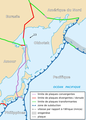 Map of the Okhotsk Plate created from the world map


Article(s): fr:Géographie du Japon
Request: Could you create a map of Japan with tectonic plates from the world map (in french), as it was done for the Okhotsk Plate ? I need on this map to see the Izu-Ogasawara Trench, the Okinawa Plate and the south of the Kuril–Kamchatka Trench (the South Kuril Islands with Iturup). Thanks! PP_Tom ( talk · contribs)
- Sorry Guys, I just found there was a french one : fr:Wikipédia:Atelier graphique/Cartes, I will ask them. PP_Tom ( talk · contribs)
Graphist opinion(s):
-
 Air India destinations

Article(s): Air India
Request: The map is showing all wrong destinations. Air India doesn't fly to the following countries marked in Red on the map - Austria, Switzerland, Pakistan, Bangladesh, Turkey, Ireland, South Korea, Indonesia, Sri Lanka, Nepal, Kenya and Tanzania. Indian Airlines flies to Nepal, Bangladesh and Sri Lanka but not Air India. Not only that, The map shows PoK as a part of Pakistan which is completely against the Republic of India... Kshitij85 ( talk) 05:35, 10 May 2010 (UTC)
Graphist opinion(s):
Article(s): 2010 IIHF World Championship
Request: Create a map for the venues section with the locations of Mannheim, Cologne, and Gelsenkirchen, similar to to this map: [1]. Slaja ( talk) 14:41, 11 May 2010 (UTC)

Article(s): German Samoa
Request: svgify, change colors... Chris (クリス • フィッチュ) ( talk) 04:56, 14 May 2010 (UTC)
Graphist opinion(s):
Article(s): trade route
Request: Anglicize spellings... Chris (クリス • フィッチュ) ( talk) 16:39, 15 May 2010 (UTC)
Graphist opinion(s):
-
 this might help make it better
 -
 Hopefully it would look like this
.png)

Article(s): Misl, Sikh Empire
Request: Could somebody combine the first two to look like the third one? I'm going through and trying to improve the Sikh military history articles but there are no good looking maps available. Thanks Profitoftruth85 ( talk) 01:02, 18 April 2010 (UTC)
Graphist opinion(s):
This is my first time posting here--hopefully I'm doing it right. The first image isn't turning up and searching on the filename doesn't result in anything. The Misl page has no map. The Sikh Empire page has a few. Is this the one that is meant: File:Punjab under Ranjit Singh1823-1839.jpg? Pfly ( talk) 01:39, 7 May 2010 (UTC)
- Hey thanks for looking at it the image can be viewed
here, the author gave permission and sent an email but its not processed yet. It was taken from a public domain book.--
Profitoftruth85 (
talk) 08:33, 11 May 2010 (UTC)
- I can do this. Matthewedwards : Chat 17:24, 17 May 2010 (UTC)

Article(s): Smoking
Request: better color gradation-greens are too close... Chris (クリス • フィッチュ) ( talk) 03:09, 18 May 2010 (UTC)
Graphist opinion(s):
-

-
 NativeForeigner
 -
 maybe this will help
 -
 TastyCakes' first attempt-Northern half of Sakhalin island has never been occupied by Japan.
.png)
.svg)


Article(s): Empire of Japan
Request: vectorize... Chris (クリス • フィッチュ) ( talk) 16:30, 23 March 2010 (UTC)
Graphist opinion(s):
![]() Request taken by NativeForeigner.
Request taken by NativeForeigner.
I have little experience with vector graphics, and a decent amount in raster, but I'm just flat out confused. I am trying to vectorize this image. I'm running into issues though. I can't seem to modify the paths to add color to the correct places in the image because of the way the points are set up. (I can't seem to connect two preexisting points) and I can't crop it. I'm following http://inkscape-forum.andreas-s.net/topic/112456 directions, but it's only cropping a tiny itsy bit, which is strange. I'm uploading the image so you can see if you can help, as I'm genuinely interested in helping if I can figure it out ;) Here is the image I've worked on... File:Empire of Japan (1868-1945).svg Regards, NativeForeigner Talk/ Contribs/ Vote! 05:56, 13 April 2010 (UTC)
- Great work so far, can someone jump in and help? --
Chris (クリス • フィッチュ) (
talk) 02:00, 15 April 2010 (UTC)
- It looks like you're just colouring in the existing countries... I think you'll have to trace out new shapes for a lot of them since they don't correspond with the existing borders. Incidentally, the borders on the existing jpg map appear to be the modern ones. If possible, would it be preferable to remove these in the new version? I can help but probably not until next week...
TastyCakes (
talk) 04:47, 15 April 2010 (UTC)
- Given a few directions on how to say modify paths, I think I would be able to do it.
NativeForeigner
Talk/
Contribs/
Vote! 04:59, 15 April 2010 (UTC)
- Oh ok, I'm not sure exactly what you're trying to do, but I usually use the "Draw Bezier curves and Straight Lines" tool. Once you've got a polygon or line you want to modify, if you select it and click F2 you'll bring up all of the points. Then you can move any of the points, turn any of the straight lines into curves by clicking and dragging or add new points (or nodes) by double clicking on the line somewhere. Is that helpful? Maybe I'm misunderstanding the problem...
TastyCakes (
talk) 06:48, 15 April 2010 (UTC)
- Ok, I've made an attempt at this. A lot of it is just eyeballed from the existing maps so please tell me if anything is wrong and needs changing. I'm not sure I've picked a very good colour for the non-Japanese territory, feel free to tinker with if you like. 21:31, 23 April 2010 (UTC)
- Oh ok, I'm not sure exactly what you're trying to do, but I usually use the "Draw Bezier curves and Straight Lines" tool. Once you've got a polygon or line you want to modify, if you select it and click F2 you'll bring up all of the points. Then you can move any of the points, turn any of the straight lines into curves by clicking and dragging or add new points (or nodes) by double clicking on the line somewhere. Is that helpful? Maybe I'm misunderstanding the problem...
TastyCakes (
talk) 06:48, 15 April 2010 (UTC)
- Given a few directions on how to say modify paths, I think I would be able to do it.
NativeForeigner
Talk/
Contribs/
Vote! 04:59, 15 April 2010 (UTC)
- It looks like you're just colouring in the existing countries... I think you'll have to trace out new shapes for a lot of them since they don't correspond with the existing borders. Incidentally, the borders on the existing jpg map appear to be the modern ones. If possible, would it be preferable to remove these in the new version? I can help but probably not until next week...
TastyCakes (
talk) 04:47, 15 April 2010 (UTC)
- That is fantastic! Can you make the blue transparent instead, and change the grey to the standard Wiki-grey of the first? --
Chris (クリス • フィッチュ) (
talk) 12:51, 24 April 2010 (UTC)
- Sure I can delete the water, but I'm not sure the regular colour will work as well as usual because if you look there are no borders in this map, so it is difficult to see lighter colours (that's why I changed it). Not sure if I'll have a minute for a while, but I'll give it a try when I do... TastyCakes ( talk) 14:20, 24 April 2010 (UTC)
- Can you also shift the perspective? It would make more sense to have the extra space be the Pacific basin to the right, not Africa to the left.-- Chris (クリス • フィッチュ) ( talk) 08:57, 15 May 2010 (UTC)
Regarding Sakhalin, its article makes it seem like Japan claimed the whole island for a long time all the way up to the Russo-Japanese war, when they settled for half. Since the map is supposed to be 1942 (not isochronous, or whatever the name is), I agree it's a mistake: only half of the island should be red. TastyCakes ( talk) 19:37, 18 May 2010 (UTC)
-
 National Parks location map

Article(s): Yoho National Park and many more.
Request: The size of Nahanni National Park Reserve needs enlarging significantly, after a huge expansion. For reference, take a look at Parks Canada's map on this page: http://www.pc.gc.ca/pn-np/nt/nahanni/ne/ne2_e.asp The map shows the original core of the park reserve, and the enlarged park reserve of today.
Missing national parks on the Wiki map include: Fathom Five, Bruce Peninsula, Lake Superior (a huge area), St. Lawrence Islands, Point Pelee, Georgian Bay Islands, Mingan Archipelago, Ukkusiksalik, and Sirmilik.
Terra Nova could use some shading in Newfoundland. Manitoulin Island needs coloring in with grey, since it is in Ontario, not the US. Lake St. Clair should be colored blue, not white.
If I can help with any references, let me know. Wish I could work on the map myself, but I don't have the technical know-how.
Yoho2001 ( talk) 05:46, 19 May 2010 (UTC)
Graphist opinion(s):
-
 Provinces of North Korea
 -
 Provinces of South Korea

.png)
Article(s): Korean reunification, Provinces of Korea
Request: Please merge the two as File:Provinces of Korea.PNG. I would have requested this on the map workshop, however this is a task that a non-cartographer could also help me with. Thanks for the help. 92.19.6.50 ( talk) 17:21, 20 May 2010 (UTC)
Graphist opinion(s):
Resolved Information
-
 Map of Teaneck, New Jersey
 -
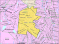 Detailed map of Wyckoff Township


Article(s): Wyckoff, New Jersey
Request: For some reason, "File:Bergen County New Jersey Incorporated and Unincorporated areas Wyckoff Highlighted.svg" redirects to "File:Bergen County New Jersey Incorporated and Unincorporated areas Teaneck Highlighted.svg", even though they're on opposite sides of the county. Could you please modify the Teaneck map to show Wyckoff Township by making Teaneck the same color as the surrounding communities and making Wyckoff Township the same red as Teaneck is in the base map, and then upload the finished version as "File:Bergen County New Jersey Incorporated and Unincorporated areas Wyckoff Highlighted.svg"? The township is currently in white in the northwestern portion of the county; the "detailed map" of the township (which I'm not asking to have modified, since it does quite well by itself) shows its borders. Nyttend ( talk) 13:46, 9 May 2010 (UTC)
Graphist opinion:

![]() Done --
ChrisRuvolo (
t) 14:41, 8 June 2010 (UTC)
Done --
ChrisRuvolo (
t) 14:41, 8 June 2010 (UTC)
-
 Example 1
 -
 Example 2
 -
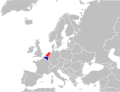
 Request: Netherlands in red and Turkey in blue


Article(s): nl:Nederlands-Turkse betrekkingen
Request: Request is very simple. A svg map of the Netherlands (red) and Turkey (blue). Upload the file in commons with the name commons:File:Nederlands-Turkse betrekkingen.svg. Randam ( talk) 09:43, 9 June 2010 (UTC)
Graphist opinion(s):
![]() Request taken by Ks0stm.
Request taken by Ks0stm.


Article(s): Wood turtle
Request: I need a distribution map that looks similar to the one provided by this exceptional reference: http://books.google.com/books?id=nNOQghYEXZMC&pg=PA251#v=onepage&q&f=false
- This would be a great help. Thanks in advance.--
NYMFan69-86 (
talk) 17:23, 13 May 2010 (UTC)
- The one on the second page
here is also good (minus all the writing and symbols).--
NYMFan69-86 (
talk) 12:58, 16 May 2010 (UTC)
- I recently made this one, however it looks pretty crummy.-- NYMFan69-86 ( talk) 01:57, 1 June 2010 (UTC)
- The one on the second page
here is also good (minus all the writing and symbols).--
NYMFan69-86 (
talk) 12:58, 16 May 2010 (UTC)
Graphist opinion:
- This one appears to be resolved? See the image on the right, which is also in the article now. It was created on June 3, so after this request was posted.
83.81.60.233 (
talk) 05:47, 30 June 2010 (UTC)
- Yes...resolved.-- NYMFan69-86 ( talk) 21:28, 30 June 2010 (UTC)
-
 Map of Hawaii outlining Mauna Loa
 -
 SVG version of that map
 -
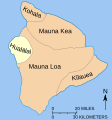 Requested map


Article(s): Hualālai, and by extension the other four volcanoes of the island as well.
Request: I'm not sure but I think this is a good target for a SVG conversion. Mainly though I am lacking an image showing the position of Haul relative the others, and the outlining of Mauna Loa in orange draws attention to it. Would like Hualālai to be outlined instead :). Thanks in advance. Res Mar 01:40, 24 June 2010 (UTC)
- I vectorized the map
Richardprins (
talk) 15:45, 10 July 2010 (UTC)
- I made one for Hualalai as well. Please make other versions for the other areas if you read this.
Richardprins (
talk) 16:04, 10 July 2010 (UTC)
- I made all the other ones as well Richardprins ( talk) 17:27, 10 July 2010 (UTC)
- I made one for Hualalai as well. Please make other versions for the other areas if you read this.
Richardprins (
talk) 16:04, 10 July 2010 (UTC)
Graphist opinion(s):
-
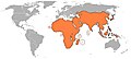
 Map of countries offering visa-free access to HKSAR passport holders

Article(s): Visa requirements for Chinese citizens of Hong Kong
Request: Please could you colour in Brunei and Niger blue, and Bangladesh, Gambia and Togo purple. Bonus bon ( talk) 15:10, 8 July 2010 (UTC)
Graphist opinion(s):
![]() Done: Coloured nations as requested.
Fallschirmjäger
✉ 21:24, 10 July 2010 (UTC)
Done: Coloured nations as requested.
Fallschirmjäger
✉ 21:24, 10 July 2010 (UTC)
-
 Original map
 -
 SVG version
 -
 PNG version
 -
 Requested version


Article(s): 2003 Afro-Asian Games
Request: Could you make a version of the map on the left, but in the style of either of the ones on the right with country borders please? There is a full list of the countries which should be highlighted in the article. Gammondog ( talk) 17:23, 8 June 2010 (UTC)
Graphist opinion(s):
![]() Request taken by Matthewedwards.
Request taken by Matthewedwards.
![]() Done Let me know if there are any errors or changes that need to be addressed. Also let me know if you need an .svg version.
Matthewedwards :
Chat 22:20, 11 July 2010 (UTC)
Done Let me know if there are any errors or changes that need to be addressed. Also let me know if you need an .svg version.
Matthewedwards :
Chat 22:20, 11 July 2010 (UTC)

Article(s): G20
Request: remove unnecessary blank space top and bottom so image displays larger... Chris (クリス • フィッチュ) ( talk) 10:19, 27 June 2010 (UTC)
Graphist opinion(s):
![]() Request taken by Matthewedwards., 00:42, 11 July 2010 (UTC)
Request taken by Matthewedwards., 00:42, 11 July 2010 (UTC)
![]() Done
Done
- Thank you!-- Chris (クリス • フィッチュ) ( talk) 07:37, 11 July 2010 (UTC)
-
 Blank map to colour :)
 -
 Example
 -
 Requested map


Article(s): Friendship Games#Participating_nations
Request: Hi! It would be great if someone (using the 1985 blank map) would create a map showing the participants of the Friendship Games (similar to example map on the right). Those are the countries to colour:
- Asia: Afghanistan, PR China, India, Japan, North Korea, Laos, Lebanon, Mongolia, Syria, Vietnam, South Yemen
- N. America: Canada, Cuba, Nicaragua, USA
- S. America: Argentina, Brazil, Colombia, Guyana, Venezuela
- Europe: Austria, Belgium, Bulgaria, Czechoslovakia, Denmark, Finland, France, East Germany, West Germany, Great Britain, Greece, Hungary, Italy, Netherlands, Norway, Poland, Portugal, Romania, Soviet Union, Spain, Sweden, Switzerland, Yugoslavia
- Africa: Algieria, Angola, Ethiopia, Madagascar, Morocco, Tanzania, Zimbabwe
Also, please mark the host countries (similar to Munich on the example map) Those are: Bulgaria, Cuba, Czechosovakia, East Germany, Hungary, North Korea, Mongolia, Poland and the Soviet Union
Thanks in advance! - ArCgon ( talk) 07:34, 30 June 2010 (UTC)
Graphist opinion(s):
![]() Request taken by Matthewedwards.: Any preference of colours used?
Matthewedwards :
Chat 22:36, 10 July 2010 (UTC)
Request taken by Matthewedwards.: Any preference of colours used?
Matthewedwards :
Chat 22:36, 10 July 2010 (UTC)
![]() Done -- see
File:1984 Friendship Games participants.png - let me know if you need an .svg version.
Matthewedwards :
Chat 21:20, 11 July 2010 (UTC)
Done -- see
File:1984 Friendship Games participants.png - let me know if you need an .svg version.
Matthewedwards :
Chat 21:20, 11 July 2010 (UTC)
-
 Map of magna frisia

Article(s): Frisian kingdom
Request: The image has a thin ghost line in it when it is rendered by wikipedia, from around the word Francia to the right. Can you please help me find what is causing it, and remove it? Richardprins ( talk) 22:34, 12 July 2010 (UTC)
- I have tried, but with no luck. Uwe Dedering ( talk) 18:57, 13 July 2010 (UTC)
- There is no problem visible when the SVG is rendered directly in Firefox, when the SVG is opened in Inkscape, or when the SVG is converted into a PNG by Inkscape and then viewed in Firefox... only when the SVG is converted to a PNG by Wikipedia and viewed (within an HTML document or independently) in Firefox. I would say that this is most likely a bug in wikipedia's use of the RSVG library that does not exist in Inkscape. The image does not pass W3C Validation , but I doubt that the errors noted there are causing the problem. Tried re-saving in Inkscape using the 'Plain SVG' encoding, but the glitch is still there when uploaded to mediawiki. Lesqual ( talk) 09:56, 19 July 2010 (UTC)
- I made an attempt as well, but couldn't find whatever is causing that. Kmusser ( talk) 14:16, 19 July 2010 (UTC)
Graphist opinion(s):
- Fixed, after three attempts. Seems to be related to the dashed boundary extending beyond the edge: the PNG renders with a thin straight line closing up what ought to be a dashed path, so I made the dashed line into a separate path and cropped the shape to the picture borders with no dashed border of its own. Deleted and merged a few other objects too. (I'm not a proper wikigrapher so I'll leave someone here to review and, if all is well, mark as "Done".) — Richardguk ( talk) 18:11, 19 July 2010 (UTC)
-
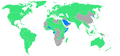
 Map depicting the final territorial boundaries following the conclusion of the Nagorno-Karabakh War.

Article(s): Kosovo independence precedent, Kosovo independence precedent
Request: Please translate this map into English. City of Destruction (The Celestial City) 23:21, 23 July 2010 (UTC)

![[1]](/info/en/?search=File:Germany_WC.png)
- Satisfactory? In territorially controversial zones like this it can be hard to use words which are descriptive without offending. I've done my best as a disinterested party, but feel free to change the wording if you feel anything has POV connotations. It took a bit of research to figure out exactly what was being portrayed in the existing maps, and I think the extra description is necessary.
Lesqual (
talk) 21:34, 24 July 2010 (UTC)
- Very satisfactory, thanks very much. The language seems very neutral and objective, so I can't see that being a problem. City of Destruction (The Celestial City) 18:01, 25 July 2010 (UTC)
Graphist opinion(s):