Parts of
Sool,
Ayn, Somalia,
Khatumo State and
Maakhir is controlled by
Puntland, an autonomous state in
Somalia, and hence de facto not controlled by Somaliland. Source Can you please fix the map? Maybe there could be light red for claimed territories and dark red for controlled territories. Thanks! --
Reepy1 (
talk) 09:23, 29 June 2013 (UTC)reply
Graphist opinion(s): That article is about the region, as well as the self-declared republic, so I think it's appropriate that the infobox map shows the whole region that the article is talking about and the article already contains a map showing the boundary dispute. Should Republic of Somaliland get split out into its own article than I think it would need the map you describe.
Kmusser (
talk) 16:43, 5 July 2013 (UTC)reply
I'd like to add a distribution map of designated protection areas for the
Japanese serow to the Japanese Serow article. -- Curly Turkey (
gobble) 06:39, 8 July 2013 (UTC)reply
page 272 of Wild Sheep and Goats and Their Relatives: Status Survey and Conservation Action Plan for Caprinae (1997; ed. David M. Shackleton) has such a map.
This map shows
Rhodesia (now
Zimbabwe) gaining independence in 1965, but that was a declaration of independence that no-one recognized, it didn't officially become independent as Zimbabwe until 1980. The unrecognized declarations of independence of
Biafra in 1967,
Somaliland in 1991 and
Azawad in 2012 aren't shown here, so Rhodesia shouldn't be either. Please change the map to show Zimbabwe turning purple in 1980 instead of 1965.
An alternative might be to mark unrecognized states in grey and purple stripes, which would apply to
Rhodesia (1965-1979),
Biafra (1967-1970),
Sahrawi (1976-present),
Somaliland (1991-present) and
Azawad (2012-2013). — Preceding
unsigned comment added by
154.50.194.126 (
talk) 09:54, 25 June 2013 (UTC)reply
Another thing to change - South Sudan independence (2011)
76.0.29.118 (
talk) 16:46, 8 July 2013 (UTC)reply
Request:
Im looking to see if anyone would help me come up with a map just like shown above for an area covering Central America, the Caribbean, the Pacific Ocean and the Atlantic Ocean up to a certain extent...
here are the desired coordinates to cover...
from the equator to 40 degrees north
from the 180 Dateline to 10 degrees west
I would like to have the image be as large as possible, wider than 5,000 px and longer than 2,000 px.
All I need in the map are the country boundaries, Islands and lakes just like in the map above.
I'll greatly appreciate your help.
Check out the conversation at
Wikipedia_talk:WikiProject_Maps#Generic_Lua_map_template, there's a template that lets you use any section of the Earth as location map - it's a different background that what you're asking for, but depending on what you're trying to show it might be usable for your purpose.
Kmusser (
talk) 02:08, 22 July 2013 (UTC)reply
Can someone make a qualitative map of current configuration of Circuito da Boavista? The map which is currently used in article shows old configuration of the circuit. Current configuration:
[1],
[2]. Note: on the 2nd image final chicane is not shown. --
Alex (
talk) 16:47, 25 July 2013 (UTC)reply
The map showing the territorial evolution of the British Empire is historically incorrect. Singapore gained independence from the UK in 1963, yet this map seems to suggest that it didn't gain independence until someetime beetween 1974 and 2007, so would someone please fix that. Another thing, Brunei gained independence from the UK in 1984, but on this map, it looks like it gained independence sometime between 1959 and 1974, so that needs fixing as well. Then there's Malaysia, the part of it known as Malaya gained independence in 1957, the map got that right, but the rest of it the UK didn't let go of until 1963, as Sarawak and North Borneo, yet the red of the British Empire vanishes from those areas in the 1959 frame, when it should vanish in the 1974 frame, so please fix that too. Additionally, someone needs to fix the border of British Somaliland in the 1914, 1919, 1938, and 1945 frames, based on the map of British Somaliland. The border of Newfoundland is also incorrect in the frames at 1938 and 1945, so please fix that based on the map of the Dominion of Newfoundland. One final thing, add the border of South Sudan to this map. — Preceding
unsigned comment added by
154.50.194.126 (
talk •
contribs) 12:43, 23 May 2013 (UTC)reply
Article(s): Every article these maps are already on.
Request:
Draw in the border between Sudan and South Sudan on all these maps please. — Preceding
unsigned comment added by
154.50.194.126 (
talk •
contribs) 11:29, 12 June 2013 (UTC)reply
Article(s): Several articles related to Ilam province and its counties.
Darreh Shahr,
Ilam, etc.
Request:
This map is going to show Ilam province of Iran with all counties. Something like the map for Alberta province ,File:Canada Alberta location map 2.svg. — Preceding
unsigned comment added by
Milad.olad (
talk •
contribs) 21:02, 28 July 2013 (UTC)reply
Request:
I recently created an article about what countries steroids are legal and not legal in. Current sources should be listed there. But I think the page needs a map describing the legality of steroids in different countries. I just want something simple that can be added to and edited over time. — Preceding
unsigned comment added by
Cole132132 (
talk •
contribs) 13:39, 30 July 2013 (UTC)reply
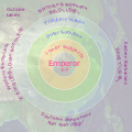
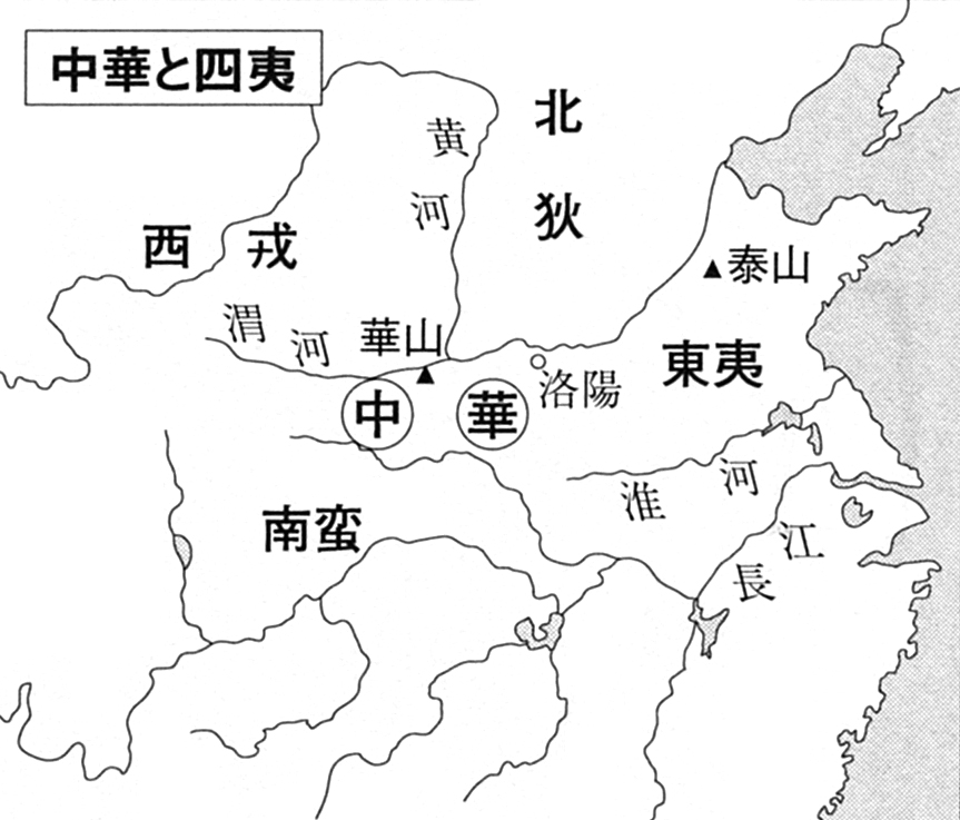
Several articles have an inaccurate Siyi 四夷 "Four Barbarians" map that WP editors have criticized. The most recent
Talk:Xirong (people)#Twice-deleted map discussion, in which I was involved, resulted in this request for an improved map showing China bordered by the Siyi. The ideal would be something similar with this "中華と四夷" map from a
Japanese book and
academic website. Both the above "Tianxia" and "Sinocentrism" files are complicated by unnecessary circles (reflecting another "five zone" worldview). If anyone is willing to create this map, I will be glad to help with the Chinese characters or anything else. --
Keahapana (
talk) 23:34, 17 July 2013 (UTC)reply
In regards to those external links, the labels for Dongyi, Nanman, Xirong, Beidi should definitely be spread way more outward (as a clearer "directional" labels outside the Chinese heartland) and the later aggregate term Zhonghua (中華) should be replaced by Huaxia (華夏), placed ideally in the Yellow River basin near
Wei River (basically approx. where Xi'an stands) if we must overlay it on a map. --
Cold Season (
talk) 10:27, 18 July 2013 (UTC)reply
Question: Do you want the grey area included?
► Philg88 ◄talk 15:29, 23 August 2013 (UTC)reply
I'm thinking it should be a basic city map with the area(s) concerned simply outlined and shaded - If you "cut out" the surrounding areas the map will lose its context - how would anyone then be able to tell what part of the city this is. Do you have access to a "base" street map of Kimberley? The traffic circles (roundabouts) and sports fields in the source image make it easy to match to an existing street map.
Roger (Dodger67) (
talk) 16:53, 24 August 2013 (UTC)reply
Sorry, but I can't identify the location from
OpenStreetMap, which can serve as the base map. What is the name of the road running NW - SE with the two traffic circles? Thanks!
► Philg88 ◄talk 06:36, 25 August 2013 (UTC)reply
My mistake, sorry! Only the south-eastern circle currently exists - the north-western one doesn't yet.
The SE circle is the intersection of Dalham, Memorial and Oliver Roads.
The NW circle (will be) the intersection of Dalham Rd, Bultfontein Rd, Scanlan St, Bishops Ave, and Lyndhurst Rd. The street connecting them is thus Dalham Rd. The distinctive shape of the Civic Centre area (the northern part of the campus on the "source" image) is just north of the future NWern circle. Hope this explanation is adequate. Thanks
Roger (Dodger67) (
talk) 08:40, 25 August 2013 (UTC)reply
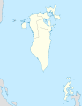
I know this is a long shot but I plan on expanding the Dilmun article above and a map is definitely needed for the article. The source I have is an
official government source, the map is located in page 17. Can anyone help me with this? --
Droodkin (
talk) 20:56, 30 August 2013 (UTC)reply
I am working on Æthelstan, the first king of England, who ruled between 924 and 939, and I think a map would be very helpful to making the article clear. I have revised the map in Sarah Foot's biography at
[3] to include more places mentioned in the article (those I could fit in) and delete some less important ones. My revised version is at
[4]. Thanks very much if anyone can help with this. (Note: I have provided a link to copies of the files but I do not think I can upload them to Commons as I think they are copyright in their present form. Please advise if this is not the best way to proceed.)
Dudley Miles (
talk) 13:22, 10 August 2013 (UTC)reply
Graphist opinion(s):
Request taken by --
Ikonact (
talk) 14:11, 31 August 2013 (UTC).reply
Here is a first draft proposal. Please let me know your comments. I have followed your map. I have some doubts about the visibility when integrated in an article. The names of the towns are a bit small. May be more information may be added. --
Ikonact (
talk) 18:01, 31 August 2013 (UTC)reply
I think that's magnificent, great work. I learnt a few things about text visibility at small sizes working on an overlay version of an image for the Sistine Chapel of all things. If you like, I can play with that in a derivative copy and see if I can do anything - not promising it will help or look encyclopedic, just willing to experiment. Begoontalk 18:21, 31 August 2013 (UTC)reply
Many thanks. That's brilliant. Some points of detail:
First a couple of errors in my map, with apologies. I think I got the position of Deheubarth a bit wrong. It should be more in the south east corner of Wales. See
[5]. Also I think it might be better to leave out CUMBRIANS. They are not mentioned in the article and it is disputed whether they ever had a kingdom separate from Strathclyde.
There are typos spelling Sussex, Shaftesbury and Beverley.
Burnswark and Brinsworth (which you kept from Foot's map) could be deleted. They are fairly obscure and not mentioned in the article. Amounderness is also not mentioned. It might be worth adding it in the article, but if it is kept in the map, it should not be the same size font as the Welsh kingdoms - it is just an area which Æthelstan gave to the Archbishop of York.
It would be helpful to have Kingston in if it fits. It is where Æthelstan was crowned! Also Eamont (above Cumbrians), the site of an important meeting. Possibly also Northumbria, which is mentioned in the article, although it no longer existed as a kingdom by Æthelstan's time.
There are 9 places mentioned in the article which I could not fit in. I did not list them as I did not want to give the wikigraphist too much work, but as you have said more information might be added they are
Frome,
Cirencester,
Lichfield,
Grately,
Faversham, Thunderfield (in
Horley),
Wells,
Milton Abbas and
Muchelney. However, they would probably make the map too crowded.
Not sure what to say to Begoon's kind offer - I think I had better leave it between the two of you to decide.
Many thanks again for the excellent map. I am going on holiday to Italy for a week on Monday so will be off wiki.
Dudley Miles (
talk) 20:00, 31 August 2013 (UTC)reply
I certainly don't want to intrude, and
Ikonact's map is superb, so I won't do anything unless anyone thinks it might help. There are just some "unobvious" things you can do with drop shadows etc... which seem tiny but make a big legibility difference in small type. It may not even help here, depending on the final map, but just offering support if needed, which it probably isn't. Ignore me. Begoontalk 20:18, 31 August 2013 (UTC)reply
OK, I have updated the map following Dudley Miles' recommendations. I have not added the 9 places as they really make the map too crowded but if you wish I can do it. I will be happy if Begoon can improve the legibility as it will be useful when the map is integrated in the article. You can try with a derivative copy and see what it gives. Thanks --
Ikonact (
talk) 21:03, 31 August 2013 (UTC)reply
That all looks fine, and ready to go into the article. If only I could do that sort of work! I will wait to see whether Begoon can improve legibility further before I use it. Thanks a million.
Dudley Miles (
talk) 21:59, 31 August 2013 (UTC)reply
Your map is fantastic, Ikonact, and I hope you won't be upset if I can't improve by tinkering (I'm just a tinkerer by nature), but I'll have a play anyway in the next day or so - possibly it won't help - we'll see. Thanks for helping out here - we really do need the help from skilled editors like you.
. Don't wait for me, Dudley, if it can be improved (which is only a maybe) it won't matter if it's already included in the article, and it should be right away. Begoontalk 22:12, 31 August 2013 (UTC)reply
I had a play, but aside from just bolding or increasing font size, I couldn't really do anything. Drop shadows just look naff and blurry, and my idea of white type outlined with black didn't look good or help either. At the end of the day it's just going to be small, I guess. Sorry. The file gives some rendering errors (blue horizontal lines etc) when I play with it in Inkscape, and Illustrator won't load it without losing the clipping mask, which didn't help - but I doubt my ideas were much use. I thought I might be able to make a difference, but sadly nothing I was happy with. Apologies for suggesting I could help when I evidently can't... Begoontalk 06:39, 1 September 2013 (UTC)reply
A side comment, which makes me uneasy with all early maps of Britain: The modern coastline is shown. However, the coastline at the time was noticeably different in places - notably the
Isle of Thanet. Getting that sorted is a much more complex exercise, not really needed for this request, but working something out would be good.--
Nilfanion (
talk) 23:26, 31 August 2013 (UTC)reply
I agree and if I have any reliable geographical data for this period I could try to improve my map. I cannot rely only on text descriptions. The only map I ever saw is
this one. Do you have any source about the coastline in the past? Thank you. --
Ikonact (
talk) 13:51, 1 September 2013 (UTC)reply
I have now added the map to the article. Many thanks again.
Dudley Miles (
talk) 16:53, 1 September 2013 (UTC)reply
@
Ikonact There's an old UK coastline map
here (edit) ... and a better one
here. I am currently working on a layered SVG map of Roman Britain (400 AD) that may be of use to you for the coastline when it's finished. Best,
► Philg88 ◄talk 18:55, 1 September 2013 (UTC)reply
I have added the old coastline using
this file. I think now this should be OK. May be I have to add a legend to explain what the different colours mean. Thank you --
Ikonact (
talk) 21:05, 2 September 2013 (UTC)reply
It's sometimes better to do the legends in the article, like the one in the infobox at
Ostrich, under the "range map", just for legibility when the image is scaled. If I do that I also put the same wikicode on the image description page. Begoontalk 12:59, 3 September 2013 (UTC)reply
A map is required to show the boundaries of the Old Town and New Town of Edinburgh. These boundaries are defined by
conservation area boundaries, whcih can be downloaded from the
Historic Scotland data website. Ideally the boundaries of the two conservation areas would be shown on one of the above base maps (I prefer the first - the second may be closer in but too detailed?), to illustrate the position and extent of the Old Town and New Town within the city. Thanks,
Jonathan Oldenbuck (
talk) 12:37, 5 September 2013 (UTC)reply
Graphist opinion(s):
Request taken. I think the best way to do this is to import the Historic Scotland data into OpenStreetMap (OSM) (non-trivial but doable) then create a new SVG and update the Commons map with the new boundary highlighted. This will take a few days so please bear with me.
► Philg88 ◄talk 07:15, 6 September 2013 (UTC)reply
I was just playing with this, and QGIS is what I was going to use, working with a download of the OSM file for Scotland from geofabrik.de, because it won't let me import Edinburgh in-toto with the OpenStreetMap plugin - too many nodes. I'll probably carry on doing it just for fun, but since I've never exported svg files with OSM data from QGIS - first time playing with it, don't know what I'll get. Begoontalk 07:52, 6 September 2013 (UTC)reply
Well, I get garbage
. I'll have to install PostGIS and other stuff and do a bit of learning - so it'll take me all of your few days, but I'll treat it as an exercise. Labelling objects and styles is going to be the key - but it will take me a while. Philg88, I'm sure you'll get something better and quicker - but I'll persevere anyway just as a learning thing.
. Begoontalk 09:50, 6 September 2013 (UTC)reply
Is it possible to re-create the map with English names rather than French names?
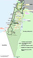
Israeli controlled zones on June 1948
This map was inserted into an article, but it was deleted since it is a French language map. (the
Diff page ). It it was re-inserted but it would be better to have it translated to English. Thanks.
Ykantor (
talk) 14:43, 7 September 2013 (UTC)reply
Can anyone re-do this map
[6], so it can be added to Commons?
Cavann (
talk) 20:20, 2 September 2013 (UTC)reply
Graphist opinion(s):
Request taken by
Ikonact (
talk) 22:41, 16 September 2013 (UTC).reply
Here is a first draft. Could you please check it? --
Ikonact (
talk) 19:01, 17 September 2013 (UTC)reply
Awesome~~ Background done with your script, semantic layers done in Inkscape right ? :)
Yug(talk) 10:03, 18 September 2013 (UTC)reply
This time it was easier :) Background done with
Sémhur's map. I have removed the relief and cropped a little bit. Semantic layers is done in Inkscape ;) I could have used my script for the geographical data, but this was not necessary as a map exists already.--
Ikonact (
talk) 12:19, 18 September 2013 (UTC)reply
Looking great Ikonact!
Cavann (
talk) 19:53, 19 September 2013 (UTC)reply
Done Thank you. Happy to have helped. --
Ikonact (
talk) 05:26, 21 September 2013 (UTC)reply
Sacred City of Anuradhapura
Resolved
– requester indicated resolved - image in use Begoontalk 16:27, 21 September 2013 (UTC)reply
Request: I took a photo of an information board showing the historic sites of this unesco world heritage place. As there is no FOP in Sri Lanka i thought someone might be interested to retrace that map, which i could mail. --
Cherubino (
talk) 20:07, 17 September 2013 (UTC)reply
Graphist opinion(s):
Comment
I don't know what an "FOP" is but if you mean email you can do that through my user page. Alternatively, I have found a 1909 and a 1938 map of Anurdhapura, which could be the basis for a new map. Please let me know if that works for you. Best,
► Philg88 ◄talk 04:00, 18 September 2013 (UTC)reply
Freedom of panorama. It's a copyright thing - another little set of rules...
And I don't think you can send attachments via
Special:EmailUser (the userpage link) unless you reply and give your actual address. You probably found the b/w line maps at lankapura.com (can't link as it's "blacklisted" for some reason...) which I looked at earlier when I did a quick search? Begoontalk 04:15, 18 September 2013 (UTC)reply
Thanks Begoon
, Cherubino has emailed me via my user page and I replied via gmail asking for his pic. Thanks for the heads up on FOP and you're right as to the source of the maps - the 1909 one is now out of copyright and might be useful too. Best,
► Philg88 ◄talk 08:27, 18 September 2013 (UTC)reply
The map describes
Abhayagiri vihāra with Twin Ponds, Smadhi Buddha, Moonstone Site, Abhayagiri Dagoba, so it's only the northern part of ancient Anuradhapura as shown on this map
[7] --
Cherubino (
talk) 09:25, 19 September 2013 (UTC)reply
Article(s):Manama and other related articles (neighborhoods).
Request:
I'm
working on boosting the Manama page to GA and hopefully FA status, and a map of the old neighbourhoods of the city is definitely necessary in the history and urbanism parts of the article. My source is a renown historian who conveniently has a
map of Manama in 1926 (pages 74-75 as a single map), which should provide something to work on. Whether it should be an SVG or PNG file, I don't know but any map would be really swell.--
Droodkin (
talk) 21:43, 11 September 2013 (UTC)reply
.svg)


 English "Tianxia" version
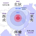 Simpler "Sinocentrism" version

 Done Please add comments
here
► Philg88 ◄
Done Please add comments
here
► Philg88 ◄
 talk 17:36, 25 August 2013 (UTC)
 Question: Do you want the grey area included?
► Philg88 ◄
Question: Do you want the grey area included?
► Philg88 ◄
 The map to use on.
 Map showing the ancient burial mounds of Northern Bahrain


 British Islands in 10th century - first proposal

 Request taken by --
Ikonact (
talk) 14:11, 31 August 2013 (UTC).
Request taken by --
Ikonact (
talk) 14:11, 31 August 2013 (UTC).
 . Don't wait for me, Dudley, if it can be improved (which is only a maybe) it won't matter if it's already included in the article, and it should be right away.
Begoon
talk 22:12, 31 August 2013 (UTC)
. Don't wait for me, Dudley, if it can be improved (which is only a maybe) it won't matter if it's already included in the article, and it should be right away.
Begoon
talk 22:12, 31 August 2013 (UTC)
 This should be the base map
 Or possibly this one?

 New map
 Israeli controlled zones on June 1948
 English version
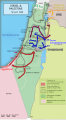 Version française
 中文版本
中文版本


 Not done Sorry, but this is a page for map requests not article edits/corrections. Best,
► Philg88 ◄
Not done Sorry, but this is a page for map requests not article edits/corrections. Best,
► Philg88 ◄
 proposal


![[1]](http://www.circuitodaboavista.com/fotos/gca/mapacircuito1182p_1361207910.jpg)
![[2]](http://www.motorsport-total.com/wtcc/saison/zoom.html?sgl=http://www.motorsport-total.com/wtcc/saison/strecken/porto.jpg)
![[5]](https://commons.wikimedia.org/wiki/File:Medieval_Wales.JPG)
![[6]](http://www.utexas.edu/courses/classicalarch/images1/Hittiterulemap.jpg)