Stale Information
-
 Location of Iran
 -
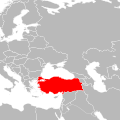 Location of Turkey
 -
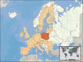 Poland here in dark red


Article(s): Potential Great Powers, possibly Iran, Turkey, and Poland pages also.
Request: Can you make them into orthographic maps (if possible). I'm planning to create a page called Potential Great Powers, and I'm trying to get all the basics down on my page that you'll see by clicking my link before I create the page. If you can, thanks. Deavenger ( talk) 02:00, 11 February 2009 (UTC)
Graphist opinion:
Resolved Information
-
No map currently available on wiki
-
 1st try by Yug.

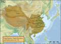
Article(s): Tang Dynasty
Request: Hello graphists, I'm reading the Cambridge history of China, vol.3, and there are a really complete map of the Tang Dynasty in 742. The map is display in the page 403, and it would be interesting to use it to produce the map of the Empire area, together with the provinces borders. I found a link : on books.google.com. A map would be welcome~ Requester (talk) 12:07, 3 January 2009 (UTC)
Graphist opinion:
- Ok, I'm interested by this one. I will provide something soon. Yug (talk) 10:67, 5 January 2009 (UTC)
- O.O ! Great ! far better than what I expected. Thanks so much !!!! I put it into the article ! Thanks ! Requester (talk) 9:41, 21 January 2009 (UTC)
-
Presidential voting shifts from the 2004 election to the 2008 election
-

-


Article(s): United States Presidential Election, 2008
Request: Make another map just like it so it's allowed to be put up in the article. Frightwolf ( talk) 16:54, 9 February 2009 (UTC)
Graphist opinion: We'd need the original source data to make a non-free version. That's generally available on each individual county board of election web site, but I'm not about to collate them all. Kmusser ( talk) 17:10, 9 February 2009 (UTC)
-
http://elections.nytimes.com/2008/results/president/map.html Do you mean something like that? --
Frightwolf (
talk) 19:01, 9 February 2009 (UTC)
- That's copyrighted.
Kmusser (
talk) 19:28, 9 February 2009 (UTC)
- I don't mean use that (that's the problem I'm having, anyway), but if the NYT is accurate, couldn't we make a similar map in the same vein? If not, then because of the sheer amount of work it would take, would it be possible to find a way to use the NYT map instead? --
Frightwolf (
talk) 19:44, 9 February 2009 (UTC)
- We could make a similar map, but would need to go to the county results, ideally as reported by the counties themselves rather than the media as the media often don't bother to wait for final numbers to publish and don't usually go back to update themselves (note the lack of Alaska data, and I'd imagine MN doesn't reflect the recounts) - I also wouldn't put it past the NYT to deliberately mis-color a county as a copyright trap. Unfortunately "it would take a lot of work to replace" isn't exactly a valid fair use rationale. However, that said, since responding I did find county level results in a non-graphical format for 2008 that would be usable to create a map if we're ok with media reported numbers (bottom of
http://www-personal.umich.edu/~mejn/election/2008/), if we can get the same for 2004 it might not be as hard as I initially thought.
Kmusser (
talk) 20:26, 9 February 2009 (UTC)
- Ah, your talk about the NYT mis-coloring a county is a great point. I believe dictionaries have made up some words and definitions as a copyright trap, as well. Good call. As far as the county results, I believe it'd definitely be useful. Do you think you and even a few other editors may be able to work on it at some point? My photo program is pretty primitive. I tried just making a state results map and it just doesn't do the job, unfortunately. --
Frightwolf (
talk) 20:49, 9 February 2009 (UTC)
- I can turn a spreadsheet into a map, would just need the '04 data in a spreadsheet to map the change.
Kmusser (
talk) 21:24, 9 February 2009 (UTC)
- Here's something I found:
http://www.usatoday.com/news/politicselections/vote2004/PresidentialByCounty.aspx?oi=P&rti=G&tf=l&sp=AZ Does this help? On the right, you just need to go President by County and select which state, and they give you a county-by-county run-down for each state. Not as great as just one spreadsheet, but a pretty good resource nonetheless. --
Frightwolf (
talk) 22:23, 9 February 2009 (UTC)
- Data obtained! I'll see what I can do, if I don't have something for you today it'll be next week sometime.
Kmusser (
talk) 18:07, 11 February 2009 (UTC)
- Thanks! I appreciate it very much! -- Frightwolf ( talk) 00:26, 12 February 2009 (UTC)
- Data obtained! I'll see what I can do, if I don't have something for you today it'll be next week sometime.
Kmusser (
talk) 18:07, 11 February 2009 (UTC)
- Here's something I found:
http://www.usatoday.com/news/politicselections/vote2004/PresidentialByCounty.aspx?oi=P&rti=G&tf=l&sp=AZ Does this help? On the right, you just need to go President by County and select which state, and they give you a county-by-county run-down for each state. Not as great as just one spreadsheet, but a pretty good resource nonetheless. --
Frightwolf (
talk) 22:23, 9 February 2009 (UTC)
- I can turn a spreadsheet into a map, would just need the '04 data in a spreadsheet to map the change.
Kmusser (
talk) 21:24, 9 February 2009 (UTC)
- Ah, your talk about the NYT mis-coloring a county is a great point. I believe dictionaries have made up some words and definitions as a copyright trap, as well. Good call. As far as the county results, I believe it'd definitely be useful. Do you think you and even a few other editors may be able to work on it at some point? My photo program is pretty primitive. I tried just making a state results map and it just doesn't do the job, unfortunately. --
Frightwolf (
talk) 20:49, 9 February 2009 (UTC)
- We could make a similar map, but would need to go to the county results, ideally as reported by the counties themselves rather than the media as the media often don't bother to wait for final numbers to publish and don't usually go back to update themselves (note the lack of Alaska data, and I'd imagine MN doesn't reflect the recounts) - I also wouldn't put it past the NYT to deliberately mis-color a county as a copyright trap. Unfortunately "it would take a lot of work to replace" isn't exactly a valid fair use rationale. However, that said, since responding I did find county level results in a non-graphical format for 2008 that would be usable to create a map if we're ok with media reported numbers (bottom of
http://www-personal.umich.edu/~mejn/election/2008/), if we can get the same for 2004 it might not be as hard as I initially thought.
Kmusser (
talk) 20:26, 9 February 2009 (UTC)
- I don't mean use that (that's the problem I'm having, anyway), but if the NYT is accurate, couldn't we make a similar map in the same vein? If not, then because of the sheer amount of work it would take, would it be possible to find a way to use the NYT map instead? --
Frightwolf (
talk) 19:44, 9 February 2009 (UTC)
- That's copyrighted.
Kmusser (
talk) 19:28, 9 February 2009 (UTC)
- Done! I need some help from someone that knows SVG better to determine why Alaska and Hawaii aren't showing up (they show up fine in Inkscape) and possibly reduce the massive file size. Kmusser ( talk) 15:21, 19 February 2009 (UTC)
- This looks great! I really appreciate the work you put into it. I'm not too familiar with the programs to know why Hawaii and Alaska aren't showing up, but I still could put it up for now and we'll just update it when it shows up. Does that sound all right? -- Frightwolf ( talk) 17:34, 19 February 2009 (UTC)
Article(s): Afghanistan; Demography of Afghanistan
Request: Basically, I want these 3 maps to look more "professional" and cleaned up. All three are sourced. Additional maps, such as this one or this one, can be used as a help. Thank you. If you need any further sources, please let me know. Tājik ( talk) 02:12, 19 February 2009 (UTC)
Graphist opinion:
- The first step would be to do a SVG version of the districts map. I'll try to create one from
[1] which should be a free (
commons:template:PD-MapLibrary) source for reliable vector data. /
Lokal
_
Profil 20:56, 19 February 2009 (UTC)
- Yes, that's great. Thank you very much.
Tājik (
talk) 21:09, 19 February 2009 (UTC)
- Drat. After having converted it and getting ready to upload it I discovered that this particular map comes from another source and isn't PD. Have now updated PD-MapLibrary to make others aware of this. To bad but at least Africa maps and Central America maps are free. /
Lokal
_
Profil 21:32, 19 February 2009 (UTC)
- Sent them an e-mail about a possible change from cc-by-nc-sa to cc-by-sa but I wouldn't keep any hopes up. /
Lokal
_
Profil 21:49, 19 February 2009 (UTC)
- Hmmm ... thank you anyway. Is there any other way? Tājik ( talk) 22:21, 19 February 2009 (UTC)
- There is
File:Afghanistan districts.png on commons which might make a suitable basemap.
Kmusser (
talk) 02:43, 20 February 2009 (UTC)
- Is the data from
MapInfo Professional (which is proprietary) is that just a program for combining different data? BTW. got an out of office reply to the e-mail so any answer would be deleayed until next week. /
Lokal
_
Profil 19:52, 21 February 2009 (UTC)
- Yes, MapInfo is just the software, not the data source - though User:Rarelibra doesn't give his data source, public domain sources for administrative boundaries aren't hard to come by, so I don't have reason to doubt the PD claim. Kmusser ( talk) 01:28, 22 February 2009 (UTC)
- Is the data from
MapInfo Professional (which is proprietary) is that just a program for combining different data? BTW. got an out of office reply to the e-mail so any answer would be deleayed until next week. /
Lokal
_
Profil 19:52, 21 February 2009 (UTC)
- Sent them an e-mail about a possible change from cc-by-nc-sa to cc-by-sa but I wouldn't keep any hopes up. /
Lokal
_
Profil 21:49, 19 February 2009 (UTC)
- Drat. After having converted it and getting ready to upload it I discovered that this particular map comes from another source and isn't PD. Have now updated PD-MapLibrary to make others aware of this. To bad but at least Africa maps and Central America maps are free. /
Lokal
_
Profil 21:32, 19 February 2009 (UTC)
- Yes, that's great. Thank you very much.
Tājik (
talk) 21:09, 19 February 2009 (UTC)
- Ok. The Afghanistan map I created might be free anyway. since the data originally comes from USGS. I'll just doublecheck to make sure. /
Lokal
_
Profil 16:59, 24 February 2009 (UTC)
- Thank you very much for your efforts. How long - do you think - will it take to finish the maps? :-)
Tājik (
talk) 13:52, 25 February 2009 (UTC)
- Once the svg basis is cleared it shouldn't take long. I'll upload the svg basis but hold on a few days in case I get a reply on my e-mails. /
Lokal
_
Profil 19:26, 25 February 2009 (UTC)
- Almost done with ethnicity map. Only problem is that the png map Includes a district which in the svg is two districts. I'll need to investigate which is right. /
Lokal
_
Profil 15:44, 1 March 2009 (UTC)
- Ethnicity map done. I've however discovered that the districts in the svg map aren't the most up to date... not much one can do though. / Lokal _ Profil
- Thank you! The maps look good. Do not worry about the security map. Do you think you can insert a legend into the maps? Explaining the colors? That would be great!
Tājik (
talk) 13:35, 2 March 2009 (UTC)
-
Lokal put a legend in the image description, it's usually better to copy the legend into the caption on the page that you're going to use the map and keep the map itself language independent, see
United Nations Regional Groups as an example in use.
Kmusser (
talk) 13:59, 2 March 2009 (UTC)
- That sounds good. Thank you. Tājik ( talk) 14:06, 2 March 2009 (UTC)
- Hi, I discovered a small mistake in the map regarding ethnic groups. Two districts that are Tajik and Hazara in majority are shown as Pashtun. You see them by comparing the new map with the old one. It's in the
Ghazni area.
Tājik (
talk) 20:13, 2 March 2009 (UTC)
- I know. The problem is that whilst they are two districts in the png map they are one district in the svg. Apparently there has been quite a lot of reorganisation in that area so I extrapolated the colour based on
Ghazni_Province#Demographics_and_geography. Interestingly enough it was neither of the colours in the png which dominated. /
Lokal
_
Profil 01:30, 3 March 2009 (UTC)
- OK, fair enough. That's a good explanation, and it should not be such a big problem. Just one last point: Hazara is spelled with a "z" only, not with "zh". ;-) But thank you very much, anyway! Tājik ( talk) 03:14, 3 March 2009 (UTC)
- Additional corrections: indeed, both former districts (Jaghatu and Bahrami Shahid) were put together to form the
new district "Jaghatu". According to
official numbers from Afghanistan, Hazaras are 73% of this new district (see also
this official PDF). So, the color of that district should be yellow.
Tājik (
talk) 03:34, 3 March 2009 (UTC)
- Thanks. Map and legends have been updated. It seems as though there has been a lot of admin changes in that area since (according to Ghazni_Province that disterict no longer exists. That's not a problem for this map though. / Lokal _ Profil 22:13, 3 March 2009 (UTC)
- Thank you man. Now everything is fine. I will copy the maps into the relevant articles. Take care. Tājik ( talk) 23:10, 3 March 2009 (UTC)
- I know. The problem is that whilst they are two districts in the png map they are one district in the svg. Apparently there has been quite a lot of reorganisation in that area so I extrapolated the colour based on
Ghazni_Province#Demographics_and_geography. Interestingly enough it was neither of the colours in the png which dominated. /
Lokal
_
Profil 01:30, 3 March 2009 (UTC)
-
Lokal put a legend in the image description, it's usually better to copy the legend into the caption on the page that you're going to use the map and keep the map itself language independent, see
United Nations Regional Groups as an example in use.
Kmusser (
talk) 13:59, 2 March 2009 (UTC)
- Almost done with ethnicity map. Only problem is that the png map Includes a district which in the svg is two districts. I'll need to investigate which is right. /
Lokal
_
Profil 15:44, 1 March 2009 (UTC)
- Once the svg basis is cleared it shouldn't take long. I'll upload the svg basis but hold on a few days in case I get a reply on my e-mails. /
Lokal
_
Profil 19:26, 25 February 2009 (UTC)
- Thank you very much for your efforts. How long - do you think - will it take to finish the maps? :-)
Tājik (
talk) 13:52, 25 February 2009 (UTC)
-
PNG
-
 SVG
SVG

Article(s): List of countries by motor vehicle production Retrieved from " http://en.wikipedia.org/wiki/File:Autoproduction2.PNG"]]
Request: Make into SVG please. Also, remove the unnecessary flags. Zoo Fari 00:18, 21 February 2009 (UTC)
Graphist opinion:
- I'll give this a shot. / Lokal _ Profil 19:53, 21 February 2009 (UTC)
- Thank you, I have updated the article and added the 2005/2000 as well. Thanks again! Zoo Fari 02:41, 24 February 2009 (UTC)

Article(s): Union State
Request: Wikify map-white oceans, grey land in non-relevant areas... Chris (クリス • フィッチュ) ( talk) 09:45, 16 February 2009 (UTC)
Graphist opinion:
- The recommended Wikipedia map colours are here. It looks to me like this map, and all it's sister works are already in the proper style. Inductiveload ( talk) 11:15, 16 February 2009 (UTC)
-
 Map displaying settlements of Zaprešić and city limits of the city and surrounding municipalities
 -
 SVG version


Article(s): Zaprešić
Request: Although I'm proud of my fiddling with Photoshop and scans of existing maps, I'm planning to have the article where this map appears featured and I'd like it to look as professional as possible. Since I currently can't modify the map to accord to our mapping guidelines (yellow on orange background, etc.; the kind of a map you usually see on high-profile articles) without losing much information about the borders in the process, and I really suck at SVGs, I'm asking someone to do the job for me. Hopefully, it shouldn't be too hard. Admiral Norton ( talk) 23:11, 25 February 2009 (UTC)
Graphist opinion:
I can do a quick trace of it, but I can't promise the borders will be 100% the same. It's tricky tracing lines that squiggle all over and the convert to SVG tool in Inkscape is worthless. vıd ıoman 23:54, 25 February 2009 (UTC)
- That's not an issue for me, I understand it can't be done perfectly given software and human limitations and I don't expect it to be pristine. BTW, the thick border down right is a county border and I believe it should be emphasized somehow (you don't have to make it that way if the regulations say otherwise, I don't know them). Admiral Norton ( talk) 17:52, 26 February 2009 (UTC)
- Two things: The top left had a large brown area, I interpreted that as a county division and drew it as such but if it is wrong I can correct it. Also, I made the land on the other side of county borders grey so that Zagreb county could be orange, allowing Zaprešić to be yellow. If you think the other counties should just be orange let me know. Also let me know if the numbers appear properly (aren't overlapping boundaries or each other). vıd ıoman 02:20, 1 March 2009 (UTC)
-
 Original PNG Map of the RoF & Mts. Mayon, Krakatau, St. Helens, Pinatubo, and Garibaldi
 -
 this could be used as a clearer base map
 -
 base SVG image, created using WDB data


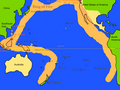
Article(s): Pacific Ring of Fire
Request: Convert into SVG and fine-tune it, please. - BlueCaper ( talk) 18:48, 4 February 2009 (UTC)
Graphist opinion:
- I've made a base image, using WDB data with a resolution of 1 degree. It needs text and fault lines added.
gringer (
talk) 23:57, 10 February 2009 (UTC)
- Added labels and stuff. Inductiveload ( talk) 17:19, 11 February 2009 (UTC)
- OK, added volcanos. Is that done? − Inductiveload ( talk) 23:24, 13 February 2009 (UTC)
-

-
 How about this map?
Article(s): {{ WikiProject Korea}}
Request: This should be fairly straightforward. What I need is a version of the above map which makes South Korea (the light green bits) more visible when reduced to that size. I'm not too fussy on how it's done; if it's any help, maps like this have areas highlighted in pink, or another option would be to use colours similar to this map. Thanks in advance! PC78 ( talk) 02:27, 9 February 2009 (UTC)
Graphist opinion: Does the location map work for you? On such a small size you won't see much detail anyway. Where do you need such a tiny map? bamse ( talk) 11:03, 9 February 2009 (UTC)
- Actually that's not bad (must have missed that one). I need it for the project banner, as an icon for the South Korean geography work group. PC78 ( talk) 11:29, 9 February 2009 (UTC)

Article(s): Area codes 385 and 801
Request: I need a map that outlines the area code overlay of 385 and 801. A map is located here C L — 00:43, 2 March 2009 (UTC)
Graphist opinion: How does this look? Kmusser ( talk) 19:53, 3 March 2009 (UTC)
- That's great! Perhaps just add 385/801 and 435 labels in the appropriate areas and that'll be it. Thanks - C L — 22:29, 3 March 2009 (UTC)

Article(s): Vevo
Request: Please vectorize the logo of the new Google/Universal Music Group music video service Vevo. Not sure if it's worth keeping the tag line (it's a small font and difficult to see in the article). Thanks! ~ ωαdεstεr16 «talk stalk» 03:15, 10 April 2009 (UTC)
Graphist opinion: Logo is copyrighted, we can't vectorise per the resolution clause of WP:FU. — Vanderdecken∴ ∫ ξ φ 17:40, 10 April 2009 (UTC)
 Not done Since it is copyrighted, why not leave it as it is? It is best to leave them without modification. After all, it is in PNG format.
Zoo
Fari 18:06, 10 April 2009 (UTC)
Not done Since it is copyrighted, why not leave it as it is? It is best to leave them without modification. After all, it is in PNG format.
Zoo
Fari 18:06, 10 April 2009 (UTC)
- Logos are done here all the time. For example, a few in 2009:
this,
this, and
this. Most logos for large, notable companies are in SVG and there has not been a problem. This argument came up before in the
January archive and the supporters of vectorizing seem to be in the right. And obviously after an SVG is uploaded, I would request the immediate deletion of the png. Also, one could argue (though I don't feel confident enough to do so) that this logo is PD due to the fact that
it's only a typeface. When doing a quick search function in
WP:FU and
WP:LOGO, nowhere do the strings "vector" or "SVG" exist, so it's apparently not that big of a deal. ~
ωαdεstεr16
«talk
stalk» 18:32, 10 April 2009 (UTC)
- Personally I think logo PNGs should not be vectorized. I usually encourage others not to vectorize. There is nothing wrong with leaving a logo as PNG, and it is a huge risk to vectorize, but I guess that is not up to me. Still eligible for vectorization...
Zoo
Fari 18:44, 10 April 2009 (UTC)
- How do you see it as a risk? Do you mean to Wikipedia or the uploader? I think this is little more than paranoia but that's just my opinion. ~ ωαdεstεr16 «talk stalk» 18:52, 10 April 2009 (UTC)
- Personally I think logo PNGs should not be vectorized. I usually encourage others not to vectorize. There is nothing wrong with leaving a logo as PNG, and it is a huge risk to vectorize, but I guess that is not up to me. Still eligible for vectorization...
Zoo
Fari 18:44, 10 April 2009 (UTC)
- I don't have a problem with vectorising PNG logos as such, but if too much effort is required to vectorise (e.g. guessing the intent of antialiasing from a very low-resolution image), I don't think it's worth it. This logo in particular should be easy and, as a disclaimer in the PNG file page says, "This logo only consists of typefaces, individual words, slogans, or simple geometric shapes. These are not eligible for copyright alone because they are not original enough, and thus the logo is considered to be in the public domain."
gringer (
talk) 23:38, 10 April 2009 (UTC)
- Yea, I didn't place those tags there, but I had a gut feeling that that was the case. Didn't feel confident enough to make that call though. But I'd appreciate a vectorization. It's gonna go svg eventually anyway; this product will most likely become very popular once it's up and running. ~ ωαdεstεr16 «talk stalk» 17:56, 11 April 2009 (UTC)
- Logos are done here all the time. For example, a few in 2009:
this,
this, and
this. Most logos for large, notable companies are in SVG and there has not been a problem. This argument came up before in the
January archive and the supporters of vectorizing seem to be in the right. And obviously after an SVG is uploaded, I would request the immediate deletion of the png. Also, one could argue (though I don't feel confident enough to do so) that this logo is PD due to the fact that
it's only a typeface. When doing a quick search function in
WP:FU and
WP:LOGO, nowhere do the strings "vector" or "SVG" exist, so it's apparently not that big of a deal. ~
ωαdεstεr16
«talk
stalk» 18:32, 10 April 2009 (UTC)
I'm sorry, but this logo is definitely copyrighted; it not eligible to be in the PD. If anyone disagrees, please let me know. In regards to vectorizing it, I would say just wait until they come out with an official SVG logo. --Pbroks13 talk? 23:59, 11 April 2009 (UTC)
- I don't buy this. Like I said previously, this will eventually be vectorized and I haven't seen the case where we just wait for (and depend on) the hosting company to create and distribute said file. ~
ωαdεstεr16
«talk
stalk» 02:43, 12 April 2009 (UTC)
- Okay, well I made a vector version. What do you think?
--Pbroks13
talk? 16:57, 12 April 2009 (UTC)
- It looks good. The font on the subline seems to be off. Maybe it should just be excluded? The SM is only on the VEVO part, so maybe we should only consider those four letters the actual logo. ~ ωαdεstεr16 «talk stalk» 19:11, 12 April 2009 (UTC)
- Okay, well I made a vector version. What do you think?
--Pbroks13
talk? 16:57, 12 April 2009 (UTC)
76.117.247.55 ( talk) 17:43, 12 April 2009 (UTC)


Articels: IPCC
Request: SVGify if possible, if not, recreate as a PNG to prevent the compression artifacts, such as are currently there. 76.117.247.55 ( talk) 05:37, 11 April 2009 (UTC)
Oppinion: How's this? File:Ipcclogo.svg --Pbroks13 talk? 17:12, 12 April 2009 (UTC)
- Looks good and I see you've already marked it VVA. 76.117.247.55 ( talk) 17:43, 12 April 2009 (UTC)== Map of Dapeng Peninsula ==

Article(s):
Dapeng Peninsula
Request: Do something with them/Create according to the provided sources a map of the peninsula Helanhuaren ( talk) 09:55, 11 March 2009 (UTC)
Graphist opinion: Did up a quick map, hopefully that works. Kmusser ( talk) 17:51, 18 March 2009 (UTC)
-
 Current PNG
 -
 (SVG in German)
 -
 SVG in English


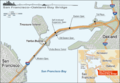
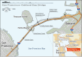
Article(s): San Francisco – Oakland Bay Bridge
Request: Could someone make this PNG an SVG? Thanks in advance, Spencer T♦ Nominate! 14:59, 16 March 2009 (UTC)
Graphist opinion: The image description of the German svg says: Please do not use this SVG graphic within Wikipedia articles! Use the enclosed PNG version instead. This SVG file is solely a source for re-utilization, editing or printing purposes. Why do you need an SVG version of the very good png map? Did you contact the mapmaker Alexrk, who should already have an English vector version on his harddisk? bamse ( talk) 00:32, 17 March 2009 (UTC)
SVG version already exists, the linked SVG file has both English and German layers and is the source for the PNG - if there is a mistake in the PNG make the correction in the SVG file and output a new PNG file for display purposes, otherwise I don't see anything to do here. Kmusser ( talk) 20:12, 17 March 2009 (UTC)
- I made three changes, but in the PNG: A miles/km (both) scale is there, the "proposed" eastern span replacement is no longer proposed so that needs to be removed. In addition, the dashed lines for the eastern span should be made solid. See Wikipedia:Featured picture candidates/San Francisco-Oakland Bay Bridge for related discussion about this. I have not contacted Alexrk, and will do so now. Spencer T♦ Nominate! 00:42, 18 March 2009 (UTC)
- I don't know how to work with SVGs, so I came here for assistance. Thanks,
Spencer
T♦
Nominate! 00:42, 18 March 2009 (UTC)
- OK, I applied the corrections you made to the PNG version to the SVG version as well.
Kmusser (
talk) 15:07, 18 March 2009 (UTC)
- I have uploaded the English layer of the SVG as a separate file, as File:SFOBB map en.svg. However, the English layer still has some issues that were corrected in the German layer: Broken fonts in the highway shields, the Oakland label not centered, and a missing "Francisco". Could you correct these, please? Thanks, Spencer T♦ Nominate! 19:44, 18 March 2009 (UTC)
- OK, I applied the corrections you made to the PNG version to the SVG version as well.
Kmusser (
talk) 15:07, 18 March 2009 (UTC)

Article(s): Ping Chau
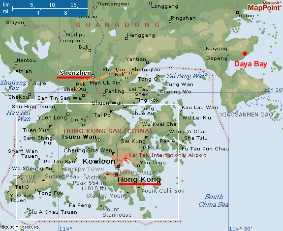
Request: Do something with them/Create according to the provided sources a map of the Hong Kong island Ping Chau in the area between Dapeng and Sai Kung. It lays in Tai Pang Wan/Mirs Bay, in the north east of Hong Kong. Its very near Dapeng Peninsula and seems like a banana. Helanhuaren ( talk) 10:52, 25 March 2009 (UTC)
Graphist opinion: I made a locator map for it, unfortunately the SVG locator maps currently being used for Hong Kong don't go out that far, so I based this on the older PNG locator maps, if anyone else wants to convert it to SVG feel free to do so. You could also probably use the map I made for Dapeng, it isn't labeled on there but it is clearly visible. Kmusser ( talk) 13:39, 25 March 2009 (UTC)

Article(s): Dapeng
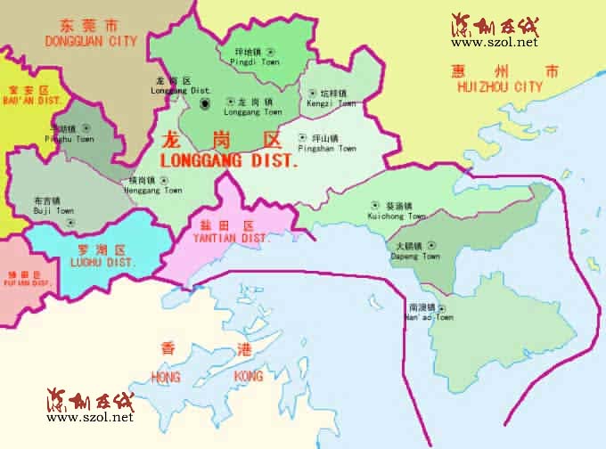
Request: Do something with them/Create according to the provided sources a map of Dapeng subdistrict in Longgang Helanhuaren ( talk) 08:59, 1 April 2009 (UTC)
Graphist opinion: I just added a dot to the Longgang District map. Also added the standard Chinese locator map to the article. Kmusser ( talk) 15:09, 1 April 2009 (UTC)
-
 updated SVG

Article(s): FIFA
Request: I originally posted this at Wikipedia talk:WikiProject Maps and they told me to come here, so I'm just going to copy what I wrote there:
I was looking at various images regarding international football, and I discovered that while some of the images used (such as File:World Map FIFA.svg and File:Qualifying countries of 2002 FIFA World Cup.svg were in SVG format, neither of them respected the Home Nations' borders as they should. While the PNG images that exist do the same, as they are based on File:BlankMap-World-UK.png, which does should the borders correctly. Is there any effort to create an SVG version of this image, or modify the existing SVG world map to show the borders? I started trying to do it myself, but I felt like I was taking a hacksaw to it when it required much more precision than I could offer. Also, am I even asking this in the right place?
-- iTocapa iChat 19:47, 18 March 2009 (UTC)
Graphist opinion: OK, I did File:World Map FIFA.svg, you should be able to copy/paste my update to other SVG files that used that same basemap. Kmusser ( talk) 16:51, 9 April 2009 (UTC)

Article(s): London International Airport
Request: Hopefully this one is fairly easy. I need a map like Karl's airport destination maps ( example), but for YXU. All data regarding the destinations should be there in the article. Thanks! — paranomiahappy harry's high club 22:18, 13 April 2009 (UTC)
Graphist opinion: Will do, should have it for you in a day or two. Kmusser ( talk) 23:36, 13 April 2009 (UTC)
- Awesome, thanks. — paranomiahappy harry's high club 00:12, 14 April 2009 (UTC)
-
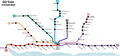 GO Train system map
 -
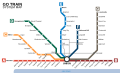 SVG (Subject to stupid rendering errors)
 -
 PNG, recommended you use this.


Article(s): Lincolnville GO Station, Lisgar GO Station
Request: I need a couple of things done: first, it needs to be SVGified. Then, it'd be great if you could add Lincolnville GO Station and Lisgar GO Station in their correct places (you can use their articles and Google Maps for info about their approximate location). Thanks! Paranomia ( talk) 00:47, 25 April 2009 (UTC)
Graphist opinion:
- How is
this? (Ignore the extra white space on the sides.)
vıd
ıoman 07:42, 25 April 2009 (UTC)
- That's great! But you've got "Rutherford" spelt wrong, as well as "Milliken". Also, do you have an SVG of that? Thanks again!
Paranomia (
talk) 12:41, 25 April 2009 (UTC)
- It was actually already an SVG and I just noticed it (
File:GOTrain.svg) but I have my own version anyway and since it is up to date we will use this until the network changes again, then use whichever is updated first.
vıd
ıoman 14:20, 25 April 2009 (UTC)
- OK, thanks. I didn't see that SVG.
75.119.234.240 ( talk) 19:26, 25 April 2009 (UTC)Paranomia ( talk) 19:27, 25 April 2009 (UTC)
- OK, thanks. I didn't see that SVG.
- It was actually already an SVG and I just noticed it (
File:GOTrain.svg) but I have my own version anyway and since it is up to date we will use this until the network changes again, then use whichever is updated first.
vıd
ıoman 14:20, 25 April 2009 (UTC)
- That's great! But you've got "Rutherford" spelt wrong, as well as "Milliken". Also, do you have an SVG of that? Thanks again!
Paranomia (
talk) 12:41, 25 April 2009 (UTC)