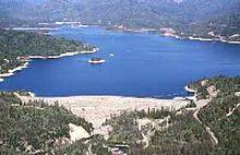
| Whiskeytown Dam | |
|---|---|
 | |
| Location | Shasta County, California, United States |
| Coordinates | 40°35′55.8″N 122°32′22.3″W / 40.598833°N 122.539528°W |
| Construction began | 1960 |
| Opening date | 1963 |
| Owner(s) | U.S. Bureau of Reclamation |
| Dam and spillways | |
| Type of dam | Embankment |
| Impounds | Clear Creek |
| Height | 282 ft (86 m) [1] |
| Length | 1,228 ft (374 m) [1] |
| Spillway type | Glory-hole |
| Spillway capacity | 28,650 cu ft/s (811 m3/s) [2] |
| Reservoir | |
| Creates | Whiskeytown Lake |
| Total capacity | 241,100 acre-feet (297,400 dam3) [3] |
| Catchment area | 202.5 sq mi (524 km2) [2] |
| Surface area | 3,220 acres (1,300 ha) [4] |
| Power Station | |
| Commission date | 1964 [5] |
| Hydraulic head | 566 ft (173 m) [5] |
| Turbines | 2x 90 MW at Spring Creek Powerplant [5] |
| Installed capacity | 180 MW [5] |
| Annual generation | 274,224,000 KWh [5] |
Whiskeytown Dam (officially Clair A. Hill Whiskeytown Dam) [6] is an earthfill dam on Clear Creek, a tributary of the Sacramento River of northern California in the United States.

The dam is located about 6 miles (9.7 km) west of Redding, and impounds Whiskeytown Lake on the southern flank of the Trinity Mountains. The dam is 282 feet (86 m) high, with a storage capacity of 241,100 acre-feet (297,400 dam3) of water. [3]
History
The dam was one of the first units built of the Trinity River Division of the Central Valley Project, a federal water project intended to provide irrigation water to the eponymous Central Valley. Construction started in August 1960 with clearing operations around the dam site, and excavations for the spillway and outlet tunnels began in October. By late 1961, over one-half of the dam embankment was complete. The dam was topped out on February 7, 1963, and the reservoir was allowed to begin filling. On September 28, it was dedicated by President John F. Kennedy to a crowd of more than 10,000 people. [6] [7]
Water diverted from the Trinity River through the 11-mile (18 km) Clear Creek Tunnel is stored behind Whiskeytown Dam before it is released into the Sacramento River. The water is released to the Sacramento through lower Clear Creek and the Spring Creek Tunnel. The latter furnishes water to the 180 megawatt (MW) Spring Creek Powerplant, which generates about 274 million kilowatt hours (KWh) annually. [5]
In addition, there is a 3.5 MW Power Plant at the base of Whiskeytown dam built in 1986 by the city of Redding. [8] This power plant generates power through the flows that were previously released down Clear Creek through the project's river outlets.
The lake and dam are named after the Gold Rush camp of Whiskeytown, which was submerged in 1963 with the filling of the new reservoir. [7]
See also
- Lewiston Dam
- List of dams and reservoirs in California
- List of United States Bureau of Reclamation dams
- Spring Creek Dam
- Trinity Dam
- Whiskeytown-Shasta-Trinity National Recreation Area
- California Historical Landmarks in Shasta County
- Reading's Bar
References
- ^ a b "Whiskeytown Dam Dimensions". Shasta/Trinity River Division Project. U.S. Bureau of Reclamation. 2009-06-04. Retrieved 2012-06-05.
- ^ a b "Whiskeytown Dam Hydraulics & Hydrology". Shasta/Trinity River Division Project. U.S. Bureau of Reclamation. 2009-06-04. Retrieved 2012-06-05.
- ^ a b "Shasta/Trinity River Division Project". Central Valley Project. U.S. Bureau of Reclamation. 2011-04-21. Retrieved 2012-06-05.
- ^ "Whiskeytown Dam (USBR) (WHI)". California Data Exchange Center. California Department of Water Resources. Retrieved 2012-06-05.
- ^ a b c d e f "Spring Creek Powerplant". Shasta/Trinity River Division Project. U.S. Bureau of Reclamation. 2009-05-13. Retrieved 2012-06-05.
- ^ a b Stene, Eric A. (1996). "Trinity Division: Central Valley Project" (PDF). Bureau of Reclamation History Program. U.S. Bureau of Reclamation. Retrieved 2012-06-05.
- ^ a b "The Story of Whiskeytown" (PDF). U.S. National Park Service. Retrieved 2012-06-05.
- ^ "REU's History". City of Redding. Retrieved 2022-06-02.