| Site of Special Scientific Interest | |
 | |
| Location | Berkshire |
|---|---|
| Grid reference | SU 353 761 [1] |
| Coordinates | 51°28′59″N 1°29′24″W / 51.483°N 1.49°W |
| Interest | Biological |
| Area | 14.1 hectares (35 acres) [1] |
| Notification | 1990 [1] |
| Location map | Magic Map |
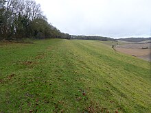
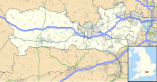
Westfield Farm Chalk Bank is a 14.1-hectare (35-acre) biological Site of Special Scientific Interest west of East Garston in Berkshire. [1] [2]
Geography
The site is lowland Calcareous grassland [3] The bank is North facing. [4] There is access by a footpath from Newbury Road.
Flora
The site has the following Flora: [4]
- Bromus erectus
- Brachypodium pinnatum
- Lolium perenne
- Cynosurus cristatus
- Scabiosa columbaria
- Linum catharticum
- Thymus praecox
- Cirsium acaule
- Carex flacca
- Gentianella amarella
- Knautia arvensis
- Primula veris
- Anthyllis vulneraria
- Galium verum
- Briza media
- Ononis repens
- Sanguisorba minor
- Plantago media
- Campanula glomerata
- Koeleria macrantha
- Trifolium medium
- Dactylorhiza fuchsii
- Listera ovata
- Anacamptis pyramidalis
- Coeloglossum viride
- Platanthera chlorantha
References
Wikimedia Commons has media related to
Westfield Farm Chalk Bank.
- ^ a b c d "Designated Sites View: Westfield Farm Chalk Bank". Sites of Special Scientific Interest. Natural England. Retrieved 14 January 2020.
- ^ "Map of Westfield Farm Chalk Bank". Sites of Special Scientific Interest. Natural England. Retrieved 14 January 2020.
- ^ "Condition of SSSI Units for Site WESTFIELD FARM CHALK BANK". Natural england. Retrieved 15 February 2017.
- ^ a b "Westfield Farm Chalk Bank citation" (PDF). Sites of Special Scientific Interest. Natural England. Retrieved 14 January 2020.
