West Marion Historic District | |

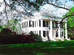
Reverie, one of the contributing buildings | |
| Location | Roughly bounded by W. Lafayette St., Washington St., Murfree Ave., College St. and Margin St., Marion, Alabama |
|---|---|
| Coordinates | 32°37′34″N 87°19′20″W / 32.62611°N 87.32222°W |
| Area | 200 acres (81 ha) |
| Architectural style | Colonial Revival, Bungalow/Craftsman, Greek Revival |
| NRHP reference No. | 92001844 [1] |
| Added to NRHP | April 22, 1993 |
The West Marion Historic District is a historic district in the city of Marion, Alabama. The historic district is bounded by West Lafayette, Washington, College, Margin streets, and Murfree Avenue. It features examples of Colonial Revival, Craftsman, Greek Revival, and regional vernacular architecture. It spans 200 acres (81 ha) and contains 108 contributing properties. One contributing building of special significance is Reverie. [2] The district was placed on the National Register of Historic Places on April 22, 1993. [1]
References
- ^ a b "National Register Information System". National Register of Historic Places. National Park Service. July 9, 2010.
- ^ Mansell, Jeff; Melanie A. Betz (June 30, 1992). "West Marion Historic District". National Register of Historic Places Registration Form. National Park Service. Archived (PDF) from the original on March 11, 2014. Retrieved March 11, 2014. See also: "Accompanying photos". Archived (PDF) from the original on March 11, 2014. Retrieved March 11, 2014.
Categories:
- National Register of Historic Places in Perry County, Alabama
- Historic districts in Perry County, Alabama
- Colonial Revival architecture in Alabama
- Greek Revival architecture in Alabama
- Historic districts on the National Register of Historic Places in Alabama
- Marion, Alabama
- Alabama Registered Historic Place stubs


