This article needs to be updated. (October 2020) |
| Waterplace Park | |
|---|---|
 | |
|
| |
| Location | Providence, Rhode Island |
| Coordinates | 41°49′25″N 71°24′27″W / 41.8237113°N 71.4075563°W |
| Created | 1994 |
Waterplace Park is an urban park situated along the Woonasquatucket River in downtown Providence, Rhode Island at the original site of the Great Salt Cove. Finished in 1994, Waterplace Park is connected to 3/4 mile of cobblestone-paved pedestrian walkways along the waterfront known as Riverwalk. Venice-styled Pedestrian bridges cross the river. Most of Riverwalk is below street level and automotive traffic. Waterplace Park and Riverwalk together are host to Providence's popular summertime Waterfire events, a series of bonfires lit on the river accompanied by classical and world music.
-
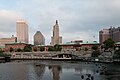 Waterplace Park in 2009
 -
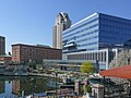 Waterplace Park in 2008.
 -
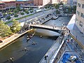 The Woonasquatucket River forms the center of the park


History
Waterplace Park was part of Providence's River Relocation Project, which began in the 1980s. [1]
See also
References
- ^ "Waterplace Park". www.goprovidence.com. Retrieved 2023-10-13.
- Woodward, Wm Mckenzie. Guide to Providence Architecture. 1st ed. 2003: United States. p 305.
| Parks in Providence, Rhode Island |
|---|
|
Burnside Park · India Point Park · Prospect Terrace Park · Roger Williams National Memorial · Roger Williams Park · Waterplace Park |
|
| This Rhode Island state location article is a stub. You can help Wikipedia by expanding it. |