| Site of Special Scientific Interest | |
 | |
| Location | Northamptonshire |
|---|---|
| Grid reference | SP 965 986 [1] |
| Interest | Biological |
| Area | 4.4 hectares [1] |
| Notification | 1983 [1] |
| Location map | Magic Map |
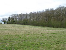
Wakerley Spinney is a 4.4-hectare (11-acre) biological Site of Special Scientific Interest west of King's Cliffe in Northamptonshire. [1] [2]
This is a remnant of the ancient Royal Forest of Rockingham, and it has broadleaved woodland and semi-natural grassland. The most common trees are pedunculate oak, ash, sycamore and downy birch. Locally uncommon flowering plants include woodruff, violet helleborine and fly orchid. [3]
The site is private land with no public access.
References
- ^ a b c d "Designated Sites View: Wakerley Spinney". Sites of Special Scientific Interest. Natural England. Retrieved 4 April 2017.
- ^ "Map of Wakerley Spinney". Sites of Special Scientific Interest. Natural England. Retrieved 4 April 2017.
- ^ "Wakerley Spinney citation" (PDF). Sites of Special Scientific Interest. Natural England. Retrieved 4 April 2017.
Wikimedia Commons has media related to
Wakerley Spinney.