Włoszczowa | |
|---|---|
 Market Square in Włoszczowa | |
 Coat of arms | |
 Włoszczowa | |
| Coordinates: 50°51′15″N 19°58′1″E / 50.85417°N 19.96694°E | |
| Country | |
| Voivodeship | Świętokrzyskie |
| County | Włoszczowa |
| Gmina | Włoszczowa |
| Government | |
| • Mayor | Grzegorz Dziubek ( PSL) |
| Area | |
| • Total | 30.17 km2 (11.65 sq mi) |
| Elevation | 240 m (790 ft) |
| Population (2012) | |
| • Total | 10,657 |
| • Density | 350/km2 (910/sq mi) |
| Time zone | UTC+1 ( CET) |
| • Summer ( DST) | UTC+2 ( CEST) |
| Postal code | 29-100 |
| Area code | +48 41 |
| Car plates | TLW |
| Website | http://wloszczowa.pl/ |
Włoszczowa [vwɔˈʂt͡ʂɔva] ⓘ is a town in southern Poland, in Świętokrzyskie Voivodeship, about 50 kilometres (31 miles) west of Kielce. It is the capital of Włoszczowa County. Population is 10,657 (2010). [1] Włoszczowa lies in historic Lesser Poland. The town has the area of 30 km2 (11 sq miles).
History
| Year | Pop. | ±% |
|---|---|---|
| 1921 | 5,479 | — |
| 1931 | 6,900 | +25.9% |
| 2010 | 10,657 | +54.4% |
| Source: [2] [1] | ||
Włoszczowa was first mentioned in 1154, when Prince Henry of Sandomierz handed the village known then as Vloszcova to the Sovereign Military Order of Malta monks. It received its town charter in 1539, when King Zygmunt Stary handed the document to the starosta of Chęciny, Hieronim Szafraniec. The town remained the property of the Szafraniec family until the late 18th century. In the Kingdom of Poland and the Polish–Lithuanian Commonwealth, Włoszczowa was part of the Sandomierz Voivodeship in the Lesser Poland Province.
After the Partitions of Poland, it belonged to Russian-controlled Congress Poland (1815 - 1918). In the Second Polish Republic, Włoszczowa belonged to Kielce Voivodeship. It had a large Jewish population, which made 50% of its population in 1925. Almost all Włoszczowa's Jews were murdered by the Germans in the Holocaust.
Sights
Among points of interest there are remains of a 12th-century gord, with traces of a moat, and ruins of the Szafraniec family castle (16th century). Furthermore, there is a 17th-century parish church, and the 16th-century urban layout of the streets.
Transport
Włoszczowa is a junction of regional roads nr 786, nr 742, and 785. Włoszczowa has two rail stations: PKP Włoszczowa (on the Kielce - Częstochowa route), and PKP Włoszczowa Północ (Włoszczowa North) (on the Central Rail Line).
Twin towns
Włoszczowa is twinned with:
-
 Illintsi, Ukraine
 -
 Le Passage, Lot-et-Garonne, France
-
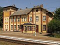 Train station
 -
 Church of the Assumption
 -
 Partyzantów Street
 -
 Pendolino at the Włoszczowa - North train station


References
- ^ a b Stan i struktura ludności oraz ruch naturalny w przekroju terytorialnym w 2010 r. (PDF) (in Polish). Warszawa: Główny Urząd Statystyczny. 2011. p. 98. Archived from the original (PDF) on 13 November 2011.
- ^ Wiadomości Statystyczne Głównego Urzędu Statystycznego (in Polish). Vol. X. Warszawa: Główny Urząd Statystyczny. 1932. p. 195.
External links
| Seat |  | |
|---|---|---|
| Urban-rural gmina | ||
| Rural gminas | ||
| Town and seat | | |
|---|---|---|
| Villages | ||
| International | |
|---|---|
| National | |