Vorra | |
|---|---|
 Vorra in
Hersbrucker Alb | |
 Coat of arms | |
Location of Vorra within Nürnberger Land district 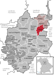 | |
 Vorra  Vorra | |
| Coordinates: 49°32′N 11°30′E / 49.533°N 11.500°E | |
| Country | Germany |
| State | Bavaria |
| Admin. region | Mittelfranken |
| District | Nürnberger Land |
| Municipal assoc. | Velden (Pegnitz) |
| Subdivisions | 4 Gemeindeteile |
| Government | |
| • Mayor (2023–29) | Bernd Müller [1] ( CSU) |
| Area | |
| • Total | 22.08 km2 (8.53 sq mi) |
| Elevation | 365 m (1,198 ft) |
| Population (2022-12-31)
[2] | |
| • Total | 1,745 |
| • Density | 79/km2 (200/sq mi) |
| Time zone | UTC+01:00 ( CET) |
| • Summer ( DST) | UTC+02:00 ( CEST) |
| Postal codes | 91247 |
| Dialling codes | 09152 |
| Vehicle registration | LAU, ESB, HEB, N, PEG |
| Website | www.vorra-mfr.de |
Vorra is a municipality in the district of Nürnberger Land in Bavaria in Germany.
Notable inhabitants
- Johann Friedrich Stoy (1700–1760), Evangelical theologian
- Hans Vogel (1881–1945), politician ( SPD)
References
- ^ Liste der ersten Bürgermeister/Oberbürgermeister in kreisangehörigen Gemeinden, Bayerisches Landesamt für Statistik. Retrieved 5 September 2023.
- ^ Genesis Online-Datenbank des Bayerischen Landesamtes für Statistik Tabelle 12411-003r Fortschreibung des Bevölkerungsstandes: Gemeinden, Stichtag (Einwohnerzahlen auf Grundlage des Zensus 2011) ( Hilfe dazu).
| International | |
|---|---|
| National | |
|
| This Nürnberger Land location article is a stub. You can help Wikipedia by expanding it. |