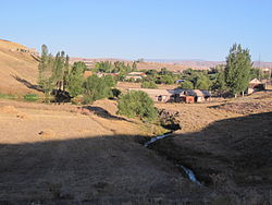
40°48′34″N 43°45′10″E / 40.80944°N 43.75278°E
Voghji
Ողջի | |
|---|---|
 | |
| Coordinates: 40°48′34″N 43°45′10″E / 40.80944°N 43.75278°E | |
| Country | Armenia |
| Province | Shirak |
| Municipality | Amasia |
| Population (2001) | |
| • Total | 602 |
| Time zone | UTC+4 |
Voghji ( Armenian: Ողջի) is a village in the Amasia Municipality of the Shirak Province of Armenia. [1] [2] [3]
In 1988-1989, Azerbaijanis of the village moved to Azerbaijan, leading to Armenians from the Ninotsminda region of Georgia, the Spitak earthquake zone, and Azerbaijan to settle in the village. [4]
Demographics
According to 1912 publication of Kavkazskiy kalendar, there was a mainly Karapapakh population of 930 in the village of Okhchoglu of the Kars Okrug of the Kars Oblast. [5]
The population of the village since 1886 is as follows: [6]
| Year | Population |
|---|---|
| 1886 | 551 |
| 1897 | 747 |
| 1926 | 799 |
| 1939 | 1,093 |
| 1959 | 1,032 |
| 1970 | 1,412 |
| 1979 | 1,504 |
| 1989 | 110 |
| 2001 | 602 |
| 2004 | 631 |
Gallery
-
Village before exodus of Azerbaijanis
-
Azerbaijani pupil of Okhchuoghlu school, 1984
References
- ^ USSR Report. POLITICAL AND SOCIOLOGICAL AFFAIRS.
- ^ Бакинские ведомости. «ЦИВИЛИЗОВАННЫЙ» АРАмагеддон
- ^ Felix Tsertisivadze. THE FORGOTTEN GENOCIDE. New York. 2005. ISBN 978-0-9741857-4-3. p. 48
- ^ "Ողջի" (PDF). shirak.mtad.am. Retrieved 14 February 2021.
- ^ Кавказский календарь на 1912 год [Caucasian calendar for 1912] (in Russian) (67th ed.). Tiflis: Tipografiya kantselyarii Ye.I.V. na Kavkaze, kazenny dom. 1912. Archived from the original on 11 December 2021.
- ^ Հայաստանի Հանրապետության բնակավայրերի բառարան [Republic of Armenia settlements dictionary] (PDF) (in Armenian). Yerevan: Cadastre Committee of the Republic of Armenia. 2008. Archived from the original (PDF) on 11 March 2018.
- Voghji, Shirak at GEOnet Names Server
- Report of the results of the 2001 Armenian Census, Statistical Committee of Armenia


