Villaluenga del Rosario, Spain | |
|---|---|
|
Flag  Seal | |
.png) Location of Villaluenga del Rosario | |
| Coordinates: 36°42′N 5°23′W / 36.700°N 5.383°W | |
| Municipality | Cádiz |
| Government | |
| • Mayor | Alfonso Carlos Moscoso |
| Area | |
| • Total | 57 km2 (22 sq mi) |
| • Land | 57 km2 (22 sq mi) |
| • Water | 0.00 km2 (0.00 sq mi) |
| Population (2018)
[1] | |
| • Total | 438 |
| • Density | 7.7/km2 (20/sq mi) |
| Time zone | UTC+1 ( CET) |
| • Summer ( DST) | UTC+2 ( CEST) |
| Website | villaluengadelrosario.es |
Villaluenga del Rosario is a village located in the province of Cádiz, Spain. According to the 2005 census, the city has a population of 481 inhabitants. It is located down Navazo Alto mountain, within the Sierra de Grazalema Natural Park. The village is famous for its payoyo cheese, first produced in 1996 from the milk of the local, endangered Payoya goat. [2]
Demographics
| Year | Pop. | ±% |
|---|---|---|
| 1999 | 447 | — |
| 2000 | 440 | −1.6% |
| 2001 | 414 | −5.9% |
| 2002 | 455 | +9.9% |
| 2003 | 449 | −1.3% |
| 2004 | 473 | +5.3% |
| 2005 | 481 | +1.7% |
| Source: INE (Spain) | ||
Gallery
-
 View of Villaluenga del Rosario when climbing to Navazo Alto
 -
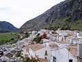 Villaluenga del Rosario
 -
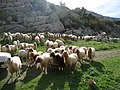 Sheep crossing a road


References
- ^ Municipal Register of Spain 2018. National Statistics Institute.
- ^ Ruiz, Olatz (24 February 2013). "El queso payoyo, el tesoro de la sierra de Grazalema". El Mundo (in Spanish). Retrieved 2 October 2019.
External links
Wikimedia Commons has media related to
Villaluenga del Rosario.
- Villaluenga del Rosario - Sistema de Información Multiterritorial de Andalucía
| International | |
|---|---|
| National | |
|
| This article about a location in Andalusia, Spain, is a stub. You can help Wikipedia by expanding it. |