Van Vorst Park Historic District (Boundary Increase) | |
 | |
   | |
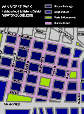
| Location | Roughly bounded by Mercer, Wayne, Montgomery, Grove, Bright, Varick and Monmouth Streets, Jersey City, New Jersey |
|---|---|
| Coordinates | 40°43′7″N 74°2′53″W / 40.71861°N 74.04806°W |
| Area | 7.7 acres (3.1 ha) |
| Architectural style | Late 19th And 20th Century Revivals |
| NRHP reference No. | 84000084 [1] |
| NJRHP No. | 1540 [2] |
| Significant dates | |
| Added to NRHP | October 11, 1984 |
| Designated NJRHP | August 2, 1978 |
Van Vorst Park is a neighborhood in the Historic Downtown of Jersey City, Hudson County, New Jersey, centered on a park sharing the same name. The neighborhood is located west of Paulus Hook and Marin Boulevard, north of Grand Street, east of the Turnpike Extension, and south of The Village and Christopher Columbus Drive. Much of it is included in the Van Vorst Park Historical District. [3]
The park was a centerpiece of Van Vorst Township, a township that existed in Hudson County from 1841 to 1851. Van Vorst was incorporated as a township by an Act of the New Jersey Legislature on April 12, 1841, from portions of Bergen Township. On March 18, 1851, Van Vorst Township was annexed by Jersey City. [4]
The name Van Vorst comes from a prominent family in the area, the first of which arrived in the 1630s as superintendent of the patroonship Pavonia, the earliest European settlement on the west bank of the Hudson River in the province of New Netherland. His homestead at Harsimus, plus others at Communipaw, Paulus Hook, Minakwa, Pamrapo were later incorporated into Bergen. His namesake and eighth generation descendant, Cornelius Van Vorst, was the twelfth Mayor of Jersey City serving from 1860 to 1862. [5] [6]
Like Harsimus Cove and Hamilton Park to the north and Bergen-Lafayette to the southwest, the neighborhood contains nineteenth century rowhouses and brownstones. [7] It is home to the Jersey City Free Public Library, James J. Ferris High School (named for the Jersey City citizen who laid the foundation of the Hudson and Manhattan Railroad Powerhouse with his firm Stillman, Delehanty and Ferris), [8] [9] and Old Colony Shopping Plaza. Landmarks include Barrow Mansion and Dixon Mills.
The Grove Street PATH station is located nearby to the north and is the Jersey Avenue (HBLR station) to the south.
Park

Van Vorst Park is a two-acre city park bounded by Barrow Street on the east, Montgomery Street on the north, Jersey Avenue on the west and York Street on the south. The park was renovated in 1999 at a cost of two million dollars with money raised by the Friends of Van Vorst Park. [10]
See also
- List of neighborhoods in Jersey City, New Jersey
- List of Registered Historic Places in Hudson County, New Jersey
- Pavonia, New Netherland
- Odonyms in Hudson County, New Jersey
- Grace Church Van Vorst
Images
-
 View northeast to JC Main Library
 -
 Heppenheimer Mansion at Montgomery and Jersey
 -
 Madison on the Van Vorst Park at York and Barrow
 -
 Water fountain in Van Vorst Park
 -
 Vendors at Crafts Fair at Van Vorst Park
 -
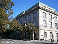 Jersey City Main Library


References
- ^ "National Register Information System". National Register of Historic Places. National Park Service. March 13, 2009.
- ^ "New Jersey and National Registers of Historic Places - Hudson County" (PDF). New Jersey Department of Environmental Protection - Historic Preservation Office. July 7, 2009. p. 7. Retrieved August 3, 2010.
- ^ * Van Vorst Park Historical District
- ^ Snyder, John P. The Story of New Jersey's Civil Boundaries: 1606-1968, Bureau of Geology and Topography; Trenton, New Jersey; 1969. p. 148. Accessed June 26, 2013.
- ^ "Library Guides: Van Vorst Park: Van Vorst Park".
- ^ "Library Guides: Van Vorst Homestead Site: Van Vorst Homestead Site".
- ^ Hamilton Park Neighborhood and Historic District
- ^ JERSEY CITY POWERHOUSE TO UNDERGO FIRST PHASE OF LONG-AWAITED RESTORATION
- ^ The Pennsylvania Railroad Harsimus Branch Embankment, Jersey City, NJ Archived 2009-05-23 at the Wayback Machine
- ^ "Jersey City, Past and Present".
External links
- Neighborhood Association Website
- Van Vorst Park Map
- Grove Street Shoppers Guide and Neighborhood Map
- Walking tour of Van Vorst
- Friends of Van Vorst Park
- Not Yo Mama's Craft Fair
- Van Vorst Park (2005 Film)
- Jersey City Main Library
40°43′06″N 74°02′46″W / 40.7183°N 74.0462°W
| Bergen-Lafayette |  | |
|---|---|---|
| Downtown | ||
| Greenville | ||
| The Heights | ||
| Journal Square | ||
| Meadowlands | ||
| Upper New York Bay | ||
| West Side | ||
| Historical | ||
| Topics | |
|---|---|
| Lists by state |
|
| Lists by insular areas | |
| Lists by associated state | |
| Other areas | |
| Related | |
- Neighborhoods in Jersey City, New Jersey
- Historic districts in Hudson County, New Jersey
- Houses on the National Register of Historic Places in New Jersey
- National Register of Historic Places in Hudson County, New Jersey
- Parks in Hudson County, New Jersey
- Houses in Hudson County, New Jersey
- New Jersey Register of Historic Places
- Squares in Jersey City, New Jersey
- Parks on the National Register of Historic Places in New Jersey