Valsøyfjord Municipality
Valsøyfjord herred | |
|---|---|
| Valsøfjorden herred (historic name) | |
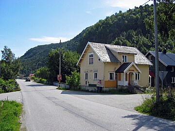
 View of the municipality | |
 Møre og Romsdal within Norway | |
 Valsøyfjord within Møre og Romsdal | |
| Coordinates: 63°08′16″N 08°29′27″E / 63.13778°N 8.49083°E | |
| Country | Norway |
| County | Møre og Romsdal |
| District | Nordmøre |
| Established | 1 Jan 1894 |
| • Preceded by | Aure Municipality |
| Disestablished | 1 Jan 1965 |
| • Succeeded by | Halsa and Aure |
| Administrative centre | Engan |
| Area (upon dissolution) | |
| • Total | 156 km2 (60 sq mi) |
| Population (1965) | |
| • Total | 1,245 |
| • Density | 8.0/km2 (21/sq mi) |
| Demonym | Valsøyfjording [1] |
| Time zone | UTC+01:00 ( CET) |
| • Summer ( DST) | UTC+02:00 ( CEST) |
| ISO 3166 code | NO-1570 [2] |
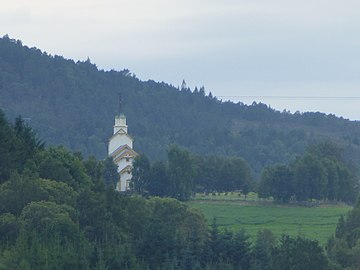
Valsøyfjord is a former municipality that was located in Møre og Romsdal county, Norway. The 156-square-kilometre (60 sq mi) municipality existed from 1894 until 1965. The municipality included the land surrounding the Valsøyfjorden and its entrance at the Arasvikfjorden in the present-day municipalities of Aure (in Møre og Romsdal county) and Heim (now in Trøndelag county). It included a small part of island of Ertvågøya and the whole island of Valsøya as well on the mainland. The main church for the municipality, Valsøyfjord Church was located in the village of Valsøyfjord. The administrative centre was the village of Engan. Other villages in the municipality included Arasvika, Valsøybotnen, and Hjellnes. [3]
History
The municipality of Valsøyfjord was established on 1 January 1894 when the larger Aure Municipality was divided into two municipalities: Aure (population: 3,245) in the north and Valsøyfjord (population: 942) in the south. During the 1960s, there were many municipal mergers across Norway due to the work of the Schei Committee. On 1 January 1965, Valsøyfjord municipality was abolished and its land was divided between two neighboring municipalities. The parts of Valsøyfjord on the island of Ertvågøya (population: 141) was merged with Aure Municipality and the rest of Valsøyfjord (population: 1,104) was merged with Halsa Municipality. [4]
Name
The municipality (originally the parish) is named after the local Valsøyfjorden ( Old Norse: Vallangr). The fjord is named after the island of Valsøya ( Old Norse: Vallangsøy) which is located in the mouth of the fjord. The first element of both names comes from vǫllr which means " meadow" or "flat ground". The last element of the island's name is øy which means " island". The last element of the old fjord name is angr which means " fjord". Thus, Valsøyfjord means something like the "meadow island fjord". [5] Historically, the name of the municipality was spelled Valsøfjorden. On 3 November 1917, a royal resolution changed the spelling of the name of the municipality to Valsøyfjord, adding a "y" and removing the definite form ending -en. [6]
Government
While it existed, this municipality was responsible for primary education (through 10th grade), outpatient health services, senior citizen services, unemployment, social services, zoning, economic development, and municipal roads. During its existence, this municipality was governed by a municipal council of directly elected representatives. The mayor was indirectly elected by a vote of the municipal council. [7]
Municipal council
The municipal council (Herredsstyre) of Valsøyfjord was made up of 17 representatives that were elected to four year terms. The party breakdown of the final municipal council was as follows:
| Party name (in Norwegian) | Number of representatives | |
|---|---|---|
| Labour Party (Arbeiderpartiet) | 11 | |
| Conservative Party (Høyre) | 1 | |
| Christian Democratic Party (Kristelig Folkeparti) | 1 | |
| Centre Party (Senterpartiet) | 4 | |
| Total number of members: | 17 | |
| Party name (in Norwegian) | Number of representatives | |
|---|---|---|
| Labour Party (Arbeiderpartiet) | 10 | |
| Conservative Party (Høyre) | 1 | |
| Christian Democratic Party (Kristelig Folkeparti) | 1 | |
| Centre Party (Senterpartiet) | 4 | |
| Local List(s) (Lokale lister) | 1 | |
| Total number of members: | 17 | |
| Party name (in Norwegian) | Number of representatives | |
|---|---|---|
| Labour Party (Arbeiderpartiet) | 10 | |
| Christian Democratic Party (Kristelig Folkeparti) | 1 | |
| Farmers' Party (Bondepartiet) | 3 | |
| Local List(s) (Lokale lister) | 3 | |
| Total number of members: | 17 | |
| Party name (in Norwegian) | Number of representatives | |
|---|---|---|
| Labour Party (Arbeiderpartiet) | 9 | |
| Christian Democratic Party (Kristelig Folkeparti) | 2 | |
| Joint List(s) of Non-Socialist Parties (Borgerlige Felleslister) | 5 | |
| Total number of members: | 16 | |
| Party name (in Norwegian) | Number of representatives | |
|---|---|---|
| Labour Party (Arbeiderpartiet) | 10 | |
| Christian Democratic Party (Kristelig Folkeparti) | 1 | |
| Farmers' Party (Bondepartiet) | 4 | |
| Liberal Party (Venstre) | 1 | |
| Total number of members: | 16 | |
| Party name (in Norwegian) | Number of representatives | |
|---|---|---|
| Labour Party (Arbeiderpartiet) | 10 | |
| Christian Democratic Party (Kristelig Folkeparti) | 2 | |
| Joint List(s) of Non-Socialist Parties (Borgerlige Felleslister) | 4 | |
| Total number of members: | 16 | |
| Party name (in Norwegian) | Number of representatives | |
|---|---|---|
| Labour Party (Arbeiderpartiet) | 9 | |
| Farmers' Party (Bondepartiet) | 5 | |
| Liberal Party (Venstre) | 2 | |
| Total number of members: | 16 | |
| Note: Due to the German occupation of Norway during World War II, no elections were held for new municipal councils until after the war ended in 1945. | ||
Media gallery
-
 Old municipal government house in Engan
 -
 View of the Valsøyfjorden
 -

-
-
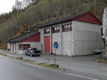 Valsøyfjord power station


See also
References
- ^ "Navn på steder og personer: Innbyggjarnamn" (in Norwegian). Språkrådet.
- ^ Bolstad, Erik; Thorsnæs, Geir, eds. (26 January 2023). "Kommunenummer". Store norske leksikon (in Norwegian). Kunnskapsforlaget.
- ^ Thorsnæs, Geir, ed. (12 November 2015). "Valsøyfjord". Store norske leksikon (in Norwegian). Kunnskapsforlaget. Retrieved 7 April 2019.
- ^ Jukvam, Dag (1999). Historisk oversikt over endringer i kommune- og fylkesinndelingen (PDF) (in Norwegian). Statistisk sentralbyrå. ISBN 9788253746845.
- ^ Rygh, Oluf (1908). Norske gaardnavne: Romsdals amt (in Norwegian) (13 ed.). Kristiania, Norge: W. C. Fabritius & sønners bogtrikkeri. p. 444.
- ^ "Norsk Lovtidende. 2den Afdeling. 1917. Samling af Love, Resolutioner m.m". Norsk Lovtidend (in Norwegian). Kristiania, Norge: Grøndahl og Søns Boktrykkeri: 1057–1065. 1917.
- ^ Hansen, Tore; Vabo, Signy Irene, eds. (20 September 2022). "kommunestyre". Store norske leksikon (in Norwegian). Kunnskapsforlaget. Retrieved 1 January 2023.
- ^ "Kommunevalgene 1963" (PDF) (in Norwegian). Oslo: Statistisk sentralbyrå. 1964. Retrieved 24 April 2020.
- ^ "Kommunevalgene og Ordførervalgene 1959" (PDF) (in Norwegian). Oslo: Statistisk sentralbyrå. 1960. Retrieved 24 April 2020.
- ^ "Kommunevalgene og Ordførervalgene 1955" (PDF) (in Norwegian). Oslo: Statistisk sentralbyrå. 1957. Retrieved 24 April 2020.
- ^ "Kommunevalgene og Ordførervalgene 1951" (PDF) (in Norwegian). Oslo: Statistisk sentralbyrå. 1952. Retrieved 24 April 2020.
- ^ "Kommunevalgene og Ordførervalgene 1947" (PDF) (in Norwegian). Oslo: Statistisk sentralbyrå. 1948. Retrieved 24 April 2020.
- ^ "Kommunevalgene og Ordførervalgene 1945" (PDF) (in Norwegian). Oslo: Statistisk sentralbyrå. 1947. Retrieved 24 April 2020.
- ^ "Kommunevalgene og Ordførervalgene 1937" (PDF) (in Norwegian). Oslo: Statistisk sentralbyrå. 1938. Retrieved 24 April 2020.
Møre og Romsdal county,
Norway | |||||||
|---|---|---|---|---|---|---|---|
| |||||||
 | Towns & cities |
| |||||
| Municipalities |
| ||||||
| |||||||