| This is an archive of past discussions. Do not edit the contents of this page. If you wish to start a new discussion or revive an old one, please do so on the current talk page. |
| Archive 1 | Archive 2 | Archive 3 |
Re:New Europe maps
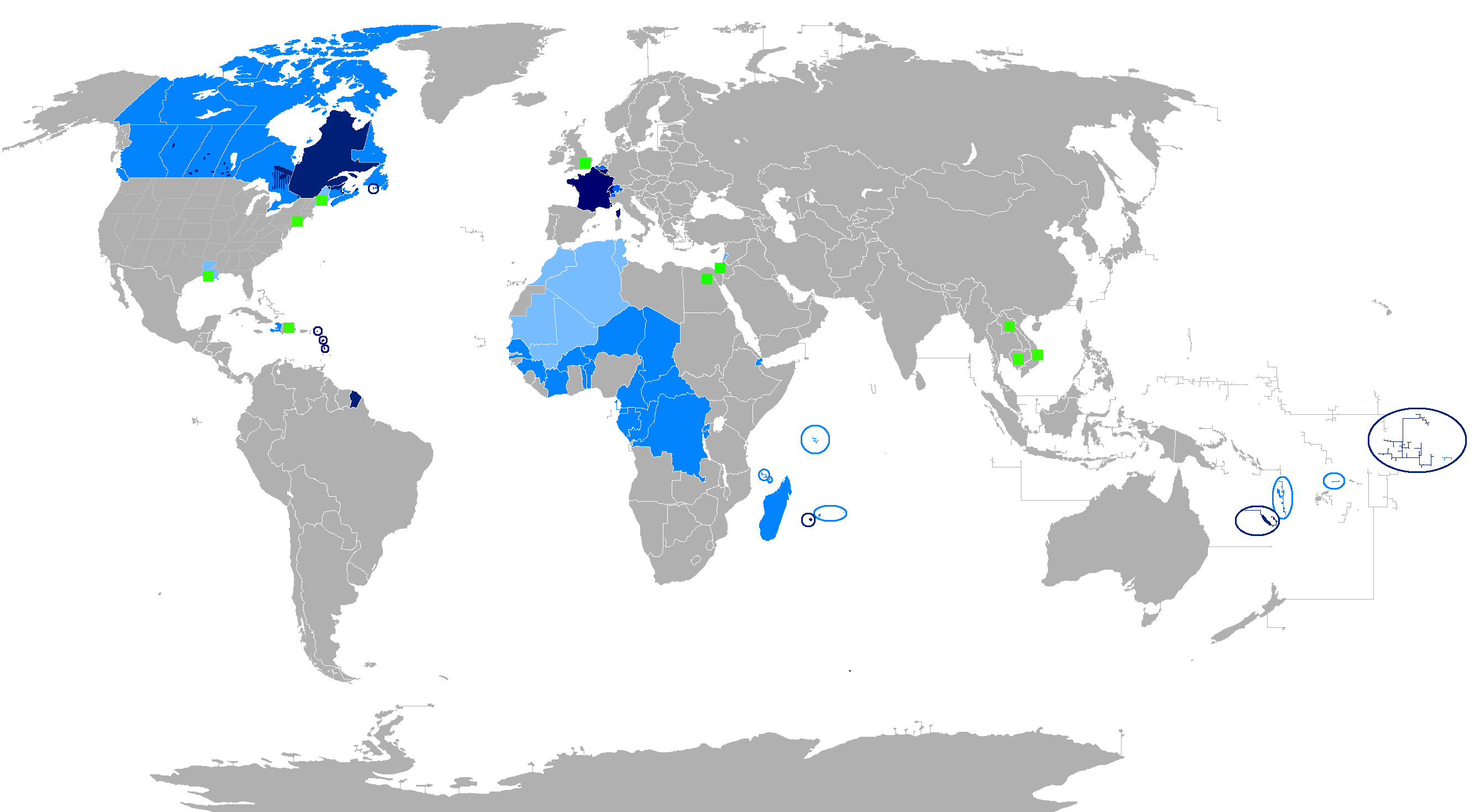
Do you like them? I'm sorry, but someone has removed them with no explanation and I had to revert them all manually. As for your question, the color scheme is based on the standards of WikiProject Maps. I decided not to use the solid red because it began to hurt my eyes, the red I chose I think is much easier for the viewers' eyes. — Nuclear Vacuum 03:32, 17 October 2009 (UTC)
- Yeah, they're good. As long as they are used for all European countries (for consistency), I'm fine with it. Perhaps it'd be better to label the 'red-orange' colour as simply 'red'; at first I thought both colours were used (red for the mainland and orange for territories or something similar), so it might be best to clarify this. If you could also update the maps for England, Scotland, Wales, and Northern Ireland, it'd be great. Best regards, Hayden120 ( talk) 03:37, 17 October 2009 (UTC)
- Well thank you so very much. I am glad that someone likes them. No need to worry, I have all the EU countries made up here, but I can only upload a few at a time, so it may be a few days for all of them to be up. If you wish to change the term to "red," than be my quest (I have nothing wrong with that). As for making maps of England and so on, I think I can do that at some point. Now I am tempted to start =D I also would like to ask you a favor, can you compare the coloring of File:EU-Spain.svg and File:EU-France.svg, and which one of these reds do you think is better? — Nuclear Vacuum 03:46, 17 October 2009 (UTC)
- Hmm, I quite like the red in the France one, it looks more definite and stands out more to the reader. Also, would you be able to add a world map in the corner? It aids those who are not familiar with world geography. Here is one example of an EU country, and a non-EU country. Hayden120 ( talk) 04:02, 17 October 2009 (UTC)
- There is a minor issue with File:EU-United Kingdom.svg; the Isle of Man and the Channel Islands should not be shaded red, they are not part of the UK. Also, is there any reason why there are bodies of water with blue borders around them? I'm not quite sure if this is necessary. Hayden120 ( talk) 06:24, 17 October 2009 (UTC)
- Well, I took your advice and made all the maps red. I also wanted to tell you that I am now done with them all. May I ask you for a favor, can you comment here on your thoughts as well. As for the bodies of water, I thought that those were the proper coloring to use, but I'm not too sure. As for the areas belonging to the UK, that is a coding problem that I will fix right now. The map I used has those areas part of the UK, and I just filled them in by accident. Thank you again for your support. — Nuclear Vacuum 17:11, 17 October 2009 (UTC)
- Nice work. I think the bodies of water should still be blue, it was just the bright blue borders that looked out of place. Do you know how to include a world map in the corner? Bosonic dressing may be able to help you otherwise. Also missing is the border for the European continent. I'm a little bit concerned about the lack of standardisation now though, it took forever to get everyone to accept the green one—now we have a mix of the two. Are you currently working on the other European countries? Thanks, Hayden120 ( talk) 00:15, 18 October 2009 (UTC)
It'll be a while, but I think I can get those all up and running shorty. — Nuclear Vacuum 02:44, 18 October 2009 (UTC)
- Great news, I think I have a winner here. Please check out my updated map on the United Kingdom, it includes a separation between Europe and Asia/Africa, no blue borders on water, and includes a global location map at the top-left of the image. So far I have only done the UK in this new formatting, and it may take a while before I can have all 27 member states of the EU up in this format (not including all the other nations of Europe). But please tell me what you think of it. — Nuclear Vacuum 03:55, 18 October 2009 (UTC)
- I have created a category on the Commons which contains both EU and non-EU Europe maps (I'm currently making the latter). I've so far made three maps, but unfortunately I am having difficulties making more because some countries share borders. I can only colour in some of the border light-red because the rest is attached to another country. Do you know how to fix this? Hayden120 ( talk) 06:11, 18 October 2009 (UTC)
- Hmmm, I'm starting to wonder how valid the map conventions are. After having a look around at other country articles, I've noticed that all of them use the green and grey scheme. I think there needs to be a thorough discussion with other editors before changing all the maps. Hayden120 ( talk) 07:17, 18 October 2009 (UTC)
- I take it you sure like them. I think I know what the problem you are talking about it. You see, I combined all the nations of the EU together so making the EU maps would be easier to work with. I may have to go through them a little, but other than that, I am glad that you like them. — Nuclear Vacuum 16:25, 18 October 2009 (UTC)
- I had the maps orange originally, but it looked a bit odd (somewhat dark). I thought since the continent of Europe was a secondary colour in the non-EU maps (whereas on the EU maps, the EU is secondary and Europe is tertiary) that it'd be fine coloured light yellow. I'm still not sure about changing the colours from green and grey though; it has become the de facto standard across Wikipedia's country articles. Also, and I'm not sure if you can be bothered now, would you be able to colour the country inside the world map? Hayden120 ( talk) 20:44, 18 October 2009 (UTC)

OK, I made a "green and grey" version. What do you think? — Nuclear Vacuum 01:30, 19 October 2009 (UTC)
- Yeah that looks great, and much more suitable as it fits with the rest of Wikipedia. Sorry to be a pest (:P). Hayden120 ( talk) 02:07, 19 October 2009 (UTC)
Brazil
Hello! Please, I need your help to deal with an issue that has appeared in the article about Brazil. See it in here. Thank you very much. - -- Lecen ( talk) 19:09, 28 October 2009 (UTC)
- I will make a brief summary of the problem: I started to rewrite the section “History” in the article on Brazil. The idea was to improve the text changing the old citations based on websites for books written by several renowned historians. I had already rewritten three subsections without having received complains from other users. In the fourth subsection that deals with the reign of Emperor Pedro II, I received serious complains from user Opinoso who made baseless personal accusations against me for no reason. I sent him a private message asking him to get into a peaceful resolution to the matter, but he simply ignored me and kept with the accusations, attacks and ironic remarks towards me. After that he added untrue information in the subsection. And even more serious: he was not faithful to his own sources and created information that did not exist in the sources, as I managed to prove in the discussion page.
Test your World War I knowledge with the Henry Allingham International Contest!

As a member of the Military history WikiProject or World War I task force, you may be interested in competing in the Henry Allingham International Contest! The contest aims to improve article quality and member participation within the World War I task force. It will also be a step in preparing for Operation Great War Centennial, the project's commemorative effort for the World War I centenary.
If you would like to participate, please sign up by 11 November 2009, 00:00, when the first round is scheduled to begin! You can sign up
here, read up on the rules
here, and discuss the contest
here!
This has been an automated delivery by
BrownBot (
talk) 18:59, 8 November 2009 (UTC)
The Military history WikiProject Newsletter : XLIV (October 2009)
The
October 2009 issue of the Military history WikiProject newsletter has been published. You may read the newsletter, change the format in which future issues will be delivered to you, or unsubscribe from this notification by following the link. Thank you.
This has been an automated delivery by
BrownBot (
talk) 18:59, 8 November 2009 (UTC)
Strange bot edit ...
It's not my bot, but I think this edit to the interwiki links on Francia is based on where the linked-to article on the other wikis are linked to. For example, de:Fränkisches Reich didn't link to en:Francia but to en:Carolingian Empire (I have since changed it), so the bot removed the back-link on Francia. Does that make sense? Angus McLellan (Talk) 15:36, 16 November 2009 (UTC)
North German Plain
I did not move the talk because both pages had relevant talk, and one would have to be deleted. Since each talk comment is signed, attribution is achieved, and you are allowed to do a cut and paste copy of the talk to the one with the capital P. Graeme Bartlett ( talk)
Map size
Hi Hayden. Fantastic job on the Template:Canada image map. Currently the article Canada is undergoing a Wikipedia:Featured article review#Canada. The map seems to be noticeably quite large when looking at its placement in the article. Is it at all possible to slightly reduce the size of the map to make it a better fit? Mkdw talk 09:49, 28 November 2009 (UTC)
- G'day, I've changed the size from 650px to 550px. Hopefully that's a bit better. I'm not sure whether to make it any smaller though, the text might be difficult to read. Thanks, Hayden120 ( talk) 07:53, 2 December 2009 (UTC)
- Actually, would you mind editing it again? There's been a concern raised at Canada's FARC that "The big map of Canada is good, except (1) it doesn't explain what "clickable" really means, and (2) the key at the bottom is illegible." Thanks, Nikkimaria ( talk) 14:08, 15 January 2010 (UTC)
Talkback

Message added 22:26, 23 January 2010 (UTC). You can remove this notice at any time by removing the {{Talkback}} or {{Tb}} template.
RWJP ( talk) 22:26, 23 January 2010 (UTC)
Barnstar
Thank-you very much for the Barnstar you awarded me, I'm very glad about recieving it. Your help was appreciated too! mgeo talk 15:58, 5 February 2010 (UTC)
Norway and HDI
The HDI only verifies that Norway is the most developed country in the world, not that Norway is the best country to live in.-- 90.149.222.38 ( talk) 12:24, 9 February 2010 (UTC)
- Generally the level of development equates to the quality of life. But okay, you have a point—this part probably could be removed. It is hard to take you seriously, however, when you start throwing terms like 'dictatorship' around. You may wish to read dictatorship. Hayden120 ( talk) 12:28, 9 February 2010 (UTC)
- There is no definition on dictatorship on that wiki-page, only a list of persons claimed to be dictators. —Preceding unsigned comment added by 90.149.222.38 ( talk) 12:55, 9 February 2010 (UTC)
- The very first paragraph lists the three possible meanings. Or, you could try Britannica [1], which states: "form of government in which one person or a small group possesses absolute power without effective constitutional limitations." This is not true for the current government of Norway. You could always try living in some of the poorer parts of Africa or Asia to see the true meaning of 'dictatorship'. I'm starting to suspect that I'm being trolled by this discussion. Regardless, this is all a waste of time, unless you can provide reliable sources. Hayden120 ( talk) 13:05, 9 February 2010 (UTC)
Zondor and his discuss template
FYI, I've asked Zondor to comment about his addition of these templates on his talk page. -- AussieLegend ( talk) 13:33, 10 February 2010 (UTC)
Swiss Army Logo
http://de.wikipedia.org/wiki/Datei:Vsa_logo.gif
need some Times .. for replication uinto the pzublic images server —Preceding unsigned comment added by Xyox ( talk • contribs) 12:54, 11 February 2010 (UTC)
- Hello, please note that images uploaded to the German Wikipedia cannot be shared with the English Wikipedia. Images need to be uploaded to Wikimedia Commons if you wish to use them on multiple projects. However, it appears you are uploading copyrighted images—which is not allowed on WikiCommons, nor on here if you do not have a fair-use rationale—and removing the free, existing ones. It would be appreciated by fellow editors if you could also use the edit summary to explain the changes you are making. Thanks, Hayden120 ( talk) 13:08, 11 February 2010 (UTC)
Sako TRG image
I provided a non-free use rationale for using the FDF 8.6 TKIV 2000 image. I could not find a free picture of a thus kitted out 8.6 TKIV 2000 rifle system. That is no surprise, since a custom made Zeiss telescopic sight is part of this particular sniper weapon system. Non-free use rationale can probably not be used on Wiki Commons, so I did not re-upload the image there.-- Francis Flinch ( talk) 15:49, 11 February 2010 (UTC)
- Yep, I noticed you just changed the licencing. Only images that are completely free (including for commercial purposes) are allowed on Wikimedia Commons, so it was wise to upload it here. I've always had trouble maintaining non-free media, though. Hayden120 ( talk) 15:57, 11 February 2010 (UTC)
Iceland, Republic of
If you haven't seen the recent changes to the Iceland page, specifically the name, you might want to take a look. There's an editor who's trying to undo the consensus you guys made about the "republic of" issue. I think he's a little obsessive about some he calls "long-form names", as I found from his talk page. It seems a bit bizarre to me. He's had himself banned over it, I think. You might want to take a look at the conversation I've been having with him as well. It's in 2 parts. Thank you for your time. -- Leodmacleod ( talk) 20:24, 16 March 2010 (UTC)
- Hello, yep, I saw the changes being made to Iceland and reverted it once. It's quite frustrating when you think we've reached a consensus, and then another editor comes along and starts it all over again. I thought the letter from the Office of the PM would make it clear ('republic' is only used descriptively), so I'm not sure what else to add to the discussion. I'm hoping some other editors can also chime in. Hayden120 ( talk) 02:00, 17 March 2010 (UTC)
Mannanafnanefnd and DYK
Hello. I just added some minor stuff to Mannanafnanefnd, nice stub. Something you may find useful: next time you plan on an article that features some interesting fact or has an unusual angle, you may want to propose it to DYK ( Wikipedia:Did you know) for feature on the Main Page. I mean, I'm pretty sure a summary such as Did You Know "...that Mannanafnanefnd is the committee that regulates names in Iceland?" would have made it to the Main Page. (DYK is a nice thing, but it's heavily about Anglo topics, so stuff from Iceland or elsewhere would surely be nice.)
WP:DYK has a laundry list of rules for an article to be eligible, but I think the two main ones to know beforehand are: (1) 1500 characters of prose text (not counting lists, references, links) and (2) being created less than 6 days ago. Obviously it's too little and too late for Mannanafnanefnd, but another time you could develop the article in user space for as long as you want and then post it once you have it long enough for immediate proposal to DYK. Of course it's completely optional, but being featured at DYK can bring readers, corrections, additions, etc. Cheers. 62.147.25.32 ( talk) 01:38, 17 March 2010 (UTC) (P.S.: I've also added it the other day to Wikipedia:Unusual articles, which is a complement or an alternative to DYK. 62.147.25.32 ( talk) 01:48, 17 March 2010 (UTC))
- G'day, thanks. Yeah, I was thinking of nominating it for a DYK, but after having a look at some of the other DYKs for that day, I didn't think it was long or substantial enough to fit the criteria. Thanks for your improvements to the article! Hayden120 ( talk) 02:00, 17 March 2010 (UTC)
Map of Svalbard
Hi! I'm doing a cleanup of Svalbard, and saw the nice File:Europe-Norway.svg you made. I've tried to create a similar map just showing Svalbard (since the .svg maps are a lot better looking than the current .png), but I don't seem to be able to ungroup Svalbard to color only it, and not the rest of Norway (I am only a n00b when it comes to Inkscape). Since you seem to have a grip on this stuff, it would be very appreciated if you could help me out here. Arsenikk (talk) 12:48, 28 March 2010 (UTC)
- G'day, I'm quite a 'n00b' with Inkscape too, to be honest. I can't take credit for the original map, sorry; User:NuclearVacuum started replacing the EU maps with .svg format, and I made a few extra non-EU ones by simply altering the colours. We went through a few different styles before we finally agreed on the green and grey format. I had troubles with grouping too, but NuclearVacuum was able to sort them out... not sure how, though. It'd be best to leave him a message... I'm sorry for not being much help. Best regards, Hayden120 ( talk) 14:01, 29 March 2010 (UTC)
- Edit: I have left a message on his talk page. Thanks, Hayden120 ( talk) 14:15, 29 March 2010 (UTC)
- I just want all of you to know that I am now the Tsar of SVGland! Lolz, no seriously, I am amazed that you came to me for this, I am honored. Well, taking a look at the map, the reason you can't click and separate Norway from Svalbard (or SVGlbard ;3) is because both are part of a single path. Currently, I have no idea how to make such a detailed connection like how it is done on this map here. However, I happen to be an expert on separating them for you. Follow these steps and you should do it quite well.
- Select Norway on the map.
- Copy Norway.
- Go to Edit and click on the selection which reads "Paste in Place." This will make two Norways on top of each other.
- Click the "Edit paths by Node" tool (click F2 on the keyboard). This will make little nodes appear on the borders of Norway.
- Select all of the node of Norway (leaving Svalbard's node alone).
- Delete these nods by selecting the "Delete selected nodes" icon on the top-left corner of the screen.
Icesave referendum
Hello again. Another request for move has started and I'm hoping that this time around we'll finally be able to close the book on this one. If you could leand us your suppor then that would be great.-- Icelandic Viking POWER ( talk) 23:25, 23 April 2010 (UTC)
reflinks lowercases initial letter unnecessarily
Re Danelaw: the Reflinks template changes the initial letter of a piped link unnecessarily. While this is does not break the link, it seems more appropriate to pipe the link to the actual article title. Your edit using the template changed, for example, [[Baptism|baptised]] to [[baptism|baptised]]; as the title of the article linked is "Baptism", this is arguably inappropriate. The author of the Reflinks template disagrees and supports the case change (I have discussed this with him on his Talk page). Pol098 ( talk) 13:33, 24 April 2010 (UTC)
- It doesn't matter if the link is lower case or upper case, it will still link directly to the article. Wikimarkup isn't affected by the case of the first letter. If the word in the article is lower case, e.g. the verb 'baptised', then it doesn't matter if the link is also lower case. Besides, this seems rather trivial; feel free to change it back if it bothers you. The main function of Reflinks is to format and fill-in citations; the case is just a minor fix and doesn't really matter. Hayden120 ( talk) 14:19, 24 April 2010 (UTC)
- Agreed, but changing [[Baptism|baptised]] to [[baptism|baptised]] seems perverse and unnecessary. It wasn't broke; don't "fix" it without good reason. In previous discussions others have agreed with this viewpoint. The case is not "just a minor fix", it's not a "fix" at all, just unnecessary and unwanted meddling, though indeed minor and not changing behaviour. This has been discussed and others have also disapproved of changing the case of the first letter: User talk:Dispenser#Incorrect capitalisation in piped references Pol098 ( talk) 14:39, 24 April 2010 (UTC)
- I'm sorry, obviously I'm not the creator of the program, so I have no control over this issue. Yes, you're right about it not being a fix, it doesn't correct anything. Poor choice of words by me, there. However, I find Reflinks incredibly useful for its main purpose, and don't really care about a few tweaks that don't affect the article in any detrimental way. I can't really be bothered picking through and reverting all these tweaks after running it, so you might want to continue discussing this with the creator. Best regards, Hayden120 ( talk) 14:50, 24 April 2010 (UTC)
Europe
Dear Hayden120, I am restoring the previous version and in case you still stand on deleting credited and referred info i provided, please, explain yourself. thnx. —Preceding unsigned comment added by Nickniko ( talk • contribs) 10:16, 19 May 2010 (UTC)
- Firstly, you are not even explaining what you are doing in your edit summaries. Secondly, you are removing references and replacing them with information that is tagged with ' citation needed' – you want people to add references to your inclusions? This does not help Wikipedia. Hayden120 ( talk) 10:55, 19 May 2010 (UTC)
Thanks
Thanks for your reply! I agree fully with you - I understand that the current format may be neat, but with population figures it might get a bit confusing as they change. Especially as the source used for some cities (Lugano and Lausanne) doesn't contain any data. Cheers! Jeppiz ( talk) 15:54, 27 May 2010 (UTC)
Stockholm
I've posted a note on Zaxxor's talk page requesting that he discuss his editing on the talk page. Please feel free to initiate the discussion if you wish. Mjroots ( talk) 17:57, 5 June 2010 (UTC)
- Thanks. I think I'll wait until Zaxxor replies... his changes were numerous, unexplained and bizarre. He removed the montage in the infobox and replaced it with a rather unrepresentative picture, and removed the panorama and climate chart. He also replaced (and removed some, with no replacement) about 12 of the article's other pictures. I'm going to assume good faith, but the edits were... curious. Hayden120 ( talk) 03:36, 6 June 2010 (UTC)
Iceland
Oh, thanks for that! I did not know we had that template. I can see how it could be quite handy. On a side note; using all caps makes it seem like you are angry with me, I assure you I was only doing what I thought was best for the encyclopedia. Now I know a better way to handle those situations and I appreciate you giving me the information. Cheers, Colincbn ( talk) 04:46, 17 June 2010 (UTC)
- No worries, and sorry about that. I didn't mean to come across as angry. It was just the important point of my edit summary; I thought I'd capitalise it to emphasise the importance. And of course, I knew the edit was done in good faith :). I just thought I'd let you know for future reference. Best regards, Hayden120 ( talk) 05:10, 17 June 2010 (UTC)
Old Norse topics
I am indeed interested in the template! This covers nicely what I'd hoped for in suggesting Category:Old Norse, but without being mostly duplicate content from Category:North Germanic languages. ᛭ LokiClock ( talk) 05:38, 17 June 2010 (UTC)
- Excellent :). But yeah, if you have any ideas, please feel free to change it. It appears some of the Swedish-related markup sneaked in from my previous template, but a lone IP editor was quick to fix it ;). Best regards, Hayden120 ( talk) 05:59, 17 June 2010 (UTC)
WPASK Invite
 | Hello, Hayden120/Archive 2! We are looking for editors to join WikiProject Anglo-Saxon Kingdoms, a collaborative effort which aims to create, expand, and maintain articles related to the Anglo-Saxon Kingdoms of England. Thanks! |
I saw you were working on Old English Topics, that would fit very well within our activities to expand articles related to the Anglo-Saxon Kingdoms. Hope to see you there. Sadads ( talk) 14:48, 18 June 2010 (UTC)
- G'day. Many thanks for the invite, but I don't tend to join many WikiProjects. My editing is very general, and therefore I have joined WikiProject Europe to broadly cover everything. If I were to join the WikiProject for every article I am involved with, there would be too many to manage.
- However, I do watch WikiProjects (including this one) and participate in some discussions. My knowledge of Anglo-Saxons is a bit limited (more focused on language, I suppose), so I don't particularly want to put my name on a list that might be sought for knowledge that I do not have. However, I will still help out where I can! Thanks again for the invite, Hayden120 ( talk) 15:45, 18 June 2010 (UTC)
Kalmar map
I've posted a response on my talk page. - SSJ t 00:34, 24 June 2010 (UTC)
temporary solution
About the Nordic countries population reference removal, I knew it was going to be fixed as my edit note mentioned and had no interest in making the full modification. Should have made the modification only for a preview (not submitting) and made a note in the discussion where it would have take 10 times to be fixed than by what I did? This is a legitimate concern. DynV ( talk) 08:03, 2 July 2010 (UTC)
- Hello. Yes, creating a discussion would have been exactly the right thing to do. I noticed this minor problem too, but didn't think it was significant enough to do anything about it. However, if you brought it up on the talk page, I would have fixed it. Please don't remove references from articles... it was lucky that I was there to fix it; your edit could have gone unseen and those references could have been forgotten. In future, please just use the talk page. Best regards,
Hayden120 (
talk) 14:18, 2 July 2010 (UTC)
- ``your edit could have gone unseen and those references could have been forgotten.`` I didn't think about that, it would have been a valuable loss. Sorry DynV ( talk) 01:08, 3 July 2010 (UTC) Oh I had an idea how to preserve the work of the reference removal while not submitting it: copy the content which goes through preview on pastebin which could be used by the editor that would pick up on the talk page. DynV ( talk) 02:44, 3 July 2010 (UTC)
AH-1Z
Awhile ago you asked about the probe on the front of the zulu it is a air speed probe that uses pitot, static, wind velocity and direction. —Preceding unsigned comment added by 70.181.142.108 ( talk) 06:07, 9 August 2010 (UTC)
Help
Hello. I do not speak English and I speak to you with googel translator. I am inter-braces in the project and wonder what it is like. how do I use the project? When I make a change to the pages, how do I do?. I like these projects, and how do I use the account so I can be anonoym.
Much obliged. —Preceding unsigned comment added by 83.109.207.160 ( talk) 12:09, 10 August 2010 (UTC)
- Hej. Vad är ditt modersmål? Norska? Kanske är Wikipedia på norska mer passande.
Här är en länk till hjälpsidan. Tack,
 Hayden120 (
talk) 12:23, 10 August 2010 (UTC)
Hayden120 (
talk) 12:23, 10 August 2010 (UTC)
- Not understanding of word. I not in speaking Norwegian. —Preceding unsigned comment added by 83.109.207.160 ( talk) 12:27, 10 August 2010 (UTC)
- In wikipedia of english, persona is many. 83.109.207.160 ( talk) 12:35, 10 August 2010 (UTC)
- *Confused*. I can see on your talk page that you are Polish. It might be best to contact a Polish Wikipedian for help. Best regards, Hayden120 ( talk) 12:43, 10 August 2010 (UTC)
Europe map

Hi there,
Would you be so kind to describe what errors you think the map contains, so that I can try to address them? I much prefer it to that other linguistic map, for many reasons. Regarding Swedish in Finland, it is my understanding that it is spoken in the coastal areas, which the map shows. Regards, Athenean ( talk) 21:59, 13 August 2010 (UTC)
- G'day, Athenean. There is a rather large list of errors on the image's talk page, here. Have you looked at Finland Swedish? Swedish is spoken in the south too. The most accurate map I know of is File:Languages of Europe.svg, but unfortunately there appears to be a glitch preventing it from displaying as a thumbnail. If you know how to fix this, that would be great. Cheers, Hayden120 ( talk) 22:31, 13 August 2010 (UTC)
- I see your point, however, it is impossible to have a map that pleases everyone. If I add Sloravian-speakers in western Izmetistan to please the Sloravian editors, the Izmetistani editors will pop a collective blood vessel. If I add Izmetistani-speakers in eastern Sloravia, the Sloravian editors will raise hell. I looked at the map you mentioned, and I could easily come up with just as many flaws. When I have time in the future, I will try to address some of the simplified map's most serious issues, like the Swedish speakers in southern Finland you mentioned, however, we need to draw the line somewhere. It simply is not possible to include every single language with a few hundred speakers, e.g. Satterland Frisian will have to wait. While the simplified map does have some easily fixed flaws, it can be fixed, and as long as we use the disclaimer that it is a simplified map, I don't see why it would be such a problem. Even in its current version it is far preferrable to the dreadful tricolor linguistic map currently used, wouldn't you agree? Athenean ( talk) 08:00, 14 August 2010 (UTC)
- Indeed, you can't please everyone. I actually added the very same map myself and excused it as "simplified" too, but then I noticed the rather large omission of the Swedish-speaking Finns (considering there are around 280,000 of them, leaving out the entire southern portion of them is a significant error) and decided to remove it. Admittedly, yes, Saterland Frisian is not *hugely* important, but it is a distinct minority, and its inclusion would not be controversial. At the very least, I would like to see Swedish in southern Finland corrected as soon as possible. Also, I agree; the tricolour map isn't particularly useful ("extremely simplified" comes to mind). Hayden120 ( talk) 08:15, 14 August 2010 (UTC)
Sweden Democrats
I am totally agree with your last modifications about Sweden Democrats. As you were cancelling the recent and partial adds made by Anarchovegan (Neither the Guardian nor Al Jazeera state that the party is fascist in these references. Stop inserting libellous vandalism into the article, Please see my last edit summary), I was doing exactly the same thing so that there was a conflict of modifications. So I restored involuntaraly the precedent litigious version that you removed 30 or 40 seconds ago. I feel sincerely sorry for that. For some days, some people try to insert libellous informations. The most important is to avoid polemic sources or partial informations, keeping a neutral point of view and using reliable sources. Comment added by Jeromemoreno ( talk • 15:37 in western France on 19 September 2010
- Yup, I thought it might have been an edit conflict. There is no need to apologise! I think that once a few weeks have passed after the election, all of this will die down. There have been quite a few people out there wishing to defame the SD before the election, but that is irrelevant now. Hopefully when the article is unlocked, it will stay stable. It needs to be kept neutral and free from sensationalist libel. Hayden120 ( talk) 03:07, 20 September 2010 (UTC)
Alright, I've unprotected this per request at WP:RFUP (see here as well); just watch your edits :). That's what the talk page is for! I'm sending this to the three other users who seem to have been involved as well. Best, Airplaneman ✈ 23:15, 20 September 2010 (UTC)
- View from France, I think that this poll is very interesting about SD and the other seven parties organized in two coalitions. SD has seemed to increase progressively for the recent general elections on 19 September 2010 (5.70%). According to Sifo/Svenska Dagblabet poll published on October 2010, SD attained 6.4%. SD attained actually 6.9%, one of its highest results in a poll. Before publishing, I saw the graphics and I think that this common work is very serious and reliable since 1.889 persons were questionned. In France, 800 or 900 persons (seldom ≥ 1,000) are questioned for a poll. In France, the polls are sometimes reliable for a global approach but not for a detailed analysis. I think that in Sweden the polls are very reliable. A DN/Synovate poll published on 10 September 2010 had forecast that SD would attain 6% and gain 21 parliamentary seats. Nine days later, SD polled 5.70% and secured 20 parliamentary seats. So, the poll was very close to the reality.
- When I discovered that my recent edit had been removed, I was a little disappointed. Since I don't want to act as the owner of this article, I didn't restore my last edit. That's why I want to thank you to have restored it with a short summary. Two months after the 2010 Swedish general election (covered a lot by TV and radio in France), I see concretely that there is still some passion about SD.
- By the way, I work also on an another article : Marine Le Pen. She can globally be compared to Siv Jensen. If you are interested and have enough time, would you like helping to expand this article with available and reliable sources in english or another language? If Marine Le Pen is chosen as the next FN president during the FN Congress at Tours, I think that many european media will talk and write about this event. If she is elected to lead the FN, she will run to the 2012 French presidential election. Even if polls are considered with cautiousness, she already polls 13%-14%. Jérôme MORENO HERRERO 15:00, 14 November 2010 (UTC) ( talk--Jérôme MORENO HERRERO 15:07, 14 November 2010 (UTC)
Good catch
I didn't notice the inaccuracy of this map; Rome only held much of Germania from 5-9 AD. I think no one reverted it because no one noticed! I'll nom the image for deletion. Swarm X 15:26, 1 December 2010 (UTC)
.svg)
time to sort out the icesave / debt repayment / loan agreement dispute finally
hey there, this is just a bulk message inviting you to re-think the topic as was discussed more than 6 months ago and is still unresolved. feel free to jump here: http://en.wikipedia.org/wiki/Talk:Icelandic_debt_repayment_referendum,_2010#Time_to_settle_the_title_dispute.3F and help figure out how we can end this conclusively this time. -- Lotsofmagnets ( talk) 02:53, 5 January 2011 (UTC)
Your message about Eurofighter Typhoon
Please note that the IP-address you were referring to is a dynamic pool address for DSL dial-in (as you can easily verify using Whois), assignable to a lot of different users. E.g. I have never edited any article about eurofighters. — Preceding unsigned comment added by 87.78.48.49 ( talk) 23:18, 20 September 2011 (UTC) 87.78.48.49 ( talk) 23:24, 20 September 2011 (UTC)
English in Quebec (your reversion of the "Anglospeak" map)
So, would you be so kind as to recolor all of Canada into dark blue on the French language map, by the same rules you one-sidedly colored all of it as English speaking??! Greetings to the hopless unilinguals... 87.182.248.85 ( talk) 14:56, 10 December 2011 (UTC)
- Sigh. Regardless of Quebecois nationalist fantasies, the province is still just that. It is not a nation-state, and the Anglospeak map represents the majority for nation-states. Regional maps are problematic. For example, Inuit languages are spoken in northern Canada. Therefore, the top of Quebec isn't French-speaking. So, are we going to shade that? If you want it to be regional, Canada should look more like this (for English and French): File:Bilinguisme_au_Canada-fr.svg. There are regions in the US with Spanish-speaking majorities, regions in central and northern Australia with Aboriginal-speaking majorities, and the western fringes of Ireland and Scotland even have Gaelic-speaking majorities in some areas. The point is, simply shading Quebec invalidates the whole map. Hayden120 ( talk) 16:41, 10 December 2011 (UTC)
- SIGH. I'm not from Quebec nor a francophone native speaker, and I only fantasize about things that aren't appropriate stating here since probably rated R... But: Do you have the capacities to simply answer my question? I quote it really easy for you: "So, would you be so kind as to recolor all of Canada into dark blue on the French language map, by the same rules you one-sidedly colored all of it as English speaking??!" That's [ that] one. 87.182.248.85 ( talk) 16:58, 10 December 2011 (UTC)
- Well, that says it all. Neutral information is not what some anlophones seek here... Tschüss du Depp 87.182.248.85 ( talk) 17:37, 10 December 2011 (UTC)
- No, I can't be bothered for two reasons. Firstly, the way you approached me and implied that I'm a hopeless unilingual Anglo-Saxon. I consider that rude and uninformed. Secondly, why should I? I edit what I am interested in. French is not spoken in northern Quebec, so that map is obviously wrong, but I don't have the time nor the motivation to draw one up. If someone is concerned and motivated, there is nothing stopping them from modifying the map. Auf Wiedersehen! Hayden120 ( talk) 03:32, 11 December 2011 (UTC)
- Your "newsflash" in the file description was at least as "rude" as my approach. The maps are about official status, anyone able to read and write sees that in a jiffy. So, it is not a question of what is spoken in which Canadian village North, East, South or West but simply the federal status of French and English combined. And, a sad fact (besides the overwhelming unilingualism which doesn't really help to widen one's scope) is that anglophones always tend to put the English map in the same dark blue for both linguistic regions whereas they cry out like babies when someone asks to do so - by the very same justification - on the French map. Thus, if Quebec is not shaded or differentiated in some way on the English map (the better since correcter solution), the French map should include a fully colored dark blue Canada as well. Get that now? 87.182.252.188 ( talk) 12:35, 11 December 2011 (UTC)
- Sorry, having to deal with the same thing countless times gets tiring after a while. It wasn't directed at anyone in particular, nor personal. All I see here is a hostile Anglophobe (yes, we're all unilingual idiots...), and I'd appreciate it if you weren't so condescending. "Anyone able to read and write sees that in a jiffy"... You're really going there? Let's take a look at the description of the Anglospeak image. "[Dark blue] Countries where English is the national language or the native language of the majority. [Light blue] Countries where English is an official language, but not the majority language." Get that now? Hayden120 ( talk) 13:25, 11 December 2011 (UTC)
Scots Map

Excellent map, great work. Would it be possible to provide sources for the information contained. Unfortunately the north of Ireland is not included. Nogger ( talk) 11:14, 17 December 2011 (UTC)
- G'day, thank you
! The three sources (one for each date) are listed in the image description. The map is more to show the organic growth in Scotland stemming from Old English in the southeast. Perhaps if you could find a source showing the extent of Middle Scots and its growth in Ireland (then compared to now), then I could make another map with Northern Ireland included. Ireland might be more difficult to show in conjunction with the growth in Scotland, since Scots was artificially transplanted with the Plantation of Ulster.
Hayden120 (
talk) 14:50, 17 December 2011 (UTC)
- According to the article Scots language, Scots-speakers moved to Ulster from 1610 to the 1690s. Your map shows the extent of Early Scots by the beginning of the 15th century so the dialects in Ulster could be included in the shaded area for the present-day extent of Modern Scots. Nogger ( talk) 18:58, 7 January 2012 (UTC)
- True, but I just wish I had a source for Middle Scots to show some growth in Ulster too. Oh well, I have created a new map based on that suggestion: File:History of Scots in Scotland and Ulster.png. What do you think? Best regards, Hayden120 ( talk) 05:26, 8 January 2012 (UTC)
Belated reaction
Thanks for your reaction on the "religion in europe" page on my edit. I am not that often active , so bit late this response. Grsd ( talk) 21:42, 9 January 2012 (UTC)
- No worries
. My apologies for not checking before my initial revert.
Hayden120 (
talk) 11:22, 10 January 2012 (UTC)
New Indo-European branches map

I like the map. Some issues though: the Balto-Slavic is a new category you created, not supported by your source. Similarly, the source only mentions Romance, but you have it as Italic. Both feel inconsistent with wiki's WP:NOR guidelines. Please explain, add non-synthetic alternate source, or consider correcting the image. Additionally, the source breaks out Indo-Iranian into Iranian and Indo-Aryan, but you have them merged. FWIW, Indo-Iranian is a broader term of scholarship, just like the term Indo-European is; the languages have different alphabet, some similar sounding words mean opposite things, and Iranian and Indo-Aryan languages are as different as celtic and spanish (romance). It would be more accurate to color Iranian and Indo-Aryan differently, as done by your source Britannica: http://media-2.web.britannica.com/eb-media//83/1983-050-705E524C.gif Thanks, ApostleVonColorado ( talk) 13:54, 17 January 2012 (UTC)
- Many thanks. The map is essentially based on that source, as stated, but others too. "Balto-Slavic" is supported by sources here on Wikipedia, separated into two colours to support the alternative view that they are distinct. Romance is a level down in the family tree from Italic, and that is supported on Wikipedia with sources. Indo-Iranian is a level down from Indo-European, not a separate grouping. Different alphabet? Croatian and Russian don't use the same alphabet, so that is a false argument. Similar sounding words that mean opposite things? The English word sky was derived from an identical Norse word that meant "cloud" (a meaning carried through to its North Germanic descendants), so that is another false argument.
- Also, the breakdown of Indo-Iranian is contentious. It seems no one can agree on whether it consists of two, three or four groups (Iranian, Indo-Aryan plus Nuristani plus Dardic). Simply displaying them in their broadest classification would save the controversy. I'll add alternative sources. Hayden120 ( talk) 14:02, 17 January 2012 (UTC)
- Go ahead, add your sources into the image file. The currently cited source, Britannica, does not support the changes you introduced. I will check the image later for WP:OR, WP:SYNTH and WP:PSTS issues. Thanks, ApostleVonColorado ( talk) 14:22, 17 January 2012 (UTC)
- The added references (in legend) are good. However, now the figure is inconsistent with the new source: for example, Jonathan Slocum does not list parts of northwest France that are Celtic; they list Balkan as spoken in parts of Turkey; and, for that matter, Slocum does not support much of the finer details of distribution nicely shown or left blank in the new figure. So, I haven't been able to verify the currently colored regions in the new map from that source. Specifically, see, http://www.utexas.edu/cola/centers/lrc/general/IE.html; Wiki policies require us to present verifiable information, not truth (see WP:SOURCE; all that without synthesis ( WP:SYNTH). So, we must either use Britannica for color details, or find a source that supports your classification and color coding, or color code the new map according to the text of Slocum at University of Austin. By the way, I admire your effort and welcome it. Thanks, ApostleVonColorado ( talk) 15:25, 17 January 2012 (UTC)
- I now like it a lot more!! The caption is packed with information, more complete. Good work there. A few comments for your consideration: 1. Make the grey much lighter, so that the area you now have in light green stands out a lot more. 2. Split the color coding for Indo-Iranian just like your Britannica source; perhaps in lighter brown or pink; because it is difficult for the world audience to understand why the figure selectively uses info from Britannica, why does the figure combine one set and not the other. Moreover, coloring them together as one color prevents the kind of curiosity one feels when we see two shades of green. 3. You may want to include somewhere in the caption what light green is: just like the way Britannica does. You mention dots, but it is not obvious that dot means mixed green-grey (the dot could be interpreted as all grey area too). Cheers and have a wonderful day, ApostleVonColorado ( talk) 16:29, 17 January 2012 (UTC)
- Thank you! As for the comments:
- 1. Hmm, I think it'd be good to have the shade of grey in line with the majority of the rest of Wikipedia's globe maps (and, to be honest, it's very difficult for me to change the shade without messing up the entire map, especially with the transitional gradient from top to bottom, and the longitude/latitude lines which will blend in). Does the light green not show well on your monitor? I have viewed the image on four different devices and it has been clear.
- 2. I considered splitting Indo-Iranian but it raises two concerns – the fact that the map would be showing two descendants of a branch, rather than the branch itself, and also the contentious subgrouping of it (as noted in the caption). In any case, the Britannica map's legend actually links the two under one branch.
- 3. Light green is listed in the legend as "Balto-Slavic (Baltic)" to cater for both scholarly divisions (either as part of Balto-Slavic or alone as Baltic).
- 4(?). Dots approximately refer to multilingualism: for instance, red Germanic dots in a notably orange Celtic area show that both branches are used, and green Slavic dots and grey dots indicate that both Slavic and non-Indo-European language/s are used in the area (which non-Indo-European language/s is irrelevant for the purposes of this map).
- Also, a couple of notes just in case there is any confusion later: the source from UT university on the Celtic languages does indeed state "a group of Brythonic speakers left Britain following the Anglo-Saxon conquest and established new homes in Brittany (northwest France), where their Breton language, first attested in the 8th century, survives to this day." Also, it should be noted that the Celtic languages are spoken by a minority in most areas ( aside from northern Wales, essentially) but are marked with a full colour on the map (albeit with red Germanic or blue Italic/Romance dots). This is only an approximate representation, and primarily for visibility (which I suspect Britannica considered too). I hope this addresses your concerns, and I wish you a wonderful day too! Hayden120 ( talk) 16:49, 17 January 2012 (UTC)
- Just checked again. Here in the US, with three 2011 built 24+ inch monitors (HP, Apple versions) the dots do not show well. The Britannica source image is crystal clear - both is small scale and when blown up. This brought a few more details, not matching the source, which I submit to your attention. Sweden and Norway is more multilingual in the source document than what your figure shows. Same for Switzerland - you claim west Suisse is French, Britannica source claims it is multi-lingual (having lived in that area for quite a while, yes, French is primary language there but it indeed is multilingual). A few more spots have the same issue. On Indo-Iranian etc, yes source legend curls them into one, but draws them in different colors. A WP:NOR version would do the same: draw it in different colors like the source, and mention the fact that they are lumped together in the caption. If you decide to color it one, that is your decision, I mention my disagreement for the record and that you are doing something that the Britannica source doesn't. And for the record, once again, I like the effort you put into this. Cheers, ApostleVonColorado ( talk) 17:41, 17 January 2012 (UTC)
- Hmm, I'm not sure how to better represent the dots. The program I have been using only allows them to be one pixel in size. Besides, if they are any bigger it will give the impression of over-representation (particularly in the smaller areas). Upon enlarging the image, they are perfectly visible anyway. I actually think the Sami languages are somewhat over-represented in the Britannica image... but you are correct, I should display it the same way. It's an odd choice for Switzerland by Britannica. If they are going to mark western French-speaking Switzerland as multilingual, why isn't the German, Italian (oddly marked as Germanic) and Romansh portion multilingual too? I think it's best to simplify things a bit to gloss over these peculiarities (and please do not ask me to represent non-Indo-European areas in Russia precisely according to Britannica, because I will die of old age before I complete that). Also, and for the other spots (such as Romania), I have used other sources which are more regional and accurate to better represent them. For Indo-Iranian, I am also going by the article which states that it is one branch and can be broken into two, three or four subgroups, which the map doesn't represent. It's a bit of a juggling act to create a neutral map based on the text and the map. Many thanks, Hayden120 ( talk) 18:07, 17 January 2012 (UTC)
Europe language map
Hi there, I saw you replaced the European language map with a new one. Looks fairly accurate, so good job. One small request though: The map does not show the Greek language spoken in the southern parts of Albania. In the southern parts of Gjirokaster County and Vlore County, Greek is spoken by about 100,000-200,000 people, which I think is significant enough to warrant inclusion in the map. I do not have the technical expertise to do it myself, otherwise I would have made the modification myself. Thanks a lot, Athenean ( talk) 03:50, 21 February 2012 (UTC)
- I don't think we should hurry. Better check all the sources, because 100-200 is a pretty swollen figure. Greek is spoken in approximately 100 villages in Dropull, Albania, not exceeding 70-80 thousand. We have had some problems in Albania's general information (population: 95% Albanians, 3-6% Greeks, 2% others = that adds up to 100-103 percent [2].) Majuru ( talk) 20:50, 22 February 2012 (UTC)
- Hello Athenean! Andrei nacu created the map, so I can't take credit for it. It is indeed quite accurate! The SVG version doesn't display properly as a thumbnail, so I uploaded it as a PNG. I'm slightly dubious about the number of Greek speakers in Albania but if you can provide me with a source, I can attempt to modify the image. German is also not shown in Upper Silesia, so I'll try to fix that too. I'm not especially skilled with vector images, though. Hayden120 ( talk) 06:54, 2 March 2012 (UTC)