
2014-2015 Windstorm Season
August
Lena
Ex-Bertha
Ex-Cristobal
Iceland http://en.vedur.is/about-imo/news/nr/2975
September
Dutton's model storm which never happened. http://blogs.channel4.com/liam-dutton-on-weather/hurricaneforce-storm-september/7233 Dry
Autumn 2014 France and Italy Floods
| Date | ?? September 2014 – ?? November 2014 |
|---|---|
| Location | |
| Deaths | at least 11 [1] |
During Autumn 2014 repeated heavy rains brought severe flooding across areas of southern France and Northern Italy, as well as regions of Switzerland and Slovenia.
Hérault and Montpelier floods Genoa
17 Sept [3]
French flooding - http://www.bbc.co.uk/weather/feeds/29432593
storms also to eastern Spain and later to Italy. French gave rare red warning
"natural disaster" declared, 1 in 100 year event 29 September, No one is thought to have died in the floods, which come just 10 days after storms claimed the lives of four people in Lamalou-les-Bains and one in Aveyron. http://www.connexionfrance.com/Herault-flood-thunderstorm-Montpellier-16217-view-article.html
19 sept saharan dust http://www.eumetsat.int/website/home/Images/ImageLibrary/DAT_2343910.html http://www.meteofrance.fr/actualites?articleId=14227684
http://erccportal.jrc.ec.europa.eu/ERCMaps/ECDM_20140930_France_FlashFloods.pdf http://www.eumetsat.int/website/home/Images/ImageLibrary/DAT_2350754.html
Episode Cévenol
A first glance reveals that the regions where rainfall was more abundant are the foothills of the Cévennes mountains of south-central France, where the humid air masses from the Mediterranean were blocked by terrain. [2] The mountain range gives its name to a meteorological effect when cold air from the Atlantic coast meets warm air of southern winds from the Mediterranean and causes heavy autumnal downpours, often leading to floods. These are called épisodes cévenols. The origin of this sequence of episodes cévenols says Météo France is in the atmospheric circulation on a large scale and in particularly warm waters of the Mediterranean. We lived under a southwest "driven by a large low pressure system located over the Atlantic. This facilitates raising the France of warm air masses and very wet from the Mediterranean " says Météo France. As the Northwest part of the Mediterranean were warmer than average in September, the "engine" to manufacture cévenols episodes could run at full speed. [2] La succession de fortes pluies les 16 au 17 septembre, le 29 septembre, le 6 octobre, puis de ce vendredi 10 au lundi 13 octobre a accentué les dégâts avec la saturation des sols en eau. [2]
9-10 October
October Italy floods http://www.eumetsat.int/website/home/Images/ImageLibrary/DAT_2355248.html http://www.theguardian.com/world/2014/oct/13/floods-in-europe-share-your-images-videos-and-stories http://uk.reuters.com/article/2014/10/12/us-italy-flood-idUKKCN0I00G620141012 http://thewatchers.adorraeli.com/2014/10/10/heavy-rains-caused-rivers-to-burst-its-banks-in-city-of-genoa-italy/ 2011_European_floods
4/11/14 3rd time in 6 weeks - http://www.bbc.co.uk/weather/features/29921484 http://www.bbc.co.uk/weather/features/29921484
Italy Slovenia http://erccportal.jrc.ec.europa.eu/ERCMaps/ECDM_20141106_CentralEurope_SevereWeather.pdf http://erccportal.jrc.ec.europa.eu/ERCMaps/ECDM_20141110_CentralEurope_SevereWeather_02.pdf http://erccportal.jrc.ec.europa.eu/ERCMaps/ECDM_20141111_World_Events.pdf
10/11/14 Genoa, slovenia, kink to jet stream http://www.bbc.co.uk/weather/features/30011254
27-28/11/14 Herault, tornado Sérignan-Plage, corsica 4 dead in Var department - http://erccportal.jrc.ec.europa.eu/ERCMaps/ECDM_20141128_Europe_SevereWeather.pdf
http://www.inmeteo.net/blog/2014/11/28/imponente-ondata-di-sabbia-arrivo-sullitalia-direttamente-dal-deserto-del-sahara/ http://www.weather.com/news/news/france-severe-flooding
October
http://www.smhi.se/klimatdata/manadens-vader-och-vatten/varlden/oktober-2014-mycket-varmt-i-europa-1.79871 http://www.ncdc.noaa.gov/sotc/service/global/extremes/201410.gif
Irina (FUB)
http://www.met.fu-berlin.de/de/wetter/maps/Prognose_20140924.gif not "Orkan" strength to mid to north Norway Sept 25-27, unnamed by Norwegian Met Inst https://twitter.com/Meteorologene/status/515507617457004544/photo/1 http://www.yr.no/nyheter/1.11953411 severe gale to shetland (BBC weather) https://twitter.com/Meteorologene/status/515116757347233793/photo/1 https://twitter.com/Meteorologene/status/515054689386512386/photo/1 http://vejret.tv2.dk/artikel/id-73866238:tv-2vejret-%C3%A5rets-f%C3%B8rste-efter%C3%A5rsstorm-er-p%C3%A5-vej-mod-skandinavien.html http://vejret.tv2.dk/artikel/id-73869408:norge-ramt-af-kraftig-storm.html
[preceeded by http://vejret.tv2.dk/artikel/id-73867993:iskoldt-kulderekord-i-nordsvensk-by.html]
30 Sept greenland https://www.facebook.com/NWSOPC/posts/758976660827734 40ft 12m waves
Katrin (FUB)
http://metofficenews.wordpress.com/2014/10/06/strong-winds-and-heavy-rain-affect-parts-of-the-uk/ http://news.stv.tv/north/294788-weather-disrupts-travel-as-rain-and-wind-hit-highlands-and-tayside/ http://www.bbc.co.uk/news/uk-scotland-highlands-islands-29504475 http://blogs.channel4.com/liam-dutton-on-weather/autumn-wind-heavy-rain-stay/7417 http://www.telegraph.co.uk/topics/weather/11144695/Man-crushed-by-rubble-amid-high-winds.html
Margit
absorbed Fay 2014_Atlantic_hurricane_season#Hurricane_Fay http://www.washingtonpost.com/blogs/capital-weather-gang/wp/2014/10/14/monster-storm-explodes-in-north-atlantic-images-and-animation/ http://mashable.com/2014/10/14/hurricane-gonzalo-threatens-bermuda/
Ex-Gonzalo
http://www.bbc.co.uk/news/uk-29700594 http://www.eumetsat.int/website/home/Images/ImageLibrary/DAT_2362288.html http://metofficenews.wordpress.com/2014/10/21/top-uk-wind-speeds-as-gonzalos-remnants-felt/ http://www.theweathernetwork.com/uk/news/articles/uk-storm-ex-hurricane-gonzalo-sweeps-across-the-uk/38246/ https://www.facebook.com/skywarn.DE/posts/615625381880466 http://www.bbc.co.uk/weather/features/29745404 http://www.accuweather.com/en/weather-news/recap-gonzalos-swath-of-damage/36146217 http://www.accuweather.com/en/weather-news/gonzalo-to-deliver-drenching-r/35936197 http://www.washingtonpost.com/blogs/capital-weather-gang/wp/2014/10/22/gonzalos-final-blow-strong-winds-heavy-rain-and-snow-in-europe-photos/ http://www.dmi.dk/nyheder/arkiv/nyheder-2014/10/stille-stormflod-i-danske-farvande/ http://www.welt.de/regionales/hamburg/article133573041/Sturmflut-setzt-Hamburger-Fischmarkt-unter-Wasser.html http://www.rp-online.de/panorama/deutschland/hurrikan-gonzalo-sturmflut-warnung-im-norden-aid-1.4612266
December
Svea (SMHI)
(lena FUB) http://www.smhi.se/nyhetsarkiv/svea-stormen-som-kom-av-sig-1.82922 in the event not as strong as expected.
Alexandra
http://www.eumetsat.int/website/home/Images/ImageLibrary/DAT_2441160.html
- http://www.geograph.org.uk/photo/4275640
- http://magicseaweed.com/news/black-wednesday-swell-for-north-atlantic/7017/
- http://www.bbc.co.uk/news/uk-scotland-highlands-islands-30380074
- http://actualite.lachainemeteo.com/actualite-meteo/2014-12-08-17h54/tempete-sur-les-iles-britanniques---140-km-h-et-10-cm-de-neige-26897.php
- http://artikkel.yr.no/vinterstorm-i-ost-og-vest-1.12088349
- http://www.vedur.is/um-vi/frettir/nr/3031
- http://news.stv.tv/scotland/302803-ferries-cancelled-after-wet-and-windy-weather-batters-scotland/
- https://www.flickr.com/photos/eumetsat/15796420668/
- http://mashable.com/2014/12/08/massive-storm-atlantic-intensify/
- http://www.weather.com/storms/winter/news/greenland-bomb-cyclone-iceland-uk-alexandra
- http://www.washingtonpost.com/blogs/capital-weather-gang/wp/2014/12/09/huge-atlantic-bomb-cyclone-to-blast-northern-united-kingdom-with-80-mph-winds/
- http://www.accuweather.com/en/weather-blogs/weathermatrix/wave-and-wind-storm-to-hit-europe/38715740
- https://www.facebook.com/severeweatherEU?fref=nf
- http://news.sky.com/story/1388914/what-is-the-weather-bomb-heading-to-uk
- Ireland wave http://www.met.ie/news/display.asp?ID=297
- http://mashable.com/2014/12/10/weather-bomb-uk/
- http://www.meteofrance.fr/actualites?articleId=19134600
- http://www.eumetsat.int/website/home/Images/ImageLibrary/DAT_2441160.html
- http://www.aftonbladet.se/nyheter/article20000578.ab
- http://www.dn.se/nyheter/varlden/vaderbomben-drar-in-skolor-stanger/
- http://www.bbc.co.uk/news/uk-scotland-30402293
Billie
(Alexander)
SMHI http://www.dmi.dk/nyheder/arkiv/nyheder-2014/12/svenskerne-kom-foerst-stormen-hedder-alexander/ http://www.smhi.se/nyhetsarkiv/stormen-alexander-har-dragit-forbi-1.82363
Hiltrud
west of ireland over UK south over continent snow disruptive to UK, France , Germany Calais port closed due to high winds explosively deepened. http://www.meteoweb.eu/2014/12/allerta-meteo-freddo/367024/ winds france - http://www.meteo-paris.com/actualites/depression-hiltrud-fort-coup-de-vent-sur-la-france-27-decembre-2014.html http://uk.reuters.com/article/2014/12/28/uk-shipwreck-turkey-idUKKBN0K60A920141228 http://www.dw.de/wintry-blast-strands-thousands-of-travelers-in-france/a-18154855
January
Elon, Felix and Hermann were a series of storms affecting Europe 8—11 January 2015. http://www.unwetterzentrale.de/uwz/981.html
https://software.ecmwf.int/wiki/display/FCST/201501+-+Windstorm+-+N.W+Europe
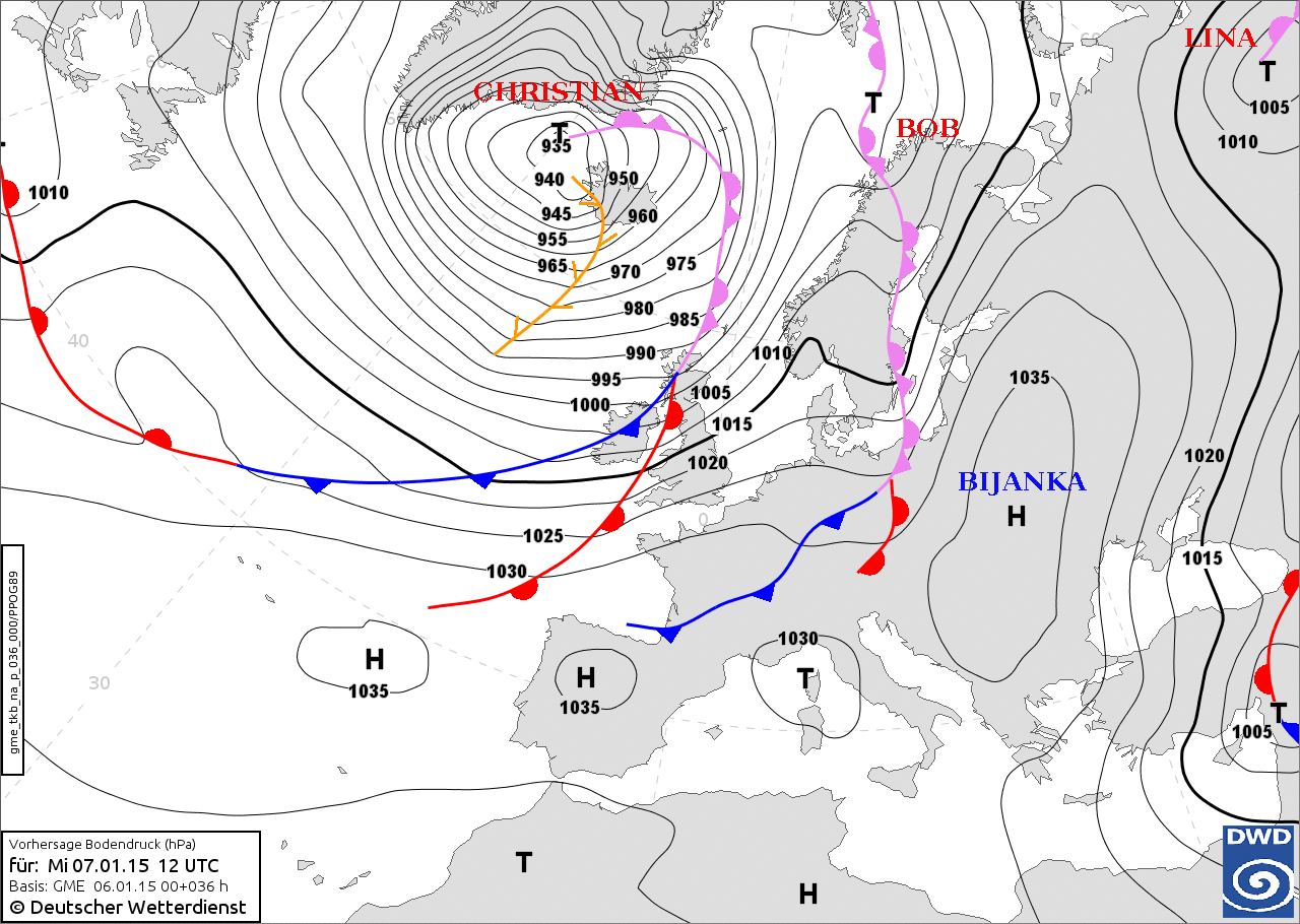
Met history

on 7 January pressure gradient between Portugal and Iceland of 100 hPa. [3] http://www.cazatormentas.net/el-anticiclonazo-puede-batir-registros-historicos-de-presion-atmosferica/
http://www.metoffice.gov.uk/climate/uk/summaries/2015/january
2 jan - http://cimss.ssec.wisc.edu/goes/blog/archives/17492
christian daniel, etc- http://www.unwetterzentrale.de/uwz/981.html
record high pressure over Portugal on 9th and low christian close to Iceland NAO index peak 8 January 1.871 [4]
cold early January in North America, 8 January Montpelier, Vermont had a record low of −20 °F (−29 °C), and Jackson, Kentucky was −1 °F (−18 °C). Schools closed in Portland, Maine and Chicago. In New York City the temperature was 9 °F (−13 °C). 2014–15 North American winter#Late December–early January cold
jet stream strengthened http://www.theweathernetwork.com/uk/news/articles/speedy-jet-stream-propels-planes-across-atlantic/43291/ 2014–15_North_American_winter
Elon (Dagmar)
http://www.vos.noaa.gov/MWL/201512/northatlantic.shtml Elon winds ascat img- http://www.washingtonpost.com/blogs/capital-weather-gang/wp/2015/01/12/harrowing-flight-landings-filmed-in-united-kingdom-and-germany-during-extraordinary-storm-video/ Elon (FUB), Dagmar (DMI http://www.dmi.dk/nyheder/arkiv/nyheder-2015/01/stormen-hedder-dagmar/ http://www.dmi.dk/nyheder/arkiv/nyheder-2015/01/foelg-vinden-med-dmi/), Nathan https://www.metcheck.com/UK/article.asp?ID=8793&Article=Storm+Nathan+%3A+100mph%2B+Winds
- http://www.dw.de/unseasonable-weather-warms-europe-freezes-eastern-mediterranean/a-18183518
- http://www.dmi.dk/nyheder/arkiv/nyheder-2015/01/dagmar-gav-storm-og-orkanstoed/
- https://www.youtube.com/watch?v=dBJp6SpfmCs&feature=youtu.be
- http://www.washingtonpost.com/blogs/capital-weather-gang/wp/2015/01/09/north-atlantic-storm-batters-northern-u-k-with-strongest-wind-gusts-in-over-50-years/
- http://www.bbc.co.uk/news/uk-scotland-highlands-islands-30726678?ns_mchannel=social&ns_campaign=bbc_weather&ns_source=twitter&ns_linkname=news_central
- http://www.washingtonpost.com/blogs/capital-weather-gang/wp/2015/01/09/north-atlantic-storm-batters-northern-u-k-with-strongest-wind-gusts-in-over-50-years/
- http://www.dailyrecord.co.uk/news/scottish-news/scotland-storm-thousands-homes-remain-4950960
- http://www.dmi.dk/nyheder/arkiv/nyheder-2015/01/dagmar-gav-storm-og-orkanstoed/
- http://www.spiegel.de/wissenschaft/natur/elon-und-felix-wetterdienste-verschaerfen-warnung-a-1012189.html
- http://www.spektrum.de/news/warum-folgt-sturm-auf-sturm/1326413
- http://actualite.lachainemeteo.com/actualite-meteo/2015-01-08-14h38/tempete-elon-en-europe---150-km-h-cette-nuit-27153.php
- http://news.yahoo.com/storm-causes-disruption-scotland-north-germany-171356409.html
Felix (Egon, Nina)
http://cimss.ssec.wisc.edu/goes/blog/archives/17553
Gust of 101 miles per hour (163 km/h) in Lerwick, Shetland. Days of continuous westerly winds led to a record high surge level at Lemvig on Limfjord, Denmark, [5] with 50 households evacuated. [6] 70,000 without electricity in Sweden. http://www.svt.se/nyheter/sverige/tusentals-hushall-stromlosa-efter-stormen-egon
http://www.bbc.co.uk/news/uk-scotland-highlands-islands-30759810 http://www.dmi.dk/nyheder/arkiv/nyheder-2015/01/egon-laegger-ud-med-storm-og-orkanstoed/ http://www.dmi.dk/nyheder/arkiv/nyheder-2015/01/weekendens-anden-storm-hedder-egon/ http://vejret.tv2.dk/artikel/id-74158201:ny-storm-egon-kan-skrive-historie-i-morgen.html https://www.ndr.de/nachrichten/Und-jetzt-kommt-Orkan-Felix,sturm1284.html DMI varsler forhøjet vandstand på 1,2-1,4 m over normalen. Det er langt fra niveauet under Bodil, men vi følger udviklingen nøje http://www.weathercast.co.uk/weather-news/news/ch/23e9d6bf790d149d78c4b6dee91bf0ed/article/uk_hit_by_storms.html http://artikkel.yr.no/sa-sint-var-nina-1.12143639 http://www.smhi.se/nyhetsarkiv/egon-sasongens-forsta-ordentliga-storm-1.83408 http://om.yr.no/2015/01/15/hvorfor-nina-var-sa-vrang/ http://www.smhi.se/nyhetsarkiv/storsta-inflodet-till-ostersjon-pa-20-ar-1.83689 http://www.sturmjaeger-nrw.de/kurze-synoptische-diskussion-zu-sturm-und-orkantief-felix/
Gunter II
945 Norwegian Sea https://xmetman.wordpress.com/2015/01/14/west-wind-doth-blow-and-we-shall-have-snow/
tornados haverfordwest, Harrow wintry weather pre-Herman http://www.washingtonpost.com/blogs/capital-weather-gang/wp/2015/01/14/heavy-snow-cripples-travel-in-northern-u-k-ireland-ahead-of-powerful-north-atlantic-storm/
Hermann
http://www.eumetsat.int/website/home/Images/ImageLibrary/DAT_2520477.html http://www.washingtonpost.com/blogs/capital-weather-gang/wp/2015/01/13/north-atlantic-bomb-cyclone-tracks-toward-ireland-u-k-threatens-hurricane-force-winds/
Ireland red weather alert for exposed coastal and mountain areas of Donegal, Sligo, Mayo, Galway, Clare, Limerick and Kerry - Status Orange wind warning for the rest of Ireland - Status Yellow rainfall warning for Connacht, Donegal, Clare, Cork, Kerry and Limerick- http://www.rte.ie/news/2015/0114/672601-live-caution-urged-after-status-red-weather-alert/ over egged- http://www.independent.ie/irish-news/one-killed-and-two-injured-as-storm-rachel-swept-across-the-country-30910420.html Met Éireann's Gerald Fleming says this will be as severe as many of last winter's storms although not as bad as 12 February.- http://www.rte.ie/news/2015/0114/672411-weather/ http://www.rte.ie/news/2015/0114/672411-weather/
2nd highest wave This buoy measured an individual wave of 16.9m at 10:00 on January 15th 2015, its second highest on record. The highest on record is a 19.1m wave recorded on January 27th 2013. In addition, the M2 buoy in the Irish Sea recorded an individual wave of 8.7m at 22:00 on 14 Jan 2015, slightly lower than its record of 8.98m on 27 December 2013. http://www.met.ie/news/display.asp?ID=303 http://www.irishtimes.com/news/environment/regional-round-up-west-coast-worst-affected-by-storm-rachel-1.2066934 http://www.bbc.co.uk/news/uk-northern-ireland-30864153 http://www.bbc.co.uk/news/uk-scotland-30803524
http://www.ouest-france.fr/tempete-hermann-premiers-degats-dans-le-finistere-et-le-morbihan-3116516 http://cimss.ssec.wisc.edu/goes/blog/archives/17553
http://www.weathercast.co.uk/weather-news/news/ch/0926b78cbfeb5fd2efc5dae517459752/article/batten_down_the_hatches.html
http://www.weathercast.co.uk/weather-news/news/ch/23e9d6bf790d149d78c4b6dee91bf0ed/article/uk_hit_by_storms.html
SSW
http://www.dmi.dk/nyheder/arkiv/nyheder-2015/01/foraar-i-stratosfaeren-truer-danmark-med-vinter
February
start large low pressure over Europe, Polar low, high pressure over UK by 7th high pressure building
Norbert
In Mediterranean region severe weather http://erccportal.jrc.ec.europa.eu/getdailymap/docId/1059
Ole (Othmar) Laina
Bodø cut-off as Tverlands bridge closed, several thousand without electricity. http://www.nrk.no/norge/na-herjer-_ole__-bodo-isolert-1.12194845 storm blew cladding off a hotel in central Bodø, leading police to close surrounding streets. http://www.nrk.no/nordland/stormen-blaste-veggplater-av-hotell-1.12194850 Moldjord shop partially lost roof. http://www.nrk.no/nordland/takplater-pa-coop-butikk-tatt-av-vinden-1.12195191
Laina, nothing like Tapani- http://www.iltalehti.fi/uutiset/2015020719159249_uu.shtml
- http://www.vg.no/nyheter/innenriks/vaer-og-uvaer/ole-tok-med-seg-garasjen/a/23391278/
- http://artikkel.yr.no/ekstremvaeret-satte-nye-vindrekorder-1.12196234
- http://www.maritime.no/nyheter/med-dette-vaeret-er-det-ingen-som-har-noe-pa-sjoen-a-gjore/
- http://www.tv2.no/2015/02/06/storm/ekstremvaeret-ole/vinter/ekstremvaer/6538761
- http://svenska.yle.fi/artikel/2015/02/08/blasigt-pa-land-och-till-sjoss
- http://www.iltalehti.fi/uutiset/2015020819162901_uu.shtml
- http://www.dr.dk/Nyheder/Indland/2015/02/07/154854.htm
- http://www.svd.se/nyheter/inrikes/orkanstyrka-nar-stormen-ole-drog-in-over-sverige_4317709.svd
Uli
Yoda
http://icelandmag.com/article/heavy-winds-blew-away-parts-cape-storhofdi-westman-islands-leaving-a-huge-rift http://icelandmag.com/article/january-and-february-windiest-months-20-years
March
Denis
7 march-
Niklas Information
Peak gusts...described as equivalent to a category 3 on the Saffir-Simpson scale. [7] but hurricane uses 10 minute or sustained... Even so, the wind speeds, compared to hurricanes were relatively low. As a result, AIR Worldwide predicted that average claims size will be smaller. But because the damaging winds had such a wide reach, the total claims are expected to be significant.- http://www.carriermanagement.com/news/2015/04/07/137773.htm
Elsewhere
http://www.westernmorningnews.co.uk/Gales-fierce-winds-70mph-batter-Britain/story-26262009-detail/story.html http://www.travelweekly.co.uk/Articles/2015/04/01/53687/gales+force+p.html
- http://www.spiegel.de/panorama/orkan-niklas-richtet-grosse-schaeden-an-a-1026729.html
- http://www.wunderground.com/blog/barbamz/comment.html?entrynum=65
- http://www.n-tv.de/wirtschaft/Niklas-belastet-das-Stromnetz-article14836716.html
- http://www.meteoschweiz.admin.ch/home/suche.html?query=Niklas
- http://www.poranny.pl/apps/pbcs.dll/article?AID=/20150401/POGODA/150409986
http://www.manager-magazin.de/unternehmen/energie/orkan-niklas-die-windkraft-und-power-to-heat-a-1026704.html http://www.windkraft-journal.de/2015/04/01/auswirkungen-des-sturmtiefs-niklas-auf-windenergieanlagen/ http://sputniknews.com/photo/20150401/1020298853.html
- http://www.rp-online.de/nrw/staedte/krefeld/orkan-niklas-reisst-voltaikanlage-von-dach-der-grotenburg-tribuene-aid-1.4987253
- http://www.metronieuws.nl/binnenland/2015/03/windvlaag-rukt-dak-van-rotterdams-flatgebouw-af
- http://www.spektrum.de/news/tief-niklas-stuermische-zeiten-bis-ostern/1340111
- http://www.knmi.nl/klimatologie/storm_310315.html
- http://www.knmi.nl/cms/content/122891/veel_overlast_door_lentestorm
- http://www.euronews.com/2015/04/01/hurricane-force-winds-batter-europe/
- http://www.gazettelive.co.uk/news/teesside-news/a19-standstill-after-lorry-overturns-8951636
- http://www.unwetterzentrale.de/uwz/lagebericht.html
- http://www.welt.de/vermischtes/article138983255/Orkan-Niklas-fordert-mehrere-Menschenleben.html
- http://www.bahn.de/p/view/home/info/sturm_15_03_31.shtml
- http://www.wetter24.de/news/detail/2015-03-31-kurzrueckblick-und-ausblick-sturm-orkan/
- http://www.thelocal.de/20150331/storm-shuts-down-nrw-train-lines
- http://www.bbc.co.uk/news/uk-england-london-32130848
- http://www.bbc.co.uk/news/in-pictures-32131049
- http://www.bbc.co.uk/news/uk-england-birmingham-32133368
- http://www.theweathernetwork.com/uk/news/articles/uk-weather/met-office-warns-of-severe-gales-as-wet-and-windy-weather-continues/48265/
- http://www.independent.co.uk/news/uk/home-news/uk-weather-windy-weather-batters-britain-overnight-with-storms-set-to-cause-travel-chaos-right-up-to-the-easter-weekend-10145532.html
- http://www.walesonline.co.uk/news/wales-news/wales-weather-brace-yourselves-more-8951497
- http://www.grimsbytelegraph.co.uk/Humber-Bridge-forced-close-van-blown/story-26260272-detail/story.html
- http://www.hulldailymail.co.uk/Humber-Bridge-closed-lorry-overturns-high-winds/story-26260442-detail/story.html
- http://www.theguardian.com/uk-news/2015/mar/31/met-office-issues-gale-warnings-for-much-of-uk
- http://www.dw.de/germanys-storm-niklas-one-of-the-biggest-in-years/g-18351411
- http://www.mirror.co.uk/news/world-news/hurricane-niklas-least-three-dead-5435646
- http://www.dw.de/niklas-in-germany-a-storm-of-tweets/a-18352160
- http://www.standaard.be/cnt/dmf20150331_01608181
- death nl http://www.rtlnieuws.nl/nieuws/binnenland/storm-dode-en-zwaargewonde-door-instorten-gebouw-ede
- 600 camp beds at schipol http://www.rtlnieuws.nl/nieuws/binnenland/stormachtig-einde-maart
- http://www.standard.co.uk/news/uk/powerful-winds-tear-off-roof-from-huge-building-at-silverstone-race-circuit-10146675.html
- http://www.standard.co.uk/news/london/london-weather-forecasters-issue-warning-of-damage-and-disruption-due-to-high-winds-10145143.html
- http://www.dailymail.co.uk/news/article-3019124/Britain-battered-100mph-winds-overnight-Atlantic-storms-set-crash-country-two-days.html
- http://www.thelocal.ch/20150331/niklas-sweeps-through-northern-switzerland
- http://www.br.de/nachrichten/unwetter-sturm-bayern-niklas-100.html
- http://www.dutchnews.nl/news/archives/2015/03/spring-storm-disrupts-roads-lead-to-flight-cancellations/
- http://www.dmi.dk/nyheder/arkiv/nyheder-2015/03/marts-slutter-hvidt-og-vaadt/
- http://www.meteofrance.fr/actualites/24072145-douceur-remarquable-sur-la-cote-d-azur
- http://www.kurzy.cz/zpravy/378552-zimu-prinesl-do-stredni-evropy-orkan-niklas-kdy-zeslabne/
- http://www.businessinsider.com/r-windstorm-niklas-to-cost-german-insurers-750-million-euros-body-2015-4?IR=T
- http://www.reuters.com/article/2015/04/23/idUSFWN0XK04720150423
April mountain winstorm Sweden
När det gäller stationer på fjälltoppar så är rekordet 41 m/s i medelvind vid Stekenjokk den 4 april 2007. Från svenska kuststationer finns bara ett exempel på orkanvindar i april månad. Det var 33 m/s vid Söderarm den 14 april 1981. http://www.smhi.se/bloggar/vaderleken/2015/04/20/full-orkan-i-fjallen/
1987
http://nora.nerc.ac.uk/6938/1/HDUK87.pdf hydrology year 1987
Flooding in Wales and Glanrhyd Bridge collapse
In the days following the Great Storm the moist air flow behind brought high rainfall to Wales, resulting in flooding on the River Towy and Carmarthen, leading to the fatal Glanrhyd Bridge collapse.
2015 Australian east coast lows Information
- http://www.weatherzone.com.au/news/
- http://www.weather.com/news/news/australia-storm-sydney-new-south-wales-flooding
- http://www.9news.com.au/national/2015/04/21/05/54/nsw-coast-lashed-by-wild-storms
- http://theconversation.com/explainer-the-wild-storms-that-lash-australias-east-coast-40564
- http://thewatchers.adorraeli.com/2015/04/21/explainer-the-wild-storms-that-lash-australias-east-coast/
- http://www.swellnet.com/news/swellnet-analysis/2015/04/20/when-east-coast-low-not-east-coast-low
- http://time.com/3829325/australia-weather-storm-dungog-flood-house-video-sydney-nsw/
- http://www.bbc.co.uk/news/world-australia-32407859
- http://www.bbc.co.uk/weather/features/32401966 no sound
- http://www.insuranceinsider.com/new-south-wales-storms-declared-a-catastrophe
- http://blog.metoffice.gov.uk/2015/04/22/intense-storm-threatens-sydney/
- http://www.meteofrance.fr/actualites/24516466-pluies-diluviennes-sur-le-sud-est-de-l-australie-les-20-et-21-avril
- http://earthobservatory.nasa.gov/NaturalHazards/view.php?id=85743&eocn=home&eoci=nh
- http://www.telegraph.co.uk/news/worldnews/australiaandthepacific/australia/11557633/Time-lapse-shows-Sydney-train-station-disappear-under-floodwater-in-45-minutes.html
- Coal mining 80 years - http://www.miningaustralia.com.au/news/hunter-valley-storm-forces-coal-mines-to-close
New South Wales east coast low
 Suomi NPP satellite image of east coast low 21 April 2015 | |
| Type | Australian east coast low, Extratropical cyclone, Winter storm |
|---|---|
| Formed | April 20, 2015 |
| Dissipated | April 22, 2015 |
| Highest gust | 135 km/h (84 mph) |
| Lowest pressure | 1,009 mb (29.8 inHg) |
| Fatalities | at least 8 [9] |
| Areas affected | New South Wales, Australia. |
The New South Wales east coast low was a severe
extra-tropical cyclone that affected the state between 20–22 April
Meteorological history

was an area of low pressure aloft that became trapped to the north of the active jet stream.
[10] That trapping led to the slow movement of the storm.
[10] This closed-off upper-level low then induced a low-pressure center just off the New South Wales coast.
[10] The pressure gradient between that surface low and high pressure centered near Tasmania and the Tasman Sea lead to the intense onshore winds.
[10]
strong pressure gradient between high pressure of 1037mb over Tasmania and the Australian Bight strong winds blowing onshore orographic precipitation component to rainfall as moist flows onto land uplifted as crossed over land and forced up Great Dividing Range. [10]
Impact
<---Over the last few days, strong winds and heavy rainfall from an intense low pressure system have impacted eastern portions of New South Wales (NSW), including the capital city Sydney (pop. ~ 4.8 million), the Central Coast, and the Hunter Region, which has damaged homes, caused thousands of power outages, transport disruption, and four fatalities. The BoM also reported that eastern portions of NSW were impacted by wind gusts of up to 85 mph (135 km/hr) on Monday.
New South Wales State Emergency Service responded to 20,648 calls from the event, including 170 flood rescues. [11]
At the height of the storm, strong winds downed trees and power lines causing over 215,000 power outages in Sydney, the Central Coast, and the Hunter Region. Four major power lines have since been restored, though approximately 155,000 power outages remain in effect as of Thursday April 23.
Sydney saw 38 hours with sustained winds over 30 miles per hour and frequent gusts over 50 mph from mid-afternoon 20 April to early morning on 22 April. [10] The storm disrupted electricity to 215,000 customers, the largest outage since the 2007 east coast low. [12]
3rd "catastrophe" of year following Cyclone Marcia and the 2015_Sampson_Flat_bushfires of South Australia by the Insurance Council of Australia. [13]
Erosion
Bondi Beach sand blown from the beach onto the shore and bury skatepark. Coogee Beach 12 large earth movers, two vacuum trucks and a crew of 35 worked to restore the beach, Up to 2,500 tonnes of sand had been violently churned up and displaced by Sydney's record-breaking storms, stripping the beach and dumping 400-500 tonnes over nearby parks and roads. [14] Narrabeen Beach saw erosion described as 1 in 20 year event, as the beach eroded some 25m landwards/ The 14.9-metre wave recorded offshore eclipsed the previous high of 14.1 metres set during the 2007 east coast low /offshore buoy also recorded 30 consecutive hours of significant waves heights above six metres, up until 1am on Wednesday. That length easily beat the previous record of 24 hours set during the Mother's Day storm of May 1997, Mr Couriel said, citing data going back to 1987. [15]
Rainfall and flooding
According to the Bureau of Meteorology (BoM), at the height of the storm on Monday April 20, rainfall accumulations of 4.7 in (120 mm) were recorded over a period of 24 hours across the affected areas, including Sydney, while rainfall accumulations reached 12.2 in (312 mm) in Dungog over the same time period. Twelve areas along the NSW coastline, between the cities of Newcastle (pop. ~ 308,000) and Sydney, have been declared natural disaster zones, which means that hardship payments and emergency assistance can be deployed quickly to these areas. In the south-western districts of Sydney, over 200 homes were evacuated as heavy rainfall caused the Gorges River to burst its banks, flooding the surrounding towns southwest of Sydney.
225mm rain fell in Sydney over the last 2 days, the wettest 2-day period since and east coast low on 7-8 August 1998. [10]Wettest April in 26 years in Sydney with almost triple the average monthly rainfall, Sydney saw the most rain over two day period in 17 years. [11]
Reports indicate that the town of Dungog was one of the worst areas affected by flooding, with dozens of homes damaged and four homes destroyed. The town of Dungog (pop. ~2,100), located approximately 100 mi (160 km) north-northeast of Sydney appears to the worst area affected by flooding, with dozens of homes damaged and four homes destroyed. Homes were swept away as over 12 inches (312 millimeters) of rain in just 24 hours swamped the town of about 2,100 residents 135 miles north of Sydney, according to the Australian Bureau of Meteorology (BoM)."To give you a sense of the size and scope, in Dungog, there's more rain that has come down in the last 24 hours than they have seen in a 24-hour period for the past century," according to NSW premier Mike Baird. [10] local government urged residents of Dungog to evacuate to a local high school, if possible, due to the severe flooding. [10]
Transport
Dozens of international flights to Sydney Airport were diverted to Brisbane and many outbound flights faced disruptions, as strong winds created hazardous flying conditions. Large swells caused ferry services at Sydney Harbour to be disrupted, with some cruise liners and ships waiting up to 48 hours to dock, as the harbour closed.
Newcastle port, the world’s biggest marine coal export terminal, was closed due to the storm. [16]
Manly_ferry_services, [12] Services on the South_Coast_railway_line,_New_South_Wales South Coast train line have also been cancelled between Oak Flats and Kiama. [12] Hunter line closed
Over 180 schools in the region closed during the storm.
Casualties
Three deaths were of elderly people trapped in their homes by quickly rising floodwaters (in Dungog) 2 veterans one elderly woman and woman in car near Maitland in the Hunter region when the car was swept off the road.- http://www.abc.net.au/news/2015-04-24/thousands-still-without-power-as-more-ses-workers-flown-in/6417386
Aftermath
The insurance industry quickly declared a "catastrophe" after receiving a deluge of claims from across the Sydney metropolitan area, the NSW Central Coast of and the Hunter.
The Insurance Council of Australia reported that over 24,400 claims relating to the storms have been lodged across NSW, mostly relating to low-level property damage from water and wind damage, and damage to cars, though some claims relating to severe damage to houses and roofs and storm-water inundation have been lodged.
Initial losses of the order of $129 million were estimated. with the number likely to rise as policyholders continue to claim. [17]
The insurance claims though are short of some other extreme weather events Sydney has previously experienced, following the 1999 Sydney hailstorm the industry paid out claims worth $1.7 billion, which the Insurance Council of Australia says would be equivalent of $4.3 billion in today's dollars.
Prices for coal cargoes delivered from Newcastle increased more than 10 percent during the storm as traders expected export delays due the ports closure. [16]
shared images of discarded broken umbrellas around Sydney on social media termed "Great Umbrella Massacre". [18] under the hashtag #BinsofSydney- http://www.weatherzone.com.au/news/binsofsydney-storm-ravaged-bins-umbrellas-light-up-social-media/281067
Ausgrid deployed more than 1600 workers into the field to clean up after the disaster, including emergency officers, line workers, pole crews and tree trimmers. https://www.ausgrid.com.au/Common/Customer-Services/Storm-updates/News-update-2604-11pm.aspx https://www.ausgrid.com.au/Common/Customer-Services/Storm-updates.aspx A week after the storm abated Ausgrid were still working to connect 5500 customers in the Hunter and 2000 on the central coast who have been without power since the storm. [11]
Insurance Australia Group announced initial expected net costs of A$250 million from the NSW storm damage and about $50 million from the Sydney hailstorm. [19]
Subsequent weather
Sydney Anzac Day hailstorm
25 April Anzac Day hailstorm crossed the city on Saturday afternoon. [20] Moved through outer western suburbs and Penrith,_New_South_Wales intense storm passed over some suburbs of the city causing severe damage while others were barely affected. Huntingwood where the roofs of two factories at the Bungarribee Industrial Estate collapsed under the weight of hail.
moving eastwards to Sydney's inner west suburbs of Newtown, Erskineville and St Peters which saw some of the fiercest hail. [20]
16,311 strikes (including cloud-to-cloud and cloud-to-ground strikes) were recorded as the storm passed over the city, more than twice as many as seen during the stormy weather from the east coast low. [20]
Claims pass AUD$60m [13]
4th declared "Catastrophe" in Australia in 2015. [13] 2014_Brisbane_hailstorm
Queensland & NSW east coast low
 True color imagery from the Suomi NPP satellite's Visible Infrared Imaging Radiometer Suite (VIIRS) instrument 1 May 2015 | |
| Type | Australian east coast low, Extratropical cyclone, Winter storm |
|---|---|
| Formed | May 01, 2015 |
| Dissipated | May 02, 2015 |
| Highest gust | 100 km/h (62 mph) Moreton Island |
| Lowest pressure | convert: needs a number |
| Fatalities | at least 6 [21] |
| Areas affected | Queensland, New South Wales, Australia. |
Another feature of east coast low development is the tendency for clustering of events when conditions remain favourable. For example, near Brisbane, almost one third of events occur within 20 days of a preceding event. [22]
Correlations of east coast cyclones with the interannual differences of the El Niño–Southern Oscillation indicate a strong preference for these storms to form just after a large swing from negative to positive Southern Oscillation index values and especially between swings from negative SOI the year before and positive SOI the year after. This suggests a preference for formation of east coast cyclones between extreme events of the Southern Oscillation Index. [23]
Australian Bureau of Meteorology http://media.bom.gov.au/releases/161/bureau-monitoring-the-potential-for-another-east-coast-low-to-develop/ 28 April The bureau’s NSW weather services manager, Andrew Treloar, said significant rainfall could bring a fresh round of flooding. It was expecting “less prolonged gales” than in the previous storm, but further wind damage could not be ruled out. http://www.theguardian.com/australia-news/2015/apr/28/more-nsw-storms-coming-as-heavy-rain-and-wind-forecast-for-northern-coast
1 May east coast low heavy rainfall and subsequent flooding to se Queensland. 106 homes flooded Deception Bay and Rothwell, 20 mi (30 km) north of Brisbane. The flooding resulted in five fatalities, all as a result of driving cars through floodwaters.
Bureau of Meteorology (BoM) reported several weather stations with daily rainfall totals of nearly 11.8 in (300 mm), including Deception Bay which recorded 11 in (278 mm), with much of the rainfall falling within a three hour period In Brisbane, Queensland’s capital, 7.2 in (183 mm) of rainfall fell on Friday, becoming the wettest May day on record at the Brisbane Regional Office. The previous record was 5.87 in (149 mm) on May 9, 1980. Brisbane averages nearly 2.90 in (74 mm) during the entire month of May The state government has offered immediate financial support to residents in many of the affected streets.
The Insurance Council of Australia (ICA) has described the event as a “catastrophe” – the fifth catastrophe declared by the ICA this year. To date, about 7,500 claims have been received by insurance companies - See more at: http://www.rms.com/Catastrophe/Catupdates/CatSummary?event_id=4686#sthash.nwi0VVmQ.dpuf fifth catastrophe of 2015 declared by ICA. [24]
Meteorological History
developed trough in jet stream. [25]
Impact
Caboolture 330mm of rain in 24 hours, 277mm falling in just 3 hours. [25]
- http://thewatchers.adorraeli.com/2015/05/02/deadly-floods-hit-queensland-277-mm-of-rain-in-3-hours-australia/
- http://media.bom.gov.au/releases/163/queensland-to-feel-the-brunt-of-east-coast-low-today/
- http://www.weatherzone.com.au/news/how-the-east-coast-lows-compare/286666
- http://www.theguardian.com/australia-news/2015/may/03/storm-damage-evacuations-in-sydney-as-queensland-and-nsw-forecasts-clear
- http://www.news.com.au/national/queensland/queensland-storm-premier-annastacia-palaszczuk-activates-immediate-hardship-fund-following-one-in-2000-year-storm/story-fnii5v6w-1227333069580
- http://www.heraldsun.com.au/news/national/five-die-as-cars-washed-away-in-wild-southeast-queensland-weather/story-fnmd9gni-1227331087209
- http://www.couriermail.com.au/news/queensland/three-killed-after-wild-weather-lashes-southeast/story-fnkt21jb-1227329174826
- http://www.accuweather.com/en/weather-news/five-dead-in-australia-as-exce/46481436
- http://www.couriermail.com.au/news/queensland/three-killed-after-wild-weather-lashes-southeast/story-fnkt21jb-1227329174826
- http://www.keraunos.org/actualites/fil-infos/2015/mai/pluie-inondations-crue-alpes-cyclone-quang-australie-bilan-tornade-etats-unis.html
== Information
NSW east coast low 68,243 claims and estimated loss of $301 million Anzac 19,000 claims and $125 million loss Qnslnd & nNSW 7500 claims and loss of $26 million. [24]
References
- ^ "Deadly floods in France and Italy". EuroNews. 16 November 2014. Retrieved 23 November 2014.
- ^ a b c Huet, Sylvestre (14 October 2014). "Episode Cévenol: L'Explication de Météo France". Sciences.blogs.liberation.fr. Retrieved 14 October 2014.
- ^ "Synoptic 7 January 2015". Adopt-A-Vortex. Free University Berlin. Retrieved 21 June 2015.
- ^ "North Atlantic Oscillation". Climate Prediction Centre. National Weather Service. Retrieved 21 June 2015.
- ^ Siewertsen, Bjarne (11 January 2015). "Record high water levels after Dagmar and Egon" (in Danish). DMI. Retrieved 11 January 2015.
- ^ "Oversvømmelse: Borgere evakueres" (in Danish). Lemvig Kommune. 11 January 2015. Retrieved 11 January 2015.
- ^ Caridi, Peppe (31 March 2015). "La tempesta Niklas come un uragano di 3^ categoria: Europa devastata, morti e feriti. Allerta in Italia" (in Italian). MeteoWeb.eu. Retrieved 1 April 2015.
- ^ Houghton, J. T. (March 1988). "The Storm, The Media and the Enquiry". Weather. 43 (3): 67–70. doi: 10.1002/j.1477-8696.1988.tb03883.x. Retrieved 23 July 2015.
- ^ Michael, Sarah; McNab, Heather (21 April 2015). "Woman's body retrieved from car swept away by raging waters - bringing death toll to EIGHT - as Sydney river bursts its banks and photos of mass destruction emerge from the eye of the storm". Daily Mail. Retrieved 29 April 2015.
- ^ a b c d e f g h i Erdman, Jon (22 April 2015). "Australia Storm Hammers Sydney, New South Wales; 3 Dead, Hundreds Evacuated as Flooding Washes Away Homes". The Weather Channel. Retrieved 26 April 2015.
- ^ a b c Hannam, Peter (29 April 2015). "Sydney weather: More rain to cap wettest April in 26 years as new threat looms". Sydney Morning Herald. Retrieved 29 April 2015.
- ^ a b c "Australia: Deadly storm continues to hammer NSW". Weatherwatch. 21 April 2015. Retrieved 26 April 2015.
- ^ a b c "Sydney Anzac Day hailstorm claims pass $60m" (PDF). Insurance Council of Australia. 1 May 2015. Retrieved 9 May 2015.
- ^ Aubusson, Kate (24 April 2015). "Excavators take over Coogee Beach clean-up". Sydney Morning Herald. Retrieved 29 April 2015.
- ^ Aubusson, Kate; Hannam, Peter (23 April 2015). "Sydney weather: waves break records as erosion sees Narrabeen retreat 25 metres during storm". Sydney Morning Herald. Retrieved 29 April 2015.
- ^ a b "Australia's Newcastle coal port to reopen after storm". Hellenic Shipping News. Reuters. 24 April 2015. Retrieved 26 April 2015.
- ^ Matt Wade (April 22, 2015). "Sydney storm: How much will the Sydney storm cost?". Brisbane Times. Retrieved April 22, 2015.
- ^ Sainty, Lane (21 April 2015). "24 Pictures That Define The Great Umbrella Massacre Of 2015". Buzzfeed. Retrieved 26 April 2015.
- ^ "IAG lowers insurance margin guidance after storm lashes Australia". Reuters. 29 April 2015. Retrieved 29 April 2015.
- ^ a b c "How a hail storm lanced the heart of Sydney". Sydney Morning Herald. 27 April 2015. Retrieved 28 April 2015.
- ^ "Six dead after brutal storms lash south-east Queensland and north NSW coast". 9 News. 2 May 2015. Retrieved 3 May 2015.
- ^ Harper, Bruce; Ken Granger (2000). "Chapter 5: East coast low risks". In K. Granger & M. Hayne (ed.). Natural hazards and the risks they pose to South-East Queensland (PDF). Australian Geological Survey Organisation in conjunction with Bureau of Meteorology. ISBN 0642467080. Retrieved 7 April 2013.
- ^ Hopkins, Linda C.; Holland, Greg J. (1997). "Australian Heavy-Rain Days and Associated East Coast Cyclones: 1958–92". Journal of Climate. 10 (4): 621–635. doi: 10.1175/1520-0442(1997)010<0621:AHRDAA>2.0.CO;2. Retrieved 7 April 2013.
- ^ a b "ICA declares fifth catastrophe for 2015" (PDF). Insurance Council Australia. 4 May 2015. Retrieved 9 May 2015.
- ^ a b "Storms hit east coast Australia". BBC Weather. 2 May 2015. Retrieved 3 May 2015.
External links
Notable periods
- Snow 1947, 1963, 2010
- individual snowfall
- Storm 1987 1990 1976
- surge 1953, 1978, 2013
- heat-wave 1976, 2003
- flood
- 2013/14, 2012, 2000
- flash boscastle, summer 2012, 1968
- fog Pea_soup_fog Great_Smog 1952, Clean_Air_Act_1956
- icing
2013-2014
http://www.environ.ie/en/Publications/Community/FireandEmergencyServices/FileDownLoad,36547,en.pdf
Germany tornado Information
North Germany tornado outbreak, 2 tornadoes were confirmed in Mecklenburg-Vorpommern the towns of Bützow and in Kreien. Trees were uprooted or snapped, houses lost their roofs and windows. A car was flipped over and dragged 70m. [1]
saw an area of severe weather move across France? Netherlands and Northern Germany into Denmark and southern Sweden.
DWD report [2]
The town of Bützow Tornado is classified as a so-called F3. This means that the wind in the rotary motion reaches over 70 m/sec or 250 km/h. [3]

plume-artig type of development, possibly MCS warm, moist air from sirrocco fr maghreb
- http://www.accuweather.com/en/weather-news/severe-storms-to-threaten-pari-1/46624639
- http://www.rms.com/Catastrophe/Catupdates/CatSummary?event_id=4690
- http://www.keraunos.org/actualites/fil-infos/2015/mai/tornade-allemagne-typhon-noul-micronesie-possible-phenomene-subtropical-precoce-atlantique.html
- http://www.keraunos.org/actualites/fil-infos/2015/mai/orages-4-mai-2015-suivi-grele-rafales-de-vent-aquitaine-poitou-centre-ile-de-france.html
- http://www.wetter24.de/news/detail/2015-05-06-tornado-in-buetzow-und-umgebung/
- BBC Weather @bbcweather 7h7 hours ago
EUROPE: Over 230,000 #lightning flashes reported yesterday. Most being over Netherlands, Denmark, N Germany. MattT
- http://www.weather.com/news/news/northern-germany-tornadoes-wind-damage
- http://www.dw.de/tornado-devastates-b%C3%BCtzow-in-northern-germany/a-18430793

Denmark saw torrential rain mainly across Jutland saw 15 to 20mm of rain fall in 30 minutes in some locations. [4] Varmen trækkes op af et kraftigt lavtryk nær De Britiske Øer. Det pumper varm og fugtig luft fra Sydeuropa op til vore breddegrader.
Der er endnu noget usikkert, hvor meget vand, der bliver vredet ud af de kraftige byger, men generelt falder der et sted mellem 10 og 20 mm. I de sydvestlige og østlige egne af landet kan man lokalt opleve op mellem 25-35 mm, og dermed er der risiko for lokale skybrud eller for kraftig regn.
Såfremt der skulle blive målt skybrud tirsdag, vil det være første gang i 2015, men helt sikkert ikke sidste gang. [5]
Europe heat wave
- http://www.ctvnews.ca/world/france-u-k-issue-warnings-as-temperatures-soar-to-unusual-levels-1.2446989
- http://www.wunderground.com/blog/JeffMasters/comment.html?entrynum=3029&cm_ven=tw-jm
30 June 1900:Extreme high temperature in France (Ain, Aisne, Allier, Aube, Cantal, Cher, Corrèze, Côte d'Or, Creuse, Dordogne, Doubs, Essonne, Haute Loire, Haute Marne, Haute Saône, Haute Vienne, Indre, Jura, Loire, Loiret, Lot, Lot et Garonne, Marne, Meurthe et Moselle, Meuse, Nièvre, Nord, Paris et Petite Couronne, Puy de Dôme, Rhône, Saône et Loire, Seine et Marne, Territoire de Belfort, Val d'Oise, Vosges, Yonne, Yvelines), Spain (Álava, Ávila, Badajoz, Bizkaia, Burgos, Cáceres, Ciudad Real, Córdoba, Cuenca, Gipuzkoa, Granada, Guadalajara, Huesca, Jaén, La Rioja, Lleida, Madrid, Navarra, Teruel, Toledo, Valladolid, Zaragoza) - Orange Alert
- http://mashable.com/2015/07/01/england-france-spain-heat-wave/
- http://www.weather.com/forecast/news/europe-heat-wave-record-highs-june-july-2015?cm_ven=Twitter_TheWeatherChannel_Weather_JWa_Article_No_5_20150630
- http://thewatchers.adorraeli.com/2015/06/30/intense-heat-wave-spreading-through-europe-temperatures-rising-above-40-c/
- hottest July day record broken
- Railway derailment Lincoln
- possible supercell Harrogate-Newcastle afternoon of 1 July (flooding, school, housefires) and second evening (large hail)
- http://www.cpc.ncep.noaa.gov/products/JAWF_Monitoring/Europe/temperature.shtml
- http://www.bbc.co.uk/blogs/paulhudson/entries/61e7580c-3ebf-43b5-bcdc-9c0a5bb700ce
- http://www.euronews.com/2015/06/30/western-europe-sizzles-in-first-heatwave-of-summer-with-no-end-in-sight-for/
- Paul Hudson @Hudsonweather 2h2 hours ago
Paris reached 39.7C (103F) this afternoon, 2nd hottest temperature in ANY month, in records back to 1873.
- thunder in Faroes
- Météo-France @meteofrance 14m14 minutes ago View translation
Records pr un mois de juillet aujourd'hui à Epinal (35,6°C), Langres (35,3°C), approchés à Strasbourg (37,2°C), Nancy (37,0°C) #canicule
- http://www.metoffice.gov.uk/news/releases/archive/2015/hot-july
- Royal Met. Soc. @RMetS 12s12 seconds ago
Royal Met. Soc. retweeted Etienne Kapikian Hot in Holland: 38.2c in Maastricht on 02/07/15, new national record for July (former: 37.1 in 2006 in Westdorpe)
White Friday 2003
Jan 31 2003
|style="background:rgb(255,225,225);"| Ole ||
References
- ^ http://www.bild.de/news/inland/wetter/wetter-kurz-sommer-und-gewitter-dann-kracht-es-bei-mir-40821832.bild.html
- ^ Haeseler, Susanne; Lefebvre, Christiana; Friedrich, Andreas (6 May 2015). "Unwetter mit Tornados richten am 5. Mai 2015 schwere Schäden in Norddeutschland an" (PDF) (in German). Deutscher Wetterdienst. Retrieved 7 May 2015.
- ^ Hansen, Niels (8 May 2015). "Se den vilde nordtyske tornado" (in Danish). Danish Meteorological Institute. Retrieved 14 May 2015.
- ^ Brandt, Marianne (6 May 2015). "Her ramte tirsdagens skybrud" (in Danish). Danish Meteorological Institute. Retrieved 14 May 2015.
- ^ Skelbæk, Michael; Brandt, Marianne (4 May 2015). "Tirsdag med tre slags regn" (in Danish). Danish Meteorological Institute. Retrieved 14 May 2015.