
Xaver
[1] http://www.dwd.de/bvbw/generator/DWDWWW/Content/Oeffentlichkeit/KU/KU2/KU24/besondere__ereignisse__global/stuerme/201312__XAVER__europa,templateId=raw,property=publicationFile.pdf/201312_XAVER_europa.pdf
Scotland
River Ness in Inverness and River Dee in Aberdeen burst their banks [2] Banff, Scotland Community centre evacuated as roads cut off by waters. [3]
Overtopping and defence failure on Yare to west of Norwich Seahouses http://www.geograph.org.uk/photo/3772539 Ferriby http://www.geograph.org.uk/photo/3771916 Breached Seawall http://www.geograph.org.uk/photo/3778734 There are 130 members of the Civil Defence and 30 soldiers deployed 25,000 sandbags to explain and take other preventive measures, according to Minister of Interior Joëlle Milquet ( CDH ) helped prevent serious damage. [10]
The Belgian Management Unit of the North Sea Mathematical Models on 4 December 2013 gave a severe storm surge warning from Thursday 05/12 afternoon until Friday 06/12 noon, a severe storm with northwesterly winds locally reaching 11 to 12 Bft will strike the whole North Sea and push seawater towards the Belgian coastline. Depending on the meteorological forcing used, our models currently forecast high waters ranging between 6.01m and 6.35m TAW at Ostend on Friday 6/12/2013 03:00 local time (02:00 UTC). In comparison, the high water during the historical storm of 31/01/1953 and 01/02/1953 was estimated at 6.66m TAW at Ostend. On the basis of our forecasts and those of the OMS station, the Flemish administration MDK issued an official bulletin for dangerous storm surge. [4]
North East England http://www.thenorthernecho.co.uk/news/10863405.One_flood_warning_still_in_place_as_clean_up_continues/ http://www.thenorthernecho.co.uk/news/local/teesvalley/middlesbrough/10860422.Homes_and_businesses_flooded_as_storm_surge_strikes_North_East_communities/ http://www.darlingtonandstocktontimes.co.uk/news/10860422.Homes_and_businesses_flooded_as_storm_surge_strikes_North_East_communities/
Scarborough and Filey initial estimates of costs £1 million to council. [5]
Spurn point lifeboat station and humber pilot likely to be without mains power until March 2014, with crews having to travel to Grimsby on the south bank of the Humber for crew changes, after an 800m section of the peninsular and road was breached by the storm, and road washed away. [6]
Damage estimated to cost North Norfolk over 1 million GBP major damage to sea walls at Sheringham, Mundesley, Walcott and Bacton. [7]
http://www.smhi.se/nyhetsarkiv/stormen-sven-gav-nya-vattenstandsrekord-i-oresund-1.34732 http://www.smhi.se/nyhetsarkiv/sven-var-forhallandevis-extremast-vid-bohuskusten-1.34671
Wind
Wind power
http://www.businessweek.com/news/2013-12-05/near-record-wind-helps-renewables-supply-a-third-of-german-power http://cleantechnica.com/2013/12/20/germany-ireland-uk-set-new-wind-generation-records/
record surge and negative surge in oresund http://www.smhi.se/nyhetsarkiv/stormen-sven-gav-nya-vattenstandsrekord-i-oresund-1.34732?search=yes&month=12&year=2013 http://www.smhi.se/nyhetsarkiv/sven-var-forhallandevis-extremast-vid-bohuskusten-1.34671?search=yes&month=12&year=2013 http://www.stormraadet.dk/Storm/Pressemeddelelser/Stormflod-56-december-2013?tc=254E0607442147E49EF582D56C8FC906 http://www.dmi.dk/nyheder/arkiv/nyheder-2013/12/stormraadet-der-var-stormflod-i-december/ http://www.dmi.dk/nyheder/arkiv/nyheder-2013/12/saadan-varslede-dmi-forhoejet-vandstand/ http://www.dmi.dk/nyheder/arkiv/nyheder-2013/12/sjaelden-stormflod-under-opsejling/ http://www.dmi.dk/nyheder/arkiv/nyheder-2013/12/dmis-modeller-havde-luret-bodil/ http://www.dmi.dk/nyheder/arkiv/nyheder-2013/12/bodil-klassificeret-som-orkanlignende/ http://www.dmi.dk/nyheder/arkiv/nyheder-2013/12/saadan-varslede-dmi-stormen-bodil/ http://www.dmi.dk/nyheder/arkiv/nyheder-2013/12/bodil-har-toppet/ http://www.dmi.dk/nyheder/arkiv/nyheder-2013/12/status-paa-bodil/
island of Sylt cut off
Along the German coast East Frisian and North Sea coast sea levels to 3m above datum.
Cryosat measure surge in Kattegat. [9]
The Royal National Lifeboat Institution (RNLI) lifeboat station in Wells was flooded during yesterday's storm surge. It was one of nine RNLI lifeboat stations flooded or damaged by the weather. [10]
Bernd
It will become stormy later today and for a time tonight, in coastal counties of Connacht and west Ulster, with severe southwest winds with mean speeds of 70 to 90km/h and damaging gusts of 120 to 150km/h, strongest in exposed coastal areas. Very high seas also.
Issued:Wednesday 18 December 2013 09:00 Valid:Wednesday 18 December 2013 15:00 to Thursday 19 December 2013 03:00
STATUS ORANGE
Wind Warning for Cavan and Clare It will become stormy for a time later this afternoon and evening, with severe southwest winds, gusting 100 to 120 km/h, strongest in exposed areas.
Issued:Wednesday 18 December 2013 10:00 Valid:Wednesday 18 December 2013 15:00 to Wednesday 18 December 2013 23:59
STATUS YELLOW
Wind Warning for Leinster, Monaghan, Roscommon, Tipperary and Waterford Very windy later this afternoon and evening with very strong and blustery south veering southwest winds and gusts of 90 to 110km/h Valid 1500 to 2400h
Issued:Wednesday 18 December 2013 10:00 Valid:Wednesday 18 December 2013 15:00 to Wednesday 18 December 2013 23:59
Norwegian_Meteorological_Institute Torsdag morgen og formiddag ventes det sterk vind på kysten og utsatte steder i Rogaland, Hordaland og Sogn og Fjordane. Risiko for høy vannstand i Sogn og Fjordane. Kraftig vind fra sørøst i fjellet. Rogaland:Torsdag morgen og formiddag ventes det søraust liten og kan hende full storm på kysten og i fjellet. Det ventes også vindkast på omkring 20-25 m/s i innlandet. Hordaland: Torsdag morgen og formiddag ventes det søraust liten og kan hende full storm på kysten og i fjellet. Det ventes også vindkast omkring 20 m/s i innlandet. Sogn og Fjordane:Torsdag morgen og formiddag ventes det sør-søraust liten storm på kysten og i fjellet i sør. Det ventes også vindkast på omkring 15-20 m/s i innlandet. Varsler for strekningen Fedje til Stad: Risiko for høy vannstand, estimert til ca 50 cm over høyden oppgitt i tidevannstabellene, er ventet sent torsdag formiddag. Mer informasjon om tidevann og vannstand finnes på sehavniva.no Oppland og Sør-Trøndelag: Fra tidlig torsdag morgen sørøst periodevis liten storm i fjellet. Torsdag ettermiddag minkende.
UK Met Office Issued at: 1059 on Wed 18 Dec 2013
Valid from: 2100 on Wed 18 Dec 2013
Valid to: 0800 on Thu 19 Dec 2013
Severe gale force winds will affect parts of Northern Ireland, western, central and northern Scotland. A swathe of storm force winds will progress northwards with time, perhaps clipping the far north of Northern Ireland before moving north to affect the western Isles and skirting western and northwestern fringes of mainland Scotland.
Gusts of 70 to 80 mph are expected within the Amber warning area, and to around 90 mph in some of the more exposed locations in western Scotland and the Western Isles. Such winds will lead to very large waves with some coastal over-topping likely. Some heavy rain is also expected. The rain and the strongest winds will clear early on Thursday, giving way to blustery and wintry showers.
The public should be prepared for disruption to transport and possibly power supplies. A rapidly deepening area of low pressure will pass close to northwest UK later on Wednesday and during the first part of Thursday. There is still some uncertainty about the exact track of the swathe of strongest winds and peak gusts, but in combination with heavy rain and some coastal flooding, the storm has the potential to bring some significant disruption.
Electricity generation
Dirk
Jet stream though powerful was less strong than 1999, [11] Lothar and Martin formed relatively close to European landmass under 360 [12]-400km/h [11] linear jet stream, which directed storms straight over Europe in 1999 was now curved directing lows to north of Scotland. [11]
Comparison to NZ Storm
/info/en/?search=User:Lacunae/14 2013 New Zealand winter storm http://www.standard.co.uk/business/business-news/hong-kong-billionaire-li-kashing-pulls-630m-out-of-uk-power-9036964.html
Christina
Forecast
Eight Atlantic coastal departments of France along the Bay of Biscay placed on orange alert by Meteo France 6 January. [13]
explosively deepening for Sunday?
good for surfers- http://www.surfline.com/surf-news/press-release/huge-winter-storm-expected-to-produce-more-xxl-waves-for-europe_105457/ related to USA event- http://bostonherald.com/news_opinion/international/europe/2014/01/monster_waves_slam_into_uk_after_us_storm
https://www.surfertoday.com/surfing/historic-swell-hits-europe-with-60-foot-waves https://www.surfertoday.com/surfing/black-swell-prepares-to-storm-uk-ireland-and-portugal http://magicseaweed.com/news/Atlantic-Code-Red-Incoming/5954/
not as severe on Irish west coast as Anne. [14] http://nautisme.lefigaro.fr/actualites-nautisme/meteo---env.-2/2014-01-07-12-16-15/hauteurs-de-vague-remarquables-sur-le-bassin-atlantique-13088.php waves in Portugal and spain http://www.youtube.com/watch?v=W8FdkMqlzco
http://www.bbc.co.uk/news/uk-northern-ireland-25624704
high temps in nl and es http://www.wunderground.com/blog/JeffMasters/comment.html?entrynum=2605 http://www.exeterexpressandecho.co.uk/Storms-changed-coastline-forever-according-Exeter/story-20431096-detail/story.html
England and Wales
Cornwall County Council evacuated storm watchers from Portreath on 6 January. [15] Damage in Cornwall with 65 properties flooded in the county, 20 in Looe, mostly business properties. Severe damage to coastal defences around the county which the council initially estimated would cost £2 million.
- the lower wall at the canal entrance in Bude
- Portreath harbour wall and pier
- Newquay Fistral beach where the Surfing Centre has been badly undermined
- Newquay Towan beach where the hole in the sea wall has become approximately twice as bad
landslips at
- St Ives Porthmeor Beach
- Long Rock coastal defence
- Portreath Harbour Wall and Quay
- Porthcurnick sea wall
- Swanpool coastal path
- Porthleven sea wall
- Perranporth Beach
- Newquay Fistral, Towan and harbour areas
- Bude breakwater and harbour areas
- Seaton Beach
- Kingsand
Councillor Stuart Hughes of Devon county council These latest storms have again highlighted the shortcomings of the Bellwin funding system, which will mean we’ll be left with another hefty repair bill. We may not reach the required £1.7 million threshold and even if we did, only temporary repairs and clean-up carried out within the required timescale would qualify for Government support. [16]
Ireland

McCarthy Mór Tower House, locally known as Ballinskelligs Castle was left in danger of collapse after being undermined during the storm. [17]
In Cork city, the River Lee burst her banks this morning. Morrison's Island, Union Quay, Wandesford Quay were impassable, but the floodwater is receding. [18]
In Gorey, Wexford a summer home was severely damaged following cliff erosion causing a partial collapse washed out to sea. [19]
East Link Bridge Dublin taking on water but still passable.
[18] Localised flash flooding from heavy thundery rain.
[18]
The Commissioners of Irish Lights (CIL) – the lighthouse authority – have initiated a helicopter inspection of the coastline from Tuskar Rock in the southeast to Inishtrahull off Donegal, following confirmation that six lighthouses sustained structural damage in the hurricane-force winds and Atlantic swell. [20]
France
8,500 fixed telephone lines problems since dirk. Groupana breton insurer €10 million with 6,300 claims mostly in Brittany in the two weeks up to 7 January. Two boats sank in the harbour of Doëlan in Clohars-Carnoët. Nantes ring road partially flooded. 15 towns in Finistere to request natural disater declaration. Quiberon to Belle-Ile-en-Mer sailings cancelled. [21]
Water-filled temporary dam installed at Pontivy (Morbihan) to protect homes from flooding. [22]
One casualty in Spain, 2 missing France. video along europe coast links. [23] Six metre high waves at Biarritz surf school with children inside damaged and children injured. Sea front damage to sea walls around the city/town Casino damaged and erection of temporary sand dike to protect the coastal defences. Homeless man missing.
Iberia and Morocco
Portugal also saw high waves and destruction, worries over coastal erosion... [24] giant wave in Foz do Porto destroyed several cars. [25]
Waves and destruction even to Morocco waves upto 8 m. [26] [27] Mohammedia- http://www.aujourdhui.ma/galerie-video/videos/deferlement-de-vagues-au-port-de-mohammedia-lundi-6-janvier-2014/365 Casablanca http://www.leseco.ma/maroc/17105-ain-diab-surpris-par-une-vague-devastatrice
27 year old woman swept away in Biarritz. [13] http://www.thelocal.es/20140205/freak-waves-kills-family-during-ashes-scattering-ceremony
Outcome
possibility of applying to the EU solidarity fund, must be done in 10 days...
EU solidarity fund help. http://www.seankelly.eu/news-and-events/191-eu-to-aid-ireland-s-storm-damage-costs-public-private-infrastructure-mep-kelly-confirms-ireland-is-encouraged-to-apply-for-funding
Christmas storms
Bernd
Named Bernd by the Free University Berlin, given the name Emily. [28]
- Bernd (Emily) [29] – 17–21 December 2013. 947 hPa. [30] An area of low pressure from the Atlantic brought wind gusts to the west of Ireland of 133 km/h (83 mph; 37 m/s) causing power outages to 22,000 homes, and widespread disruption. Eight people were injured with one fatality reported in the country. The low also brought strong winds across Scotland and areas of England where one person was reported missing after falling from a cargo ship into the river Trent.
New Year storms
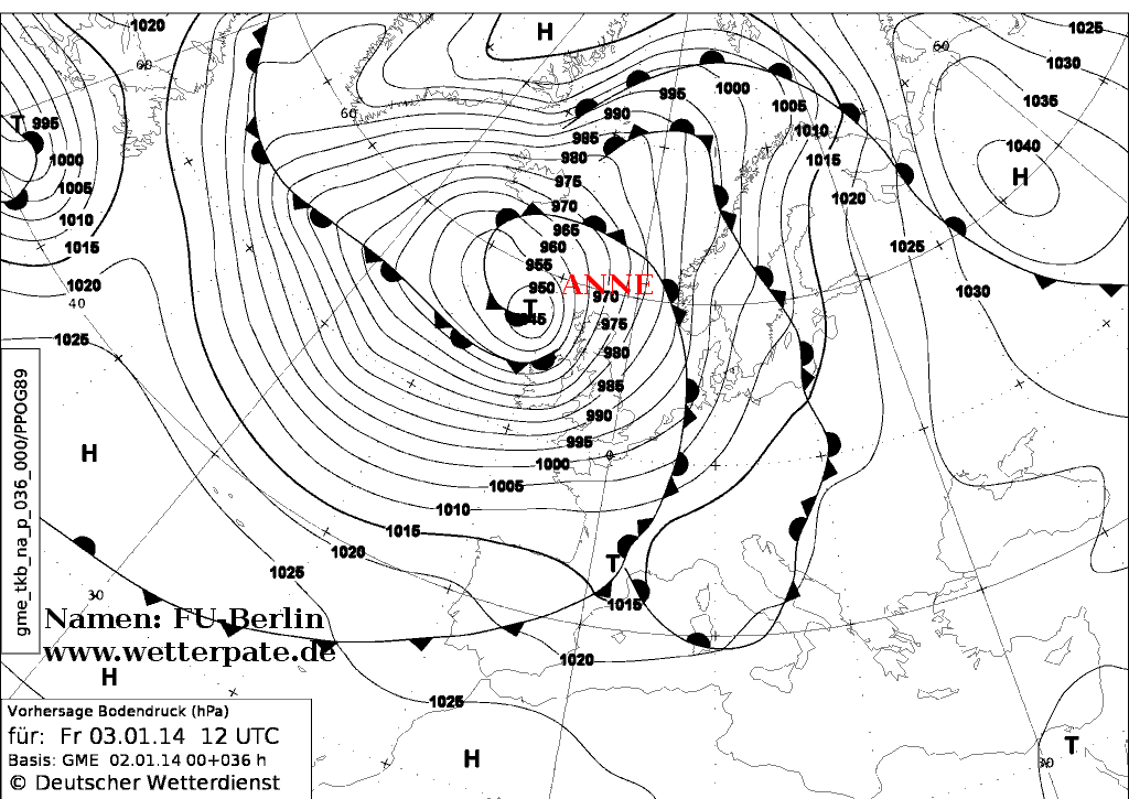
Anne
- Anne – 1–6 January 2014. 945 hPa. [31] Anne was a winter storm that affected western Europe bringing storm surges along the coasts of France and the United Kingdom on high spring tides a month after Cyclone Xaver brought surges during the previous peak tides to northern Europe.
25 January squall line
On 24 January Sedgemoor District Council in Somerset declared a "major incident" in flooded areas as forecasters warned of more rain. [32] Trees were uprooted and structural damaged was caused to buildings by lightning in the Midlands region. [33] There was also a report of a mini-tornado that touched in Sussex and went though Kent before dissipating.
February
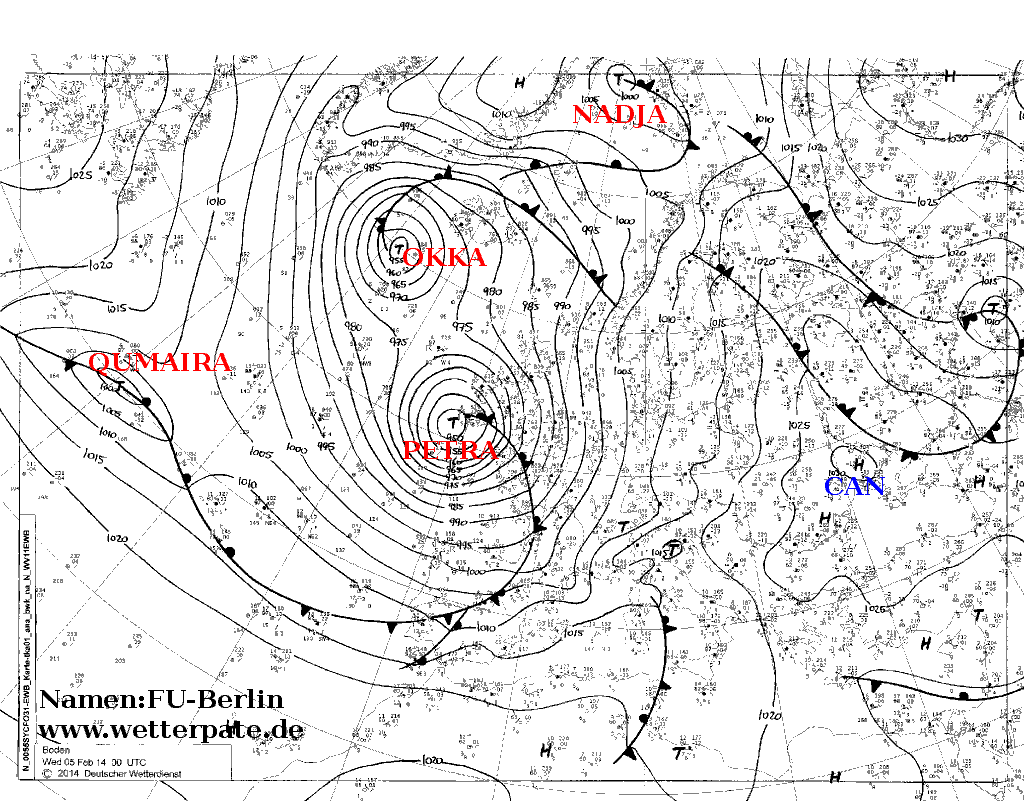
Petra
Petra – 3–8 February 2014. 950 hPa. [34] Another coastal event with high seas washing away the railway line at Dawlish, Devon closing the Exeter to Plymouth line. A wave measuring more than 70 feet was recorded off the coast of Penzance. [35] A buoy close to Penzance triggered a reading of 74.8 feet at 3am, which was reported in some media, [35] [36] this wave height was later removed from the data set as being an anomalous reading, and unlikely to be accurate. [37] [38] 15,000 customers lost power during the storm in southwest England and Wales, [39] 25,000 in Brittany, France [40] and 15,000 lost power across Ireland mainly in the southwest. [41]
A landslip on the West of England Main Line at Crewkerne, Somerset cut off the final link to Exeter on 8 February, [42] expected to take a week to repair, though reports that the track was safe for slow moving trains, however signal problems led to line closure again on 9 February, but was re-opened again that afternoon. The alternative route along the Bristol to Exeter Line was under water on the Somerset Levels,with trains unable to travel between Taunton and Bridgewater. [43] Line at Dawlish out of action, likely to be out of action for sometime and protected by shipping containers. [44]
Ulla
Aftermath
Complex flooding resulting from the storms, coastal flooding, flash flooding, river flooding, groundwater flooding. The total of homes flooded was less than 2007 United Kingdom floods, though conditions more similar to Autumn 2000 western Europe floods
2007 saw 23,479 properties flooded and 3,718 in Yorkshire and the Humber region. [45]
December storm surge (Xaver) saw 688 homes flooded on Yorkshire coast alone. [45]
40 properties flooded in Somerset since December, 800-900 flooded by mid-February, likely to rise. [45] Earlier in January figures of 1000 properties flooded. http://theconversation.com/historical-record-shows-these-floods-are-no-high-water-mark-23266
Coastal flooding
repeated coastal flooding and wave damage to European coasts
Ireland
Galway
Lahinch
Limerick
Cork
Cork City centre was flooded some 3 times... A proposed tidal barrier for Cork ruled out ruled out, as cost-benefit analysis. [46] A proposed tidal barrier for Cork to prevent flooding in the city is ruled out, as a cost-benefit analysis showed that it would be too expensive. [47]
Wales
Aberystwyth from Anne and Christina
SW England
realignment of railway in the southwest away from the coast at Dawlish...
Brittany
Quimper Quimperle In France the Breton town of Morlaix reported flooding. [48]
Northern Spain
Inland flooding
Role of Atmospheric rivers. Main areas of inland flooding: http://earthobservatory.nasa.gov/NaturalHazards/view.php?id=83153
Sussex and Kent
After Cyclone Dirk saturated ground led to localised flooding in southern England, as the storm brought up to 60mm of rain to the UK. A major incident was declared in the region of Leatherhead and Dorking with Fire Brigade unions calling off a planned strike in Surrey and Kent. An Environment Agency spokesman said flooding in Kent and Sussex were the worst to hit the area since Autumn 2000. Yalding Gatwick Airport
Thames Valley
Flooding began Cyclone Dirk had already saturated much of the ground, which led to localised flooding in Southern England, as the storm brought up to 60 mm of rain to parts of the region. A major incident was declared in the valley of the river Mole, around Leatherhead and Dorking, on 24 December, with Fire Brigade unions calling off a planned strike in Surrey and Kent. An Environment Agency spokesman said flooding in Kent and Sussex were the worst to hit the area since Autumn 2000. more flooding n early Janauary in the area
Flooding to west of London following Petra, in February, likely to become worst in 60 years in the area.
some criticism of Jubilee River designed to protect Maidenhead, though blamed for increasing flooding downstream.
Somerset Levels
first flooded at Dirk, and continued through... 2012 Great Britain and Ireland floods which brought severe flooding to the Somerset Levels claims Environment Agency river dredging. claims that the government had not been quick enough to react and provide assistance to flooded *investigate for criticism of Flood and Water Management Act 2010, which put responsibility on reporting flooding on local authorities, for slow response by national government*
River Stour, Dorset
http://www.theguardian.com/environment/2014/jan/06/dorset-residents-waters-recede-damage-flood worst appears to have been early January
Scotland
Dumfries and Galloway, River Kinnel jan 3rd
Ireland
Coastal erosion land stability
high rainfall trigger, rather than cause of sinkholes. sinkhole high wycombe 2 feb http://www.bbc.co.uk/news/uk-england-beds-bucks-herts-26010192 Sinkhole M20, ( Feb) sinkhole Hemel Hempstead 17 homes evacuated (15 Feb) Numerous landslips in south east England, likely to see more in coming months following rainfall. [49]
Avalanche
- investigate alpine avalanche*
Political
vociferous criticism of head of the Environment Agency Chris Smith, Baron Smith of Finsbury by Bridgewater and West Somerset MP Ian Liddell-Grainger In 2014, Liddell-Grainger called Environment Agency chairman Baron Smith of Finsbury a "little git", a "coward" and claimed he would "stick his head down the loo and flush". [50]
Eric Pickles apologised "unreservedly" for not dredging saying that "the goverment made a mistake in listening to the advice of the Environment Agency". [51]
Criticism of flood management by government, with upland clearance grants, better to manage flooding by increasing upland water management strategies.
cost-benefit analyses in decision making. [52]
EU relief
UK central government not access EU Solidarity funds, [53] recieved 127 million from the fund following the 2007 floods. [54] British government declining to apply for EU solidarity fund, ministers reportedly said due to impact on UK rebate
UK government turned down assistance from Netherlands, with concrete offers of material assistance declined. [55]
Flood Context
5,800 homes flooded in England and Wales during the winter (*find estimate number from Xaver tidal surge) the total was 55,300 properties after the 2007 United Kingdom floods, and more than 10,000 following those in Autumn 2000 floods. [56] http://www.bbc.co.uk/blogs/paulhudson/posts/UK-flooding-put-in-context
Climate of W Europe shows natural variation in flood frequency, which can bee seen in long records which stretch back over a century for some locations. [56] from these records the 1890s and 1920s are two examples of flood-rich periods, and over the last 50 years we have moved from the flood poor decades of the 1960-1980s, to the flood rich decades from the late 1990s to the present. [56]
Most monitoring equipment was installed in the 1960s and 1970s, and with only 30-40 years of data it is difficult to estimate the magnitude of extreme events that occur, on average, much less frequently. It’s not surprising then that new records are set in every major incident – the combination of only relatively recent historical data and the fact that each flood tends to affect a different set of places makes this statistically inevitable. Worse still, the usefulness of these already short records is reduced by both changing land use, which alters the way water flows through river catchments and the storage capacity of river channels, and by a changing climate, which alters the location, timing and duration of extreme rainfall events. [56]
This high natural variability in extreme weather events including flooding is probably driven by changes in global atmospheric and ocean circulation patterns, although this is by no means definitively established. [56]
See also
- Met Office and Centre for Ecology & Hydrology Report; The Recent Storms and Floods in the UK, February 2014.
- Flooding France Italy snow Austria Slovenia Serbia
Sort
http://www.thelocal.fr/20140212/video-french-coast-atlantic-erosion-storms http://connexionfrance.com/winter-storms-erosion-coast-aquitaine-france-15457-view-article.html http://connexionfrance.com/oil-beaches-dead-birds-pollution-coast-France-15454-view-article.html http://www.rms.com/blog/2014/01/15/winterstorms/
MeteoFrance
25 February mild temperatures in Europe - http://www.meteofrance.fr/actualites?articleId=4057573 21 Feb winter record rain France - http://www.meteofrance.fr/actualites?articleId=3956857 19 Feb mild start to year in France - http://www.meteofrance.fr/actualites?articleId=3858169 14 Feb rainy winter NW and SE France - http://www.meteofrance.fr/actualites?articleId=3676891 6 Feb why storms France NAO - http://www.meteofrance.fr/actualites?articleId=3355213 3 Feb warm jan France - http://www.meteofrance.fr/actualites?articleId=3043796 17 Jan warm early jan inc 15 nove-15 jan temp graph- http://www.meteofrance.fr/actualites?articleId=2516812 8 Jan warm france http://www.meteofrance.fr/actualites?articleId=2222858 6 Jan christina http://www.meteofrance.fr/actualites?articleId=2099603 Xaver http://www.meteofrance.fr/actualites?articleId=896194 Godehard - http://www.meteofrance.fr/actualites?articleId=415978 http://www.meteofrance.fr/actualites?articleId=408211
http://www.ioc-sealevelmonitoring.org/station.php
Thema des Tages: Ulla macht viel Wind
Das Thema dieses Winters ist - anders als von vielen erhofft - nicht der Schnee, sondern immer wieder der Wind. Und auch der morgige Samstag schickt sich an, erneut sehr windig zu werden. Sturmtief "Ulla", das aktuell zu den Britischen Inseln zieht, hat neben Regen und sehr milden Temperaturen auch einige Sturmböen für Deutschland im Schlepptau. "Ulla" reiht sich damit nahtlos in die Kette von Sturmtiefs ein, die uns seit Oktober des letzten Jahres in schöner Regelmäßigkeit besuchen. Den Anfang nennenswerter Sturmtiefs machte dabei Orkan "Christian" am 28. Oktober 2013, der mit satten 172 km/h in St. Peter-Ording (Schleswig-Holstein) auftrumpfen konnte. Es folgte Orkantief "Xaver" am 5. und 6. Dezember 2013, das vor allem durch eine schwere Sturmflut an der Nordsee auffiel. Am 24. Dezember 2013 war unter Orkantief "Dirk" hauptsächlich der Nordwesten Deutschlands betroffen. Am 3. Januar 2014 machte Orkantief "Anne" mit einer ausgeprägten Gewitterlinie auf sich aufmerksam. Dabei kam es zu Orkanböen bis 126 km/h (Bremerhaven). Am 6. und 7. Februar 2014 machte uns zuletzt Orkantief "Qumaira" das Leben schwer, wobei besonders in Nordrhein-Westfalen und Niedersachsen einige Sturmschäden zu verzeichnen waren. Aktuell dürfen wir uns also mit dem neuen Sturmtief "Ulla" beschäftigen, bei dem der auf Süd drehende Wind ab heute Abend wieder deutlich auffrischt. Gingen die Prognosen der maximalen Windgeschwindigkeiten des Tiefs vor einigen Tagen zum Teil noch von orkanartigen Böen über 103 km/h bis ins Flachland im Nordwesten Deutschland aus, so sieht es aktuell nicht mehr ganz so dramatisch aus. Der stärkste Wind wird nun auf der Nordsee und den Britischen Inseln erwartet. Dort können allerdings durchaus 130 km/h oder mehr erreicht werden, also volle Orkanstärke. Für Deutschland lässt sich eine grobe Einteilung der maximalen Windstärke von Freitagabend bis Sonntagfrüh machen, wobei der Wind geographisch betrachtet ein Gefälle von Südost nach Nordwest aufweist(siehe Grafik zu den maximalen Windböen, zu finden rechts in der Rubrik "Thema des Tages" unter [mehr]). Letztlich können an der Nordsee ganz vereinzelte orkanartige Böen über 103 km/h (Bft 11) vorkommen, Orkanböen (Bft 12) bleiben auf exponierte Gipfellagen beschränkt. Im Nordwesten, etwa von Schleswig-Holstein bis zum Rheinland, sind Böen von 70 bis 90 km/h (Bft 8 bis 10) zu erwarten. Daran anschließend gibt es in einem Streifen von Mecklenburg-Vorpommern bis nach Rheinland-Pfalz und dem Saarland Böen zwischen 60 und 70 km/h (Bft 7 bis 8). Weiter nach Südosten sind es noch 50 bis 65 km/h (Bft 7 bis 8), ganz im Süden wird der Wind kaum noch ein Thema sein. Ursache der zahlreichen aufeinanderfolgenden Sturmtiefs ist eine Großwetterlage, die sich seit Wochen hält. Mit der sogenannten West-Wetterlage können atlantische Tiefs immer wieder bis nach Mittel- bzw. Nordeuropa vordringen und bringen oft starken Wind mit. Ein kräftiges Hoch, das diese Tiefs blockierte, lag meist zu weit im Osten. Durch diese Tiefs war letztlich auch die beständige Zufuhr milder Luft vom relativ warmen Atlantik nach Deutschland garantiert, sodass ganz nebenbei der Winter bei uns kaum Fuß fassen konnte. So scheint es erst einmal auch weiterzugehen... Dipl.-Met. Simon Trippler Deutscher Wetterdienst Vorhersage- und Beratungszentrale Offenbach, den 14.02.2014 Copyright (c) Deutscher Wetterdienst [57]
27 November a strong Foehn wind was reported in eastern Norway from westerly flow. [58]
Christine
974 hPa http://elpais.com/elpais/2014/03/03/actualidad/1393837911_927799.html http://www.lemonde.fr/planete/article/2014/03/03/inondations-dans-le-finistere-en-raison-des-grandes-marees_4376611_3244.html http://connexionfrance.com/france-storm-atlantic-weather-warning-seas-flooding-coast-coastal-woman-died-15516-view-article.html http://www.thelocal.fr/20140303/western-france-on-alert-for-coastal-flooding http://www.ouest-france.fr/inondations-direct-le-littoral-reste-en-vigilance-ce-lundi-1976286 http://www.ouest-france.fr/erdeven-une-randonneuse-decede-emportee-par-une-vague-1973199 warnings red north of Lisbon, orange to south. IPMA http://www.ouest-france.fr/node/1976286 http://www.ouest-france.fr/node/1976523 http://www.ouest-france.fr/node/1976611 http://www.keraunos.org/actualites/fil-infos/2014/mars/orage-vent-violent-3-mars-2014-vendee-mouilleron-le-captif.html?PHPSESSID=vaqnpf865sl9l7r3ckf0om05j3
Unnamed
http://www.met.fu-berlin.de/de/wetter/maps/Prognose_20140307.gif NWS OPC @NWSOPC 5h
- SEVIRI RGB, OPC 12Z #Atlantic sfc analys w/968 hPa #hurricane frc low moving NE & intensifying to 948 hPa at 24H pic.twitter.com/EgpZMoUnhy
https://twitter.com/NWSOPC/status/441966588745375745/photo/1
Jorun (unnamed by FUB)
high pressure builds over UK and western Europe for first time in months, directing Atlantic storm path to north again. [59] designated name Jorun by Norwegian Meteorological Institute on 8 March 2014. http://www.yr.no/nyheter/1.11591592 http://www.met.no/Ekstremv%C3%A6ret+Jorun+kommer.b7C_xdjQ1n.ips Finnmark, northern Norway expecting winds 30-40m/s to coincide with the start of the Finnmarksløpet dog sled race. http://www.nordlys.no/nyheter/article7216299.ece -SMHI- a deep low pressure passes today over northern Scandinavia and makes it proper windy, especially to Norrland... Ett djupt lågtryck passerar i dag över nordligaste Skandinavien och ger riktigt blåsigt i framför allt Norrland, på kalfjället i norra Lappland väntas de västliga vindarna nå stormstyrka. Å andra sidan har vi nu blivit av med det gråa molntäcke som dominerat vädret den senaste tiden; solen skiner på många håll, särskilt i södra halvan av landet och det är mycket milt för årstiden. I går hade vi säsongshögsta i Oskarshamn med 12,7 grader, och under söndagen tycks det finnas utsikter att slå den noteringen. Stormen i nordligaste fjällen upphör i kväll, men även i morgon blir det en smula blåsigt där med byar av snö eller regn. Vindarna har då allmänt vridit till sydväst över landet.
Danli
946hPa https://twitter.com/NWSOPC/status/442324783338754048/photo/1 unlikely to impact land
| Country | Location | Speed |
|---|---|---|
| Germany
|
Heligoland | 193 kilometres per hour (120 mph) |
| Hörnum | 183 kilometres per hour (114 mph) | |
| Belgium
|
Zeebrugge | 119 kilometres per hour (74 mph) |
| Denmark
|
Kegnæs, near Sønderborg | 193 kilometres per hour (120 mph) |
| Sandnæs Hage, near Viborg | 180 kilometres per hour (110 mph) | |
| Estonia
|
108 kilometres per hour (67 mph) | |
| United Kingdom
|
Southern English coast | 140 kilometres per hour (87 mph) |
| France
|
Cap Gris-Nez ( Pas-de-Calais) | 147 kilometres per hour (91 mph) |
| Camaret-sur-Mer ( Finistère) | 134 kilometres per hour (83 mph) | |
| Boulogne-sur-Mer ( Pas-de-Calais) | 126 kilometres per hour (78 mph) | |
| Cap de la Hague ( Manche) | 125 kilometres per hour (78 mph) | |
| Ouessant ( Finistère) | 116 kilometres per hour (72 mph) | |
| Île de Groix ( Morbihan) | 115 kilometres per hour (71 mph) | |
| Pointe du Raz ( Finistère) | 112 kilometres per hour (70 mph) | |
| Netherlands
|
183 kilometres per hour (114 mph) |
References
- ^ Spencer, Thomas; Brooks, Susan M.; Evans, Ben R.; Tempest, James A.; Möller, Iris (July 2015). "Southern North Sea storm surge event of 5 December 2013: Water levels, waves and coastal impacts". Earth-Science Reviews. 146: 120–145. doi: 10.1016/j.earscirev.2015.04.002. Retrieved 26 February 2016.
- ^ Sulieman, Cara (5 January 2014). "Nineteen flood warnings issued as storm surge hits east coast". STV News. Retrieved 2 January 2014.
- ^ "Banff Community Centre evacuated due to flooding". Aberdeenshire Council. 5 December 2013. Retrieved 2 January 2014.
- ^ "04 December 2013 Severe storm surge warning". Management Unit of the North Sea Mathematical Models. 4 December 2013. Retrieved 15 December 2013.
- ^ "Resorts need £1m repairs for damage caused by tidal surge". Yorkshire Post. 11 December 2013. Retrieved 20 December 2013.
- ^ "Flooded Spurn Point 'island' leaves RNLI lifeboat crew 'living on a ship' in wake of North Sea tidal surge". Hull Daily Mail. 20 December 2013. Retrieved 20 December 2013.
- ^ Batson, Richard (12 December 2013). "Sea surge damage in north Norfolk tops £1m says council chief as he opens talks with government to get financial help". Eastern Daily Press. Retrieved 20 December 2013.
- ^ Mills, Ian; Remko Scharroo; Luciana Fenoglio (December 2013). "Xaver affected much of northern Europe on 5 and 6 December and caused worst storm surge for decades in the North Sea". EUMETSAT. Retrieved 14 December 2013.
- ^ "CryoSat Tracks Storm Surge". Space Daily. 12 December 2013. Retrieved 12 December 2013.
- ^ Kitching, Laura (6 December 2013). "Strong winds, rough seas and a storm surge". Practical Boat Owner. Retrieved 12 December 2013.
- ^ a b c "Tempêtes de Noël et du jour de l'An : le point ce samedi". La Chaîne Météo. 21 December 2013. Retrieved 27 March 2014.
- ^ Chamley, Hervé. Geosciences, Environment and Man. p. 135.
- ^ a b "Huit départements en vigilance orange vagues-submersion". Le Monde (in French). 6 January 2014. Retrieved 12 January 2014.
- ^ Ó Caollaí, Éanna (6 January 2014). "Flooding in several areas as severe storm hits country". The Irish Times. Retrieved 6 January 2014.
- ^ "Update on weather damage in Cornwall". Cornwall Council. 9 January 2014. Retrieved 10 January 2014.
- ^ "Highways teams focus on flood clean-up". Devon County Council. 8 January 2014. Retrieved 11 January 2014.
- ^ "National Monuments Service to rebury century-old shipwreck unearthed by Storm Christine". Irish Independent. 10 January 2014. Retrieved 11 January 2014.
- ^ a b c Gittens, Geraldine; Ralph Riegel; Caroline Crawford (6 January 2014). "Downpours and gale force winds batter the country". Irish Independent. Retrieved 11 January 2014.
- ^ Kelly, Louise (9 January 2014). "House falling off cliff following Superstorm Christine". Irish Independent. Retrieved 11 January 2014.
- ^ Siggins, Lorna (8 January 2014). "Many lighthouses damaged in storm but still in operation". The Irish Times. Retrieved 11 January 2014.
- ^ "Tempête. Direct : les cours d'eau bretons toujours sous vigilance orange". Le Telegramme (in French). 7 January 2014. Retrieved 12 January 2014.
- ^ "Inondations à Pontivy. Une digue géante gonflable pour protéger une rue". Ouest France (in French). 5 January 2014. Retrieved 12 January 2014.
- ^ "Europe's coastline hit by more giant waves". Euronews. 7 January 2014. Retrieved 11 January 2014.
- ^ "America froze, wrecking ball waves slam Europe". Euronews. 10 January 2014. Retrieved 11 January 2014.
- ^ "Giant wave in Foz do Porto". Euronews. 7 January 2014. Retrieved 11 January 2014.
- ^ "Vagues destructrices au Maroc". Meteo Paris (in French). 9 January 2014. Retrieved 12 January 2014.
- ^ "Houle dangerouse: Nuit agitee, vagues geantes et alerte sur lel littoral atlantique marocain". Medias 24. 7 January 2014. Retrieved 12 January 2014.
- ^ Rao, Nathan (18 December 2013). "Hold on to your hats! 100 mph Storm Emily will roar in tonight with 'a sting in her tail'". Daily Express. Retrieved 9 February 2014.
- ^ "Christmas will be a washout as storms continue". AOL Travel. 19 December 2013. Retrieved 19 December 2013.
- ^ "19 December 2013 surface analysis". Met Office. Retrieved 26 December 2013.
- ^ "3 January 2014 surface analysis". Free University Berlin. Retrieved 6 January 2014.
- ^ "Somerset floods: 'Major incident' declared". BBC News. BBC. 24 January 2014. Retrieved 24 January 2014.
- ^ "West Bromwich church and houses hit by lightning in storm". BBC News. BBC. 25 January 2014. Retrieved 25 January 2014.
- ^ "5 February 2014 surface analysis". Free University Berlin. Retrieved 5 February 2014.
- ^ a b "Dawlish railway line damage may leave Devon and Cornwall rail links out of action for months". Western Morning News. 6 February 2014. Retrieved 10 February 2014.
- ^ Rao, Nathan (6 February 2014). "Monster 75 foot wave smashes into BRITISH coast: Atlantic superstorm to hit UK TOMORROW". Daily Express. Retrieved 11 February 2014.
- ^ Ferrell, Jesse (7 February 2014). "Big Waves in United Kingdom, but no 75-Footer". Accuweather. Retrieved 11 February 2014.
- ^ "Who, What, Why: How do you measure a wave?". BBC News. 6 February 2014. Retrieved 11 February 2014.
- ^ "Power cut hits 15,000 households in south-west England". BBC News. 4 February 2014. Retrieved 11 February 2014.
- ^ "25 000 foyers privés d'électricité en Bretagne après le passage de Petra". Le Monde (in French). 5 February 2014. Retrieved 11 February 2014.
- ^ "15,000 without power amid further flooding". RTE News. 5 February 2014. Retrieved 11 February 2014.
- ^ "Landslip causes further rail misery for South West travellers". BBC News. 8 February 2014. Retrieved 9 February 2014.
- ^ "Taunton to Bridgwater railway line remains under water". BBC News. Retrieved 9 February 2014.
- ^ "Shipping containers provide flood defence at Dawlish". ITV News. 9 February 2014. Retrieved 9 February 2014.
- ^ a b c Hudson, Paul (10 February 2014). "UK flooding put in context". BBC Blog: Weather Paul Hudson. Retrieved 16 February 2014.
- ^ Roche, Barry (10 February 2014). "Experts rule out tidal barrier as fix for Cork city flood problems". The Irish Times. Retrieved 10 February 2014.
- ^ Roche, Barry (10 February 2014). "Experts rule out tidal barrier as fix for Cork city flood problems". The Irish Times. Retrieved 10 February 2014.
- ^ "Russian sailor swept overboard, power cuts, as Storm Dirk hits north-west France". RFI. 24 December 2013. Retrieved 24 December 2013.
- ^ Petley, Dave (11 February 2014). "Southern England: the potential for movement in deep-seated landslides". AGU Blogosphere: The Landslide Blog. Retrieved 15 February 2014.
- ^ "'I'd like to stick his head down the loo and flush': MP's fury at Environment Agency boss Chris Smith on visit to flooded Somerset". London Evening Standard. 7 February 2014. Retrieved 9 Feb 2014.
- ^ "UK floods: Government 'made a mistake' by not dredging". BBC News. 9 February 2014. Retrieved 9 February 2014.
- ^ Russell, Vivienne (10 February 2014). "Treasury rules restricted flood defence action, Environment Agency says". Public Finance. Retrieved 10 February 2014.
- ^ "EU wonders why Britain hasn't tapped fund for flood relief". Reuters via Chicago Times. 12 February 2014. Retrieved 15 February 2014.
- ^ Pickard, Jim (13 February 2014). "UK looks at asking Brussels for flood aid". Financial Times. Retrieved 15 February 2014.
- ^ "Floods: British government turned down Dutch help". Channel 4 News. 14 February 2014. Retrieved 15 February 2014.
- ^ a b c d e Bates, Paul; Penny Johnes; Richard Pancost; Thorsten Wagener (24 February 2014). "Climate change and natural patterns combined to bring wettest winter ever". The Conversation. Retrieved 6 March 2014.
-
^ Tripper, Simon (14 February 2014). "Thema des Tages 14/02/2014: Ulla macht viel Wind". Deutsche Wetterdienst (in German).
{{ cite news}}:|access-date=requires|url=( help) - ^ "November 2013 - Orkankatastrof i Filippinerna". SMHI (in Swedish). 20 December 2013. Retrieved 17 February 2014.
- ^ Schafernaker, Tomasz (7 March 2014). "High times for the UK". BBC Weather. Retrieved 8 March 2014.
- ^
a
b
c
d
e
"Bilan de la tempête Christian" (in French).
{{
cite web}}
: Text "consulté le 28 octobre 2013" ignored ( help) -
^
"Flash du 28 octobre : la tempête Christian" (in French).
{{
cite web}}
: Unknown parameter|consulté le=ignored (|access-date=suggested) ( help); Unknown parameter|site=ignored ( help) -
^ Cite error: The named reference
estoniewas invoked but never defined (see the help page). -
^
"Suivie de la tempête Christian" (in French).
{{
cite web}}
: Unknown parameter|consulté le=ignored (|access-date=suggested) ( help); Unknown parameter|site=ignored ( help)