
Mediterranean tropical cyclones, sometimes referred to as Mediterranean hurricanes or Medicanes, are rare meteorological phenomena observed in the Mediterranean Sea. Due to the dry nature of the Mediterranean region, the formation of tropical and subtropical cyclones is infrequent, with only 126 recorded tropical or subtropical cyclones between 1947 and 2020. [1] [2] Four of the "Medicanes" that formed between 1982 and 2006 were of Category 1 hurricane strength on the Saffir–Simpson scale. [3] [4] One storm was recorded reaching Category 2 intensity. [5] No agency, however, is officially responsible for monitoring the formation and development of Medicanes. Tropical cyclogenesis typically occurs within two separate regions of the sea. The first region, encompassing areas of the western Mediterranean, is more conducive for development than the other, the Ionian Sea to the east. On very rare occasions though, a tropical or subtropical cyclone may develop within the Black Sea. [6] [7] The rough mountainous geography of the region raises additional difficulties despite being favorable for the development of severe weather and convective activity in general, and only with abnormal meteorological circumstances can Medicanes form. Numerous studies have been conducted on the impact of global warming on Mediterranean tropical cyclone formation, generally concluding that fewer yet more intense storms would form.
The development of tropical or subtropical cyclones in the Mediterranean Sea can usually only occur under somewhat unusual circumstances. Low wind shear and atmospheric instability induced by incursions of cold air are often required. A majority of Medicanes are also accompanied by upper-level troughs, providing energy required for intensifying atmospheric convection—thunderstorms—and heavy precipitation. The broaclinic properties of the Mediterranean region, with high temperature gradients, also provides necessary instability for the formation of tropical cyclones. Another factor, rising cool air, provides necessary moisture as well. Warm sea surface temperatures (SSTs) are mostly unnecessary, however, as most Medicanes' energy are derived from warmer air temperatures. When these favorable circumstances coincide, the genesis of warm-core Mediterranean tropical cyclones, often from within existing cut-off cold-core lows, is possible in a conducive environment for formation.
Several notable and damaging Medicanes are known to have occurred. In September 1969, a North African Mediterranean tropical cyclone produced flooding that killed nearly 600 individuals, left 250,000 homeless, and crippled local economies. A Medicane in September 1996 that developed in the Balearic Islands region spawned six tornadoes, and inundated parts of the islands. Several Medicanes have also been subject to extensive study, such as those of January 1982, January 1995, September 2006, and November 2011. The January 1995 storm is one of the best-studied Mediterranean tropical cyclones, with its close resemblance to tropical cyclones elsewhere and availability of observations. The Medicane of September 2006, meanwhile, is well-studied, due to the availability of existing observations and data. In November 2011, the NOAA's Satellite Analysis Branch monitored a Medicane, named Rolf by the Free University of Berlin (FU Berlin), though it ceased doing so the following month. However, in 2015, the NOAA resumed issuing advisories for tropical systems in the Mediterranean region. No agency is officially responsible for monitoring the basin. If a "hurricane season" were ever to be demarcated in the Mediterranean, it would extend from August to May during the next year, based upon occurrences so far. However, the formation of Medicanes is possible during any time of the year, with activity peaking in the months between September and January. [2] [8]
Meteorological classification and history
Historically, the term tropical-like cyclone was coined in the 1980s to unofficially distinguish tropical cyclones developing outside the tropics (like in the Mediterranean Basin) from those developing inside the tropics. The term tropical-like was in no way meant to indicate a hybrid cyclone exhibiting characteristics not usually seen in "true" tropical cyclones. [9] In their matured stages, Mediterranean tropical cyclones show no difference to other tropical cyclones. [10] And only tropical cyclones are known to develop into hurricanes. [11] Mediterranean hurricanes or medicanes are therefore not different from hurricanes elsewhere.
Mediterranean tropical cyclones are not considered to be formally classified tropical cyclones and their region of formation is not officially monitored by any agency with meteorological tasks. [12] However, the NOAA subsidiary Satellite Analysis Branch released information related to a medicane in November 2011 while it was active, it ceased doing so on 16 December 2011. [13] In 2015, the NOAA resumed services in the Mediterranean region, [14] and by 2016, the NOAA was issuing advisories on a new tropical system, Tropical Storm 90M. [15] Additionally, beginning in October 2017, the newly-formed European Medicane Monitoring Center (EMMC) issues unofficial advisories on "Medicanes" in the region. [16] [17] ESTOFEX is issuing bulletins since 2005 that can include tropical-like cyclones, among others. No agency with meteorological tasks, however, is officially responsible for monitoring the formation and development of Medicanes as well as for their naming.
Despite all this, the whole Mediterranean Sea lies within the Greek area of responsibility with the Hellenic National Meteorological Service (HNMS) as the governing agency, [18] while France's Météo-France National serves as a "preparation service" for the western part of the Mediterranean as well. [19] As the only official agency covering the whole Mediterranean Sea, HNMS publications are of particular interest for the classification of Medicanes. HNMS calls the meteorological phenomenon Mediterranean tropical-like Hurricane in its annual bulletin and – by also using the respective portmanteau word Medicane– makes the term Medicane quasi-official. [20] In a joint article with the Laboratory of Climatology and Atmospheric Environment of the University of Athens, the Hellenic National Meteorological Service outlines conditions to consider a cyclone over the Mediterranean Sea a Medicane:
The criteria applied in order to identify medicanes concern the detailed structure, the size and the lifetime of the systems using Meteosat satellite images in the infrared channel. They must have a continuous cloud cover and symmetric shape around a clearly visible cyclone eye. [2]
In the same article, a survey of 37 Medicanes revealed that Medicanes could have a well-defined cyclone eye at estimated maximum sustained winds between 47 kilometres per hour (29 mph) and 180 kilometres per hour (110 mph), with the lower end being exceptionally low for warm core cyclones. [2] Medicanes can indeed develop well-defined eyes at such low maximum sustained winds of around 30 miles per hour (48 km/h) as could be seen for a 22 October 2015 Medicane near the Albanian coast. [21] This is much lower than the lower threshold for eye development in tropical systems in the Atlantic Ocean which seems to be close to 50 miles per hour (80 km/h), well below hurricane-force winds. [22]
Several notable and damaging Medicanes are known to have occurred. In September 1969, a North African Mediterranean tropical cyclone produced flooding that killed nearly 600 individuals, left 250,000 homeless, and crippled local economies. A Medicane in September 1996 that developed in the Balearic Islands region spawned six tornadoes, and inundated parts of the islands. Several Medicanes have also been subject to extensive study, such as those of January 1982, January 1995, September 2006, November 2011, and November 2014. The January 1995 storm is one of the best-studied Mediterranean tropical cyclones, with its close resemblance to tropical cyclones elsewhere and availability of observations. The Medicane of September 2006, meanwhile, is well-studied, due to the availability of existing observations and data.
Given the low profile of HNMS in forecasting and classifying tropical-like systems in the Mediterranean, a proper classification system for Mediterranean tropical-like cyclones does not exist. The HNMS criterion of a cyclonic eye for considering a system a Medicane [2] is usually valid for a system at peak strength, often only hours before landfall, which is not suitable at least for forecasts and warnings.
Unofficially, Deutscher Wetterdienst (DWD, the German meteorological service) proposed a system to forecast and classify tropical-like cyclones based on the NHC classification for the northern Atlantic Ocean. [23] To account for the broader wind field and the larger radius of maximum winds of tropical-like systems in the Mediterranean (see the section Development and characteristics below), DWD is suggesting a lower threshold of 112 km/h for the use of the term Medicane in the Mediterranean instead of 119 km/h as suggested by the Saffir-Simpson scale for Atlantic hurricanes. [23] The DWD proposal and also US-based forecasts (NHC, NOAA, NRL etc.) use one-minute sustained winds while European-based forecasts use ten-minute sustained winds which makes a difference of roughly 14% in measurements. [24] The distinction is also of direct practical use (for example for a comparison of NOAA bulletins with EUMETSAT, ESTOFEX and HNMS bulletins). To account for the difference, the DWD proposal is shown below for both one-minute and deduced ten-minute sustained winds (see tropical cyclone scales for conversions):
| maximum sustained winds | Mediterranean Tropical Depression | Mediterranean Tropical Storm | Medicane |
|---|---|---|---|
| 1-minute average | ≤62 km/h (≤17 m/s; ≤38 mph; ≤33 knots) | 63–111 km/h (18–30 m/s; 39–69 mph; 34–60 knots) | ≥112 km/h (≥31 m/s; ≥70 mph; ≥61 knots) |
| 10-minute average | ≤54 km/h (≤14 m/s; ≤33 mph; ≤29 knots) | 56–98 km/h (15–27 m/s; 35–61 mph; 30–53 knots) | ≥99 km/h (≥28 m/s; ≥62 mph; ≥54 knots) |
Another proposal uses roughly the same scale but suggests to use the term Medicane for tropical storm force cyclones and Major Medicane for hurricane force cyclones. [21] Both proposals would fit the observation, that half of the 37 cyclones surveyed by HNMS with a clearly observable hurricane-like eye, as the major criterion for assigning the medicane status, showed maximum sustained winds between 76–110 kilometres per hour (41–59 kn), while another quarter of the medicanes peaked at lower wind speeds. [2]
Climatology

Mediterranean tropical cyclones are not considered to be formally classified tropical cyclones and their region of formation is officially monitored by any agency, [12] and though the Satellite Analysis Branch released information related to a medicane in November 2011 while it was active, it ceased doing so on December 16, 2011. [13] However, in 2015, the NOAA resumed services in the Mediterranean region, [14] and by 2016, the NOAA was issuing advisories on a new tropical system, Tropical Storm 90M. [15] Despite this, the Mediterranean Sea lies within the Greek area of responsibility, [25] while France's Météo-France National serves as a "preparation service" for the areas as well. [26] Additionally, beginning in October 2017, the newly-formed European Medicane Monitoring Center (EMMC) issues unofficial advisories on "Medicanes" in the region. [16] [17] A majority of Mediterranean tropical cyclones form over two separate regions. The first, more conducive for development than the other, encompasses an area of the western Mediterranean bordered by the Balearic Islands, southern France, and the shorelines of the islands of Corsica and Sardinia. The second identified region of development, in the Ionian Sea between Sicily and Greece and stretching south to Libya, is less favorable for tropical cyclogenesis. An additional two regions, in the Aegean and Adriatic seas, produce fewer Medicanes, while activity is minimal in the Levantine region. The geographical distribution of Mediterranean tropical cyclones is markedly different from that of other cyclones, with the formation of regular cyclones centering on the Pyrenees and Atlas mountain ranges, the Gulf of Genoa, and the island of Cyprus in the Ionian Sea. [27] Although meteorological factors are most advantageous in the Adriatic and Aegean seas, the closed nature of the region's geography, bordered by land, allows little time for further evolution. [28]
The geography of mountain ranges bordering the Mediterranean are conducive for severe weather and thunderstorms, with the sloped nature of mountainous regions permitting the development of convective activity. [29] Although the geography of the Mediterranean region, as well as its dry air, typically prevent the formation of tropical cyclones, when certain meteorological circumstances arise, difficulties influenced by the region's geography are overcome. [30] The occurrence of tropical cyclones in the Mediterranean Sea is generally extremely rare, with an average of 1.57 forming annually and merely 99 recorded occurrences of tropical-like storms discovered between 1948 and 2011 in a modern study, with no definitive trend in activity in that period. [31] Few medicanes form during the summer season, though activity typically rises in autumn, peaks in January, and gradually decreases from February to May. [27] In the western Mediterranean region of development, approximately 0.75 such systems form each year, compared to 0.32 in the Ionian Sea region. [32]
Studies have evaluated that global warming can result in higher observed intensities of tropical cyclones as a result of deviations in the surface energy flux and atmospheric composition, which both heavily influence the development of medicanes as well. In tropical and subtropical areas, sea surface temperatures (SSTs) rose 0.2 °C (32.4 °F) within a 50-year period, and in the North Atlantic and Northwestern Pacific tropical cyclone basins, the potential destructiveness and energy of storms nearly doubled within the same duration, evidencing a clear correlation between global warming and tropical cyclone intensities. [33] Within a similarly recent 20-year period, [34] SSTs in the Mediterranean Sea increased by 0.6 to 1 °C (33.1 to 33.8 °F), [33] though no observable increase in medicane activity has been noted, as of August 2013. [31] In 2006, a computer-driven atmospheric model evaluated the future frequency of Mediterranean cyclones between 2071 and 2100, projecting a decrease in autumn, winter, and spring cyclonic activity coinciding with a dramatic increase in formation near Cyprus, with both scenarios attributed to elevated temperatures as a result of global warming. [35] In another study, researchers found that more tropical-like storms in the Mediterranean could reach Category 1 strength by the end of the 21st Century, with most of the stronger storms appearing in the autumn, though the models indicated that some storms could potentially reach Category 2 intensity. [36] Other studies, however, have been inconclusive, forecasting both increases and decreases in duration, number, and intensity. [37] A third study, conducted in 2013, evaluated that while Medicane activity would likely decline between 10 and 40 percent by 2100, a higher percentage of those that formed would be of greater strength. [38]
Development and characteristics


Factors required for the formation of Medicanes are somewhat different from those normally expected of tropical cyclones; known to emerge over regions with sea surface temperatures (SSTs) below 26 °C (79 °F), Mediterranean tropical cyclones often require incursions of colder air to induce atmospheric instability. [27] A majority of medicanes develop above regions of the Mediterranean with SSTs of 15 to 26 °C (59 to 79 °F), with the upper bound only found in the southernmost reaches of the sea. Despite the low sea surface temperatures, the instability incited by cold atmospheric air within a baroclinic zone—regions with high differences in temperature and pressure—permits the formation of medicanes, in contrast to tropical areas lacking high baroclinity, where raised SSTs are needed. [39] While significant deviations in air temperature have been noted around the time of Mediterranean tropical cyclones' formation, few anomalies in sea surface temperature coincide with their development, indicating that the formation of medicanes is primarily controlled by higher air temperatures, not by anomalous SSTs. [40] Similar to tropical cyclones, minimal wind shear—difference in wind speed and direction over a region—as well as abundant moisture and vorticity encourages the genesis of tropical cyclone-like systems in the Mediterranean Sea. [41]
Due to the confined character of the Mediterranean and the limited capability of heat fluxes—in the case of medicanes, air—sea heat transfer—tropical cyclones with a diameter larger than 300 km (190 mi) cannot exist within the Mediterranean. [42] Despite being a relatively baroclinic area with high temperature gradients, the primary energy source utilized by Mediterranean tropical cyclones is derived from underlying heat sources generated by the presence of convection—thunderstorm activity—in a humid environment, similar to tropical cyclones elsewhere outside the Mediterranean Sea. [43] In comparison to other tropical cyclone basins, the Mediterranean Sea is generally presents a difficult environment for development; although the potential energy necessary for development is not abnormally large, its atmosphere is characterized by its lack of moisture, impeding potential formation. The full development of a medicane often necessitates the formation of a large-scale baroclinic disturbance, transitioning late in its life cycle into a tropical cyclone-like system, nearly always under the influence of a deep, cut-off, cold-core low within the middle-to-upper troposphere, frequently resulting from abnormalities in a wide-spreading Rossby wave—massive meanders of upper-atmospheric winds. [44]

The development of Medicanes often results from the vertical shift of air in the troposphere as well, resulting in a decrease in its temperature coinciding with an increase in relative humidity, creating an environment more conducive for tropical cyclone formation. This, in turn, leads to in an increase in potential energy, producing heat-induced air-sea instability. Moist air prevents the occurrence of convective downdrafts—the vertically downward movement of air—which often hinder the inception of tropical cyclones, [44] and in such a scenario, wind shear remains minimal; overall, cold-core cut-off lows serve well for the later formation of compact surface flux-influenced warm-core lows such as Medicanes. The regular genesis of cold-core upper-level lows and the infrequency of Mediterranean tropical cyclones, however, indicate that additional unusual circumstances are involved the emergence of the latter. Elevated sea surface temperatures, contrasting with cold atmospheric air, encourage atmospheric instability, especially within the troposphere. [39]
In general, most Medicanes maintain a radius of 70 to 200 km (40 to 120 mi), last between 12 hours and 5 days, travel between 700 to 3,000 km (430 to 1,860 mi), develop an eye for less than 72 hours, and feature wind speeds of up to 144 km/h (89 mph); [45] in addition, a majority are characterized on satellite imagery as asymmetric systems with a distinct round eye encircled by atmospheric convection. [42] Weak rotation, similar to that in most tropical cyclones, is usually noted in a Medicane's early stages, increasing with intensity; [46] Medicanes, however, often have less time to intensify, remaining weaker than most North Atlantic hurricanes and only persisting for the duration of a few days. [47] The theoretical maximum potential intensity of Medicanes is equivalent to the lowest classification on the Saffir–Simpson hurricane wind scale, a Category 1 hurricane. While the entire lifetime of a cyclone may encompass several days, most will only retain tropical characteristics for less than 24 hours. [48] Circumstances sometimes permit the formation of smaller-scale Medicanes, although the required conditions differ even from those needed by other Medicanes. The development of abnormally small tropical cyclones in the Mediterranean usually requires upper-level atmospheric cyclones inducing cyclogenesis in the lower atmosphere, leading to the formation of warm-core lows, encouraged by favorable moisture, heat, and other environmental circumstances. [49]
Mediterranean cyclones have been compared to polar lows—cyclonic storms which typically develop in the far regions of the Northern and Southern Hemispheres—for their similarly small size and heat-related instability; however, while Medicanes nearly always feature warm-core lows, polar lows are primarily cold-core. The prolonged life of Medicanes and similarity to polar lows is caused primarily by origins as synoptic-scale surface lows and heat-related instability. [29] Heavy precipitation and convection within a developing Mediterranean tropical cyclone are usually incited by the approach of an upper-level trough—an elongated area of low air pressures—bringing downstream cold air, encircling an existing low-pressure system. After this occurs, however, a considerable reduction in rainfall rates occurs despite further organization, [50] coinciding with a decrease in previously high lightning activity as well. [51] Although troughs will often accompany Medicanes along their track, separation eventually occurs, usually in the later part of a Mediterranean tropical cyclone's life cycle. [50] At the same time, moist air, saturated and cooled while rising into the atmosphere, then encounters the Medicane, permitting further development and evolution into a tropical cyclone. Many of these characteristics are also evident in polar lows, except for the warm-core characteristic. [10]
Known/Documented Occurrences


Numerous other Mediterranean cyclones have occurred, but few as better-documented as those in 1969, 1982, 1995, 1996, 2006, 2011, 2014, 2016, 2017, 2018, and 2020. On 27 September 1983, a Medicane was observed at sea between Tunisia and Sicily, looping around Sardinia and Corsica, coming ashore twice on the islands, before making landfall at Tunis early on 2 October and dissipating. The development of the system was not encouraged by baroclinic instability; rather, convection was incited by abnormally high sea surface temperatures (SSTs) at the time of its formation. It also featured a definitive eye, tall cumulonimbus clouds, intense sustained winds, and a warm core. For most of its duration, it maintained a diameter of 200 to 300 km (120 to 190 mi), though it shrank just before landfall on Ajaccio to a diameter of 100 km (62 mi). Four other notable cyclones occurred in the late twentieth century, on 26 March 1983, 29–30 December 1984, 30–31 October 1997, and 5–8 December 1997, all exhibiting characteristics closely resembling tropical cyclones elsewhere. [52]
Meteorological literature documents a total of 126 "Mediterranean Hurricanes" (or "Medicanes") that have occurred between 1947 and 2020. These systems have occurred in: September 1947, September 1969, September 1973, August 1976, January 1982, September 1983, December 1984, December 1985, January 1991, October 1994, January 1995, September 1996, twice in October 1996, September 1997, March 1999, twice in September 2003, October 2003, August 2005, September 2005, twice in October 2005, December 2005, August 2006, twice in September 2006, March 2007, twice in October 2007, June 2008, August 2008, September 2008, December 2008, January 2009, May 2009 [53], twice in September 2009, October 2009, January 2010, October 2010, November 2010, November 2011, twice in February 2012, once in March 2012, April 2012, October 2012, November 2012, November 2013, January 2014, November 2014, December 2014, October 2015, October 2016, October 2017, November 2017, and September 2018. Additional storms occurred in October 2019 ("Scott"), [54] [55] November 2019 ("Trudy"/"Detlef"), [56] [57] January 2020, [58] September 2020 (Ianos), November 2020 ("David"), and December 2020 ("Elaina"). However, 4 storms formed over the Black Sea: in February 2002, August 2002, September 2005, and in January 2012. [59] [60] [61] [62] [63] [64] [65] [66] [67] [68] [69] [70] [71] [72] [73] [6] [74] [7]
A study performed in 2013 revealed several additional storms, and additional information on Medicanes that formed on April 7, 1984, December 14, 1985, December 5, 1991, January 15, 1995, December 10, 1996, January 26, 1998, March 19, 1999, and May 27, 2003. [75] A second study, conducted in 2007, revealed that additional storms formed on October 18, 2003, October 27, 2005, and December 15, 2005. [76] A third study revealed several more tropical cyclones, of which developed on September 13, 1999, September 10, 2000, October 9, 2000, September 19, 2004, November 3, 2004, October 26 and 17, 2007, December 4, 2008, and April 13, 2012. [48]
1960s
September 23–30, 1969
| Tropical storm (SSHWS) | |
 | |
| Duration | September 23, 1969 – September 30, 1969 |
|---|---|
| Peak intensity | 60 mph (95 km/h) (1-min); Unknown mbar ( hPa) |
An unusually severe Mediterranean tropical cyclone developed on 23 September 1969, southeast of Malta, producing severe flooding. [52] Steep pressure and temperature gradients above the Atlas mountain range were evident on 19 September, a result of cool sea air attempting to penetrate inland; south of the mountains, a lee depression—a low-pressure area in a mountainous region—developed. Under the influence of mountainous terrain, the low initially meandered northeastward. Following the entry of cool sea air, however, it recurved to the southeast before transitioning into a Saharan depression associated with a distinct cold front by 22 September. Along the front's path, desert air moved northward while cold air drifted in the opposite direction, and in northern Libya, warm arid air clashed with the cooler levant of the Mediterranean. The organization of the disturbance improved slightly further before emerging into the Mediterranean Sea on 23 September, upon which the system experienced immediate cyclogenesis, [77] rapidly intensifying while southeast of Malta as a cold-core cut-off low, [78] and acquiring tropical characteristics. [52] In western Africa, meanwhile, several disturbances converged toward Mauritania and Algeria, while the medicane recurved southwestward back toward the coast, losing its closed circulation and later dissipating. [78]
The cyclone produced severe flooding throughout regions of northern Africa. Malta received upward of 123 mm (4.8 in) of rainfall on 23 September, Sfax measured 45 mm (1.8 in) on 24 September, Tizi Ouzou collected 55 mm (2.2 in) on 25 September, Gafsa received 79 mm (3.1 in) and Istanbul measured 46 mm (1.8 in) on 26 September, Cap Bengut collected 43 mm (1.7 in) on 27 September, and Biskra received 122 mm (4.8 in) on 28 September. [79] In Malta, a 20000-ton tanker struck a reef and split in two, while in Gafsa, Tunisia, the cyclone flooded phosphate mines, leaving over 25,000 miners unemployed and costing the government over £2 million per week. Thousands of camels and snakes, drowned by flood waters, were swept out to sea, and massive Roman bridges, which withstood all floods since the fall of the Roman Empire, collapsed. In all, the floods in Tunisia and Algeria killed almost 600 individuals, left 250,000 homeless, and severely damaged regional economies. [80] Due to communication problems, however, flood relief funds and television appeals were not set up until nearly a month later. [79]
1980s
January 23–27, 1982
| Tropical storm (SSHWS) | |
 | |
| Duration | January 23, 1982 – January 27, 1982 |
|---|---|
| Peak intensity | 70 mph (110 km/h) (1-min); 992 mbar ( hPa) |
The unusual Mediterranean tropical storm of January 1982 was first detected in waters north of Libya. [52] The storm likely reached the Atlas mountain range as a low-pressure area by 23 January 1982, reinforced by an elongated, slowly-drifting trough above the Iberian Peninsula. Eventually, a closed circulation center developed by 1310 UTC, [81] over parts of the Mediterranean with sea surface temperatures (SSTs) of approximately 12 °C (54 °F). [82] A hook-shaped cloud developed within the system shortly thereafter, rotating as it elongated into a 150 km (93 mi)-long comma-shaped apparatus. After looping around Sicily, it drifted eastward between the island and Peloponnese, recurving on its track again, [83] exhibiting clearly curved spiral banding before shrinking slightly. [84] The cyclone reached its peak intensity at 1800 UTC on the following day, maintaining an atmospheric pressure of 992 mbar (29.30 inHg), and was succeeded by a period of gradual weakening, with the system's pressure eventually rising to 1009 mbar (29.80 inHg). The system slightly reintensified, however, for a six-hour period on 26 January. Ship reports indicated winds of 93 km/h (58 mph) were present in the cyclone at the time, tropical storm-force winds on the Saffir–Simpson hurricane wind scale, [81] likely near the eyewall of the cyclone, which features the highest winds in a tropical cyclone. [82]
The Global Weather Center's Cyclone Weather Center of the United States Air Force (USAF) initiated "Mediterranean Cyclone Advisories" on the cyclone at six-hour intervals starting at 1800 UTC on 27 January, until 0600 UTC on the following day. [85] Convection was most intense in the eastern sector of the cyclone as it drifted east-northeastward. On infrared satellite imagery, the eye itself was 58.5 km (36.4 mi) in diameter, [82] contracting to just 28 kilometres (17 mi) one day prior to making landfall. [85] The cyclone passed by Malta, Italy, and Greece before dissipating several days later in the extreme eastern Mediterranean. Observations related to the cyclone, however, were inadequate, and although the system maintained numerous tropical characteristics, it is possible it was merely a compact but powerful extratropical cyclone exhibiting a clear eye, spiral banding, towering cumulonimbi, and high surface winds along the eyewall. [52]
1990s
Cyclone Celeno (January 13–18, 1995)
| Category 1 hurricane (SSHWS) | |
 | |
| Duration | January 13, 1995 – January 18, 1995 |
|---|---|
| Peak intensity | 85 mph (140 km/h) (1-min); 975 mbar ( hPa) |
Among numerous documented Medicanes, the cyclone of January 1995, which was dubbed Celeno,
[86] is generally considered to be the best-documented instance. Emerging off of the
Libyan coast into the central
Mediterranean Sea toward the
Ionian shoreline of
Greece on 13 January, as a compact
low-pressure area, the precursor low maintained winds reaching up to 108 km/h (67 mph) as it traversed the Ionian Sea,
[87] while the German research ship Meteor recorded winds of 135 km/h (84 mph).
[88] The system also had a minimum low pressure of 975 millibars (28.8 inHg) around this time.Cite error: The <ref> tag has too many names (see the
help page). Upon the low's approach near Greece, it began to envelop an area of
atmospheric convection; meanwhile, in the middle
troposphere, a
trough extended from Russia to the Mediterranean, bringing with it extremely cold temperatures.
[89] Two low-pressure areas were present along the path of the trough, with one situated above Ukraine and the other above the central Mediterranean, likely associated with a low-level cyclone over western Greece. Upon weakening and dissipation on 14 January, a second low, the system which would evolve into the Mediterranean tropical cyclone, developed in its place on 15 January.
[88]
At the time of formation, high clouds indicated the presence of intense convection, [88] and the cyclone featured an axisymmetric cloud structure, with a distinct, cloud-free eye and rainbands spiraling around the disturbance as a whole. [90] Soon thereafter, the parent low separated from the medicane entirely and continued eastward, [89] meandering toward the Aegean Sea and Turkey. [87] Initially remaining stationary between Greece and Sicily with a minimum atmospheric pressure of 1002 mbar (29.59 inHg), the newly formed system began to drift southwest-to-south in the following days, influenced by northeasterly flow incited by the initial low, now far to the east, and a high-pressure area above central and eastern Europe. [89] The system's atmospheric pressure increased throughout 15 January, due to the fact it was embedded within a large-scale environment, with its rising pressure due to the general prevalence of higher air pressures throughout the region, and was not a sign of deintensification. [90]
Initial wind speeds within the young medicane were generally low, with sustained winds of merely 28 to 46 km/h (17 to 29 mph), with the highest recorded value associated with the disturbance being 63 km/h (39 mph) at 0000 UTC on 16 January, slightly below the threshold for tropical storm on the Saffir–Simpson hurricane wind scale. Its structure now consisted of a distinct eye encircled by counterclockwise-rotating cumulonimbi with cloud top temperatures below −50 °C (−58 °F), evidencing deep convection and a regular feature observed in most tropical cyclones. [91] Intense convection continued to follow the entire path of the system as it traversed the Mediterranean, and the cyclone made landfall in northern Libya at approximately 1800 UTC on 17 January, rapidly weakening after coming ashore. [89] As it moved inland, a minimum atmospheric pressure of 1012 mbar (29.89 inHg) was recorded, accompanied by wind speeds of 93 km/h (58 mph) as it slowed down after passing through the Gulf of Sidra. [92] Although the system retained its strong convection for several more hours, the cyclone's cloud tops began to warm, evidencing lower clouds, before losing tropical characteristics entirely on 17 January. [93] Offshore ship reports recorded that the medicane produced intense winds, copious rainfall, and abnormally warm temperatures. [94] The system dissipated on the next day. [59]
September 12–13, 1996
| Tropical storm (SSHWS) | |
 | |
| Duration | September 12, 1996 – September 13, 1996 |
|---|---|
| Peak intensity | 65 mph (100 km/h) (1-min); 990 mbar ( hPa) |
This storm was a typical Mediterranean tropical cyclone that developed in the Balearic Islands region. [95] At the time of the cyclone's formation, a powerful Atlantic cold front and a warm front associated with a large-scale low, producing northeasterly winds over the Iberian peninsula, extended eastward into the Mediterranean, while abundant moisture gathered in the lower troposphere over the Balearic channel. [96] On the morning of 12 September, a disturbance developed off of Valencia, Spain, dropping heavy rainfall on the coast even without coming ashore. An eye developed shortly thereafter as the system rapidly traversed across Majorca and Sardinia in its eastward trek. It made landfall on the coast of southern Italy on the evening of 13 September, with a minimum atmospheric pressure of 990 mbar (29.24 inHg), dissipating shortly after coming ashore, [97] with a diameter of about 150 km (93 mi). [49]
At Valencia and other regions of eastern Spain, the storm generated heavy precipitation, while six tornadoes touched down over the Balearic Islands. While approaching the coast of the Balearic Islands, the warm-core low induced a pressure drop of 11 mbar (0.32 inHg) at Palma, Majorca in advance of the tropical cyclone's landfall. Medicanes as small as the one that formed in September 1996 are atypical, and often require circumstances different even from those required for regular Mediterranean tropical cyclone formation. [49] Warm low-level advection–transfer of heat through air or sea–caused by a large-scale low over the western Mediterranean was a primary factor in the rise of strong convection. [29] The presence of a mid- to upper-level cut-off cold-core low, a method of formation typical to medicanes, was also key to the development of intense thunderstorms within the cyclone. In addition, interaction between a northeastward-drifting trough, the medicane, and the large-scale also permitted the formation of tornadoes within thunderstorms generated by the cyclone after making landfall. [98]
October 4–9, 1996
| Tropical storm (SSHWS) | |
 | |
| Duration | October 4, 1996 – October 9, 1996 |
|---|---|
| Peak intensity | 50 mph (85 km/h) (1-min); 998 mbar ( hPa) |

The second of the three recorded Mediterranean tropical cyclones in 1996 formed between Sicily and Tunisia on 4 October, making landfall on both Sicily and southern Italy. The medicane generated major flooding in Sicily; meanwhile, in Calabria, wind gusts of up to 108 km/h (67 mph) were reported in addition to severe inundation. [52] The third major Mediterranean tropical cyclone of that year formed north of Algeria and strengthened while sweeping between the Balearic Islands and Sardinia, with an eye-like feature prominent on satellite. The eye was distorted and disappeared after transiting over southern Sardinia throughout the evening of 8 October, with the system weakening as a whole. On the morning of October 9, a smaller eye emerged as the system passed over the Tyrrhenian Sea, gradually strengthening, with reports 100 km (62 mi) from the storm's center reporting winds of 90 km/h (56 mph). Extreme damage was reported in the Aeolian Islands after the tropical cyclone passed north of Sicily, though the system dissipated while turning southward over Calabria. Overall, the lowest estimated atmospheric pressure in the third medicane was 998 mbar (29.47 inHg). [99] Both October systems featured distinctive spiral bands, intense convection, high sustained winds, and abundant precipitation. [52]
Cyclone Cornelia (October 6–11, 1996)
| Category 1 hurricane (SSHWS) | |
 | |
| Duration | October 6, 1996 – October 11, 1996 |
|---|---|
| Peak intensity | 90 mph (150 km/h) (1-min); 980 mbar ( hPa) |
As the previous system was at its peak, a frontal wave extended through the western Mediterranean. It developed into a frontal low on the 6th, and strengthened and became better organized as it moved eastward over warm waters. With little upper level shear, a warm core, an organized vertical structure, and an eyewall, the system was possibly a hurricane, late on the October 7, just before hitting Sardinia. The system was unofficially named Cornelia. [73] Over land, the storm lost its eye structure, but quickly reorganized and acquired a new eye, early on the 8th, after crossing Sardinia. The storm reached hurricane strength again, during the same day in the Tyrrhenian Sea. On the 9th, serious damage from winds up to 145 km/h (78 knots) was reported over the Eolian Islands. Four people were reported dead. The storm retained its organization for a day, before hitting northern Sicily on the 10th and weakening. The storm dissipated on October 11, just south of Crete. Floods occurred on the Balearic Islands, Sardinia, and south Italy. The development of a hurricane in the central Mediterranean Sea was well-predicted by computer models, in the days prior to the storm's genesis. [100]
March 26–28, 1999
| Subtropical storm (SSHWS) | |
 | |
| Duration | March 26, 1999 – March 28, 1999 |
|---|---|
| Peak intensity | 60 mph (95 km/h) (1-min); 990 mbar ( hPa) |
A deep extratropical cyclone was cut off in the Gulf of Lion on March 26, 1999. Winds at Portbou, Spain increased to 150 km/h, 41.6 m/s (81 knots, 93 mph) by the evening of March 26. The pressure of the cyclone fell to 990 hPa by midnight. By the morning of March 27, it was no longer connected to its occluded front, and satellite imagery briefly revealed an eye feature, though convection around it was shallow, indicating subtropical characteristics. Water temperatures around 15°C, lower than the values typically observed during Mediterranean tropical vortices (higher than 20°C), justify the low values of the heating fluxes. Moreover, the 10 meters wind speed showed an apparent increase mostly in the area south of the sea level pressure minimum, until March 27, 1999 at 12:00 UTC, after which it was almost constant for 6-8 hours, which explains the increase in the sensible and latent heat fluxes, but an almost windless area appeared at low levels at the low-pressure centre. Such a feature propagated at higher levels until about 400 hPa, producing a virtually windless air column above the cyclone “eye”, surrounded by higher wind speeds with a strong horizontal gradient. The system was accompanied by a warm core from the surface up to a height of about 600 hPa. Soon afterwards, the system weakened as it approached northern Italy, before dissipating on March 28. This system was probably a subtropical cyclone. [100]
2000s
September 16–21, 2003
| Tropical storm (SSHWS) | |
| Duration | September 16, 2003 – September 21, 2003 |
|---|---|
| Peak intensity | 45 mph (75 km/h) (1-min); 1000 mbar ( hPa) |
On September 16, a low pressure system developed tropical characteristics over the warm waters off the Tunis coast (at +27,5°C). [101] A day later, the storm turned east and it reached tropical storm intensity (35-40 knots) between Sicily and Tunis. The storm then weakened and slowly drifted eastward for the next few days, before reorganizing on September 20, while south of Sicily. [102] The storm dissipated over the Ionian Sea on September 21. [103] The storm caused deaths and floods over Sicily and Tunis (514 mm within 46 hours over Siracusa - 380mm /24h; on Pantelleria island 333mm/24h). Over Tunis, where 190 mm of rain fell within 24 hours, the social and economic impact of this storm were severe, causing damage to infrastructure and many deaths. [104]
September 28–29, 2003
| Tropical storm (SSHWS) | |
 | |
| Duration | September 28, 2003 – September 29, 2003 |
|---|---|
| Peak intensity | 50 mph (85 km/h) (1-min); 1000 mbar ( hPa) |
This storm formed from a well-organized thunderstorm complex over the warm waters of the Gulf of Gabes (+27°C) on September 28. [105] It rapidly intensified into Mediterranean tropical storm with 45 knots wind speed (83 km/h) that morning ( QuikSCAT), just 150 km south of Sicily. This Mediterranean tropical storm never threatened any land areas. It dissipated near the islands of Greece, during the next morning on September 29.
October 15–21, 2003
| Tropical depression (SSHWS) | |
| | |
| Duration | October 15, 2003 – October 21, 2003 |
|---|---|
| Peak intensity | 25 mph (35 km/h) (1-min); 1005 mbar ( hPa) |
On October 15, 2003, an extratropical system developed off the east coast of the Iberian Peninsula, which strengthened into an active convective system. [106] While moving slowly east, the system merged with a small cyclonic vortex from the south on October 16. The system quickly lost its frontal system and acquired tropical characteristics over Mallorca Island, becoming a "medicane". [107] While over Mallorca Island, the system executed a cyclonic loop lasting a few hours. On October 17, the storm regained its frontal system, becoming an extratropical storm once again. [108] The storm then moved east for the rest of its life, [109] while decreasing in radii, before dissipating on October 21, to the south of the Peloponnese. [110] It was a weak system, with peak winds of only 20 knots per hour.
October 26–28, 2005
| Tropical storm (SSHWS) | |
 | |
| Duration | October 26, 2005 – October 28, 2005 |
|---|---|
| Peak intensity | 50 mph (85 km/h) (1-min); 1005 mbar ( hPa) |
On 26 October, a convective complex of thunderstorm spawned a low pressure system that took on tropical characteristics, over the warm waters off the Libyan coast. A day later, the storm turned north east and reached tropical storm intensity, with sustained winds at 35 knots per hour, while 50 km east of Sicily. The system dissipated over the Ionian Sea on October 28.
Tropical Storm Zeo (December 8–16, 2005)
| Tropical storm (SSHWS) | |
| | |
| Duration | December 8, 2005 – December 16, 2005 |
|---|---|
| Peak intensity | 60 mph (95 km/h) (1-min); 988 mbar ( hPa) |
This storm was a heavy convective system, which developed into a tropical system off the coast of Tunisia. On December 8, 2005, an extratropical storm formed over Britain, which was named Zeo by the Free University of Berlin. [111] The storm moved southeastward and split into 2 systems on December 9, while moving into the Mediterranean Sea, [112] before recombining just off the east coast of Sardinia on the next day. [113] During the next 4 days, the storm made an eastward loop to the north of Tunisia, [114] [115] before moving to the east of that country. [116] On December 15, Zeo lost its frontal system and acquired tropical characteristics. [117] Despite being very convective and looking a lot like a hurricane, Zeo only had recorded sustained winds of 25 knots (29 mph or 46 km/h). During the next 24 hours, Zeo accelerated to the east while rapidly weakening, before dissipating in the extreme eastern Mediterranean on December 16. [118]
Tropical Storm Querida (September 25–27, 2006)
| Tropical storm (SSHWS) | |
 | |
| Duration | September 25, 2006 – September 27, 2006 |
|---|---|
| Peak intensity | 70 mph (110 km/h) (1-min); 986 mbar ( hPa) |
A short-lived medicane developed near the end of September 2006, along the coast of Italy. The origins of the medicane can be traced to the alpine Atlas mountain range on the evening of 25 September, [95] likely forming as a normal lee cyclone. [119] At 0600 UTC on 26 September, European Centre for Medium-Range Weather Forecasts (ECMWF) model analyses indicated the existence of two low-pressure areas along the shoreline of Italy, one on the west coast, sweeping eastward across the Tyrrhenian Sea, while the other, slightly more intense, low was located over the Ionian Sea. [120] The more intense low was named Querida by the Free University of Berlin. [121] As the latter low approached the Strait of Sicily, it met an eastward-moving convection-producing cold front, resulting in significant intensification, while the system simultaneously reduced in size. [119] It then achieved a minimum atmospheric pressure of approximately 986 mbar (29.12 inHg) after transiting north-northeastward across the 40 km (25 mi)-wide Salentine peninsula in the course of roughly 30 minutes at 0915 UTC the same day. [120] About this time, the system transitioned into a tropical storm. [122]
Wind gusts surpassing 144 km/h (89 mph) were recorded as it passed over Salento, due to a steep pressure gradient associated with it, confirmed by regional radar observations denoting the presence of a clear eye. [120] The high winds inflicted moderate damages throughout the peninsula, though specific damage is unknown. [95] Around 1000 UTC, [120] both radar and satellite recorded the system's entry into the Adriatic Sea and its gradual northwestward curve back toward the Italian coast. By 1700 UTC, the cyclone made landfall in northern Apulia while maintaining its intensity, with a minimum atmospheric pressure at 988 mbar (29.18 inHg). The cyclone weakened and eventually dissipated while drifting further inland over the Italian mainland, eventually dissipating as it curved west-southwestward. A later study in 2008 evaluated that the cyclone possessed numerous characteristics seen in tropical cyclones elsewhere, with a spiral appearance, eye-like apparatus, rapid atmospheric pressure decreases in advance of landfall, and intense sustained winds, concentrated near the storm's eyewall; [123] the apparent eye-like structure in the cyclone, however, was ill-defined. [94] Since then, the medicane has been the subject of significant study as a result of the availability of scientific observations and reports related to the cyclone. [120]
Tropical Storm Louis (January 27–February 3, 2009)
| Tropical storm (SSHWS) | |
| | |
| Duration | January 27, 2009 – February 3, 2009 |
|---|---|
| Peak intensity | 50 mph (85 km/h) (1-min); 991 mbar ( hPa) |
On January 27, a low pressure system over the Tyrrhenian sea developed subtropical characteristics. The system was named Louis by the Free University of Berlin. [124] On January 28, near northeastern Sicily, a QuikSCAT satellite pass over the storm found surface winds of 45 to 55 mph (72 to 88 km/h). Although over cold waters, estimated at 59 °F (15 °C), the storm was found to have developed a warm core and tropical characteristics. Despite this, the National Hurricane Center did not monitor the storm, as such it was not named. Louis lost its tropical characteristics while over the Ionian sea, on January 29. [125] Later on January 29, the storm moved inland and maintained an eastward motion, [126] before dissipating on February 3, to the northeast of the Black Sea. [127]
2010s
Tropical Storm Rolf/01M (November 4–10, 2011)
| Tropical storm (SSHWS) | |

 | |
| Duration | November 4, 2011 – November 10, 2011 |
|---|---|
| Peak intensity | 50 mph (85 km/h) (1-min); 991 mbar ( hPa) |
On November 4, an extratropical disturbance was spawned just off the coast of western France, within a cold front, by another extratropical cyclone to the north, named "Quinn." [128] [129] On the next day, a low pressure area formed over western France, and the system was named Rolf by the Free University of Berlin, which names all significant low pressure systems affecting Europe. [130] On November 6, the system moved into the western Mediterranean Sea and stalled off the coast of Liguria, while slowly strengthening. [131] On the same day, torrential rainfall from the storm began to cause flooding in Liguria. On November 7, 2011, the extratropical system slowly transitioned into a subtropical low over the warm waters of the Mediterranean Sea. [132] The storm was then given the identification Invest 99L, by the United States Naval Research Laboratory (the NRL). [133] As the storm slowly moved westwards, it caused flooding in the Balearic Islands. As the storm continued its westward movement, it slowly organized, and convection began to increase. Over the next few days, the storm looped to the east, as it continued to organize. On November 7, the NOAA began watching the subtropical area of low pressure, which was now located in the Gulf of Lions, which NOAA identified as INVEST 99L, as the storm organized into a subtropical disturbance. Later that day, the subtropical disturbance transitioned and strengthened into a tropical depression, off the coast of France. The storm was then given the identification 01M/99L by NOAA. Late on November 7, the storm was upgraded to tropical storm status as it strengthened significantly. At that time, the Satellite Services Division and NESDIS both classified the storm as Tropical Storm 01M. The storm then began to impact and bring heavy rainfall, to other nearby countries, including Northern Italy and Eastern Spain. On November 8, the storm continued to strengthen (45 kt), as it came closer to France. At peak intensity, the storm had a minimum low pressure of 991 mb (29.3 inHg), and the storm had peak winds of 51 mph (82 km/h). On November 9, however, the storm made landfall on the island of Île du Levant, France, and soon afterwards on Southeastern France, near Hyères. Tropical Storm Rolf (01M) dissipated completely after the second landfall, early on November 10. [133] [134] [129]
The storm caused severe flooding, in parts of Italy, Switzerland, and France. From November 6–8, the storm dropped a total of 23.62 in (60.0 cm) of rain in about 72 hours over southwestern Europe. About 12 people total died from the storm; 6 people were Italian, and 5 were French. The storm caused at least $1.25 billion dollars in damages. [135]
Subtropical Cyclone Julia (February 2–11, 2012)
| Subtropical storm (SSHWS) | |
 | |
| Duration | February 2, 2011 – February 11, 2011 |
|---|---|
| Peak intensity | 60 mph (95 km/h) (1-min); 982 mbar ( hPa) |
On January 31, 2012, an extratropical storm developed over western France, which was named Julia by the Free University of Berlin. [136] Within the next couple of days, the storm moved quickly southeastward into the Mediterranean Sea, but the system split in half on February 2, with the new low pressure center developing off the east coast of Spain, which was subsequently identified as Julia II. [137] Over the next couple of days, Julia II moved westward while strengthening, before absorbing the original low pressure area of Julia I on February 4, near Italy. [138] [139] The storm weakened while passing to the south of Italy, [140] before reorganizing on February 6. [141] Afterward, Julia began to rapidly intensify, reaching peak intensity late on February 6, with a minimum low pressure of 982 mb (29.0 inHg) and peak sustained winds at 61 mph (98 km/h). [142] Around the same time, the system briefly lost its cold front, and became a powerful subtropical storm. On February 7, Julia began to weaken and regained its frontal system, as the storm moved towards the Peloponnese. Later on the same day, Julia made landfall on the Peloponnese, bringing hurricane-force wind gusts and torrential rainfall. [142] [143] After landfall, Julia rapidly weakened, with the system becoming disorganized, while gradually moving eastward. [144] On February 9, Julia made landfall in Turkey and began to accelerate eastward, while continuing to weaken. [145] [146] Julia continued to accelerate eastward over the next couple of days, before being absorbed into another extratropical system on February 11. [147]
Cyclone Qendresa (November 5–11, 2014)
| Category 1 hurricane (SSHWS) | |

 | |
| Duration | November 3, 2014 – November 11, 2014 |
|---|---|
| Peak intensity | 75 mph (120 km/h) (1-min); 978 mbar ( hPa) |
On November 5, 2014, a low-pressure system formed near northern Italy. Shortly afterwards, the system split, with the storm in the south, located just west of northern Italy, receiving the designation Qendresa I from the Free University of Berlin. [148] On November 7, Qendresa I briefly lost its cold front and acquired a closed low-level circulation, while located over the western Mediterranean, developing into a Medicane. Qendresa transitioned into a tropical cyclone around the time of its peak intensity. [149] The tropical cyclone moved across the island of Malta, producing sustained winds of 75 mph (120 km/h), gusts up to 96 mph (154 km/h), and a minimum barometric pressure of 978 mb (hPa; 28.88 inHg). [150] Farther west, the island of Lampedusa was reported as devastated, with dozens of ships capsized. [151] On November 8, as the system continued to move eastward, the storm regained it's cold front, while maintaining it's intensity. [152] On November 9, Qendresa I re-acquired tropical characteristics in the southern Mediterranean, but by then, the storm was weakening. [153] On November 10, the system continued to decay, while moving over the island of Crete. [154] On November 11, Qendresa I dissipated. [155]
Tropical Storm Xandra (November 24–December 12, 2014)
| Tropical storm (SSHWS) | |
 | |
| Duration | November 24, 2014 – November 11, 2014 |
|---|---|
| Peak intensity | 50 mph (85 km/h) (1-min); 995 mbar ( hPa) |
On November 24, an extratropical disturbance developed over Eastern Canada. [156] On November 26, the storm system emerged into the North Atlantic Ocean, while slowly gathering strength. [157] On November 27, the storm system was named Xandra by the Free University of Berlin, as the system strengthened to the southeast of southern Greenland. [158] During the next couple of days, Xandra accelerated to the southeast, until it reached the coast of Portugal, on November 29. [159] On November 30, Xandra weakened slightly, as it crossed over Portugal and Spain and entered the western Mediterranean Sea. [160] On December 1, Xandra gradually began to reintensify, as the system slowly moved eastward. [161] Late on December 2, Xandra briefly lost its cold front and became a tropical storm, as it reached its peak intensity of 995 millibars (29.4 inHg). [162] Later on December 3, Xandra redeveloped its cold front and began to weaken, as its low level circulation center developed three central vorticies. [163] On December 4, Xandra drifted northward, while becoming even more disorganized. [164] On December 5, Xandra lost its cold front again, but remained disorganized. [165] On December 6, Xandra began to approach northern Italy, and slightly reorganized. [166] On December 7, Xandra began to move ashore Italy as a tropical depression, even as the system weakened again. [167] This triggered thunderstorms and flooding across the region. From Xandra's peak intensity until landfall, the storm maintained an eye-like feature. [168] On December 8, Xandra redeveloped into an extratropical cyclone, even as it shifted to the south of Italy. [169] On December 9, Xandra intensified as it began to sweep eastward across the Mediterranean. [170] On December 10, Xandra weakened to a 1015 mbar storm, as it moved into the Black Sea. [171] On December 11, Xandra moved over Crimea and stalled, while continuing to weaken. [172] On December 12, Xandra finally dissipated over Crimea. [173]
October 1–4, 2015
| Tropical storm (SSHWS) | |
 | |
| Duration | September 30, 2015 – October 4, 2015 |
|---|---|
| Peak intensity | 45 mph (75 km/h) (1-min); 1008 mbar ( hPa) |
On September 30, 2015, an area of low pressure formed just off the northern coast of Algeria. [174] On October 1, the storm quickly intensified while moving northeastward, [175] before losing its frontal system and transitioning into a tropical storm later in the day. [176] [177] The storm then reached a peak intensity of 1,008 mbar (29.8 inHg), with wind gusts between 94 km/h (58 mph) and 144 km/h (89 mph) reported. [177] The system soon made landfall on Sardinia, bringing mudslides and violent flash floods, killing at least 16 people in France and Italy. [177] [178] After making landfall, the storm quickly weakened, and transitioned back into an extratropical storm on October 2, while turning to the northwest. [179] During the next couple of days, the storm continued to weaken while drifting northwestward, before being absorbed into another system named Quirin, over France. [180]
Tropical Storm Trixi/90M (October 27–November 3, 2016)
| Tropical storm (SSHWS) | |
 | |
| Duration | October 27, 2016 – November 3, 2016 |
|---|---|
| Peak intensity | 60 mph (95 km/h) (1-min); 1005 mbar ( hPa) |
On October 27, 2016, an extratropical storm formed over Corsica, in the Mediterranean Sea. [181] During the next 2 days, the storm moved southeastward, while slowly strengthening. [182] On October 29, while located east of Malta, the storm turned to the southwest, and weakened below gale-force intensity. On October 30, the storm turned to the northeast and re-organized, with the system's convection clustering around its center of circulation, and transitioned into a subtropical storm. The storm was assigned the identifier Invest 90M by the NOAA at this time. [15] [183] [184] The storm continued to intensify as it moved eastward, before fully transitioning into a tropical storm later on the same day, developing a distinctive, spiral cloud structure and an eye. Early on October 31, Tropical Storm 90M reached its peak intensity, with peak sustained winds of 62.1 mph (99.9 km/h) and a minimum central pressure of around 1,005 mb (29.7 inHg). Around this time, Tropical Storm 90M lashed Crete and Greece with gale-force winds and heavy rain. [185] [186] Tropical Storm 90M was also nicknamed "Medicane Trixi" by some media outlets in Europe during its duration. [187] Later on October 31, the storm began to be sheared by the jet stream, and it also began to merge with a cold front near Greece, causing 90M to transition back into an extratropical storm. On November 1, 90M linked with the cold front, while located over Cyprus. [188] [189] The storm continued moving eastward while continuing to merge into the larger frontal system, before being fully absorbed on November 3. [190]
October 23–27, 2017
| Subtropical depression (SSHWS) | |
 | |
| Duration | October 23, 2017 – October 27, 2017 |
|---|---|
| Peak intensity | 35 mph (55 km/h) (1-min); 1010 mbar ( hPa) |
On 23 October, 2017, a new extratropical storm split off from the original circulation of Windstorm Emar, over Italy. [191] During the next few days, the system drifted southeastward, before reaching southern Greece on 25 October. [192] By 26 October, the storm had rapidly lost its frontal structure and became a subtropical depression, while making a sharp turn to the south. [16] [193] Later on the same day, the subtropical depression made landfall in eastern Libya, before dissipating on the next day. [194]
Subtropical Storm Numa (November 11–20, 2017)
| Subtropical storm (SSHWS) | |
 | |
| Duration | November 11, 2017 – November 20, 2017 |
|---|---|
| Peak intensity | 70 mph (110 km/h) (1-min); 995 mbar ( hPa) |
On 11 November 2017, the remnant of Tropical Storm Rina from the Atlantic contributed to the formation of a new extratropical cyclone, east of the British Isles, which later absorbed Rina on the next day. On 12 November, the new storm was named Numa and began undergoing a subtropical transition. On 14 November 2017, Extratropical Cyclone Numa emerged into the Adriatic Sea. On the following day, while crossing Italy, Numa began to gain subtropical characteristics, though the system was still extratropical by 16 November. [195] The storm began to impact Greece as a strong storm on 16 November. Some computer models forecasted that Numa could transition into a warm-core subtropical or tropical cyclone within the next few days. [149] On 17 November, Numa completely lost its frontal system. [196] On the afternoon of the same day, Météo France tweeted that Numa had attained the status of a subtropical Mediterranean depression. [197] During the next several hours, Numa continued to strengthen, before reaching its subtropical peak intensity on 18 November. [16] Around the time of Numa's subtropical peak, the storm had a clear, well-defined eye structure, and sustained winds of 115 km/h (71 mph), equivalent to the strength of a strong subtropical storm. [198] Later on the same day, Numa made landfall in Greece, and rapidly weakened into a low-pressure area, before emerging into the Aegean Sea on 19 November. [199] On 20 November, the remnant low of Numa was absorbed into another extratropical system approaching from the north. [200]
Numa caused heavy flooding in central mainland Greece, killing at least 22 people, [201] becoming the deadliest weather event in Greece since 1977. [202] [203] [204] [205] The storm also caused around $100 million (2017 USD) in damages. [201]
Cyclone Zorbas (September 2018)
| Category 1 hurricane (SSHWS) | |
 | |
| Duration | September 27, 2018 – October 2, 2018 |
|---|---|
| Peak intensity | 75 mph (120 km/h) (1-min); 987 mbar ( hPa) |
A first outlook about the possible development of a shallow warm-core cyclone in the Mediterranean was issued by ESTOFEX on September 25, 2018, and a second extended outlook was issued on September 26, 2018. [206] [207] On September 27, 2018, an extratropical storm developed in the eastern Mediterranean Sea. [208] Water temperatures of around 27° C (81° F) supported the storm's transition into a hybrid cyclone, with a warm thermal core in the center. The storm moved northeastward toward Greece, gradually intensifying and developing characteristics of a tropical cyclone. On September 29, the storm made landfall at peak intensity in the Peloponnese, west of Kalamata, where 1-minute sustained winds of 65 miles per hour (105 km/h) and a minimum pressure of 989.3 mbar (29.21 inHg) were reported. [209] ESTOFEX reported on Zorbas as "Mediterranean Cyclone 2018M02", with the same pressure of 989 mbar (29.2 inHg) at Kalamata, further estimating the minimum central pressure of the cyclone to be 987 mbar (29.1 inHg), with maximum sustained winds of 120 kilometres per hour (75 mph) and a Dvorak number of T4.0, which all translate into marginal Category 1 hurricane characteristics for the cyclone. [210] It is unknown who named the system Zorbas, but the name is officially recognized for a medicane by the Deutscher Wetterdienst. [211] Other possible unofficial names for the storm include Xenophon and Zorba. [212] [213] [214] Afterward, Zorbas moved across the Peloponnese and the eastern outskirts of Central Greece, while gradually weakening. Early on October 1, Zorbas emerged into the Aegean Sea, while accelerating northeastward. [215] On October 2, Zorbas moved over northwestern Turkey and dissipated. [216]
During its formative stages, the storm caused flash flooding in Tunisia and Libya, with around 200 mm (8 in) of rainfall observed. The floods killed five people in Tunisia, while also damaging homes, roads, and fields. [217] The Tunisian government pledged financial assistance to residents whose homes were damaged. [218] [219] In advance of the storm's landfall in Greece, the Hellenic National Meterological Office issued a severe warning. Several flights were canceled, and schools were closed. [220] The offshore islands of Strofades and Rhodes reported gale force winds during the storm's passage. A private weather station in Voutsaras measured wind gusts of 105 km/h (65 mph). The storm spawned a waterspout that moved onshore. [209] Gale force winds in Athens knocked down trees and power lines. A fallen tree destroyed the roof of a school in western Athens. [220] Dozens of roads were closed due to flooding. [214] In Ioannina, the storm damaged the minaret on the top of the Aslan Pasha Mosque, which dates to 1614. [212] From September 29 to 30, Zorbas produced flash flooding in Greece and parts of western Turkey, with the storm dropping as much as 8 inches (20 cm) in Greece and spawning multiple waterspouts. Three people were reporting missing in Greece after the flash floods; one person was found but the other two individuals remained missing, as of October 3. [221]
Cyclone Ianos (September 2020)
| Category 2 hurricane (SSHWS) | |
 | |
| Duration | September 15, 2020 – September 21, 2020 |
|---|---|
| Peak intensity | 100 mph (155 km/h) (1-min); 984 mbar ( hPa) |
On 14 September 2020, a low-pressure area began to develop over the Gulf of Sidra, quickly developing in the coming hours while slowly moving northwest with a wind speed of around 50 kilometres per hour (31 mph). By 15 September, it had intensified to 65 kilometres per hour (40 mph) with a minimum pressure of 1010 hPa, with further development predicted over the coming days. The cyclone had strong potential to become tropical over the next several days due to warm sea temperatures of 27 to 28 °C (81 to 82 °F) in the region. Weather models predicted that it would likely hit the west coast of Greece on 17 or 18 September. The Greek Government named the storm Ianos, while the NOAA gave the storm the designation 01M. Ianos gradually intensified over the Mediterranean Sea, acquiring an eye-like feature. Ianos made landfall on Greece at peak intensity on 03:00 UTC on September 18, with winds peaking near 160 km/h (86 kn; 99 mph) and a minimum central pressure estimated at 984.3 hPa (29.07 inHg), equivalent to a minimal Category 2 hurricane. [5] [222] [223]
Greece assigned the system the name "Ianos" (Ιανός), [224] sometimes anglicized to "Janus", [225] while the German weather service used the name "Udine"; [226] the Turkish used "Tulpar", and the Italians "Cassilda"; adopted from the unofficial Mediterranean Cyclone Centre. [227] [228] As Ianos passed to the south of Italy on 16 September, it produced heavy rain across the southern part of the country and in Sicily. As much as 35 mm (1.38 inches) of rain was reported in Reggio Calabria, more than the city's normal monthly rainfall. [225]
Ianos left four dead people and one missing, in addition to strong tides in Ionian islands such as Kefalonia, Zakynthos, Ithaca and Lefkada, and 120 kilometres per hour (75 mph) winds at Karditsa which brought down trees and power lines, and caused landslides. [229] [230]
Tropical Storm 02M/David (November 2020)
| Tropical storm (SSHWS) | |
 | |
| Duration | November 22, 2020 – November 24, 2020 |
|---|---|
| Peak intensity | 45 mph (75 km/h) (1-min); 1005 mbar ( hPa) |
On 20 November 2020, an extratropical disturbance developed to the east of Corsica. Over the next couple of days, the system gradually transitioned into a subtropical storm, while moving southeastward and then southward. On 22 November, the storm completely shed its frontal structure, and the NOAA gave the storm the designation 02M while the Mediterranean Cyclone Centre (an unofficial organization) gave the storm the name "David". The system fully transitioned into a tropical storm soon afterward. Later that day, 02M reached its peak intensity, as it approached the coast of Tunisia. On 23 November, 03M made landfall on Tunisia and rapidly weakened, before dissipating early on the next day. [231] [232] [233]
Tropical Storm 03M/Elaina (December 2020)
| Tropical storm (SSHWS) | |
 | |
| Duration | December 14, 2020 – December 17, 2020 |
|---|---|
| Peak intensity | 45 mph (75 km/h) (1-min); 1004 mbar ( hPa) |
On 14 December, a subtropical storm developed in the eastern Mediterranean Sea. The system slowly moved southeastward over the next couple of days, while gradually organizing, before the storm's forward motion slowed down on 16 December. [234] The NOAA gave it the designation 03M, while the Mediterranean Cyclone Centre gave the storm the unofficial name "Elaina". [235][ better source needed] On 17 December, the storm made landfall near Tripoli, Lebanon, as a tropical storm, with sustained winds of 75 km/h (45 mph). The storm rapidly weakened afterward, degenerating into a remnant low northwest of Damascus, Syria, before dissipating later that day. [235]
It was unknown if there is any significant damages or fatalities attributed to the storm.[ citation needed]
Climatological statistics
There have been over 120 recorded tropical and subtropical cyclones in the Mediterranean Sea since 1947. [1] [2] Unlike most northern hemisphere cyclone seasons, Mediterranean tropical cyclone activity peaks between the months of September and January. Note: Not all of the documented storms are represented in each of the data tables.
List of storms, by month
|
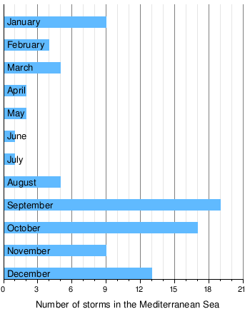
|
The numbers do not necessarily mean that all occurrences of medicanes have been fetched in particular before the end of the 1980s. With the development (and constant improvement) of satellite-based observations, the number count of clearly identified medicanes increased from the 1980s onward. There might be an additional impact from climate change in the frequency of the observed medicanes, but this is not deducible from the data.[ citation needed]
List of storms, by decade
|
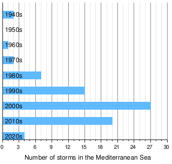
|
Deadly storms
The following is a list of all medicanes that caused deaths.
| Name | Year | Number of deaths |
|---|---|---|
| "1969" | 1969 | ≥ 600 |
| Numa | 2017 | 22 |
| Rolf | 2011 | 12 |
| Zorbas | 2018 | ≥ 6 (2 missing) |
| Ianos | 2020 | 4 (1 missing) |
| Qendresa | 2014 | 3 |
Tropical-like cyclones in the Black Sea
On a number of occasions, tropical-like storms similar to the tropical-like cyclones observed in the Mediterranean have formed in the Black Sea, including storms in 21 March 2002, 7–11 August 2002, [6] and 25–29 September 2005. [74] [7] The 25–29 September 2005 cyclone is particularly well-documented and investigated. No known cyclones in the Black Sea have attained hurricane strength.
Study
- Genesis and maintenance of "Mediterranean Hurricanes" - 1982
- The development of a Hurricane in the central Mediterranean Sea - 1996
- Observational analysis of a Mediterranean Hurricane over south-eastern Italy - 2006
- Mediterranean Sea Hurricane of 1995
- Warm waters may trigger Mediterranean hurricane - 2008
- Numerical Analysis of a Mediterranean Hurricane over Southeastern Italy
- Tropical cyclones may develop over Mediterranean Sea - 2008
- Analysis of the risk of tropical cyclone development over the Mediterranean Sea
- A Quasi - Tropical Cyclone Over The Western Mediterranean - 1996
- Tropical-like Mediterranean Storms: an analysis from satellite - 2005
- Analysis of the environments of seven Mediterranean tropical-like storms
- Tropical Cyclone in the Extratropics (Mediterranean): Observational Evidence and Synoptic Analysis - 1996
Notes
See also
- Tropical cyclone effects in Europe
- 1996 Lake Huron cyclone
- 2006 Central Pacific cyclone
- Subtropical Cyclone Katie
- Subtropical Cyclone Lexi
- 2018 Southeast Pacific subtropical cyclone
- Hurricane Catarina
- South Atlantic tropical cyclone
- Tropical cyclogenesis#Unusual_areas_of_formation
- List of notable tropical cyclones#Unusual_landfalls
- The Tropical Transition
References
Citations
- ^ a b Cavicchia, L.; von Storch, H.; Gualdi, S. (September 2014). "A long-term climatology of medicanes" (PDF). Climate Dynamics. 43 (5–6). Springer Science+Business Media: 1183–1195. Bibcode: 2014ClDy...43.1183C. doi: 10.1007/s00382-013-1893-7.
- ^ a b c d e f g Nastos P.T.; Karavana-Papadimou K.; Matsangouras I.T. (5 September 2015). "Tropical-like Cyclones in the Mediterranean: Impacts and Composite Daily Means and Anomalies of Synoptic Conditions" (PDF). University of Athens. Retrieved 22 November 2017.
- ^ Dussol Jean [@dussoljeanpierre] (November 18, 2017). "Not so rare" ( Tweet). Retrieved 26 December 2020 – via Twitter.
- ^ Angela Fritz (16 November 2017). "This is what's behind the dramatic, deadly flooding in Greece". Washington Post. Retrieved 17 November 2017.
- ^ a b Lagouvardos, K.; Karagiannidis, A.; Dafis, S.; Kalimeris, A.; Kotroni, V. (28 September 2021). "Ianos - A hurricane in the Mediterranean". Bulletin of the American Meteorological Society. 102 (9). American Meteorological Society: 1–31. doi: 10.1175/BAMS-D-20-0274.1. Retrieved 3 October 2021.
- ^ a b c "Miscellaneous Images". Met Office. Archived from the original on September 29, 2007. Retrieved 21 November 2015.
- ^ a b c V. V. Efimov; M. V. Shokurov; D. A. Yarovaya (2007). "Numerical Simulation of a Quasi-Tropical Cyclone over the Black Sea" (PDF). Marine Hydrophysical Institute. Retrieved 22 November 2017.
- ^ Sarah Fecht (22 November 2017). "What we know about medicanes—hurricane-like storms in the Mediterranean". Phys.org. Retrieved 23 November 2017.
-
^ Cite error: The named reference
Bianchinowas invoked but never defined (see the help page). - ^ a b Emanuel 2005, p. 217
-
^ Cite error: The named reference
jeffmasterswas invoked but never defined (see the help page). - ^ a b "TCFAQ F1) What regions around the globe have tropical cyclones and who". National Oceanic and Atmospheric Administration. Hurricane Research Division, Atlantic Oceanographic and Meteorological Laboratory. Retrieved 24 February 2014.
- ^ a b "2011 Tropical Bulletin Archive". National Oceanic and Atmospheric Administration. National Environmental Satellite, Data, and Information Service. 30 December 2011. Retrieved 23 February 2014.
- ^ a b 2015 Tropical Bulletin Archive
- ^ a b c 2016 Tropical Bulletin Archive
- ^ a b c d "Rare Mediterranean tropical-like cyclone forms, heading toward Greece". The Watchers. 18 November 2017. Retrieved 18 November 2017.
- ^ a b "EMMC on Twitter". European Medicane Monitoring Center. October 2017. Retrieved 19 November 2017.
-
^ Cite error: The named reference
AORswas invoked but never defined (see the help page). -
^ Cite error: The named reference
AORs3was invoked but never defined (see the help page). -
^ Cite error: The named reference
hnms2017was invoked but never defined (see the help page). - ^
a
b Cite error: The named reference
bessiewas invoked but never defined (see the help page). -
^ Cite error: The named reference
betawas invoked but never defined (see the help page). - ^
a
b Cite error: The named reference
DWD_Medicanewas invoked but never defined (see the help page). -
^ Cite error: The named reference
se200was invoked but never defined (see the help page). - ^ "OMM-JCOMM-GMDSS / World Marine Weather Forecast". Global Maritime Distress and Safety System. Météo-France. Retrieved 24 February 2014.
- ^ "OMM-JCOMM-GMDSS / World Marine Weather Forecast". Global Maritime Distress and Safety System. Météo-France. Retrieved 24 February 2014.
- ^ a b c Cavicchia et al. 2013, p. 7
- ^ Cavicchia et al. 2013, p. 18
- ^ a b c Homar et al. 2003, p. 1470
- ^ Emanuel 2005, p. 220
- ^ a b Cavicchia et al. 2013, p. 6
- ^ Cavicchia et al. 2013, p. 8
- ^ a b Tous & Romero 2013, p. 9
- ^ Tous & Romero 2013, p. 10
- ^ Anagnostopoulou et al. 2006, p. 13
- ^ Liza Lestor (13 February 2019). "Mediterranean hurricanes expected to increase in strength by end of century". Phys.org. Retrieved 22 April 2019.
- ^ Gaertner et al. 2007, p. 4
- ^ Romero & Emanuel 2013, p. 6000
- ^ a b Tous & Romero 2013, p. 8
- ^ Cavicchia et al. 2013, p. 14
- ^ Cavicchia et al. 2013, p. 15
- ^ a b Tous & Romero 2013, p. 3
- ^ Tous & Romero 2013, p. 5
- ^ a b Tous & Romero 2013, p. 6
- ^ Cavicchia & von Storch 2012, p. 2276
- ^ Fita et al. 2007, p. 43
- ^ Fita et al. 2007, p. 53
- ^ a b Miglietta et al. 2013, p. 2402
- ^ a b c Homar et al. 2003, p. 1469
- ^ a b Claud et al. 2010, p. 2211
- ^ Miglietta et al. 2013, p. 2404
- ^ a b c d e f g Pytharoulis et al. 2000, p. 262
- ^ http://www.storm2k.org/phpbb2/viewtopic.php?f=6&t=105343
- ^ Tonks, Sara; Miller, Brandon (25 October 2019). "A rare hurricane-like storm in the Mediterranean threatens Egypt and Israel". edition.cnn.com. CNN. Retrieved 1 November 2019.
- ^ "MODIS Web: Image of theDay". modis.gsfc.nasa.gov. NASA. 26 October 2019. Retrieved 16 October 2020.
- ^ Korosec, Marco (11 November 2019). "An impressive medicane #DETLEF in the western Mediterranean, making landfall in northern Algeria, Nov 11th". Severe Weather Europe. Retrieved 19 December 2020.
- ^ Celestial, Julie (12 November 2019). "Medicane "Trudy" (Detlef, Bernardo) makes landfall in Algeria". The Watchers. Retrieved 19 December 2020.
- ^ severe-weather.EU [@severeweatherEU] (November 11, 2019). "An impressive high-resolution satellite image of a rapidly developing #medicane north of the Algerian coast in the western Mediterranean today, Nov 11th. Image by NASA MODIS. Medicane is expected to make landfall in N Algeria this evening (update soon):" ( Tweet). Retrieved 26 December 2020 – via Twitter.
- ^ a b DR. JACK BEVEN'S IMAGES OF THE MEDITERRANEAN 'HURRICANE' (1995)
- ^ http://www.meteored.com/ram/UserFiles/Image/noviembre07/medicane4.jpg
- ^ http://www.meteonix.com/v3_prinot.asp?sub=597
- ^ http://www.storm2k.org/phpbb2/viewtopic.php?f=31&t=103908&start=0&st=0&sk=t&sd=a
- ^ http://www.storm2k.org/phpbb2/viewtopic.php?f=31&t=109859
- ^ http://universesandbox.com/forum/index.php/topic,1885.msg28147.html#msg28147
- ^ http://www.storm2k.org/phpbb2/viewtopic.php?f=31&t=112218
- ^ http://www.weather-photos.net/blog/?p=1305
- ^ http://www.storm2k.org/phpbb2/viewtopic.php?f=31&t=111711&star=20
- ^ http://www.accuweather.com/en/weather-news/mediterranean-storm-tempest-in/57519
- ^ http://weather.noaa.gov/pub/data/raw/wo/womq50.lfpw..txt
- ^ http://www.storm2k.org/phpbb2/viewtopic.php?f=54&t=112192&p=2205188
- ^ http://www.wunderground.com/blog/JeffMasters/comment.html?entrynum=1982&page=2
- ^ http://oceanweatherservices.com/blog1/about/author/ocean-weather-updates/
- ^
a
b Andrea Buzzi, Piero Malguzzi, and Guido Cioni (2014).
"Thermal structure and dynamical modeling of a Mediterranean Tropical-like cyclone" (PDF). University of Bologna. Retrieved 21 November 2017.
{{
cite web}}
: CS1 maint: multiple names: authors list ( link) - ^ a b V. V. Efimov; S. V. Stanichnyi; M. V. Shokurov; D. A. Yarovaya (19 March 2007). "Observations of a Quasi-Tropical Cyclone over the Black Sea" (PDF). Allerton Press. Retrieved 22 November 2017.
- ^ Tous & Romero 2013, p. 4
- ^ Fita et al. 2007, p. 45
- ^ Winstanley 1970, p. 393
- ^ a b Winstanley 1970, p. 396
- ^ a b Winstanley 1970, p. 392
- ^ Winstanley 1970, p. 390
- ^ a b Ernst & Matson 1983, p. 333
- ^ a b c Ernst & Matson 1983, p. 334
- ^ Reed et al. 2001, p. 187
- ^ Reed et al. 2001, p. 189
- ^ a b Ernst & Matson 1983, p. 337
- ^ Dr. Jeff Masters (7 November 2014). "Rare Medicane Hits Malta and Sicily With Tropical Storm-Like Conditions". Weather Underground. Retrieved 20 November 2017.
- ^ a b Cavicchia & von Storch 2012, p. 2280
- ^ a b c Pytharoulis et al. 2000, p. 263
- ^ a b c d Pytharoulis et al. 1999, p. 628
- ^ a b Pytharoulis et al. 2000, p. 264
- ^ Pytharoulis et al. 2000, p. 265
- ^ Pytharoulis et al. 2000, p. 266
- ^ Pytharoulis et al. 2000, p. 267
- ^ a b Cavicchia & von Storch 2012, p. 2281
- ^ a b c Cavicchia & von Storch 2012, p. 2282
- ^ Homar et al. 2003, p. 1473
- ^ Cavicchia & von Storch 2012, p. 2283
- ^ Homar et al. 2003, p. 1471
- ^ Cavicchia & von Storch 2012, p. 2284
- ^ a b 1990s Mediterranean Storms report
- ^ http://www.met.fu-berlin.de/de/wetter/maps/Analyse_20030916.gif
- ^ http://www.met.fu-berlin.de/de/wetter/maps/Analyse_20030920.gif
- ^ http://www.met.fu-berlin.de/de/wetter/maps/Analyse_20030921.gif
- ^ Ouali, A.; Chaabane, M.; Maalej, A.; Hannachi, A. (2006). "The 16-18 September 2003 Tunisian Flood" (PDF). European Geosciences Union. Retrieved 1 December 2017.
- ^ I CICLONI TROPICALI MEDITERRANEI (in Italian)
- ^ http://www.met.fu-berlin.de/de/wetter/maps/Analyse_20031015.gif
- ^ http://www.met.fu-berlin.de/de/wetter/maps/Analyse_20031016.gif
- ^ http://www.met.fu-berlin.de/de/wetter/maps/Analyse_20031017.gif
- ^ http://www.met.fu-berlin.de/de/wetter/maps/Analyse_20031019.gif
- ^ http://www.met.fu-berlin.de/de/wetter/maps/Analyse_20031021.gif
- ^ http://www.met.fu-berlin.de/de/wetter/maps/Analyse_20051208.gif
- ^ http://www.met.fu-berlin.de/de/wetter/maps/Analyse_20051209.gif
- ^ http://www.met.fu-berlin.de/de/wetter/maps/Analyse_20051210.gif
- ^ http://www.met.fu-berlin.de/de/wetter/maps/Analyse_20051211.gif
- ^ http://www.met.fu-berlin.de/de/wetter/maps/Analyse_20051213.gif
- ^ http://www.met.fu-berlin.de/de/wetter/maps/Analyse_20051214.gif
- ^ http://www.met.fu-berlin.de/de/wetter/maps/Analyse_20051215.gif
- ^ http://www.met.fu-berlin.de/de/wetter/maps/Analyse_20051216.gif
- ^ a b Claud et al. 2010, p. 2203
- ^ a b c d e Moscatello et al. 2008, p. 4374
- ^ http://www.met.fu-berlin.de/de/wetter/maps/Analyse_20060925.gif
- ^ Jean-Pierre Chaboureau; Florian Pantillon; Dominique Lambert; Evelyne Richard; Chantal Claudb (10 November 2011). "Tropical transition of a Mediterranean storm by jet crossing" (PDF). Royal Meteorological Society. Retrieved 22 November 2017.
- ^ Moscatello et al. 2008, p. 4375
- ^ http://www.met.fu-berlin.de/de/wetter/maps/Analyse_20090127.gif
- ^ Gary Padgett (July 21, 2009). "Monthly Tropical Weather Newsletter: January 2009". Typhoon 2000. Retrieved February 15, 2010.
- ^ http://www.met.fu-berlin.de/de/wetter/maps/Analyse_20090129.gif
- ^ http://www.met.fu-berlin.de/de/wetter/maps/Analyse_20090203.gif
- ^ Meldungen und Analysen zur Mittelmeer-Cut-Off-Superzyklone!
- ^ a b Ilmer, P. (8 December 2011). "Lebensgeschichte: Tiefdruckgebiet Rolf". Freie Universität Berlin (in German). Institut für Meteorologie. Retrieved 23 February 2014.
- ^ Europe Weather Analysis on 2011-11-05
- ^ Europe Weather Analysis on 2011-11-06
- ^ Europe Weather Analysis on 2011-11-07
- ^ a b "Tropical Storm 01M (INVEST 99L) Bulletins". National Environmental Satellite, Data, and Information Service (NESDIS). NOAA Satellite and Information Service. 2011-11-09. Retrieved 2011-11-13.
- ^ Europe Weather Analysis on 2011-11-10
- ^ "November 2011 Monthly Cat Recap" (PDF). Aon Benfield. December 6, 2011. p. 5. Retrieved September 23, 2017.
- ^ Europe Weather Analysis on 2012-01-31
- ^ Europe Weather Analysis on 2012-02-02
- ^ Europe Weather Analysis on 2012-02-03
- ^ Europe Weather Analysis on 2012-02-04
- ^ Europe Weather Analysis on 2012-02-05
- ^ Europe Weather Analysis on 2012-02-06
- ^ a b Kyriati Metheneti (February 7, 2012). "Rapid Cyclogenesis over Ionian Sea cancelled all marine activities and caused flooding and structural damage in early February 2012". EUMETSAT. Retrieved September 23, 2017.
- ^ Europe Weather Analysis on 2012-02-07
- ^ Europe Weather Analysis on 2012-02-08
- ^ Europe Weather Analysis on 2012-02-09
- ^ Europe Weather Analysis on 2012-02-10
- ^ Europe Weather Analysis on 2012-02-11
- ^ http://www.met.fu-berlin.de/de/wetter/maps/Analyse_20141105.gif
- ^ a b Ben Henson (16 November 2017). "More Heavy Rain—and a Medicane—Are Possible as Cyclone Numa Churns Near Greece". Weather Underground. Retrieved 17 November 2017.
- ^ Dr. Jeff Masters (November 7, 2014). "Rare Medicane Hits Malta and Sicily With Tropical Storm-Like Conditions". Retrieved November 7, 2014.
- ^ Peppe Caridi (November 7, 2014). "Maltempo, Lampedusa letteralmente devastata dal ciclone tropicale [FOTO]" (in French). Retrieved November 7, 2014.
- ^ http://www.met.fu-berlin.de/de/wetter/maps/Analyse_20141108.gif
- ^ http://www.met.fu-berlin.de/de/wetter/maps/Analyse_20141109.gif
- ^ http://www.met.fu-berlin.de/de/wetter/maps/Analyse_20141110.gif
- ^ http://www.met.fu-berlin.de/de/wetter/maps/Analyse_20141111.gif
- ^ http://www.met.fu-berlin.de/de/wetter/maps/Analyse_20141124.gif
- ^ http://www.met.fu-berlin.de/de/wetter/maps/Analyse_20141126.gif
- ^ http://www.met.fu-berlin.de/de/wetter/maps/Analyse_20141127.gif
- ^ http://www.met.fu-berlin.de/de/wetter/maps/Analyse_20141129.gif
- ^ http://www.met.fu-berlin.de/de/wetter/maps/Analyse_20141130.gif
- ^ http://www.met.fu-berlin.de/de/wetter/maps/Analyse_20141201.gif
- ^ http://www.met.fu-berlin.de/de/wetter/maps/Analyse_20141202.gif
- ^ http://www.met.fu-berlin.de/de/wetter/maps/Analyse_20141203.gif
- ^ http://www.met.fu-berlin.de/de/wetter/maps/Analyse_20141204.gif
- ^ http://www.met.fu-berlin.de/de/wetter/maps/Analyse_20141204.gif
- ^ http://www.met.fu-berlin.de/de/wetter/maps/Analyse_20141206.gif
- ^ http://www.met.fu-berlin.de/de/wetter/maps/Analyse_20141207.gif
- ^ "A swirling area of low pressure over Lazio on 3 December showed a clear eye - indicating a medicane". EUMETSAT. 3 December 2014. Retrieved 3 December 2017.
- ^ http://www.met.fu-berlin.de/de/wetter/maps/Analyse_20141208.gif
- ^ http://www.met.fu-berlin.de/de/wetter/maps/Analyse_20141209.gif
- ^ http://www.met.fu-berlin.de/de/wetter/maps/Analyse_20141210.gif
- ^ http://www.met.fu-berlin.de/de/wetter/maps/Analyse_20141211.gif
- ^ http://www.met.fu-berlin.de/de/wetter/maps/Analyse_20141212.gif
- ^ "Europe Weather Analysis on 2015-09-30". Free University of Berlin. 30 September 2015. Retrieved 1 December 2017.
- ^ "Europe Weather Analysis on 2015-10-01". Free University of Berlin. 1 October 2015. Retrieved 1 December 2017.
- ^ "Europe Weather Prognosis on 2015-10-01". Free University of Berlin. 1 October 2015. Retrieved 1 December 2017.
- ^ a b c "Category 1 medicane system brings landslides and violent floods to Italy and France". The Watchers. 2 October 2015. Retrieved 30 September 2016.
- ^ Michael Idato (5 October 2015). "Deaths after 'medicane' storm hits Cannes ahead of Mipcom TV event". The Sydney Morning Herald. Retrieved 1 December 2017.
- ^ "Europe Weather Analysis on 2015-10-02". Free University of Berlin. 2 October 2015. Retrieved 1 December 2017.
- ^ "Europe Weather Analysis on 2015-10-04". Free University of Berlin. 4 October 2015. Retrieved 1 December 2017.
- ^ http://www.met.fu-berlin.de/de/wetter/maps/Analyse_20161027.gif
- ^ http://www.met.fu-berlin.de/de/wetter/maps/Analyse_20161029.gif
- ^ Halloween Surprise: Rare Tropical Storm Forms in Mediterranean Sea
- ^ Cyclonic Storm in the Mediterranean
- ^ Rare tropical storm forms in the Mediterranean Sea
- ^ http://www.met.fu-berlin.de/de/wetter/maps/Analyse_20161030.gif
- ^ ""Medicane Trixi"" (in German). Deutscher Wetterdienst. November 1, 2016. Retrieved October 2, 2017.
- ^ A Tropical Cyclone in the Mediterranean Sea
- ^ http://www.met.fu-berlin.de/de/wetter/maps/Analyse_20161101.gif
- ^ http://www.met.fu-berlin.de/de/wetter/maps/Analyse_20161102.gif
- ^ "Europe Weather Analysis on 2017-10-23". Free University of Berlin. 23 October 2017. Retrieved 20 November 2017.
- ^ "Europe Weather Analysis on 2017-10-25". Free University of Berlin. 25 October 2017. Retrieved 20 November 2017.
- ^ "Europe Weather Analysis on 2017-10-26". Free University of Berlin. 26 October 2017. Retrieved 20 November 2017.
- ^ "Europe Weather Analysis on 2017-10-27". Free University of Berlin. 27 October 2017. Retrieved 20 November 2017.
- ^ "Europe Weather Analysis on 2017-11-16". Free University of Berlin. 16 November 2017. Retrieved 17 November 2017.
- ^ "Europe Weather Analysis on 2017-11-17". Free University of Berlin. 17 November 2017. Retrieved 18 November 2017.
- ^ @meteofrance (November 17, 2017). "#Numa a désormais les caractéristiques d'un #medicane 🌀, dépression méditerranéenne subtropicale #Grèce #Italie #Balkans" ( Tweet) (in French) – via Twitter.
- ^ ""Numa" has become a category 1 Medicane on the MTCIS scale with sustained winds of 115 km/h (71.46 mph)". European Mediterranean Medicane Center. 18 November 2017. Retrieved 18 November 2017.
- ^ "Europe Weather Analysis on 2017-11-19". Free University of Berlin. 19 November 2017. Retrieved 19 November 2017.
- ^ "Europe Weather Analysis on 2017-11-20". Free University of Berlin. 20 November 2017. Retrieved 20 November 2017.
- ^ a b "Global Catastrophe Recap - November 2017" (PDF). Aon Benfield. 7 December 2017. p. 5. Retrieved 26 September 2018.
- ^ "At least 11 die as deadly flash floods hit Greece - The Weather Channel". Weather.com. Retrieved 17 November 2017.
- ^ Angela M. Fritz. "This is what's behind the dramatic, deadly flooding in Greece". Washington Post. Retrieved 17 November 2017.
- ^ Everton Fox (19 November 2017). "Storm Numa forms in in the Mediterranean". Al Jazeera. Retrieved 20 November 2017.
- ^ "No Link between Hurricane Numa and Deadly Floods in Africa, say Meteorologists". 22 November 2017. Retrieved 23 November 2017.
- ^ "Extended Forecast Tue 25 Sep 2018 19:50". ESTOFEX. 25 September 2018. Retrieved 5 October 2018.
- ^ "Extended Forecast Wed 26 Sep 2018 20:13". ESTOFEX. 26 September 2018. Retrieved 5 October 2018.
- ^ "Europe Weather Analysis on 2018-9-27". Free University of Berlin. 27 September 2018. Retrieved 29 September 2018.
- ^ a b Jeff Masters (September 29, 2018). "Tropical Storm-Like Medicane Hits Greece". Weather Underground. Retrieved September 29, 2018.
- ^ "Mesoscale Discussion Sat 29 Sep 2018 12:29". ESTOFEX. 29 September 2018. Retrieved 5 October 2018.
- ^ "Europe Weather Analysis on 29 September 2018 00 UTC" (GIF). Free University of Berlin (in German). Deutscher Wetterdienst. 29 September 2018. Retrieved 29 September 2018.
- ^ a b "Xenophon Storm Could Turn into Mediterranean Hurricane, Meteo Warns". The National Herald. 27 September 2018. Retrieved 29 September 2018.
- ^ "Storm Zorba bears down on Greece, Athens area also alerted". The Washington Post. Associated Press. 28 September 2018. Retrieved 29 September 2018.
- ^ a b "Storm hits Greek capital with downpours, gale-force winds as it continues east". Kathimerini English Edition. 29 September 2018. Retrieved 29 September 2018.
- ^ "Europe Weather Analysis on 2018-10-01". Free University of Berlin. 1 October 2018. Retrieved 3 October 2018.
- ^ "Europe Weather Analysis on 2018-10-02". Free University of Berlin. 2 October 2018. Retrieved 3 October 2018.
- ^ Simon Veazey (29 September 2018). "Rare Hurricane-Like Medicane Storm Hits Europe". The Epoch Times. Retrieved 29 September 2018.
- ^ Jonathan Belles (29 September 2018). "A Medicane Is Swirling in the Mediterranean Sea Into Greece: Here's What That Means". The Weather Channel. Retrieved 29 September 2018.
- ^ "Tunisia floods kill at least 4, cause major damage". Associated Press. 23 September 2018. Retrieved 29 September 2018.
- ^ a b Elinda Labropoulou; Brandon Miller (29 September 2018). "'Medicane,' a rare, hurricane-like storm, is on track to hit Europe". CNN. Retrieved 29 September 2018.
- ^ Nick Austin (3 October 2018). "Cyclone floods parts of Greece, two people missing". FreightWaves. Retrieved 3 October 2018.
- ^ "A strong 'medicane' named Ianos is forecast to bring hurricane-like conditions to Greece". The Washington Post. 17 September 2020.
-
^
Weekly Weather and Crop Bulletin (PDF). usda.library.cornell.edu (Report). Vol. 107.
United States Department of Agriculture. 22 September 2020. p. 28. Retrieved 24 September 2020.
{{
cite report}}
: CS1 maint: url-status ( link) - ^ https://www.meteo.gr/article_view.cfm?entryID=1481&fbclid=IwAR23JfGR9t0_u8DTko2YJBYmPrpZqqeYZvT9fZcvoTs9aL9h-aA-CF9r4k8
- ^ a b Kelly, Maura. "Storm Janus develops into medicane, will wallop Greece with flooding rain, strong winds". AccuWeather. Retrieved 16 September 2020.
- ^ "Thema des Tages – Medicane UDINE über dem Ionischen Meer". www.dwd.de (in German). 16 September 2020. Retrieved 16 September 2020.
-
^
"Medicane Centre Twitter". Twitter. Retrieved 14 September 2020.
{{ cite web}}:|archive-date=requires|archive-url=( help)CS1 maint: url-status ( link) - ^ "Hellup!" (in Dutch). 16 September 2020.
- ^ "Cyclone Ianos: Two dead as 'medicane' sweeps across Greece". BBC. 19 September 2020.
- ^ "Cyclone Ianos: Two dead and one missing after 'rare extreme weather phenomenon' hits Greece". euronews.com. 19 September 2020.
- ^ Mediterranean Cyclone Centre [@medicane_centre] (November 22, 2020). "OUTLOOK (MEDI / BLACK SEA) NOV 22, 2020 12:00 UTC MEDISTORM 02M/DAVID | Advisory 1...MEDISTORM DAVID DEVELOPS JUST OFF THE COAST OF TUNISIA... ...LANDFALL EXPECTED LATER TODAY AS RAIN COMES ASHORE NEAR SOUSSE... more at https://medicanecentre.org graphic incoming" ( Tweet). Retrieved 28 November 2020 – via Twitter.
- ^ Bianchino, Daniele [@prometheiplanum] (November 22, 2020). "Tropical storm Masinissa / David probably T3.0 dvorak (51kt gust Mahdia المهدية). Tcfp-Noaa correctly predicted the possibility of tropical formation over Mediterranean: @metoffice @metofficestorms @meteofrance @TropicalWxTrack @tAfFLEduxJX3dcS #medicane #تونس #المهديه #TLC" ( Tweet). Retrieved 28 November 2020 – via Twitter.
- ^ "Tropical storm Masinissa (medicane) 2020". Youtube.com. 26 November 2020. Retrieved November 27, 2020.
- ^ Teo Blašković (16 December 2020). "Severe Medistorm "Elaina" forms near Cyprus, landfall expected in Lebanon on December 17". watchers.news. The Watchers. Retrieved 20 December 2020.
- ^ a b Daniele Bianchino [@PrometheiPlanum] (December 16, 2020). "Subtropical cyclones have No organized convection in the center and are connected at the fronts. This is certainly a tropical cyclone T2.5 / T3.0 intensity (informally called #medicane over the Mediterranean). #Andira / #Elaina Noaa-metoffice: Tropical Storm 03M:" ( Tweet). Retrieved December 20, 2020 – via Twitter.
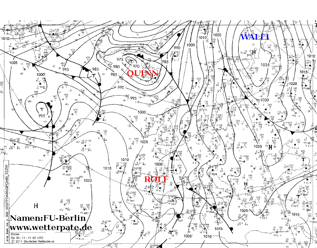
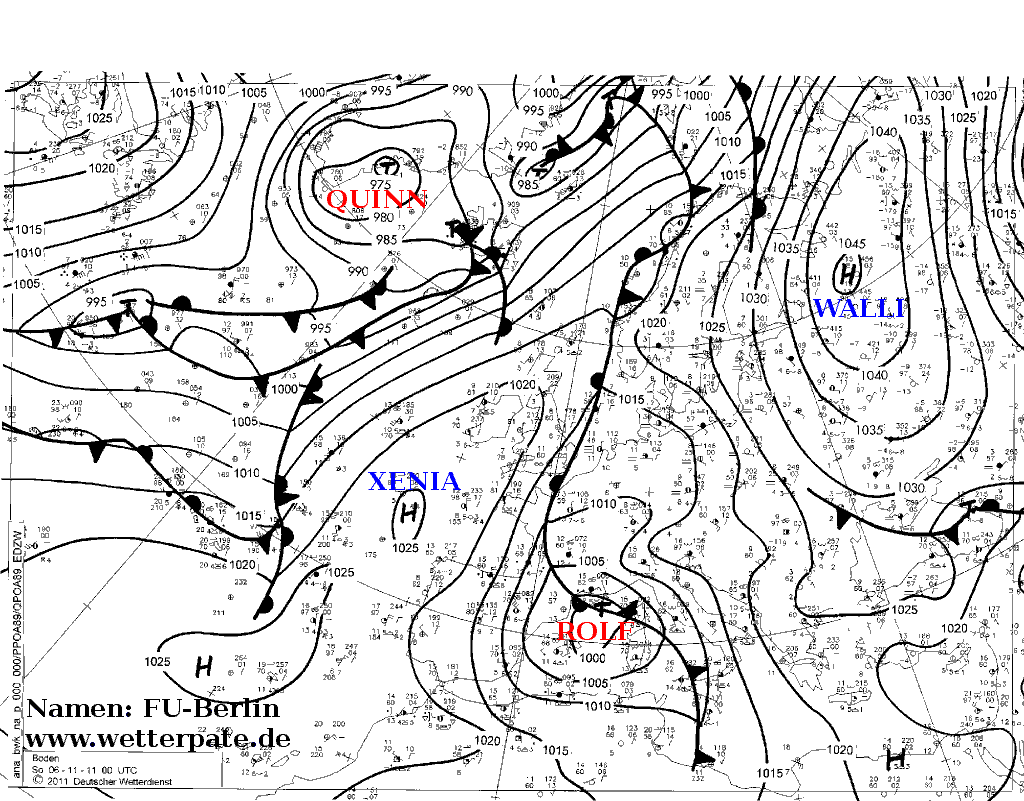
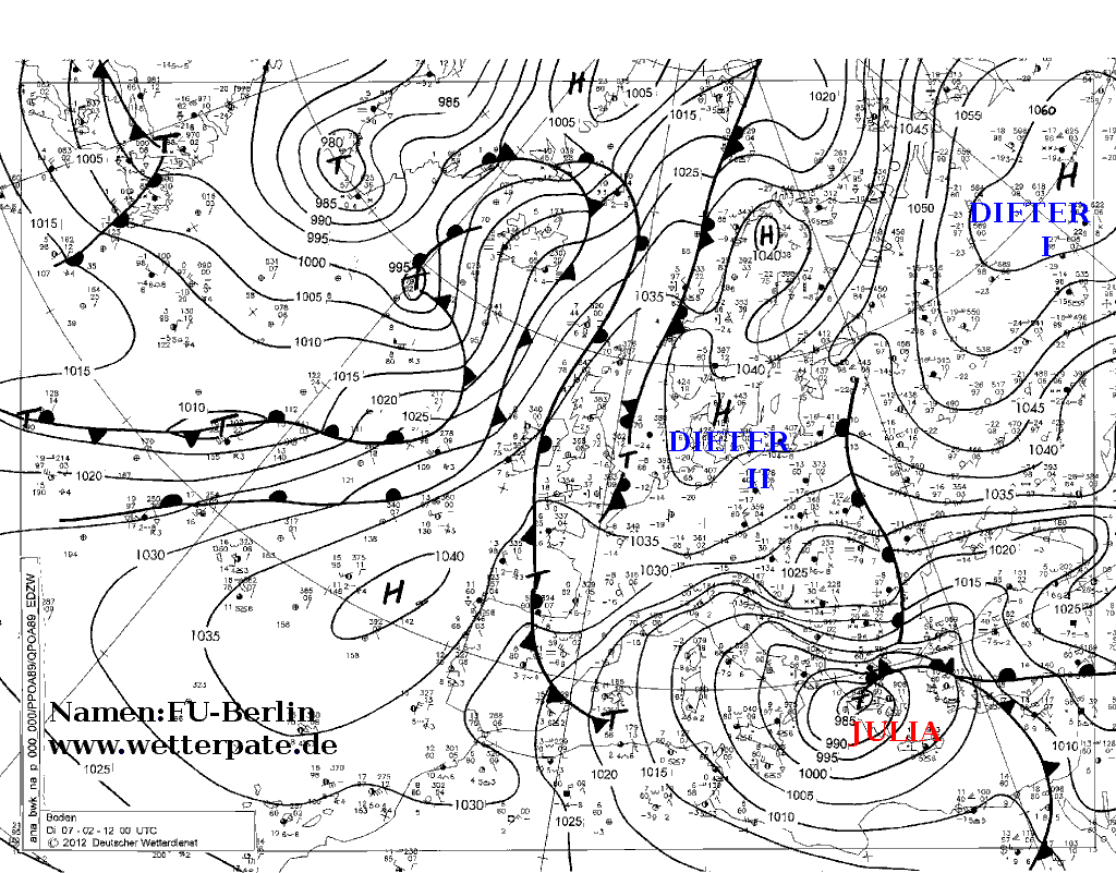
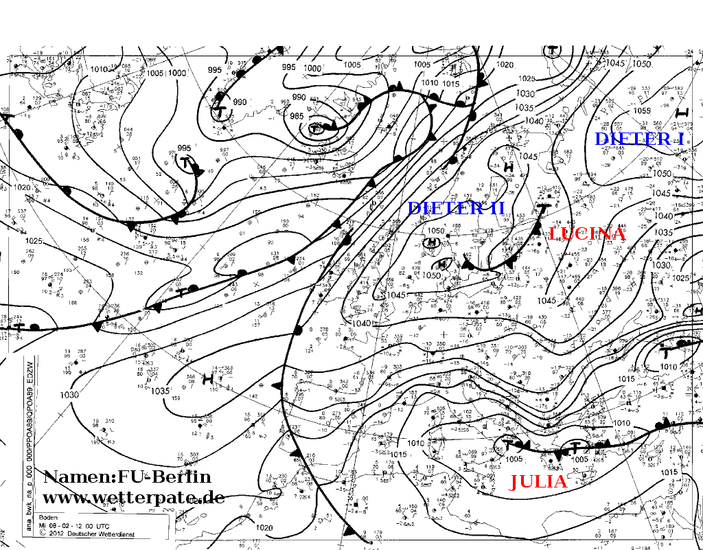
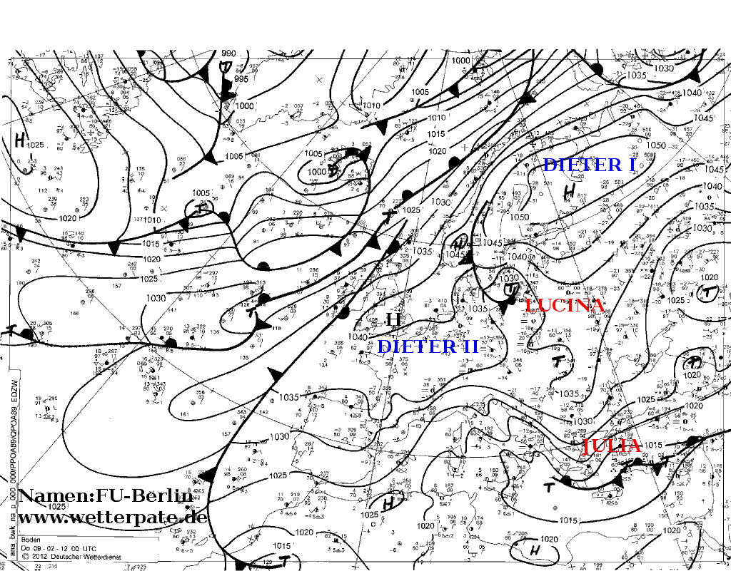
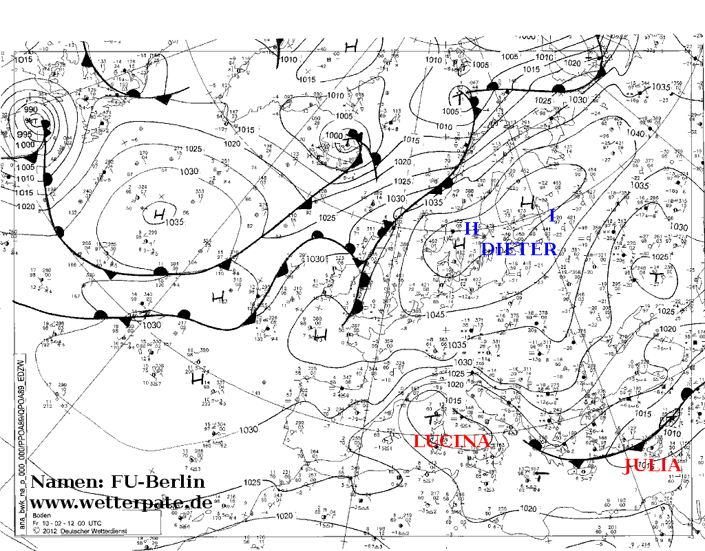
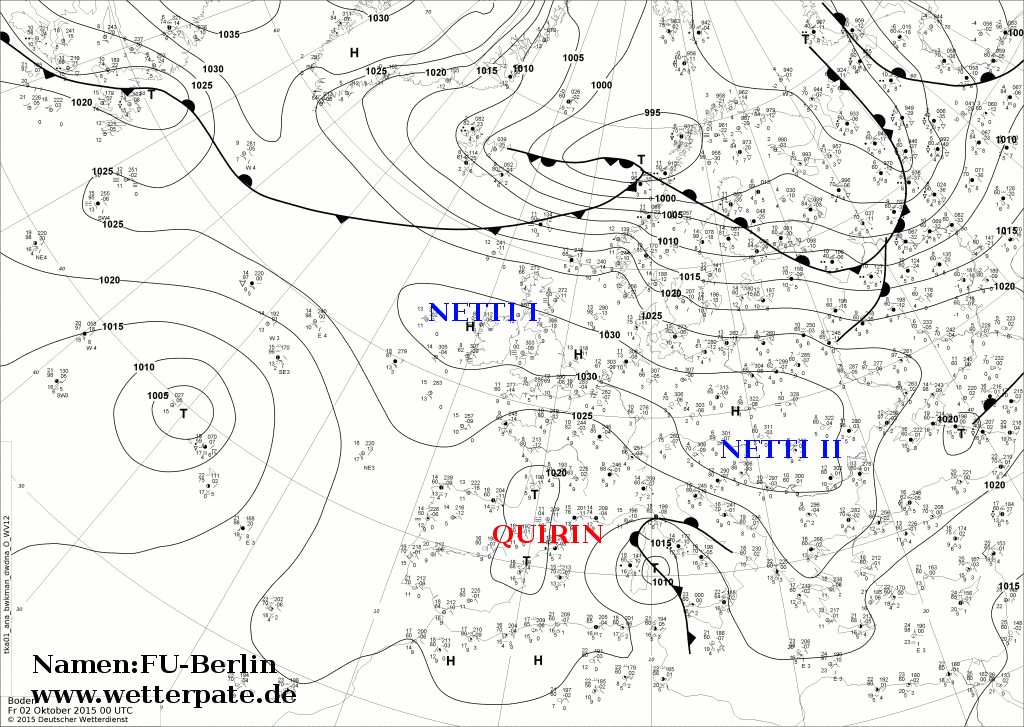
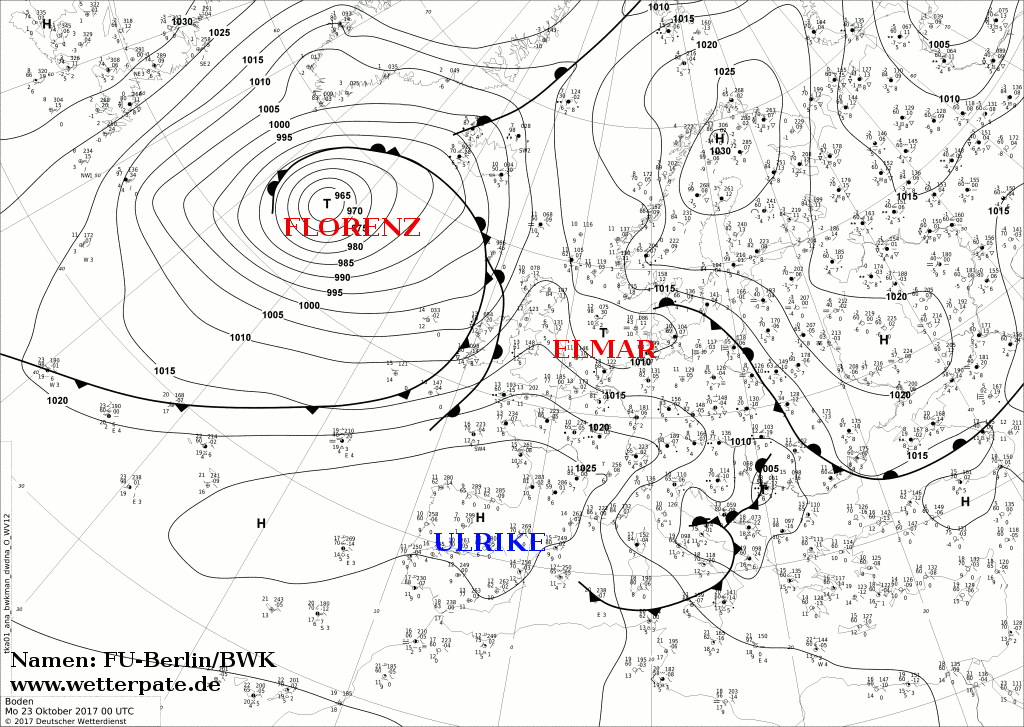
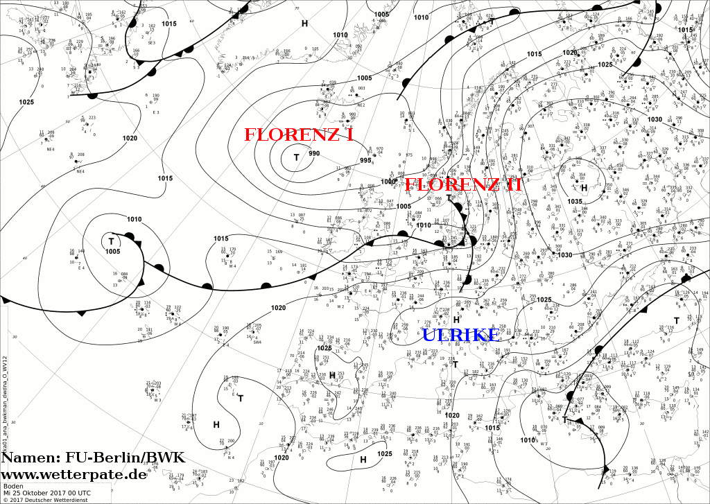
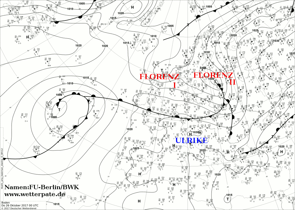
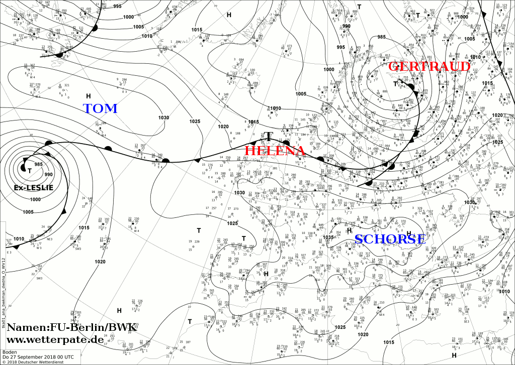
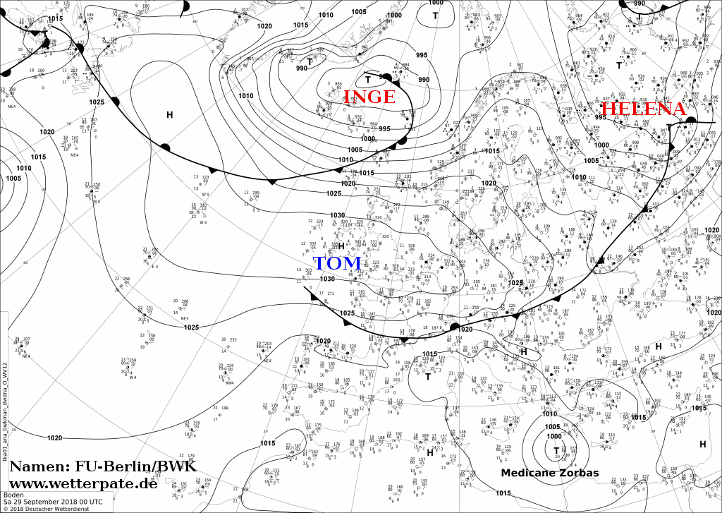
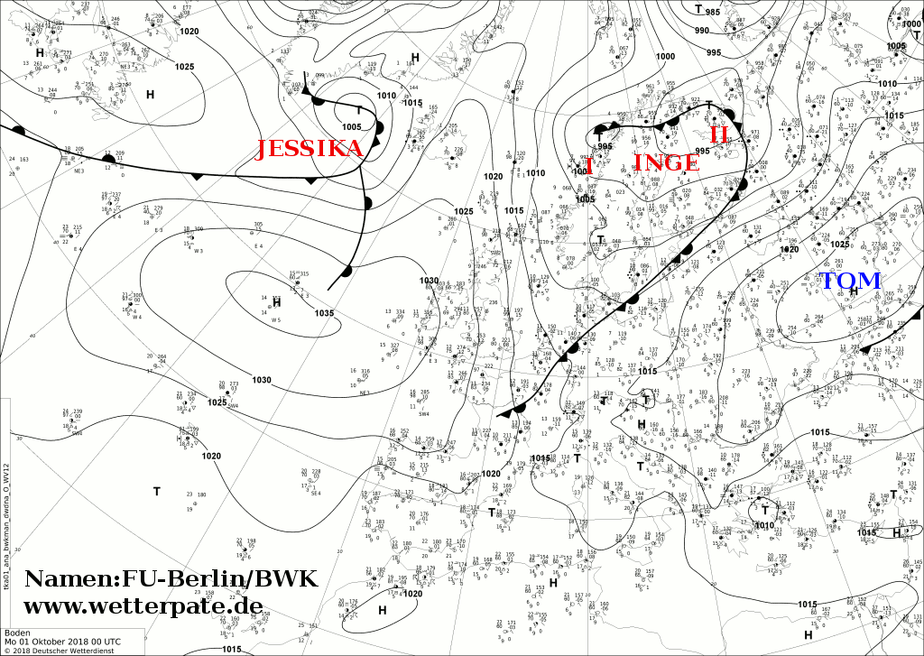
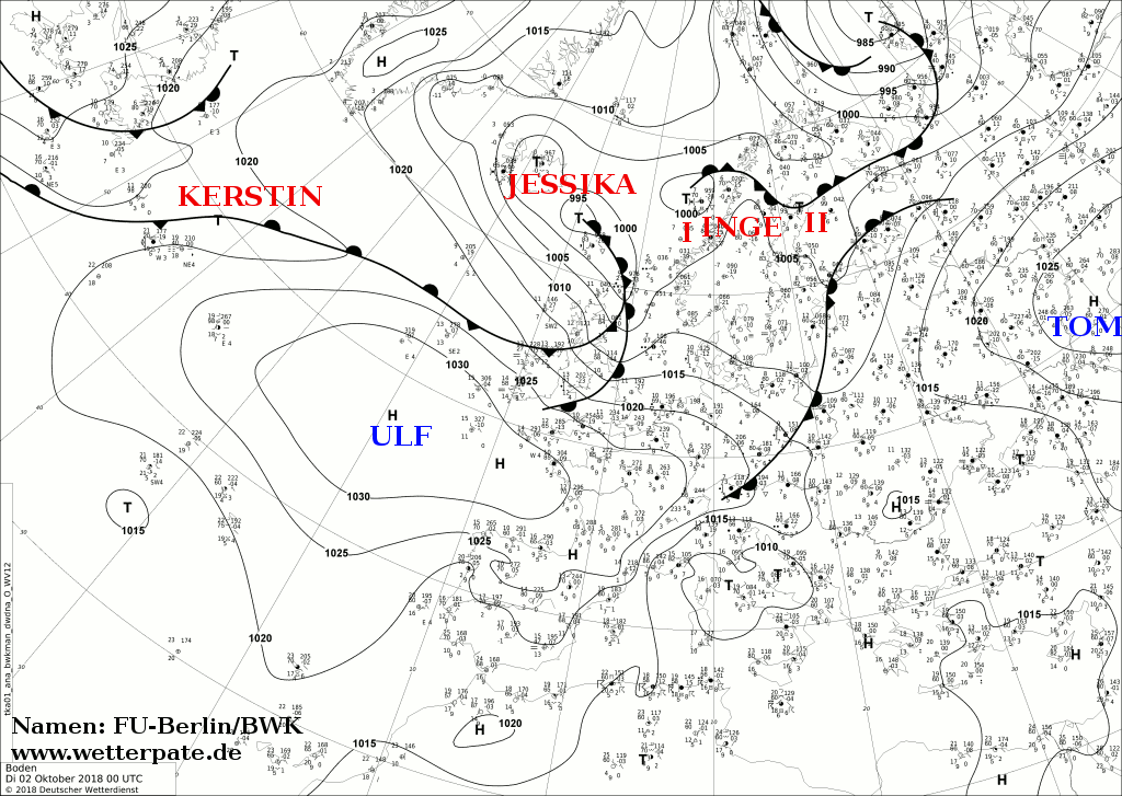
Bibliography
- Anagnostopoulou, C.; Tolika, K.; Flocas, H.; Maheras, P. (January 2006).
"Cyclones in the Mediterranean region: present and future climate scenarios derived from a general circulation model (HadAM3P)" (PDF). Advances in Geosciences. 7. European Geosciences Union: 9–14.
doi:
10.5194/adgeo-7-9-2006.
{{
cite journal}}
: CS1 maint: unflagged free DOI ( link) - Bakkensen, L. A. (January 2016). "Estimating the Damages of Mediterranean Hurricanes" (PDF). University of Arizona. Retrieved 22 November 2017.
- Blier, W.; Ma, Q. (1997). A Mediterranean Sea hurricane?. Preprints, 22nd Conference on Hurricanes and Tropical Meteorology. American Meteorological Society. pp. 592–595.
- Cavicchia, L.; von Storch, H. (November 2012). "The simulation of medicanes in a high-resolution regional climate model" (PDF). Climate Dynamics. 39 (9–10). Springer Science+Business Media: 2273–2290. Bibcode: 2012ClDy...39.2273C. doi: 10.1007/s00382-011-1220-0.
- Cavicchia, L.; von Storch, H.; Gualdi, S. (October 2014). "Mediterranean tropical-like cyclones in present and future climate" (PDF). Journal of Climate. 27 (19). American Meteorological Society: 7493–7501. Bibcode: 2014JCli...27.7493C. doi: 10.1175/JCLI-D-14-00339.1.
- Cerrai, D. (January 2015). "Moisture and Potential Vorticity in Medicanes: Theoretical Approach and Case Studies" (PDF). University of Bologna. Retrieved 22 November 2017.
- Claud, C.; Alhammoud, B.; Funatsu, B.M.; Chaboureau, J.-P. (October 2010).
"Mediterranean hurricanes: large-scale environment and convective and precipitating areas from satellite microwave observations" (PDF). Natural Hazards and Earth System Sciences. 10 (10). European Geosciences Union: 2199–2213.
Bibcode:
2010NHESS..10.2199C.
doi:
10.5194/nhess-10-2199-2010.
{{
cite journal}}
: CS1 maint: unflagged free DOI ( link) - Conte, D.; Miglietta, M.M.; Levizzani, V. (July 2011). "Analysis of instability indices during the development of a Mediterranean tropical-like cyclone using MSG-SEVIRI products and the LAPS model". Atmospheric Research. 101 (1–2). Elsevier: 264–279. Bibcode: 2011AtmRe.101..264C. doi: 10.1016/j.atmosres.2011.02.016.
- Dafis, S.; Rysman, J.F.; Claud, C.; Flaounas, E. (July 2018). "Remote sensing of deep convection within a tropical‐like cyclone over the Mediterranean Sea" (PDF). Atmospheric Science Letters. 19 (6). Royal Meteorological Society: 283–286. doi: 10.1002/asl.823.
- Davolio, S.; Miglietta, M.M.; Moscatello, A.; Pacifico, A.; Buzzi, A.; Rotunno, R. (April 2009).
"Numerical forecast and analysis of a tropical-like cyclone in the Ionian Sea" (PDF). Natural Hazards and Earth System Sciences. 9 (2). European Geosciences Union: 551–562.
doi:
10.5194/nhess-9-551-2009.
{{
cite journal}}
: CS1 maint: unflagged free DOI ( link) - Emanuel, K. (June 2005).
"Genesis and maintenance of 'Mediterranean hurricanes'" (PDF). Advances in Geosciences. 2. European Geosciences Union: 217–220.
doi:
10.5194/adgeo-2-217-2005.
{{
cite journal}}
: CS1 maint: unflagged free DOI ( link) - Ernst, J.A.; Matson, M. (November 1983). "A Mediterranean tropical storm?". Weather. 38 (11). Royal Meteorological Society: 332–337. Bibcode: 1983Wthr...38..332E. doi: 10.1002/j.1477-8696.1983.tb04818.x.
- Fita, L.; Romero, R.; Luque, A.; Emanuel, K.; Ramis, C. (January 2007).
"Analysis of the environments of seven Mediterranean tropical-like storms using an axisymmetric, nonhydrostatic, cloud resolving model" (PDF). Natural Hazards and Earth System Sciences. 7 (1). European Geosciences Union: 41–56.
doi:
10.5194/nhess-7-41-2007.
{{
cite journal}}
: CS1 maint: unflagged free DOI ( link) - Fita, L.; Romero, R.; Luque, A.; Emanuel, K.; Ramis, C. (2007). "Tropical-like Mediterranean Storms: an analysis from satellite" (PDF). Balearic Islands University. Retrieved 21 November 2017.
- Gaertner, M.A.; Jacob, D.; Gil, V.; Domínguez, M.; Padorno, E.; Sánchez, E.; Castro, M. (July 2007). "Tropical cyclones over the Mediterranean Sea in climate change simulations". Geophysical Research Letters. 34 (14). American Geophysical Union: L14711. Bibcode: 2007GeoRL..3414711G. doi: 10.1029/2007GL029977.
- Homar, V.; Romero, R.; Stensrud, D.J.; Ramis, C.; Alonso, S. (April 2003). "Numerical diagnosis of a small, quasi-tropical cyclone over the western Mediterranean: Dynamical vs. boundary factors". Quarterly Journal of the Royal Meteorological Society. 129 (590). Royal Meteorological Society: 1469–1490. Bibcode: 2003QJRMS.129.1469H. doi: 10.1256/qj.01.91.
- Lagouvardos, K.; Kotroni, V.; Nickovic, S.; Kallos, D.; Tremback, C.J. (July 1999). "Observations and model simulations of a winter sub‐synoptic vortex over the central Mediterranean" (PDF). Meteorological Applications. 6 (4). Royal Meteorological Society: 371–383. doi: 10.1017/S1350482799001309.
- Levizzani, V.; Laviola, S.; Malvaldi, A.; Miglietta, M.M.; Cattani, E. (20 October 2012). "Severe storms over the Mediterranean Sea: A satellite and model analysis" (PDF). Institute of Atmospheric Sciences and Climate. Retrieved 3 December 2017.
- Mazon, J.; Lupo, A. (20 May 2017). "Sensitivity of a Mediterranean Tropical-Like Cyclone to Different Model Configurations and Coupling Strategies". MDPI. Retrieved 22 November 2017.
- Miglietta, M.M.; Moscatello, A.; Conte, D.; Mannarini, G.; Lacorata, G.; Rotunno, R. (July 2011). "Numerical analysis of a Mediterranean 'hurricane' over south-eastern Italy: Sensitivity experiments to sea surface temperature". Atmospheric Research. 101 (1–2). Elsevier: 412–426. Bibcode: 2011AtmRe.101..412M. doi: 10.1016/j.atmosres.2011.04.006.
- Miglietta, M.M.; Mastrangelo, D.; Conte, D. (February 2015). "Influence of physics parameterization schemes on the simulation of a tropical-like cyclone in the Mediterranean Sea". Atmospheric Research. 153 (1). Elsevier: 360–375. Bibcode: 2015AtmRe.153..360M. doi: 10.1016/j.atmosres.2014.09.008.
- Miglietta, M.M.; Laviola, S.; Malvaldi, A.; Conte, D.; Levizzani, V.; Price, C. (May 2013). "Analysis of tropical-like cyclones over the Mediterranean Sea through a combined modeling and satellite approach". Geophysical Research Letters. 40 (10). American Geophysical Union: 2400–2405. Bibcode: 2013GeoRL..40.2400M. doi: 10.1002/grl.50432.
- Moscatello, A.; Miglietta, M.M.; Rotunno, R. (October 2008). "Observational analysis of a Mediterranean 'hurricane' over southeastern Italy" (PDF). Weather. 63 (10). Royal Meteorological Society: 306–311. Bibcode: 2008Wthr...63..306M. doi: 10.1002/wea.231.
- Moscatello, A.; Miglietta, M.M.; Rotunno, R. (November 2008). "Numerical analysis of a Mediterranean 'hurricane' over southeastern Italy" (PDF). Monthly Weather Review. 136 (11). American Meteorological Society: 4373–4397. Bibcode: 2008MWRv..136.4373M. doi: 10.1175/2008MWR2512.1.
- Pantillon, F.P.; Chaboureau, J.-P.; Mascart, P.J. (3 June 2013). "Predictability of a Mediterranean Tropical-Like Storm Downstream of the Extratropical Transition of Hurricane Helene (2006)". American Meteorological Society. Retrieved 30 November 2017.
- Pedro C. Fernández Sanz. "Los medicanes o bajas mesoescalares con apariencia de ciclón tropical en la cuenca mediterránea: algunos casos de 2007" (in Spanish). Retrieved 2010-06-03.
- Picornell, M.A.; Campins, J.; Jansà, A. (7 May 2014). "Detection and thermal description of medicanes from numerical simulation" (PDF). Copernicus Publications. Retrieved 1 December 2017.
- Pytharoulis, I.; Craig, G.C.; Ballard, S.P. (June 1999). "Study of the Hurricane-like Mediterranean Cyclone of January 1995" (PDF). Physics and Chemistry of the Earth. 24 (6). Elsevier B.V.: 627–632. Bibcode: 1999PCEB...24..627P. doi: 10.1016/S1464-1909(99)00056-8.
- Pytharoulis, I.; Craig, G.C.; Ballard, S.P. (September 2000). "The hurricane-like Mediterranean cyclone of January 1995". Meteorological Applications. 7 (3). Royal Meteorological Society: 261–279. Bibcode: 2000MeApp...7..261P. doi: 10.1017/S1350482700001511.
- Reale, O.; Atlas, R. (February 1998). "A Tropical-Like Cyclone in the Extratropics" (PDF). ICTP. Retrieved 30 November 2017.
- Reed, R.J.; Kuo, Y.-H.; Albright, M.D.; Gao, K.; Guo, Y.-R.; Huang, W. (April 2001). "Analysis and modeling of a tropical-like cyclone in the Mediterranean Sea". Meteorology and Atmospheric Physics. 76 (3–4). Springer Science+Business Media: 183–202. Bibcode: 2001MAP....76..183R. doi: 10.1007/s007030170029.
- Romero, R.; Emanuel, K. (June 2013). "Medicane risk in a changing climate" (PDF). Journal of Geophysical Research: Atmospheres. 118 (12). American Geophysical Union: 5992–6001. Bibcode: 2013JGRD..118.5992R. doi: 10.1002/jgrd.50475.
- Tous, M.; Romero, R. (2011). "Meteorological environments associated with medicane development" (PDF). Tethys. Retrieved 22 November 2017.
- Tous, M.; Romero, R. (January 2013). "Meteorological environments associated with medicane development". International Journal of Climatology. 33 (1). Royal Meteorological Society: 1–14. doi: 10.1002/joc.3428.
- Walsh, K.; Giorgi, F.; Coppola, E. (September 2014). "Mediterranean warm-core cyclones in a warmer world". Climate Dynamics. 42 (3–4). Springer Science+Business Media: 1053–1066. Bibcode: 2014ClDy...42.1053W. doi: 10.1007/s00382-013-1723-y.
- Winstanley, D. (September 1970). "The North African flood disaster, September 1969". Weather. 25 (9). Royal Meteorological Society: 390–403. Bibcode: 1970Wthr...25..390W. doi: 10.1002/j.1477-8696.1970.tb04128.x.
External links
- Official website
- Info on a possible 1995 event
- EUMETSAT weather satellite viewer
- Website monitoring Medicane activity
- Scientific article about Medicanes
- Mediterranean Sea Surface Weather Analysis Archive Maps
- European Medicanes Monitoring Center website
- Mediterranean Tropical Products Page - Satellite Services Division - Office of Satellite Data Processing and Distribution
- Northeast Atlantic and Mediterranean Imagery - NOAA
| 1960s |
|
|---|---|
| 1980s |
|
| 1990s |
|
| 2000s |
|
| 2010s | |
| 2020s | |