From Wikipedia, the free encyclopedia
Maps
Parthian era
Sasanian era
-
Map of Sasanian Pars and its surroundings
-
Map of Sasanian Khuzistan and its surroundings
-
Map of Sasanian Adurbadagan and its surroundings
-
Map of Sasanian Asoristan and its surroundings
-
Map of Sasanian Kirman and its surroundings
-
Northern Mesopotamia during the late Sasanian era
-
Map of Persian Armenia and its surroundings
-
The Sasanian Empire at its apex under Khosrow II
-
Southeastern part of the Sasanian Empire
-
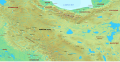
Map of northern Iran under the Sasanians
Shirvan
Iranian intermezzo
-
Map of the Samanid amirate at the death of Nasr II, 943
-
Northern Iran and its surroundings during the Iranian intermezzo
-
Azarbaijan and its surroundings during the Iranian Intermezzo
Post Seljuk era
Safavid Iran
18th century
-
The South Caucasus in the last quarter of the 18th century
-
Political map of the eastern part of the Southern Caucasus between 1795–1801
-
Political map of the Caucasus and its surroundings between 1795–1801
19th-century


 Map of the Parthian Empire under Mithridates II
 Parthian Babylonia and its surroundings

 Map of Sasanian Pars and its surroundings
 Map of Sasanian Khuzistan and its surroundings
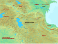 Map of Sasanian Adurbadagan and its surroundings
 Map of Sasanian Asoristan and its surroundings
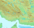 Map of Sasanian Kirman and its surroundings
 Northern Mesopotamia during the late Sasanian era
 Map of Persian Armenia and its surroundings
 The Sasanian Empire at its apex under Khosrow II
 Southeastern part of the Sasanian Empire
 Map of northern Iran under the Sasanians


 Map of the Samanid amirate at the death of Nasr II, 943
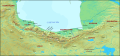 Northern Iran and its surroundings during the Iranian intermezzo
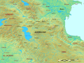 Azarbaijan and its surroundings during the Iranian Intermezzo


 Map of Persian Iraq and its surroundings
 The Administrative Divisions of Safavid Iran in the the South Caucasus
 The South Caucasus in the last quarter of the 18th century
 Political map of the eastern part of the Southern Caucasus between 1795–1801
 Political map of the Caucasus and its surroundings between 1795–1801


 The Erivan Khanate in 1820