| This is not a Wikipedia article: It is an individual user's work-in-progress page, and may be incomplete and/or unreliable. For guidance on developing this draft, see
Wikipedia:So you made a userspace draft. Find sources:
Google (
books ·
news ·
scholar ·
free images ·
WP refs) ·
FENS ·
JSTOR ·
TWL |
The walls of Bologna encircled the city until the beginning of the 20th century, when they were completely demolished to make way for the current ring roads. Built in three successive circles starting in the 3rd century, there are still remnants visible in the historic centre.

Archaic fortifications
It is believed that the walls were first built by the Etruscans for the protection of the city. Archaeological excavations conducted in present-day Piazza Azzarita in 1996 uncovered a palisade from the 8th century BC, running east to west with a covered gallery and upper walkway. The defensive structure was probably equipped with wooden towers and surrounded by three moats. [1]
Most likely the Roman Bononia also had a defensive system consisting of embankments, canals and ditches, including the Aposa river to the east and the Vallescura river to the west (mostly eliminated in the 1st century BC as it was considered a hindrance to urban development). It is presumed that more advanced defensive systems were constructed for the defence of Bononia, but no archaeological evidence of them remains today.
The first ring: the Cerchia di Selenite (ring of selenite)
The oldest wall that still has visible remnants is the so-called "ring of selenite", built after the barbarian invasions at the end of the Western Roman Empire and only discovered in the 1920s. This wall was constructed from blocks of selenite, a very common mineral in the Bologna hills and the so-called "vena del gesso romagnola" (vein of gypsum of Romagna). It was mostly made up of blocks from Roman buildings and measured 7-8 metres in height and 2 metres in depth. [2] The wall had an elongated rectangular shape, presumably with facades on the south west at the site of the Roman theatre (which remained inside), and the north east, up to the Piazetta San Simone. The portion of the city protected by the walls was much smaller than the current historic centre and the Roman city, covering only twenty hectares between via Farini to the south, via Manzoni to the north and via Val d'Àposa to the west, while to the east it followed the course of the Aposa river (parallel to via Oberdan). The poorest neighbourhoods in the north and west of the ancient Roman town were excluded. In the Dark Ages, these remained uninhabited and abandoned, eventually earning the nickname civitas antiqua rupta (rupture of the ancient city).
By the end of the construction of the wall, the city was divided into twelve sections, called horae, by the Byzantines. At every hour of the day and night the inhabitants of the sector on duty were entrusted with the defence of the city. [3]
There have been numerous hypotheses as to when the walls were constructed:
- researcher Angelo Finelli dated it at the beginning of the 5th century; [4] [3]
- historian Albano Sorbelli attributed it to the Lombards after their conquest of the city in 727; [3]
- historian Gina Fasoli hypothesised that it was realised by Theodoric the Great between the end of the 5th and the beginning of the 6th century; [5] [3]
- architect Franco Bergonzoni dated it to the late imperial age (second half of the 3rd century); [6] [3]
- Antonio Ivan Pini attributed it to the Byzantines, between 569 and 727 (perhaps in 641); [7] [3]
- others correlate it with the Hungarian incursions in the 10th century; [3]
- recent studies attest that it was between the end of the 4th and beginning of the 5th century, taking Finelli's observations and reports by the Byzantine historian Zosimus, according to whom Bononia resisted the siege of Alaric I in 402 [8] and thus would most likely have had an efficient defensive system.
Initially there were four gates, arranged along the cardo maximus and decumanus maximus of the city:
- Porta Ravegnana or Porta Ravennate, so named because it was on via San Vitale in the direction of Ravenna
- Porta di San Procolo or Porta Procola
- Porta Stiera or Porta di San Sotero, on via Emilia in the direction of Modena, or according to another hypothesis on via Marsala
- Porta di San Cassiano, later renamed Porta Piera or Porta di San Pietro since it was close to the Cattedrale di San Pietro

Later three more were added:
- Porta Nova di Castiglione
- Porta Nova, probably incorporated into the Lapi Tower
- Porta di Castello, which gave access to the imperial fortress
The blocks of selenite were largely reused for the construction of houses, bases of towers and pillars. Today only a few traces of this old wall remain, one of which is visible in Casa Conoscenti in via Manzoni. Another was discovered in via Rizzoli and yet another in via De' Toschi during the excavations in 1921.
The four crosses

In late antiquity and medieval Bologna many crosses were present, placed on ancient overturned columns and often protected by small chapels, located at the hubs of urban activity, such as crossroads, squares or churches. The oldest appear to have been placed between the end of the 4th and the 5th century just outside the ring of selenite, at the four cardinal points, near four of the city gates. [9] Some historic sources date this to the years 392-393 and legend has it that it was by order of the then bishop of Milan, Saint Ambrose. [9] Another story, perhaps less reliable, says that the construction was instead realised at the end of the 5th century at the behest of the then bishop of Bologna, Saint Petronius. [9] The crosses were redone and replaced several times, and those visible now are all dated between the 12th and 13th centuries, although the columns on which they rest were reused from the Roman era. In the Middle Ages the four crosses were protected by a pyramidal roof, supported by columns with stylophore lions and griffins. They were only removed in 1798 and are today conserved in the Basilica di San Petronio. [9]
Their names are:
- Croce dei Santi Apostoli ed Evangelisti (Cross of the Holy Apostles and Evangelists), from 1159 also known as Croce di Porta Ravegnana (Cross of the Ravenna Gate) and situated in front of where the Two Towers were later erected, the so-called "mercato di mezzo" (central market).
- Croce delle Sante Vergini (Cross of the Holy Virgin), from the 10th century also known as Croce di strada Castiglione (Castiglione Street Cross), or Croce di San Damiano (Saint Damian Cross), or even Croce dei Casali (Cross of the farmhouses), situated to the south-east near the intersection of via Farini and via Castiglione.
- Croce di Tutti i Santi (All Saints Cross), from the 11th century also known as Croce di Porta Procula (Cross of the Procula Gate) or Croce di San Martino (Saint Martin Cross), to the south-west where the ancient Roman theatre was, at the intersection of the current roads via Barberia and via Collegio di Spagna.
- Croce dei Santi Martiri (Cross of the Martyr Saints), from the 11th-12th century also known as Croce di Porta Stiera (Cross of the Stiera Gate) or Croce di Porta Castello (Cross of the Castello Gate), being near both gates, or also Croce dei Santi Fabiano e Sebastiano (Saints Fabian and Sebastian Gate), to the north-west approximately where the ancient Roman commercial Forum was.
The Lombard addition
Probably dating to the 8th century, during the rule of the city by the Lombards, an additional stretch of wall was constructed, called the "addizione longobarda" (Lombard addition), attached to the east side of the first ring and including the Santo Stefano church. The radial development of the present-day roads via Zamboni, via San Vitale, Strada Maggiore, via Santo Stefano and via Castiglione, beginning at the Ravenna Gate, probably meant that the Lombard settlement had a semicircular shape, centred on Piazza di Porta Ravegnana. Traces of this have been preserved in the present-day urban plan, in the streets that curve around the Two Towers on the eastern side (absent on the western side).
The second ring: the Cerchia del Mille (ring of 1000)
,_plastico_di_Bologna.JPG)
The expansion of the city and the birth of new villages outside the walls gave rise to the need to build a new set of walls. Although it was previously thought that they were constructed in the years between 1176 and 1192 (or 1208 according to other sources), corresponding to the conflict with Frederick Barbarossa, recent studies have dated it earlier, reconfirming the ancient name Cerchia del Mille. The semi-destruction of the wall and moats ordered by Barbarossa in 1163 would therefore be attributed, according to this thesis, to this ring and not the ring of selenite.
This second ring was approximately 3.5 km long and had 18 gates, also called serragli ( seraglios) or torresotti (under-towers) as each was topped by a tower, most of which have now been demolished. Four remain today, still visible and incorporated into the town like some remnants of the wall itself, such as those in Piazza Verdi and via Maggia.
The gates often took the names of the streets onto which they opened:
- Serraglio di Strada Maggiore, demolished in 1256
- Pusterla del Borgo di San Petronio (Saint Petronius village postern), also called Pusterla di San Petronio Vecchio (Old Saint Petronius postern) or even Pusterla della Paglia (postern of straw), demolished in the 13th century
- Serraglio di Strada Santo Stefano, also more simply called Serraglio di Santo Stefano (Saint Stephen's Seraglio), demolished in 1256 and with a plaque in its memory at number 38 of the street of the same name
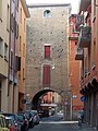
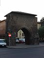
- Torresotto di Castiglione, also called Voltone di Castiglione (Castiglione arch), which is still visible on the street of the same name near Teatro Duse (the Duse Theatre)
- Serraglio di San Procolo, demolished in 1555 and with a plaque in its memory on the street of the same name
- Serraglio o Pusterla di Val d'Aposa, perhaps also called Porta Mariana, which opened on the present-day via Tagliapietre and was demolished in 1570
- Pusterla di Sant'Agnese, demolished in 1488 and with a plaque in its memory in via Bocca di Lupo, near where the gate opened
- Serraglio del Borgo di Saragozza, also more simply called Serraglio di Saragozza, for which there are sources back to the 12th century, demolished in the 16th century
- Serraglio di Berberia, demolished in 1257 and with a plaque in its memory in the street of the same name
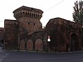
- Serraglio di Porta Nova, also called Voltone di San Francesco (Saint Francis arch) or even Serraglio del Pratello (seraglio of mead), which is still partly visible at the end of the street of the same name on Piazza Malpighi
- Serraglio di Porta Stiera, which opened on present-day via San Felice and via Ugo Bassi, according to some sources demolished in the 14th century, according to others in 1596
- Pusterla del Borgo delle Casse, also called Posterla dei Maggi, which opened near present-day via Maggia and was demolished in 1547, and with a plaque most likely referring to it in via Nazario Sauro
- Serraglio del Poggiale, which opened between via Nazario Sauro and via San Carlo. Today there remain some photographs to attest to its demolition during a bombing in 1943
- Serraglio del Borgo di Galliera, also called Serraglio di Porta Galliera, demolished in 1256
- Serraglio di Porta Govese, also called Voltone di Piella or Torresotto dei Piella, which is still visible between via Piella and via Bertiera
- Serraglio di San Martino dell'Aposa, demolished in 1841
- Serraglio di Strada San Donato, also more simply called Serraglio di San Donato, demolished in 1257 and is most probably the gate that was referred to in several sources relating to a seraglio in Borgo San Giacomo (Saint James village) located near the road giving the gate its name
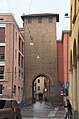
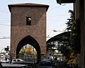
- Serraglio di Strada San Vitale, also called Voltone di San Vitale or Torresotto di San Vitale, which is still visible on the street of the same name where it opens on Piazza Aldrovandi
- Porte della seconda cerchia
-
 Il Torresotto di San Vitale
 -
 Il Torresotto di via Castiglione
 -
 Il Torresotto di Porta Nova
 -
 Il Torresotto di Porta Govese


The third ring: the Circla
_-_Foto_Giovanni_Dall%27Orto,_18-Nov-2007.jpg)
The final ring, with a polygonal shape and called cresta or circla, corresponded to the current ring roads, therefore fully enclosing the Cerchia del Mille. Its construction may be dated to the start of the 13th century, when the city began to organise into neighbourhoods, annexing the suburbs outside. Initially designed in 1226 as a wooden palisade, only in 1327 did the construction begin in stone and it was finished in 1390. The wall was built according to the ancient technique of rubble masonry, where two parallel walls were prepared approximately one metre apart then the space between was filled with a mixture of pebbles, gravel and sand. This architecture is still clearly visible in the parts of the wall still standing as well as the surviving gates.
The third ring stretched for approximately 7.6 km and had twelve gates with drawbridges to cross the outer moat, while inside was a terreplein (also still partly visible) that at some points extended for over 70 metres towards the centre of the city.

The twelve gates were:
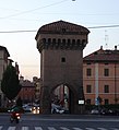
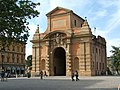
- Porta Maggiore, today also called Porta Mazzini
- Porta Santo Stefano, reconstructed into its current form in 1843
- Porta Castiglione, remodelled in the 15th century
- Porta San Mamolo, demolished in 1903
- Porta Saragozza, reconstructed into its current form between 1845 and 1847
- Porta Sant'Isaia, also called Porta Pia since 1569, demolished in 1903
- Porta San Felice, remodelled in 1508
- Porta delle Lame, reconstructed in 1677
- Porta Galliera, reconstructed between 1659 and 1661
- Porta Mascarella, remodelled in the 16th century
- Porta San Donato, remodelled in the 15th century
- Porta San Vitale, its avant-corps removed in 1952
- Porte della terza cerchia
-
 Porta Maggiore (or Mazzini)
 -
 Porta Castiglione
 -
 Porta Saragozza
 -
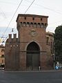 Porta San Felice
 -
 Porta delle Lame
 -
 Porta Galliera
 -
 Porta Mascarella
 -
 Porta San Donato
 -
 Porta San Vitale

.jpg)


_-_Foto_Giovanni_Dall%27Orto,_18-Nov-2007.jpg)


.jpg)

The demolition plan
Between 1902 and 1906, the walls of the third ring were torn down following the council plans made in 1889. Proponents of the plan believed that the walls were limiting the development of the city, referring to the clean sweep that Baron Haussmann made of the centre of medieval Paris on behalf of Napoleon III. However, the medieval city of Bologna was not so strongly affected: perhaps a more fitting model would be Vienna under Emperor Franz Joseph I, where the ring of walls was torn down to make way for the ring roads.
However, the main motivations for supporting the plan were above all social and economic: because of the stalemate in building construction, many masons were unemployed so they warmly supported the proposal to demolish the walls, seeing in it a long-awaited job opportunity. In addition, the municipality could make the large amount of space occupied by the walls, moat and especially the terreplein into buildings, gaining large profits. Today these areas do in fact contain many villas and cottages, constructed at the beginning of the 20th century.
This demolition plan also included the twelve gates but thanks to the intervention of Alfonso Rubbiani and Giosuè Carducci, who defended the historical and artistic importance of the walls, almost all of them were saved except for Porta San Mamolo and Porta Sant'Isaia. The dismantling of Porta Maggiore (originally considered the most important of the gates of Bologna, as the name suggests) was also begun but it was suspended immediately after the discovery of the 13th century gate visible today under the 18th century construction.
The restoration project
Between 2007 and 2009, the surviving gates underwent a restoration that, with the contribution of a credit institution in Bologna, involved personalities from the world of culture and entertainment in the city. [10] While the gates were being restored, images and phrases dedicated to the city from musicians and Bolognese school children were displayed on the temporary works. [11]
These works were the first scientific restorations performed on these monuments. [12] The preliminary analysis identified that there had been six periods of construction and reconstruction. The building phase, realised in the 13th century, was identified in all the gates (with the exception of the frame of Porta Santo Stefano which was reconstructed in the 19th century), characterised by a similar construction of the walls, probably undertaken by a unit of craftsmen. The first significant changes date from the 14th century, with the construction of protective avant-corps for the drawbridges, still preserved on Porta San Donato and Porta Mascarella. Between the 15th and 16th centuries the gates assumed their current form, testified by traces of yellow plaster on the towers and pink on the bodies. The most significant interventions in the following period (18th and 19th centuries) were the restructuring of Porta San Felice and Porta Castiglione and the rebuilding of Porta Santo Stefano from scratch. Portions of wall built with recycled materials and new bricks to support the gates during the demolition of the walls are still visible.
The restoration involved a total of 35 workers and was conducted on all the gates at once. It was divided into four phases: consolidation, cleaning, reintegration and protection.
The most degraded zones were those made of sandstone. The methods adopted for consolidation were diverse: from imbibition with ethyl silicate to localised injection with acrylic or bicomponent resins. At Porta Santo Stefano an experimental method was used, whereby a machine introduced consolidating material by means of a vacuum pump.
Methods for cleaning were also diverse: washing with basic solvent mixtures, micro-sanding using water at controlled pressure, washing with atomised water and the use of vibrating and ultrasonic scalers. During the cleaning phase of Porta Santo Stefano, traces of street signs painted during World War II were discovered, some in German, which had been hidden by graffiti and paint. The reintegration of the walls was achieved using mortar made on-site, opus signinum or marble powder. To safeguard the restorations, protective waterproofing was performed on all the surfaces.
References
- ^ Jacopo Ortalli, Archeologia della prima Felsina: la nascite di una grande città, report of the conference held in Bologna 11 January 2014.
- ^ Cerioli, Francesca; Cornia, Ilaria (2002). Bologna di Selenite. Bologna: Costa Editore. p. 58.
- ^ a b c d e f g Riportato in: Cerioli; Cornia, pp. 59–61
-
^ Finelli, Angelo (1927). Bologna nel Mille. Bologna. pp. 110–113.
{{
cite book}}
: CS1 maint: location missing publisher ( link) -
^ Fasoli, Gina (1960–63). "Momenti di storia urbanistica bolognese nell'alto medioevo". Atti e Memorie della Deputazione di Storia Patria per le Province di Romagna (XII): 313–343.
{{
cite journal}}
: CS1 maint: date format ( link) - ^ Bergonzoni, Franco (2005). "Bononia (189 a.C.- Secolo V)". In Ferri, Antonio; Roversi, Giancarlo (eds.). Storia di Bologna. Bologna: Bononia University press. pp. 67–98.
- ^ Pini, Antonio Ivan (1875). "Bologna bizantina: le mura di selenite o delle "Quattro Croci"". Il Carrobio (XI): 264–277.
- ^ Alarico attaccò le città dell'Emilia, che avevano rifiutato di accettare subito Attalo come imperatore. Senza alcuna difficoltà sottomise tutte le altre ad eccezione di Bononia, che resistette parecchi giorni all'assedio: perciò Alarico, non potendo conquistarla, si recò in Liguria… (Zosimo Storia Nuova, VI, 10.)
- ^ a b c d Croci dei Santi, dei Martiri, degli Apostoli e delle Vergini, sul sito della Direzione Regionale per i Beni Culturali e Paesaggistici dell'Emilia-Romagna.
- ^ restauroportedibologna.it: alcuni video
- ^ restauroportedibologna.it: 8 idee d'amore per Bologna
-
^
http://www.restauroportedibologna.it. Retrieved 9 January 2012.
{{
cite web}}
: Missing or empty|title=( help)
Bibliography
- Roversi, Giancarlo (1985). Le mura perdute. Storia e immagini dell'ultima cerchia fortificata di Bologna. Bologna: Grafis Edizioni.
- G. Sassatelli; A. Donati (2005). Storia di Bologna, Vol. 1 - Bologna nell'antichità. Bologna: Bononia University Press. ISBN 978-88-7395-109-4.
- Ovidio Capitani (2007). Storia di Bologna, Vol. 2 - Bologna nel Medioevo. Bologna: Bononia University Press. ISBN 978-88-7395-208-4.
- Adriano Prosperi (2009). Storia di Bologna, Vol. 3 - Bologna nell'età moderna. Cultura, istituzioni culturali, Chiesa e vita religiosa. Bologna: Bononia University Press. ISBN 978-88-7395-394-4.
See also
External links
- Canè, Paolo (11 June 2007). "Le Mura e le Porte di Bologna". Il Bolognese. Retrieved 5 June 2008.
- "La carta delle pietre". Le Pietre di Bologna: litologia di una città. Regione Emilia-Romagna. Retrieved 7 June 2008.
- Restauro delle porte di Bologna 2007-2009
- Bologna, l'urbanistica e la città dal modello romano a quello medievale, a cura del liceo Minghetti di Bologna
- Marco del Monte. L'epoca d'oro della selenite a Bologna. Il Geologo dell'Emilia-Romagna.
- Evolutio urbis: l'evoluzione del centro storico di Bologna dalla città romana all'ultima cerchia. Mappa indicante i tracciati delle cerchie murarie e dei canali nel loro sviluppo storico.
- Legambiente. "Con Legambiente alla scoperta di Porta Galliera (Video)".