Hudson County, New Jersey in 1898
- vol 9 + 10: commons:Category:1898_Sanborn_Fire_Insurance_Map_from_Hudson_Co.,_Hudson_County,_New_Jersey
Useing Volume 10 to trial different techniques
Summary
| Option | Comments |
|---|---|
| A.1 | |
| A.2 | Same limitations as A.1. |
| A.3 |
|
| A.4 | |
| B |
|
| C | |
| D | Navbox on each Commons file, This requires editing each of the 129 files and each one is different adjacent sheets using the compass directions (North/South/East/West). There are often multiple sheets in each direction. |
| E |
Option A.1
Use {{ Overlay legend}} with a clickable legend.
 1 2 3 4 5 6 | |||||||||||||||
| |||||||||||||||
Option A.2
Similar to A.1, but using a zoomed in view of the Index. Using an image which is croppe view of lower third. This limits the visual scope to allow for easier reading of the labels. Reader more easily sees the page numbers and boundaries with this view.
 1 2 3 4 5 6 7 8 9 10 11 12 13 | |||||||||||||||||||||||||||||
| |||||||||||||||||||||||||||||
Option A.3
Similar look to A.2 without providing any x/y locations. However, the sheet names are not as easy to read since they are in different orientations. This is the easiest to build and maintain since no x/y locations are needed.
Option A.4
Use thumb and list each sheet in the caption.
Option B
Image Labels {{ Image label}} . Need Labelled Image Editor to find the x/y locations.
Look for links to Sheets 1 and 2 toward the bottom. They are difficult to see.
Option C.1
Using the "Gallery" tag
- Packed-overlay
-
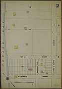
 3
3 -
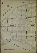
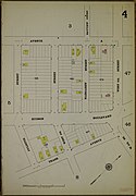 4
4 -
 5
5 -
 8
8 -
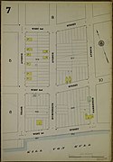 7
7 -
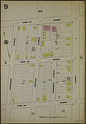 9
9 -
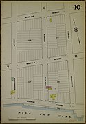 10
10 -
 12
12 -
 11
11 -
 14
14


-
 2
2 -
 6
6
-
 1
1
Option C.2
- No gallery tag, manual padding
![]()


![]()

![]()


![]()

![]()

Option D
Putting a navbox on each page, see Sheet 5 for the sample from Jim H.
| 2 | - | 3 |
| 6 | 5 | 4 |
| - | 7 | 8 |
Option E
Rotate each image to get the same North on the compass:
- 35° clockwise for image 3 ; -40° clockwise for image 4
Background
Color Palette
Sanborn colors:
- grey #8a8279
- mustard #b0aa54
- green #8f9d6c
- rose #9e7372
- mauve (grey) #918786
Label Editor
- Tool Labelled Image Editor in Java
Rotate
- use {{ Transform-rotate}}
<span style="{{Transform-rotate|35}};"> [[File:Sanborn Fire Insurance Map from Hudson Co., Hudson County, New Jersey. LOC sanborn05511 010-4.jpg|90px]] </span> 35° clockwise for image 3
Rounded boxes
use a style with "border-radius: 30px;"