Urvaste Parish
Urvaste vald (in Estonian) Urvastõ vald (in Võro) | |
|---|---|
 Tamme-Lauri oak in
Urvaste | |
 Flag  Coat of arms | |
 Urvaste Parish within Võru County. | |
| Country | Estonia |
| County | Võru County |
| Administrative centre | Kuldre |
| Area | |
| • Total | 139.62 km2 (53.91 sq mi) |
| Population (01.01.2009) | |
| • Total | 1,413 |
| • Density | 10/km2 (26/sq mi) |
| Website | www.urvaste.ee |
Urvaste Parish ( Estonian: Urvaste vald, Võro: Urvastõ vald) was a rural municipality of Estonia, in Võru County. It had a population of 1,413 (as of 1 January 2009) and an area of 139.62 km2. [1]
There are two main tourist attractions: Tamme-Lauri oak and Pokuland ( Estonian: Pokumaa).
Settlements
- Villages
Kassi - Kirikuküla - Koigu - Kõlbi - Kuldre - Lümatu - Pihleni - Ruhingu - Toku - Uhtjärve - Urvaste - Uue-Antsla - Vaabina - Visela
Gallery
-
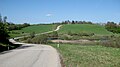 Landscape near Urvaste village.
 -
 Urvaste church
 -
 Pokuland, home of fictional characters Pokus, created by Edgar Valter.
 -

-
 Tamme-Lauri oak, the thickest and oldest tree in Estonia, behind the Estonian 10 kroon banknote.


References
- ^ "Population figure and composition". Statistics Estonia. Retrieved 27 January 2010.
External links
- Official website
- Urvaste blog (in Estonian)
57°53′36″N 26°29′56″E / 57.89333°N 26.49889°E
| Urban municipality | ||
|---|---|---|
| Rural municipalities | ||
|
| This Võru County location article is a stub. You can help Wikipedia by expanding it. |