 Surigae rapidly intensifying near its peak intensity east of the
Philippines on April 17 | |
| Meteorological history | |
|---|---|
| Formed | April 12, 2021 |
| Extratropical | April 25, 2021 |
| Dissipated | May 2, 2021 |
| Violent typhoon | |
| 10-minute sustained ( JMA) | |
| Highest winds | 220 km/h (140 mph) |
| Lowest pressure | 895 hPa ( mbar); 26.43 inHg |
| Category 5-equivalent super typhoon | |
| 1-minute sustained ( SSHWS/ JTWC) | |
| Highest winds | 315 km/h (195 mph) |
| Lowest pressure | 882 hPa ( mbar); 26.05 inHg |
| Overall effects | |
| Fatalities | 10 total |
| Missing | 8 |
| Damage | $10.5 million (2021 USD) |
| Areas affected | Caroline Islands, Palau, Sulawesi, Philippines, Taiwan, Ryukyu Islands, Kuril Islands, Russian Far East, Alaska |
| IBTrACS | |
Part of the 2021 Pacific typhoon season | |
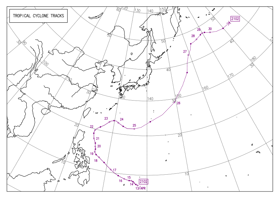
Typhoon Surigae, known in the Philippines as Super Typhoon Bising, was the strongest Northern Hemisphere tropical cyclone to form before the month of May, one of the most intense tropical cyclones on record and the strongest tropical cyclone worldwide in 2021. [1] [2] The second named storm, first typhoon and first super typhoon of the 2021 Pacific typhoon season, Surigae originated from a low-pressure area south of the Micronesian island of Woleai that organized into a tropical depression on April 12. At 18:00 UTC that day, it strengthened to a tropical storm and was named Surigae by the Japan Meteorological Agency (JMA). The formation of an eye and increasing winds prompted the JMA to upgrade the system to a severe tropical storm on April 13. The storm continued to gradually strengthen, and late on April 15, Surigae became a typhoon. Very favorable environmental conditions then allowed Surigae to begin a bout of rapid intensification; Surigae became a super typhoon the next day, and by April 17, the storm reached its peak intensity, with 10-minute sustained winds of 220 km/h (140 mph), [nb 1] 1-minute sustained winds of 315 km/h (196 mph), and a minimum pressure of 895 hPa (26.4 inHg). This made it the strongest pre-May typhoon on record. Afterward, the storm's weakening outflow and an eyewall replacement cycle caused Surigae to gradually weaken as its track shifted north-northwestward in the Philippine Sea. Following the eyewall replacement cycle, Surigae became an annular tropical cyclone on April 19, and restrengthened slightly. On April 22, the storm began to rapidly weaken as it accelerated northwestward into unfavorable environmental conditions, transitioning into a subtropical storm the next day. The subtropical system subsequently underwent extratropical transition, which it completed by April 24. Afterward, Surigae's extratropical remnant accelerated northeastward. On April 27, Surigae's remnant explosively intensified into a bomb cyclone near the Aleutian Islands, attaining hurricane-force winds. Afterward, the system gradually weakened as it turned eastward, slowing down in the process, before crossing the International Date Line on April 30 and fully dissipating on May 2.
Upon Surigae's naming, watches and warnings were issued for the island of Yap in the Federated States of Micronesia and the islands of Koror and Kayangel in Palau as well. The typhoon left US$4.8 million in damage in Palau after cutting off power, water, and destroying infrastructure. [nb 2] Later, warnings were raised for parts of the Philippines as the typhoon moved closer to the nation, with evacuations taking place in eastern regions of the Visayas. The storm killed at least 10 people and left another eight missing, in addition to causing at least ₱272.8 million ( US$5.67 million) in damage in the Philippines.
Meteorological history

Tropical storm (39–73 mph, 63–118 km/h)
Category 1 (74–95 mph, 119–153 km/h)
Category 2 (96–110 mph, 154–177 km/h)
Category 3 (111–129 mph, 178–208 km/h)
Category 4 (130–156 mph, 209–251 km/h)
Category 5 (≥157 mph, ≥252 km/h)
Unknown
During mid-April 2021, an area of atmospheric convection associated with a weak area of low pressure developed roughly 1,150 km (710 mi) south of Guam. By April 10, the disturbance had acquired nascent rainbands within an environment exhibiting low wind shear, warm sea surface temperatures (SSTs) between 28–29 °C (82–84 °F), and a well-established outflow, which was conducive for further tropical cyclogenesis. [4] Showers and thunderstorms continued to emerge around the circulation embedded within the disturbance. [5] The Japan Meteorological Agency (JMA) [nb 3] assessed the formation of a tropical depression near 5°N 143°E / 5°N 143°E; at the time, the newly designated system was moving slowly west-northwest around the southern periphery of a subtropical ridge. [6] [7] Due to its anticipated track into Philippine waters, the Philippine Atmospheric, Geophysical and Astronomical Services Administration (PAGASA) also began issuing advisories on the tropical depression on April 12. [8] The Joint Typhoon Warning Center (JTWC) [nb 4] issued a Tropical Cyclone Formation Alert (TCFA) later that day, projecting a high likelihood of a significant tropical cyclone developing. By April 13, the agency assessed the disturbance as a tropical depression. [10] [11]

A strong rainband along the depression's northern semicircle became prominent and coalesced around a robust and developing central dense overcast. [11] At 18:00 UTC on the same day, the JMA upgraded the system to a tropical storm and named it Surigae. [12] [13] Surigae was also upgraded to a tropical storm by the JTWC in the early hours of April 14, as the system progressed westward in the Philippine Sea. [14] [15] The storm continued to move slowly, remaining nearly stationary on April 14 – as it gradually intensified. [16] [17] Surigae's convective activity was initially displaced to the west of its center of circulation, though additional rainbands and thunderstorm development later covered the central vortex. [18] [19] On April 15, the JMA upgraded Surigae to a severe tropical storm as it moved closer to the island nation of Palau. [20] A formative eye became apparent on microwave satellite imagery later that day. [21]
By April 16, Surigae strengthened to a typhoon just north of Palau, making it the first typhoon of the 2021 Pacific typhoon season. [22] [23] The typhoon's convective activity had become tightly wound around its center, indicating additional strengthening. [24] On April 16 at 03:00 UTC, the Philippine Atmospheric, Geophysical and Astronomical Services Administration (PAGASA) gave the storm the local name Bising as it entered the Philippine Area of Responsibility. [25] The system's eye became apparent through the central overcast, preceding a period of rapid intensification as Surigae progressed west-northwestward through a conducive environment. [26] [27] [28] Surigae's central dense overcast became colder and better-organized, with a well-defined ring of very cold cloud tops encircling a 26 km (16 mi) diameter eye. [29] Concurrently, an approaching trough produced a gap in the subtropical ridge of high pressure to the north, causing Surigae to slowly curve northwest as it quickly strengthened. [30]

On April 17, the JMA determined that Surigae's barometric pressure had rapidly fallen to 895 hPa ( mbar; 26.43 inHg), as the storm reached its peak intensity. [31] [32] Its 10-minute maximum sustained winds reached 220 km/h (135 mph) according to the JMA, while one-minute maximum sustained winds reached 315 km/h (195 mph) according to the JTWC, making it equivalent to a Category 5 super typhoon on the Saffir–Simpson scale (SSHWS); [nb 5] [34] [35] the peak 1-minute sustained winds were also higher for the time of year than any previous typhoon on record. [31] The JTWC also estimated a minimum central pressure of 882 hPa (mbar; 26.05 inHg) for Surigae at the time. [36] Later that day, Surigae began an eyewall replacement cycle causing its eye to become less apparent on satellite imagery and its winds to slightly diminish. The trough to Surigae's north also impeded the typhoon's outflow, resulting in a decrease in environmental favorability for further intensification. [37] [38] On April 18, Surigae finished its eyewall replacement cycle; [38] Surigae acquired annular characteristics, bearing a symmetrical appearance and a large eye, which was largely surrounded by one large rainband, by the next day. [36]
By April 20, the prevalence of nearby dry air and upwelling of cold waters beneath the slow-moving typhoon caused its winds to decrease further. [39] [40] Some reorganization occurred when Surigae began to move north and away from the upwelled waters, with its large eye becoming less ragged; [39] however, additional entrainment of dry air originating from the mid-troposphere over Luzon caused Surigae's structure to degrade further on April 21. [41] Surigae turned northeast away from the Philippines later that day and weakened further, upon entering an environment with strong westerly winds in the upper troposphere. [42] [43] The once large and clear eye disappeared on April 22, leaving behind an increasingly-disheveled cluster of weakening showers and thunderstorms. [44] Soon afterward, all of Surigae's remaining convection was sheared to the east, as the storm moved over cooler waters. [45] As most of the remaining thunderstorms had dissipated, Surigae transitioned into a subtropical cyclone on April 23 due to interacting with an upper-level atmospheric trough as Surigae traversed a cold oceanic eddy. [46] Surigae began to undergo extratropical transition, a process it completed late on April 24, at which time the JTWC issued their final advisory on the system. [47] The JMA declared that Surigae had become extratropical a few hours later. [48]
As an extratropical cyclone, Surigae underwent explosive cyclogenesis on April 26, with its central pressure falling 44 hPa (mbar; 1.3 inHg) within 24 hours, while rapidly tracking northeastward. [49] While located to the east of Hokkaido, the system's ten-minute maximum sustained winds reached 130 km/h (80 mph) at 18:00 UTC that day, [50] and its central pressure bottomed out at 944 hPa (mbar; 27.88 inHg) six hours later. [51] Late on April 27, Surigae's remnant started to weaken while turning eastward. The next day, the system's forward motion significantly slowed down. On April 30, Surigae underwent a center reformation, with the original center of low pressure dissipating, and a new low-pressure center forming shortly afterward, which quickly dominated the system. [52] Afterward, Surigae's remnant continued moving eastward while gradually weakening, turning northeastward on May 1. On May 2, Surigae's remnant was absorbed into another extratropical cyclone, just south of the Alaskan Panhandle.
Preparations
.jpg)
Due to the threat of the storm, a Tropical Storm Watch was issued for the island of Yap and Ngulu Atoll as well as for Koror and Kayangel in Palau on April 14, [53] where in the former, winds exceeded 30 mph (48 km/h). [54] The watch was upgraded to a Tropical Storm Warning for Ngulu Atoll later that day. [55]
As Surigae entered the Philippine Area of Responsibility, the PAGASA began issuing weather bulletins for the nearby storm. Initial forecasts by the agency suggested that the storm was less likely to make landfall over Luzon, and expected the storm to re-curve away from the Philippines. [25] [56] [57] On April 16, the Department of Transportation of the Philippines suspended all air and land travel to and from Visayas and Mindanao. [58] In the ensuing travel suspension, 2,507 individuals and 61 sea vessels were stranded in ports throughout the country. [59] Wave heights as high as 4.5 m (15 ft) were forecast near the eastern coasts of Visayas and Mindanao. [60] In order to avoid agricultural losses, Secretary William Dar of the Department of Agriculture encouraged farmers in the Bicol and Eastern Visayas regions to harvest their crops and for fishermen to refrain from fishing due to worsening oceanic conditions. [57] [61] At 15:00 UTC (23:00 PHT), the PAGASA began issuing Tropical Cyclone Wind Signal (TCWS) #1 for areas in Eastern Visayas and the Caraga Region, as well as for portions of Luzon six hours later. [62] [63]
On April 17, TCWS #2 was issued for Catanduanes and the entire island of Samar. [64] Flood advisories were also issued by the PAGASA for three regions in Visayas and Mindanao. [65] In preparation for the intense rains, the National Telecommunications Commission ordered telecommunications companies to prepare facilities in forecasted affected areas, including free calling and charging stations. [66] [67] [68] As early as April 17, preemptive evacuation began in the Bicol Region and the Samar province, [69] and by April 21, 169,072 people were evacuated in the Cagayan Valley, Bicol Region, Eastern Visayas, and Caraga. Flights in Daniel Z. Romualdez Airport and all Tacloban Airports were cancelled on April 18, and other domestic flights were also cancelled on the same day. [67] In addition, 10 domestic flights elsewhere were also cancelled that day. [59] Schools and work activities were suspended in the Bicol Region till April 20. [70] ₱1.5 billion ( US$31.05 million) worth of standby funds were prepared for disaster response. [71]
Impact
Micronesia and Palau
Locally heavy rainfall occurred in parts of Palau and Yap for several days. [72] Surigae brought sustained winds of up to 80 km/h (50 mph) and gusts up to 135 km/h (84 mph) to Palau, causing power outages across the island. [73] [74] [75] Large swells from the developing storm brought coastal flooding to Koror and Yap. Residents in those areas were advised to avoid reef lines in the north and west, and to take caution on beaches due to rip currents and large waves. [76] Surigae was the closest typhoon to pass near the island of Palau since Typhoon Haiyan. [77] Restaurants, sporting events and other services were closed in Palau as Surigae approached closer– yet schools remained open. [77] Schools were not suspended until power had been cut off across much of the entire country. [77] Water and cellular services were also downed. [77] There was criticism for the lack of news coverage on the typhoon in Palau most notably. [77] 125 homes across the country were destroyed, while at least 1,500 sustained minor damage. [75] The entire population of Palau, consisting of approximately 18,008 people, was impacted by the typhoon. [75] At least US$2 million worth of infrastructure alone was damaged in Palau. [78] The total amount of damage across health, infrastructure, education, food, communication, utilities and other sectors was assessed at US$4.8 million. [75] President of Palau Surangel Whipps Jr. issued a national state of emergency on April 18. [79] The United States Agency for International Development (USAID) provided US$100,000 for immediate assistance to support those affected. [80] In Guam, emergency supplies were being prepared and donated to communities in need in Palau. [79]
Philippines

Five people in a boat were rescued off the coast of Pujada Bay due to dangerous sea conditions produced by Surigae. [81] Another boat with two fishermen aboard capsized during midnight on its way to Bantayan Island, with both of two fishermen having to swim back to shore. [82] On April 19, Surigae forced the cargo ship LCU Cebu Great Ocean, carrying twenty crew members and nickel ore, to run aground on the coast of the Province of Surigao del Norte, in the southern Philippines. [83] [84] At least six of the crew members were found dead, while seven were rescued; the search continues for another missing seven crew members. [85] [86] Heavy rain from the outer bands of Surigae battered Eastern Visayas and the Bicol Region as it passed around 345 km (214 mi) to the east of Catanduanes. [87] Widespread rainfall totals of up to 8–12 inches (200–300 mm) occurred in the eastern Philippines, while 20.13 inches (511 mm) of rain fell in Virac, Catanduanes and surrounding areas. [88] A funnel cloud was also briefly reported in Camarines Sur. [89] Twenty-two barangays were flooded in Eastern Visayas, and in the municipality of Jipapad, flooding reached 4 metres (13 ft). Power interruptions were experienced in Central Visayas, Eastern Visayas and in Eastern Samar, power was interrupted for the whole province. [67] 109,815 people were displaced by flooding and landslides in the Bicol Region. [90]
Ten deaths were reported due to the typhoon. One person in Southern Leyte and another in Cebu died due to fallen coconut trees. [91] [92] Six crew members of the LCU Cebu Great Ocean were found dead after the ship ran aground in the southern Philippines; another seven crew members remain missing. [85] [86] Another person remains missing in Northern Samar. [93] 13 others were injured. [91] A total of 3,385 houses were damaged in the Bicol Region, Eastern Visayas and Caraga, with 158 totally destroyed. Agricultural damage in the Bicol Region and Eastern Visayas reached ₱261.9 million ( US$5.43 million), while infrastructural damage totaled ₱10.87 million (US$226,000). [94] 63 cities experienced power interruptions; however, power was restored in 54 of those cities. [95]
Following the passage of Surigae, the Department of Social Welfare and Development (DSWD) and local government units provided assistance worth approximately ₱6.52 million (US$135,000) to those affected in Cagayan Valley, the Bicol Region and the Eastern Visayas. [94] Schools and workplaces fully reopened by April 20. [96]
Elsewhere
The influence of Surigae caused gusts in North Sulawesi that reached 23 mph (37 km/h). [97] Large waves of 13.1–19.8 feet (4.0–6.0 m) affected the coastal waters of the Sitaro Islands Regency, Sangihe Islands Regency, the Talaud Islands and the northern Molucca Sea. [98] Surigae made its closest approach to Taiwan on April 22. The typhoon's outer bands brought much-needed rainfall to central Taiwan, which was going through its worst drought in 56 years. There were also reports of hail. [99] Large waves up to 4.2 m (14 ft) tall generated by Surigae were recorded along Taiwan's east coast on April 21. [100]
See also
- Weather of 2021
- Tropical cyclones in 2021
- Other tropical cyclones named Bising
- Typhoon Marie (1976) – took a similar track, impacted Palau and Eastern Philippines
- Typhoon Roy (1988) – the second-most intense January tropical cyclone on record in the Western Pacific basin
- Typhoon Mitag (2002) – another strong early-season typhoon that took a somewhat similar path.
- Typhoon Songda (2011) – took a similar track and went on to impact Japan
- Typhoon Maysak (2015) – the most powerful typhoon in the basin to form before April, affected similar areas.
- Typhoon Wutip (2019) – strongest February typhoon on record
- Typhoon Goni (2020) – a super typhoon affected Philippines after 6 months later.
- Typhoon Mawar (2023) – strongest May typhoon on record
Notes
- ^ The Japan Meteorological Agency uses 10-minute sustained winds, while the Joint Typhoon Warning Center uses 1-minute sustained winds. The conversion factor between the two is 1.14. [3]
- ^ All monetary figures are in their 2021 values unless otherwise noted.
- ^ The Japan Meteorological Agency is the official Regional Specialized Meteorological Center for the western Pacific Ocean.
- ^ The Joint Typhoon Warning Center is a joint United States Navy – United States Air Force task force that issues tropical cyclone warnings for the western Pacific Ocean and other regions. [9]
- ^ A super typhoon is an unofficial category used by the Joint Typhoon Warning Center (JTWC) for a typhoon with winds of at least 240 km/h (150 mph). [33]
References
- ^ "Rare Super Typhoon Surigae Barrels Towards the Philippines; Intensifies at Record Pace". The Weather Channel. Archived from the original on 2021-04-18. Retrieved April 18, 2021.
- ^ Samenow, Jason; Cappucci, Matthew. "Surigae sweeps past Philippines, after becoming strongest April typhoon on record". Washington Post. ISSN 0190-8286. Archived from the original on April 16, 2021. Retrieved April 18, 2021.
- ^ Joint Typhoon Warning Center (2005). "Frequently Asked Questions". Archived from the original on September 1, 2013. Retrieved July 23, 2006.
- ^ Significant Tropical Weather Advisory for the Western and South Pacific Oceans Reissued 101330Z-110600Z April 2021 (Report). Pearl Harbor, Hawaii: Joint Typhoon Warning Center. April 10, 2021.
- ^ Significant Tropical Weather Advisory for the Western and South Pacific Oceans Reissued 111430Z-120600Z April 2021 (Report). Pearl Harbor, Hawaii: Joint Typhoon Warning Center. April 11, 2021.
- ^ Warning and Summary 120600 (Report). Tokyo, Japan: Japan Meteorological Agency. April 12, 2021. Archived from the original on April 14, 2021. Retrieved April 14, 2021 – via Iowa Environmental Mesonet.
- ^ Reasoning No. 1 for TD Located at 7.1N 139.9E (RSMC Tropical Cyclone Prognostic Reasoning). Tokyo, Japan: Japan Meteorological Agency. April 13, 2021. Archived from the original on April 14, 2021.
- ^ "Tropical Cyclone Advisory #1" (PDF). Manila, Philippines: Philippine Atmospheric, Geophysical and Astronomical Services Administration. April 12, 2021. Archived from the original (PDF) on April 13, 2021. Retrieved April 13, 2021.
- ^ "Joint Typhoon Warning Center Mission Statement". Joint Typhoon Warning Center. 2011. Archived from the original on July 26, 2007. Retrieved July 25, 2012.
- ^ Tropical Cyclone Formation Alert (121121Z April 2021) (Report). Pearl Harbor, Hawaii: Joint Typhoon Warning Center. April 12, 2021. Archived from the original on April 14, 2021. Retrieved April 14, 2021 – via Iowa Environmental Mesonet.
- ^ a b Prognostic Reasoning for Tropical Depression 02W (Two) Warning NR 001 (TXT) (Report). Pearl Harbor, Hawaii: Joint Typhoon Warning Center. April 13, 2021. Archived from the original on April 19, 2021. Retrieved April 19, 2021 – via Iowa Environmental Mesonet.
- ^ Warning 131800 (Report). Tokyo, Japan: Japan Meteorological Agency. April 13, 2021. Archived from the original on April 14, 2021.
- ^ Reasoning No. 4 for TS 2102 Surigae (RSMC Tropical Cyclone Prognostic Reasoning). Tokyo, Japan: Japan Meteorological Agency. April 13, 2021. Archived from the original on April 14, 2021.
- ^ Tropical Depression 02W (Two) Warning No. 1 (Report). United States Joint Typhoon Warning Center. 14 April 2021. Archived from the original on 2021-04-13. Retrieved 14 April 2021. Alt URL
- ^ Prognostic Reasoning for Tropical Storm 02W (Surigae) Warning No. 3 (Report). United States Joint Typhoon Warning Center. 14 April 2021. Archived from the original on 2021-04-14. Retrieved 14 April 2021. Alt URL
- ^ TS 2102 Surigae (2102) Advisory 140600 (RSMC Tropical Cyclone Advisory). Tokyo, Japan: Japan Meteorological Agency. April 14, 2021. Archived from the original (TXT) on April 15, 2021. Retrieved April 15, 2021.
- ^ TS 2102 Surigae (2102) Advisory 142100 (RSMC Tropical Cyclone Advisory). Tokyo, Japan: Japan Meteorological Agency. April 14, 2021. Archived from the original (TXT) on April 15, 2021. Retrieved April 15, 2021.
- ^ Prognostic Reasoning for Tropical Storm 02W (Surigae) Warning NR 003 (TXT) (Report). Pearl Harbor, Hawaii: Joint Typhoon Warning Center. April 14, 2021. Archived from the original on April 19, 2021. Retrieved April 19, 2021 – via Iowa Environmental Mesonet.
- ^ Prognostic Reasoning for Tropical Storm 02W (Surigae) Warning NR 005 (TXT) (Report). Pearl Harbor, Hawaii: Joint Typhoon Warning Center. April 14, 2021. Archived from the original on April 19, 2021. Retrieved April 19, 2021 – via Iowa Environmental Mesonet.
- ^ Warning 150000 (Report). Tokyo, Japan: Japan Meteorological Agency. April 15, 2021. Archived from the original on April 15, 2021.
- ^ Prognostic Reasoning for Tropical Storm 02W (Surigae) Warning NR 009 (TXT) (Report). Pearl Harbor, Hawaii: Joint Typhoon Warning Center. April 15, 2021. Retrieved April 15, 2021 – via Iowa Environmental Mesonet.
- ^ Warning 160000 (Report). Tokyo, Japan: Japan Meteorological Agency. April 13, 2021. Archived from the original on April 16, 2021.
- ^ Erdman, Jonathan (April 16, 2021). "Typhoon Surigae Rapidly Intensifies, Potential Philippines Danger Beginning This Weekend". TWC Product and Technology. Archived from the original on April 16, 2021. Retrieved April 16, 2021.
- ^ Prognostic Reasoning for Typhoon 02W (Surigae) Warning NR 011 (TXT) (Report). Pearl Harbor, Hawaii: Joint Typhoon Warning Center. April 16, 2021. Archived from the original on April 19, 2021. Retrieved April 19, 2021 – via Iowa Environmental Mesonet.
- ^ a b "Severe Weather Bulleting #1 for Typhoon "Bising" (Surigae)" (PDF). Philippine Atmospheric, Geophysical and Astronomical Services Administration. April 16, 2021. Archived (PDF) from the original on April 16, 2021. Retrieved April 16, 2021.
- ^ Prognostic Reasoning for Typhoon 02W (Surigae) Warning NR 013 (TXT) (Report). Pearl Harbor, Hawaii: Joint Typhoon Warning Center. April 16, 2021. Archived from the original on April 19, 2021. Retrieved April 19, 2021 – via Iowa Environmental Mesonet.
- ^ "Typhoon 02W (Surigae) Warning NR 013". Joint Typhoon Warning Center. April 16, 2021. Archived from the original on April 16, 2021. Retrieved April 16, 2021.
- ^ Prognostic Reasoning for Typhoon 02W (Surigae) Warning NR 014 (TXT) (Report). Pearl Harbor, Hawaii: Joint Typhoon Warning Center. April 16, 2021. Archived from the original on April 19, 2021. Retrieved April 16, 2021 – via Iowa Environmental Mesonet.
- ^ Prognostic Reasoning for Typhoon 02W (Surigae) Warning NR 016 (TXT) (Report). Pearl Harbor, Hawaii: Joint Typhoon Warning Center. April 17, 2021. Archived from the original on April 19, 2021. Retrieved April 19, 2021 – via Iowa Environmental Mesonet.
- ^ Prognostic Reasoning for Typhoon 02W (Surigae) Warning NR 015 (TXT) (Report). Pearl Harbor, Hawaii: Joint Typhoon Warning Center. April 17, 2021. Archived from the original on April 19, 2021. Retrieved April 19, 2021 – via Iowa Environmental Mesonet.
- ^ a b Masters, Jeff (April 17, 2021). "Category 5 Super Typhoon Surigae brushes Philippines". Eye on the Storm. Yale Climate Connections. Archived from the original on April 18, 2021. Retrieved April 18, 2021.
- ^ "Surigae Stirs Up the Pacific". Earth Observatory. NASA. April 19, 2021. Archived from the original on April 22, 2021. Retrieved April 22, 2021.
- ^ Frequently Asked Questions (Report). Joint Typhoon Warning Center. August 13, 2012. Archived from the original on October 4, 2013. Retrieved September 22, 2012.
- ^ Cappucci, Matthew; Samenow, Jason (April 17, 2021). "Super Typhoon Surigae to pass near Philippines at Category 5 strength Sunday". The Washington Post. Washington, D.C. Archived from the original on April 16, 2021. Retrieved April 17, 2021.
- ^ Reasoning No. 20 for TY 2102 Surigae (RSMC Tropical Cyclone Prognostic Reasoning). Tokyo, Japan: Japan Meteorological Agency. April 17, 2021. Archived from the original on April 18, 2021.
- ^ a b Cappucci, Matthew (April 19, 2021). "Typhoon Surigae intensified with surprising speed, bearing the fingerprint of climate change". The Washington Post. Archived from the original on May 9, 2021. Retrieved April 20, 2020.
- ^ Prognostic Reasoning for Typhoon 02W (Surigae) Warning NR 019 (TXT) (Report). Pearl Harbor, Hawaii: Joint Typhoon Warning Center. April 18, 2021. Archived from the original on April 19, 2021. Retrieved April 19, 2021 – via Iowa Environmental Mesonet.
- ^ a b Prognostic Reasoning for Typhoon 02W (Surigae) Warning NR 020 (TXT) (Report). Pearl Harbor, Hawaii: Joint Typhoon Warning Center. April 18, 2021. Archived from the original on April 19, 2021. Retrieved April 19, 2021 – via Iowa Environmental Mesonet.
- ^ a b Reasoning No. 29 for TY 2102 Surigae (RSMC Tropical Cyclone Prognostic Reasoning). Tokyo, Japan: Japan Meteorological Agency. April 20, 2021. Archived from the original on April 22, 2021.
- ^ Prognostic Reasoning for Typhoon 02W (Surigae) Warning NR 029 (TXT) (Report). Pearl Harbor, Hawaii: Joint Typhoon Warning Center. April 20, 2021. Archived from the original on April 22, 2021. Retrieved April 22, 2021 – via Iowa Environmental Mesonet.
- ^ Prognostic Reasoning for Typhoon 02W (Surigae) Warning NR 032 (TXT) (Report). Pearl Harbor, Hawaii: Joint Typhoon Warning Center. April 21, 2021. Archived from the original on April 22, 2021. Retrieved April 22, 2021 – via Iowa Environmental Mesonet.
- ^ Prognostic Reasoning for Typhoon 02W (Surigae) Warning NR 034 (TXT) (Report). Pearl Harbor, Hawaii: Joint Typhoon Warning Center. April 21, 2021. Archived from the original on April 22, 2021. Retrieved April 22, 2021 – via Iowa Environmental Mesonet.
- ^ Prognostic Reasoning for Typhoon 02W (Surigae) Warning NR 035 (Report). Pearl Harbor, Hawaii: Joint Typhoon Warning Center. April 22, 2021.
- ^ Prognostic Reasoning for Typhoon 02W (Surigae) Warning NR 037 (Report). Pearl Harbor, Hawaii: Joint Typhoon Warning Center. April 22, 2021.
- ^ "PROGNOSTIC REASONING FOR TROPICAL STORM 02W (SURIGAE) WARNING NR 041". Pearl Harbor, Hawaii: Joint Typhoon Warning Center. April 23, 2021. Archived from the original on April 23, 2021. Retrieved April 23, 2021.
- ^ "Prognostic Reasoning for Subtropical Storm 02W (Surigae) No 42". Joint Typhoon Warning Center. April 23, 2021. Archived from the original on April 17, 2021.
- ^ "SUBTROPICAL STORM 02W (SURIGAE) WARNING NR 046". Archived from the original on April 25, 2021.
- ^ "WTPQ50 RJTD 250000". Japan Meteorological Agency. April 25, 2021. Archived from the original on April 25, 2021. Retrieved April 27, 2021.
- ^ "WWJP27 RJTD 260000". Japan Meteorological Agency. April 26, 2021. Archived from the original on April 27, 2021. Retrieved April 27, 2021.
- ^ "WWJP27 RJTD 261800". Japan Meteorological Agency. April 26, 2021. Archived from the original on April 27, 2021. Retrieved April 27, 2021.
- ^ "WWJP27 RJTD 270000". Japan Meteorological Agency. April 26, 2021. Archived from the original on April 27, 2021. Retrieved April 27, 2021.
- ^ "WWJP27 RJTD 301200". Japan Meteorological Agency. April 30, 2021. Archived from the original on May 1, 2021. Retrieved April 30, 2021.
- ^ "Tropical storm watch in effect for Yap and Ngulu in Yap State". KUAM News. April 14, 2021. Archived from the original on April 14, 2021. Retrieved April 14, 2021.
- ^ Matthew Cappucci (April 14, 2021). "Tropical Storm Surigae to intensify into powerful Pacific typhoon, brush past Philippines". The Washington Post. Archived from the original on December 22, 2021. Retrieved April 14, 2021.
- ^ "Tropical Depression Surigae (02W) Advisory Number 2". National Weather Service Office in Tiyan, Guam. April 15, 2021. Archived from the original on April 15, 2021. Retrieved April 15, 2021.
- ^ De Vera-Ruiz, Ellalyn (April 16, 2021). "'Bising' now a typhoon, Signal No. 1 seen over parts of Northern, Eastern Samar as early as Friday evening – PAGASA". Manila Bulletin. Archived from the original on April 16, 2021. Retrieved April 16, 2021.
- ^ a b Unite, Betheena (April 16, 2021). "Better safe than sorry: DA urges farmers to prepare for 'Bising'". Manila Bulletin. Archived from the original on April 16, 2021. Retrieved April 16, 2021.
- ^ "Land, sea travel to Visayas and Mindanao suspended due 'Typhoon Bising'". pia.gov.ph. April 16, 2021. Archived from the original on April 16, 2021. Retrieved April 16, 2021.
- ^ a b "SitRep no. 06 re Preparedness Measures and Effects for Typhoon Bising" (PDF). ndrrmc.gov.ph. April 21, 2021. Archived (PDF) from the original on April 21, 2021. Retrieved April 21, 2021.
- ^ Villamor-Ilano, Marites (April 16, 2021). "Typhoon Bising threatens Northern Samar, Eastern Samar". Sunstar. Archived from the original on April 16, 2021. Retrieved April 16, 2021.
- ^ Cudis, Christine. "Farmers, fisherfolk in 'Bising' path warned to guard livelihood". www.pna.gov.ph. Archived from the original on April 16, 2021. Retrieved April 16, 2021.
- ^ "Severe Weather Bulletin #2 for Typhoon 'Bising' (Surigae)" (PDF). PAGASA. 16 April 2021. Retrieved 16 April 2021.[ dead link] Alt URL
- ^ "Severe Weather Bulletin #3 for Typhoon 'Bising' (Surigae)" (PDF). PAGASA. 16 April 2021. Retrieved 16 April 2021.[ dead link] Alt URL
- ^ "Severe Weather Bulletin #5 for Typhoon 'Bising' (Surigae)" (PDF). PAGASA. 17 April 2021. Retrieved 17 April 2021.[ dead link] Alt URL
- ^ General Flood Advisory #1 for Region 5 (Bicol Region), Region 8 (Eastern Visayas), Region 13 (Caraga), PAGASA, April 17, 2021, archived from the original on April 17, 2021, retrieved April 17, 2021 Alt URL
- ^ Quevedo, Richbon G. (April 17, 2021). "NTC to telcos: Provide sufficient service during typhoon Bising". INQUIRER.net. Archived from the original on April 17, 2021. Retrieved April 17, 2021.
- ^ a b c "SitRep no. 04 re Preparedness Measures and Effects for Typhoon BISING" (PDF). ndrrmc.gov.ph. April 19, 2021. Archived (PDF) from the original on April 19, 2021. Retrieved April 19, 2021.
- ^ Arguelles, Mar S. (April 17, 2021). "340 persons evacuated in Camarines Sur as Typhoon Bising draws nearer". INQUIRER.net. Archived from the original on April 17, 2021. Retrieved April 17, 2021.
- ^ Bordey, Hana. "Pre-emptive evacuation on-going in Bicol, Samar as Bising intensifies". GMA News Online. Archived from the original on April 17, 2021. Retrieved April 17, 2021.
- ^ Connie Calipay; Mar Serrano. "Classes, work suspended in Bicol due to 'Bising'". www.pna.gov.ph. Philippine News Agency. Archived from the original on April 20, 2021. Retrieved April 20, 2021.
- ^ Christine Cudis. "DSWD emergency fund, food boxes on standby for 'Bising' victims". www.pna.gov.ph. Philippine News agency. Archived from the original on April 20, 2021. Retrieved April 20, 2021.
- ^ "NWS monitoring tropical storm near Yap, Palau". The Guam Daily Post. April 14, 2021. Archived from the original on April 14, 2021. Retrieved April 14, 2021.
- ^ Lorenzo Badellino (April 15, 2021). "METEO. La tempesta Surigae si avvicina alle Filippine. Imminente il passaggio a ciclone tropicale" (in Italian). 3Bmeteo. Archived from the original on April 16, 2021. Retrieved April 16, 2021.
- ^ Robert Speta [@RobertSpetaWX] (April 15, 2021). "Kauai Okada just shared these photos from Palau. She says the island is without power right now with downed trees across the island. Winds have also been reported gusting over 50kts or 90kph on the island" ( Tweet). Retrieved April 16, 2021 – via Twitter.
- ^ a b c d "Republic of Palau: Typhoon Surigae - Emergency Plan of Action (EPoA), DREF Operation n° 1 MDRPW001" (PDF). ReliefWeb. International Federation of Red Cross and Red Crescent Societies (IFRC/ICRC). April 26, 2021. Archived (PDF) from the original on April 28, 2021. Retrieved April 27, 2021.
- ^ Chan (April 14, 2021). "Coastal Flood Warnings/Watches/Statements". National Weather Service Tiyan, Guam. Archived from the original on April 14, 2021. Retrieved April 14, 2021.
- ^ a b c d e "The typhoon that hit my island didn't make the news. This is what the climate crisis looks like". the Guardian. April 23, 2021. Archived from the original on April 23, 2021. Retrieved April 24, 2021.
- ^ "Palau assesses Typhoon Surigae aftermath, estimates $2 million in damage". Marianas Variety News & Views. Archived from the original on April 24, 2021. Retrieved April 24, 2021.
- ^ a b "Coast Guard Cutter delivers emergency supplies to Palau following Typhoon Surigae". DVIDS. Archived from the original on April 29, 2021. Retrieved April 27, 2021.
- ^ "United States Providing Humanitarian Assistance in Response to Damaging Typhoon Surigae in Palau | Press Release | U.S. Agency for International Development". www.usaid.gov. April 21, 2021. Archived from the original on April 24, 2021. Retrieved April 24, 2021.
- ^ Llemit, Ralph Lawrence G. (April 18, 2021). "5 rescued from sinking boat". Sunstar. Archived from the original on April 19, 2021. Retrieved April 18, 2021.
- ^ Palaubsanon, Mitchelle L. "More Cebu LGUs placed under Signal No. 1 Sunday". Philstar.com. Archived from the original on April 18, 2021. Retrieved April 18, 2021.
- ^ Mikhail Voytenko (April 20, 2021). "Two ships fell victim to typhoon rage, 20 crew missing, Philippines". FleetMon. Retrieved April 21, 2021.[ permanent dead link]
- ^ "Cargo ship runs aground as storm strikes near Philippines". Reuters. April 20, 2021. Archived from the original on April 21, 2021. Retrieved April 21, 2021.
- ^ a b "PCG: 2 more crewmen of ill-fated cargo ship found dead, 7 still missing". Manila Bulletin. April 25, 2021. Archived from the original on April 25, 2021. Retrieved April 25, 2021.
- ^ a b Karen Lema (April 21, 2021). "Four crew dead, 9 missing after cargo ship runs aground in Philippines". Yahoo! News. Archived from the original on April 21, 2021. Retrieved April 21, 2021.
- ^ "Rain from Typhoon Bising hits Eastern Visayas, Bicol". Rappler. 18 April 2021. Archived from the original on April 18, 2021. Retrieved April 18, 2021.
- ^ "Deadly Typhoon Surigae leaves flooding, damage behind in the Philippines". news.yahoo.com. Archived from the original on April 24, 2021. Retrieved April 24, 2021.
- ^ "Funnel cloud leaves Bicolanos in awe, others in fear". Manila Bulletin. April 18, 2021. Archived from the original on April 18, 2021. Retrieved April 18, 2021.
- ^ "Landslides, flooding from Bising displace over 109,000 in Bicol". Rappler. 19 April 2021. Archived from the original on April 20, 2021. Retrieved April 20, 2021.
- ^ a b "SitRep no. 09 re Preparedness Measures and Effects for Typhoon BISING" (PDF). ndrrmc.gov.ph. April 24, 2021. Archived (PDF) from the original on April 24, 2021. Retrieved April 24, 2021.
- ^ "Two dead, over 18,000 families evacuated due to Typhoon Bising". cnn. Archived from the original on April 19, 2021. Retrieved April 19, 2021.
- ^ "One dead, one missing as 'Bising' batters Eastern Visayas". Manila Bulletin. April 19, 2021. Archived from the original on April 19, 2021. Retrieved April 19, 2021.
- ^ a b "SitRep no. 16 re Preparedness Measures and Effects for Typhoon Bising" (PDF). ndrrmc.gov.ph. May 12, 2021. Archived (PDF) from the original on May 26, 2021. Retrieved May 26, 2021.
- ^ "SitRep no. 07 re Preparedness Measures and Effects for Typhoon Bising" (PDF). ndrrmc.gov.ph. April 22, 2021. Archived (PDF) from the original on April 22, 2021. Retrieved April 22, 2021.
- ^ "SitRep no. 13 re Preparedness Measures and Effects for Typhoon Bising" (PDF). ndrrmc.gov.ph. May 1, 2021. Archived (PDF) from the original on May 1, 2021. Retrieved May 1, 2021.
- ^ Ellyvon Pranita (April 14, 2021). "BMKG: Awas Siklon Tropis Surigae Bisa Berkembang Jadi Badai Topan". Kompas (in Indonesian). Archived from the original on April 14, 2021. Retrieved April 14, 2021.
- ^ "BMKG Peringatkan Ancaman Siklon Tropis Surigae". Koran Jakarta (in Indonesian). April 14, 2021. Archived from the original on April 14, 2021. Retrieved April 14, 2021.
- ^ Everington, Keoni (April 23, 2021). "Video shows heavy rainfall in parched central Taiwan". Taiwan News. Archived from the original on April 24, 2021. Retrieved April 25, 2021.
- ^ Chang Hsiung-feng; Chiang Yi-ching (April 21, 2021). "Taiwan can expect rain, high waves as typhoon nears: CWB". Focus Taiwan. Archived from the original on April 25, 2021. Retrieved April 25, 2021.
External links
- JMA General Information of Typhoon Surigae (2102) from Digital Typhoon
- JMA Best Track Data of Typhoon Surigae (2102) (Date Released July 15)
- JMA Best Track Data (Graphics) of Typhoon Surigae (2102)
- JTWC Best Track Data of Super Typhoon 02W (Surigae)
- 02W.SURIGAE from the U.S. Naval Research Laboratory
Tropical cyclones of the
2021 Pacific typhoon season | ||
|---|---|---|
 | ||