Tynset | |
|---|---|
Village | |
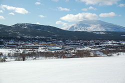
 View of the village | |
| Coordinates: 62°16′33″N 10°46′57″E / 62.27594°N 10.78239°E | |
| Country | Norway |
| Region | Eastern Norway |
| County | Innlandet |
| District | Østerdalen |
| Municipality | Tynset Municipality |
| Area | |
| • Total | 2.91 km2 (1.12 sq mi) |
| Elevation | 493 m (1,617 ft) |
| Population (2021)
[1] | |
| • Total | 2,779 |
| • Density | 957/km2 (2,480/sq mi) |
| Time zone | UTC+01:00 ( CET) |
| • Summer ( DST) | UTC+02:00 ( CEST) |
| Post Code | 2500 Tynset |
Tynset is the administrative centre of Tynset Municipality in Innlandet county, Norway. The village is located along the river Glåma, about halfway between the villages of Tolga and Alvdal. The village includes a central urban area with several surrounding residential areas. The smaller villages of Fåset (to the southwest) and Telneset (to the northeast) lie a short distance away from Tynset. [3]
The 2.91-square-kilometre (720-acre) village has a population (2021) of 2,779 and a population density of 957 inhabitants per square kilometre (2,480/sq mi). [1]
Tynset Church is located in the village.
References
- ^ a b c Statistisk sentralbyrå (1 January 2021). "Urban settlements. Population and area, by municipality".
- ^ "Tynset (tettsted)". yr.no. Retrieved 10 February 2022.
- ^ Mæhlum, Lars, ed. (1 November 2021). "Tynset (tettsted)". Store norske leksikon (in Norwegian). Kunnskapsforlaget. Retrieved 10 February 2022.

