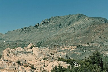
| Twin Peaks | |
|---|---|
 West aspect at sunset | |
| Highest point | |
| Elevation | 12,323 ft (3,756 m) NAVD 88 [1] |
| Prominence | 463 ft (141 m) |
| Coordinates | 38°04′59″N 119°21′27″W / 38.08310°N 119.3574°W [1] |
| Geography | |
| Location | Yosemite National Park, Tuolumne County, California, U.S. |
| Parent range | Sierra Nevada |
| Climbing | |
| Easiest route | class 2 [1] |
Twin Peaks is a mountain in the northern part of Yosemite National Park, north of Tuolumne Meadows. It is the 15th highest mountain in Yosemite National Park. [2]
On Twin Peaks's particulars
Twin Peaks is near Twin Peaks Pass. [3] [4] [5]
Twin Peaks is at times a somewhat mysterious mountain in Yosemite, on the uppermost reaches of Virginia Canyon. From the east along US 395, Twin Peaks can be difficult to identify.
Twin Peaks has two summits, though they are not twins. The west summit is the high point at 12,323 feet (3,756 m), which makes it slightly higher than its famous neighbor, Matterhorn Peak, which is 12,279 feet (3,743 m) high. [1]
Twin Peaks is also near Whorl Mountain, Black Mountain, Excelsior Mountain, Mount Warren, Virginia Peak, and North Peak. Twin Peaks is west and a bit north of Mono City. [6]
Climate
| Climate data for Twin Peaks (Yosemite) 38.0842 N, 119.3527 W, Elevation: 11,850 ft (3,612 m) (1991–2020 normals) | |||||||||||||
|---|---|---|---|---|---|---|---|---|---|---|---|---|---|
| Month | Jan | Feb | Mar | Apr | May | Jun | Jul | Aug | Sep | Oct | Nov | Dec | Year |
| Mean daily maximum °F (°C) | 30.3 (−0.9) |
29.0 (−1.7) |
31.7 (−0.2) |
35.6 (2.0) |
43.3 (6.3) |
53.1 (11.7) |
61.1 (16.2) |
60.5 (15.8) |
54.7 (12.6) |
45.5 (7.5) |
36.5 (2.5) |
30.2 (−1.0) |
42.6 (5.9) |
| Daily mean °F (°C) | 20.7 (−6.3) |
18.8 (−7.3) |
21.0 (−6.1) |
24.1 (−4.4) |
31.2 (−0.4) |
40.6 (4.8) |
48.1 (8.9) |
47.4 (8.6) |
41.8 (5.4) |
33.8 (1.0) |
26.4 (−3.1) |
20.7 (−6.3) |
31.2 (−0.4) |
| Mean daily minimum °F (°C) | 11.0 (−11.7) |
8.6 (−13.0) |
10.4 (−12.0) |
12.6 (−10.8) |
19.2 (−7.1) |
28.1 (−2.2) |
35.2 (1.8) |
34.3 (1.3) |
29.0 (−1.7) |
22.2 (−5.4) |
16.3 (−8.7) |
11.3 (−11.5) |
19.9 (−6.8) |
| Average precipitation inches (mm) | 9.23 (234) |
7.95 (202) |
7.24 (184) |
3.85 (98) |
2.40 (61) |
0.65 (17) |
0.78 (20) |
0.68 (17) |
0.59 (15) |
2.49 (63) |
3.88 (99) |
8.00 (203) |
47.74 (1,213) |
| Source: PRISM Climate Group [7] | |||||||||||||
References
- ^ a b c d "Twin Peaks". SummitPost.org. Retrieved 2019-03-17.
-
^ mrchad9.
"Yosemite's Highest Peaks". summitpost.org. Retrieved 17 March 2019.
{{
cite web}}
: CS1 maint: numeric names: authors list ( link) - ^ Steeleman. "Twin Peaks". summitpost.org. Retrieved 17 March 2019.
- ^ Smith, Douglas (August 3, 2003). "Sawtooth Ridge and Environs". climber.org. Retrieved 17 March 2019.
- ^ Secor, R. J. "The High Sierra: Peaks, Passes, Trails". The Mountaineers Books. Retrieved 17 March 2019.
- ^ "google".
-
^
"PRISM Climate Group, Oregon State University". PRISM Climate Group, Oregon State University. Retrieved October 8, 2023.
To find the table data on the PRISM website, start by clicking Coordinates (under Location); copy Latitude and Longitude figures from top of table; click Zoom to location; click Precipitation, Minimum temp, Mean temp, Maximum temp; click 30-year normals, 1991-2020; click 800m; click Retrieve Time Series button.


