Turbot (pronounced 'terbet', not 'turbo') Street is not part of naming series of female British royalty used for the other parallel streets in the CBD.[1][2] Turbot was an indigenous word used by the local
Turrbal people.[3]
Turbot Street as a name existed prior to 1860.[4] Appearing on Ham's 1863 map, a short street, it ran from today's
North Quay, past the Roma Street intersection (then 'New Street') towards Albert and
Edward Streets, all of functional 0.385 kilometres (0.239 mi).[5] The western end of the street abutting the
Brisbane River also had
ferry steps, towards the then-Stanley Street,
South Brisbane.[6][7] The
ferry point was closed in May 1875, and within a year the old shed was harbouring 'idle and disorderly people'.[8][9]
To the north of North Quay, Turbot and George Streets was a dammed water hole known as Tank Stream which served as the colony's water supply from 1842 (and later gave its name to Tank Street).[10] By the 1880s new water supplies were found and saw that area opened up to commercial premises.[11] The 1850s, following the 'Hungry '40s', saw bullock teamsters staying at Humber's Forge on the corner of Turbot and George Streets.[12] The section between George and Albert Streets was fairly much unpassable to vehicular traffic due to the deep gully running from Tank Street to Ann Street.[13]
A ladies seminary, or 'school for young girls', was opened on the street in 1866, and was to include the teaching of English, French, and music.[14]
Over the years, the construction of Turbot Street underwent various changes. Edward Street intersecting with Turbot Street was altered ca. 1867.[15] In 1880, soil material from the road cutting of Ann Street was moved to Turbot Street between George and Roma Streets.[16] Another cutting of Turbot Street occurred in 1884.[17] By 1926 Turbot Street had extended from its original North Quay—Albert Street length, to Edward and Upper Edward Streets, a change from 0.385 kilometres (0.239 mi) to 0.600 kilometres (0.373 mi) long.[18]
In December 1877, Alderman Pettigrew made a motion before the town council,[19]
In order to relieve Queen-street of the traffic from the railway station to the Valley, that Turbot-street from Roma-street to Edward-street, thence by that street to Wickham-terrace, and thence by that terrace to near Wharf-street, be put in such passable order as will enable traffic to pass that way instead of by the way of Queen-street.
The year 1886 also saw the
asphalting of footpaths on both sides of Turbot Street being undertaken.[20]
The looseness of soil and presence of rock resulted in the death of two workers, Patrick Gleeson and Thomas McCullough, at the Turbot Street railway cutting in late 1888.[21] The railway was extended from the 1873
Roma Street to
Central terminus by 1889.
The major
1893 Brisbane flood, compared to Queen Street, had little impact on Turbot Street.[22] Electric street lighting started to be introduced to the area by 1898.[23] In 1900 Turbot Street was proposed as a new
Brisbane town hall 3.5-acre site, at the top of Edward Street and near the railway station; the extending of Turbot Street to Creek Street, closing Upper Edward Street.[24] At this time the land reserve above Central Rail Station had been set-aside as a school reserve. With the municipal hall proposal not progressed by 1904, Turbot Street was not extended.[25]
Public
telephone boxes appeared after 1910.[26] Street
gas lamps were still being superseded by electric lighting by 1919, between the
Edward Street to
Roma Street sections.[27] Never explained was the serious explosions of five postal department electric
utility hole covers on Monday, 28 July 1913.[28]
In late-1917, a deputation of businessmen protested the closure of the street around the fruit markets and police barracks to traffic.[29] This was introduced due to traffic congestion in that area, as well as issues created by earlier colonial land divisions. It was stated that over 400
horse carts used the area between 8.30 am and 1.00 pm, as well as being a thoroughfare from
Spring Hill. The closure was intended for land resumption by the government between Roma and Albert Streets.[30] A 1924 photograph shows the road again open, and two-directional traffic flow.[31]
On 23 October 1922, the death of a fruit vendor Randolph Nolan Birrell occurred on the street. After leaving the fruit markets following a hard fall against a truck, an unsteady Birrell appearing inebriated, went across to a pie
cart. The 'Pieman King' told Birrell that he could not get a pie without money. Birrell then went to the front of the cart and hit the pony drawing it soundly on the nose. Confronted, the owner pushed away Birrell, who fell backwards and struck his head on the footpath. Regaining consciousness a short while later, he was then charged with public drunkenness before being taken to the watchhouse. Transported to hospital, after his death, he was determined to have died of a fracture to the skull.[32][33] Charges of unlawful killing against the pieman were later discontinued.
A newspaper sensation occurred the following year at one of the street's
boarding houses when on 16 February 1923 a male tried to use a .32
calibre revolver to unlawfully kill a female, after she indicated she would not leave her allegedly-violent husband.[34]
During
World War II, a tunnel and large underground
air raid shelter were proposed on the northern side of Turbot Street.[35] A fire was also labelled as suspected
sabotage during this period. On Tuesday, 13 January 1942 saw tragedy when three
fire brigade officers died in a fire at the R. M. Gow Pty Ltd office and warehouse.[36] Stock including £65,000 of emergency food supplies was destroyed, and large building valued at £25,000 was ruined; impacting 200 employees. Third Officer Alfred Lambert and firemen Henry Schirmer and George Uren were overcome by smoke and fumes in the office. To 1951, this was the worst brigade disaster.[37]
BAFS Building, George Street facade, 2018
The 'Arcade Murder' of 19-year-old typist Bronia Mary Armstrong occurred near the
BAFS Institute rooms on 10 January 1947, where a 49-year-old accountant was charged.[38][39] Described by the presiding judge as 'probably one of the most brutal and pathetic cases in the history of Queensland crime', the suspect was found guilty, sentenced to life at
Boggo Road Gaol, and took his own life nine days later on 21 March 1947.
Following on from the extension of the railway line and tunnel underway from Roma Street in 1889, concern with the weight of the first Trades Hall over the tunnel resulted in land resumption, with a new site selected at Upper Edward Street for the hall.[40] The presence of the second trade union hall with the intersection along Turbot Street with Edward Street also meant
Labour Day processions and
street marches on Turbot Street. This included the 1927 lock-out of 1500 railwaymen,[41] and 1948 clash between police and
communists.[42] The poem 'The Tears of Turbot-street' by E. N. MacCulloch was penned in 1927 with reference to the Trades Hall and Labour Day.[43]
Trams never ran on Turbot Street, although they crossed it at Edward Street.[44] In 1960, the Gardens trolley bus route was altered to include Turbot Street, although
Brisbane trolley buses ceased service on 13 March 1969 and were replaced by buses.[45]
At some time, Turbot Street connected straight through to Wickham Street (a change from 0.6 kilometres (0.37 mi) to 1.4 kilometres (0.87 mi) long), and Ann and Turbot Streets became a
one-way pair.
RACQ representations sought the highly congested area at the produce markets become one-way.[46] A later 1954 proposal to make the street one-way between George and Roma Streets was also to assist the markets through increased traffic speed, and allow more space for more retailers.[47]
In 2009, the vehicle speed limit for the Brisbane CBD was reduced to 40
km/h, except for Ann and Turbot Streets which remained at 60 km/h (Ann Street's speed was lowered to 40 km/h on 5 November 2018, east of Wharf Street, to the Riverside Expressway).[48]
Landmarks
Many Brisbane landmarks are or were located on Turbot Street (as numbered, starting from the intersection at the
Riverside Expressway):
corner with
North Quay (right-side) – Inns of Court
facility. First purchased in 1960 by the
Barristers Chambers Limited, the building consisted of some 60 chambers. In the mid-1980s, it was replaced by a twenty-level Inns of Court[49]
corner with North Quay – former site of the Adult Deaf and Dumb Institute, later the Queensland Deaf Society (opened 1918)[50]
former site of the Richmond Villa
boarding establishment, near North Quay. Operated by Mrs Raphael Lewin (1870s–1906), Mrs Bartley (1906–), until at least 1934 with Annie Kelly.[51] By 1946, owned by the
Independent Order of Rechabites, the site was sold to
McDonnell & East for future expansion, for £5000[52]
former site of the Marlborough House boarding establishment, near North Quay (1900s), as well as Ashford Villa (1886) near North Quay, and Mrs Lowther's Clare Cottage (1884) near George Street
32 Turbot Street (left-side) –
Santos Place (2009) was formerly a warehouse and laneway for
McDonnell & East merchant store. Prior to this, the site was Adam Fiebig's two-story Crown Hotel[53]
33 Turbot Street (right-side) – former site of The Hawaiian Eye and The Manor
nightclubs (1960s)[54]
former location of Kelly's British Empire Hotel (ca. 1865), at the intersection with
George Street.[55] The new hotel included seven large bedrooms, dining rooms,
parlours, and
stables[56]
Fruit and produce market building in Turbot Street, circa 1910former Turbot Street Fruit Market site as part of the Brisbane Fruit and Produce Exchange, with a building frontage of 198 feet (60 m).[57] Opened in 1906, wholesalers established a market as a rival to the nearby municipally-regulated Roma Street Markets, until the creation in 1964 of the
Rocklea markets.[58] Due to the traffic congestion, it was proposed to move both the Roma Street and Turbot Street markets, possibly towards Countess Street on the other side of the railway yards[59]
64 Turbot Street (left-side) – former site of The Open Door
nightclub (1960s)[54]
former location of the Female Refuge and Infants Home (1880–1918), also known as Mrs Drew's Home,[60] until it was merged with Saint Mary's Home,
Taringa, on the Toowong property in 1919[61]
Roma Street Police Station, 1883
former site of the
Roma Street Police Station (1878–1967) (right-side). The building was demolished to make way for the Turbot Street overpass. A site plaque was dedicated in July 1988.[62] Before the police station was Mrs Hughes' cottage, and prior to that, the Brisbane horse and cattle pound[53]
Sir William Glasgow Memorial (1964) (right-side), in recognition of Queensland-born soldier and senator (Queensland Heritage Register-listed)
143 Turbot Street, corner with Albert Street (SE corner; right-side) –
Suncorp Plaza, formally the
SGIO building, completed in 1971 and once was the
tallest building in Brisbane. In the 1970s the 'Top of the Town' glamorous lounge bar and club was renown[63]
168 Turbot Street (left-side) –
Brisbane Dental Hospital and College, an imposing, neo-Georgian, two-storey, rendered masonry building, built from 1938 to 1941 (Queensland Heritage Register-listed). It backs onto Wickham Park, and extended to the top of the cliff along Turbot Street, before King Edward Park
locale of a former Brisbane
Gymnasium Club, next to the dental hospital.[64] An organisation was in place from February 1882, but the building was not constructed until 1888.[65]
The classroom is 60ft by 40ft., and 20ft. to the wall-head, with an open queen-post roof, giving an additional height of 8ft. to the collar-ties, the roof itself being lined underside of purlins, which will, when completed, present a finished and pleasing appearance. The roof timbers are of colonial pine. The building is of hardwood framing throughout with cross braces, ties, &c. At the rear of the classroom are two dressing-rooms 14ft. 6in. by 10ft., and a bathroom 10ft. by 7ft., the dressing-rooms being fitted up with the necessary lockers for members. The porch which faces towards the Edward Street side is 12ft. by 6ft. with flight of steps to the entrance, and is enclosed with handsome iron railing.
Involved with
women's boxing in Australia, it was also used as a dance hall. By 1935 the building was a home for the unemployed. The area towards Jacob's Ladder was to become part of the unrealised new government precinct[66][67]
Public art (
Forme del Mito: Forms of Myth; 1983) at intersection with Edward Street, beside the air raid shelter, Jacob's Ladder, and the IBM building
corner with Edward Street (SW corner; right-side) – former site of the
South African War Memorial of a mounted soldier, unveiled in December 1919. It was established from funds from 1902, with a total cost of £1750 for the casting of the statue, with the pedestal and engraving of the names another £785.[68] It is now in the nearby
ANZAC Square
309 Edward Street 'Rail Centre 2 Plaza' building stretching above Turbot Street to 317 Edward Street (left-side) – building also houses the
Museum of Lands, Mapping and Surveying
Central railway station (right-side), serving by all suburban and interurban City network lines
73 Wickham Terrace intersecting Turbot Street (left-side) –
Inchcolm, Spring Hill, a heritage-listed former office 1930 building
32 Wickham Terrace (right-side) – Saint Andrew's Lutheran Church, and nearby
All Saints Anglican Church, Brisbane, a heritage-listed 1869-construction church
Named in honour of King
Edward VII (1841–1910) in the early part of the 20th century, the one-acre parklands is part of the Wickham Park and
Observatory Park recreation area green space that was part of Turbot Street to
Wickham Terrace, Brisbane. While Wickham Park was owned by the municipal council, King Edward Park was state government land.[70] It is bounded to the east by
Jacob's Ladder.
In February 1990, the park was reopened as a sculpture park. It contains art works by:
Robert J. Morris, with work 'Juxtaposition I' (1990)
Fumio Nishimura, with work 'Memories of wind' (1986) in granite, formerly from the
World Expo 88 site
Robert Parr (1923–), with work 'Still life with landscape' (1990) in painted steel.
Cathedral Square
East from Wharf Street, and between Turbot and Ann Streets is Cathedral Square. Its name comes from the nearby
St John's Anglican Cathedral.
In 1887 this area was set aside for the construction of a new
fire station.[71] The
Brisbane Fire Brigade Headquarters was officially opened on 11 November 1908.[72] A move of the headquarters was proposed in 1943 to Kemp Place and Ivory Street,
Fortitude Valley, Brisbane, although this was not achieved until 1964.[73] A plaque on the site notes the change from 'a volunteer bucket brigade to horse-drawn steam pumps, to a motorised permanent fire-fighting force'.
Within the park beside Turbot Street is the statute 'El emigrante' unveiled in February 2000 to honour the early
Lebanese settlers who from about 1860 established a presence in Australia, 'sewing the bonds of loyalty, friendship and hard work'.
^"Latest telegrams". Telegraph (Brisbane). No. 777. Queensland, Australia. 26 March 1875. p. 2. Retrieved 29 April 2019 – via National Library of Australia.
^"The Brisbane Courier". The Brisbane Courier. Vol. XXX, no. 2, 695. Queensland, Australia. 10 January 1876. p. 2. Retrieved 29 April 2019 – via National Library of Australia.
^"Classified Advertising". The Brisbane Courier. Vol. XXIII, no. 3, 412. Queensland, Australia. 4 September 1868. p. 4. Retrieved 29 April 2019 – via National Library of Australia.
^"Municipal Council". The Brisbane Courier. Vol. XXXIV, no. 4, 023. Queensland, Australia. 13 April 1880. p. 3. Retrieved 29 April 2019 – via National Library of Australia.
^"Municipal Council". The Brisbane Courier. Vol. XXXII, no. 3, 298. Queensland, Australia. 12 December 1877. p. 3. Retrieved 29 April 2019 – via National Library of Australia.
^"The Brisbane Courier". The Brisbane Courier. Vol. XLII, no. 9, 009. Queensland, Australia. 29 November 1886. p. 4. Retrieved 12 May 2019 – via National Library of Australia.
^"Fatal Accident". The Week. Vol. XXVI, no. 673. Queensland, Australia. 10 November 1888. p. 14. Retrieved 29 April 2019 – via National Library of Australia.
^"Disastrous floods". The Brisbane Courier. Vol. XLIX, no. 10, 940. Queensland, Australia. 6 February 1893. p. 3 (Second Edition). Retrieved 29 April 2019 – via National Library of Australia.
^"New town hall". The Brisbane Courier. Vol. LVII, no. 13, 336. Queensland, Australia. 9 October 1900. p. 6. Retrieved 3 May 2019 – via National Library of Australia.
^"City Council". Telegraph (Brisbane). No. 11888. Queensland, Australia. 23 December 1910. p. 7 (Second edition). Retrieved 29 April 2019 – via National Library of Australia.
^"City Council". Telegraph (Brisbane). No. 14, 395. Queensland, Australia. 14 January 1919. p. 3 (Second edition). Retrieved 29 April 2019 – via National Library of Australia.
^"State Markets". Telegraph (Brisbane). No. 13992. Queensland, Australia. 27 September 1917. p. 3 (Second edition). Retrieved 29 April 2019 – via National Library of Australia.
^"Brisbane illustrated". Telegraph (Brisbane). No. 16, 213. Queensland, Australia. 15 November 1924. p. 11 (Second edition). Retrieved 29 April 2019 – via National Library of Australia.
^"Pie cart scuffle". Daily Mail (Brisbane). No. 6439. Queensland, Australia. 17 November 1922. p. 3. Retrieved 29 April 2019 – via National Library of Australia.
^"I'm Dead Now". Truth (Brisbane newspaper). No. 1, 185. Queensland, Australia. 19 November 1922. p. 5. Retrieved 29 April 2019 – via National Library of Australia.
^"Turbot Street Sensation". Telegraph (Brisbane). No. 15, 675. Queensland, Australia. 23 February 1923. p. 2 (Second edition). Retrieved 29 April 2019 – via National Library of Australia.
^"Trades Hall deal". Toowoomba Chronicle. Vol. LII, no. 27. Queensland, Australia. 1 February 1918. p. 6. Retrieved 29 April 2019 – via National Library of Australia.
^"Sensational clash". Brisbane Telegraph. Queensland, Australia. 17 March 1948. p. 2 (Last race). Retrieved 29 April 2019 – via National Library of Australia.
^"A Tram Accident". The Brisbane Courier. No. 18, 890. Queensland, Australia. 3 August 1918. p. 12. Retrieved 29 April 2019 – via National Library of Australia.
^"Deaf and Dumb". Telegraph (Brisbane). No. 14, 127. Queensland, Australia. 5 March 1918. p. 5. Retrieved 29 April 2019 – via National Library of Australia.
^"Woman's death". The Courier-Mail. No. 113. Queensland, Australia. 6 January 1934. p. 8. Retrieved 29 April 2019 – via National Library of Australia.
^
ab"Bygone Brisbane". The Brisbane Courier. No. 21, 192. Queensland, Australia. 26 December 1925. p. 17. Retrieved 29 April 2019 – via National Library of Australia.
^
ab"Club list". A history of Brisbane nightclubs 1950 to 2000. 2015. Retrieved 29 April 2019.
^"Female Refuge and Infants Home (1870 – 1919)". Find & Connect: History and information about Australian orphanages, children's homes and other institutions. Commonwealth of Australia. 9 April 2018. Retrieved 29 April 2019.
^"The Brisbane Gymnasium". Telegraph (Brisbane). No. 17, 840. Queensland, Australia. 7 February 1930. p. 20 (5 o'clock city edition). Retrieved 29 April 2019 – via National Library of Australia.
^"Brisbane Gymnasium". The Brisbane Courier. Vol. XLIV, no. 9, 357. Queensland, Australia. 11 January 1888. p. 5. Retrieved 12 May 2019 – via National Library of Australia.
^"Crying need". Morning Bulletin. No. 21, 543. Queensland, Australia. 9 August 1935. p. 5. Retrieved 12 May 2019 – via National Library of Australia.
^"The Brisbane Courier". The Brisbane Courier. Vol. XLIV, no. 9, 337. Queensland, Australia. 17 December 1887. p. 5. Retrieved 12 May 2019 – via National Library of Australia.
^"Our Illustrations". The Queenslander. No. 2228. Queensland, Australia. 21 November 1908. p. 29. Retrieved 12 May 2019 – via National Library of Australia.


.jpg)
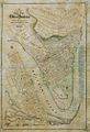 Map showing a short Turbot Street, 1863
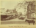 Fruit market, September 1907
 Fruit and produce market building, ca. 1910
 BAFS Building, Turbot Street facade, 2015
 Roma Street Police Station plaque, 2019
 Brisbane Dental Hospital and College, June 1940
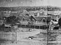 Brisbane Female Refuge and Infants Home ca. 1885, looking south-east
 First premises of the Queensland Stock Institute (ca. 1953)
 Commonwealth Meteorological Bureau, ca. 1921
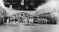 Members of the Turbot Street Gymnastics Club, 1922
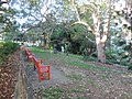 King Edward Park towards Jacob's Ladder, 2019
 King Edward Park towards Turbot Street, 2019
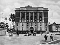 Jacob's Ladder to the left of Brisbane Trades Hall, ca. 1928
 Air raid shelter, King Edward Park, and the start of Jacob's Ladder, 2019
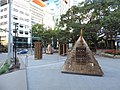 Arnaldo Pomodoro's sculptures forming 'Forme del Mito: Forms of Myth' (1983), 2019
 View from Turbot Street down Edward Street, 2019
 Rail Centre 2 Plaza building spanning Turbot Street, 2019
 Looking east towards Fortitude Valley, 2019
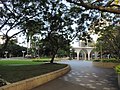 Cathedral Square, 2019


_Building,_corner_of_George_and_Turbot_Street,_Brisbane_-_3.JPG)


