| Tskhenistsqali | |
|---|---|
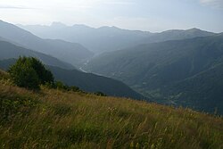
 Tskhenistsqali valley in Lower Svaneti | |
| Native name | ცხენისწყალი ( Georgian) |
| Location | |
| Country | Georgia |
| Physical characteristics | |
| Source | |
| • location | Caucasus Major |
| Mouth | Rioni |
• coordinates | 42°07′31″N 42°17′56″E / 42.1252°N 42.2989°E |
| Length | 176 km (109 mi) |
| Basin size | 2,120 km2 (820 sq mi) |
| Basin features | |
| Progression | Rioni→ Black Sea |

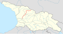
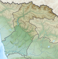
Tskhenistsqali ( Georgian: ცხენისწყალი, Cxenisċqali, also: Tskhenistskali) [1] is a river in northern Georgia. Its source is in the main range of the Caucasus Mountains, in the easternmost part of the Lentekhi Municipality, lower Svaneti. A tributary of the river Rioni, it is 176 km (109 mi) long, and has a drainage basin of 2,120 km2 (820 sq mi). [2] It flows through the small towns Lentekhi and Tsageri and joins the Rioni near the town of Samtredia. The main tributaries of Tskhenistskali are: Zsekho, Kheleldula, Janolula ( from the right ), Kobishuri, Leuseri, Khopuri (from the left).
From etymological standpoint the name is derived from the Georgian words ცხენი (Cxeni, " horse") and წყალი (Tsqali, " water"), thereby meaning "horse water" and is therefore identified with the ancient Hippus river mentioned by Arrian (Periplus, 13).
References
- ^ Tskhenistskali, Georgia Mindat.org
- ^ Statistical Yearbook of Georgia: 2020, National Statistics Office of Georgia, Tbilisi, 2020, p. 12.

