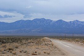
| Troy Peak | |
|---|---|
 Seen from the White River Valley | |
| Highest point | |
| Elevation | 11,302 ft (3,445 m) NAVD 88 [1] |
| Prominence | 4,790 ft (1,460 m) [2] |
| Coordinates | 38°19′10″N 115°30′07″W / 38.319350722°N 115.501921761°W [1] |
| Geography | |
| Location | Nye County, Nevada, U.S. |
| Parent range | Grant Range |
| Topo map | USGS Troy Canyon |
| Climbing | |
| Easiest route | Southeast ridge: steep hike/ scramble |
Troy Peak is the highest mountain in the Grant Range in northeastern Nye County, Nevada, United States. [2] It is the thirty-sixth highest mountain in Nevada. [3] Troy Peak also ranks as the third-most topographically prominent peak in Nye County and the fourteenth-most prominent peak in the state. [4] The summit is located 72 miles (116 km) southwest of the city of Ely, within the Grant Range Wilderness of the Humboldt-Toiyabe National Forest.

References
- ^ a b "White Pine Reset". NGS Data Sheet. National Geodetic Survey, National Oceanic and Atmospheric Administration, United States Department of Commerce. Retrieved 2008-11-24.
- ^ a b "Troy Peak, Nevada". Peakbagger.com. Retrieved 2011-05-19.
- ^ "Nevada 11,000-foot Peaks". Peakbagger.com. Retrieved 2014-10-22.
- ^ "Nevada Peaks with 2000 feet of Prominence". Peakbagger.com. Retrieved 2014-10-23.
External links
- "Troy Peak". Geographic Names Information System. United States Geological Survey, United States Department of the Interior. Retrieved 2008-11-24.
- "Troy Peak". SummitPost.org. Retrieved 2011-05-07.
