 Satellite image of Tropical Strom Alberto on August 7, 1988 off
Cape Cod. | |
| Meteorological history | |
|---|---|
| Formed | August 5,1988 [1] |
| Dissipated | August 8, 1988 [1] |
| Tropical storm | |
| 1-minute sustained ( SSHWS/ NWS) | |
| Highest winds | 50 mph (80 km/h) |
| Lowest pressure | 1002 mbar ( hPa); 29.59 inHg |
| Overall effects | |
| Fatalities | None |
| Damage | None |
| Areas affected | United States, Canada |
| IBTrACS | |
Part of the 1988 Atlantic hurricane season | |
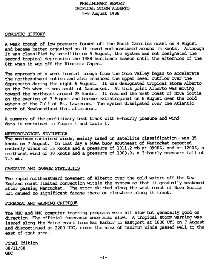
Tropical Storm Alberto was a tropical system of the 1988 hurricane season in the North Atlantic Ocean, which became a tropical cyclone as it moved along the east coast of the United States. Alberto formed from a tropical wave that developed off the coast of South Carolina, USA, on August 5, 1988, [1] [2] and gradually moved northeastward in the Atlantic Ocean, becoming a tropical cyclone on August 7 about 95 km east of Nantucket Island, Massachusetts. [2] Alberto continued its trajectory, heading towards Nova Scotia late on August 7. It became extratropical the following day, dissipating shortly after reaching Newfoundland, Canada. Varied amounts of rain and strong gusts of wind were reported during its passage, with no damage to people or property. [3]
Weather development
.JPG)
On August 4, a tropical wave developed off the coast of South Carolina, USA. [4] Satellite imagery indicated the presence of a low-pressure system, which formed on August 5 into a tropical depression named Deux, located 210 km south-southwest of Cape Fear, North Carolina. Although classified as tropical at the time, it wasn't until August 6 that the system was officially reported as the second tropical depression. [4] [5]
Moving progressively northeastward, it gained tropical status twenty-four hours after its formation, while located 220 km east of the coast of Virginia Beach, Virginia. Under the influence of a weak frontal system from the Ohio Valley, the depression accelerated its trajectory to the northeast. [4] This frontal system improved the structure of the depression, which intensified to become Tropical Storm Alberto on August 7 at around 12:00 UTC, the first named cyclone of the season, located 95 km east of Nantucket, Massachusetts. [2] [6]
Shortly after the formation of the tropical cyclone, the National Hurricane Center, which assigned the name Alberto to the storm, issued a cyclone warning covering the coast from Bar Harbor to Eastport, Maine. Alberto moved rapidly to the northeast at an estimated speed of around 47 km/h. Late in the day on August 7, the cyclone hit the west coast of Nova Scotia, near St. Mary's Bay, with winds of 63 km/h. [7] It briefly touched the Bay of Fundy before crossing the Chignecto Isthmus and Prince Edward Island. Alberto rapidly lost convection as it moved through the cold waters of the Gulf of St. Lawrence, becoming an extratropical cyclone on August 8. [4] The cyclone dissipated shortly afterwards in the Atlantic Ocean north of Newfoundland, [1] [6] and was followed the same day by the formation of Tropical Storm Beryl southeast of Louisiana. [8]
Impact
During Tropical Storm Alberto, heavy rains and thunderstorms affected Maine, USA, but no damage was caused, [3] either to people or property. Approximately 8 mm of rain fell in Lewiston [9] and over 50.8 mm in Millinocket.
Wind gusts of 78 km/h were measured in Yarmouth, Nova Scotia, Canada. [1] [7] Alberto also brought light to moderate precipitation to Canada, particularly to Saint John, New Brunswick. Rainfall of 45.1 mm was measured there. [7] The rains caused some local flooding, forcing the closure of several roads for a short time. [10] Thunderstorm trails from the extratropical cyclone were also observed east of Newfoundland. [7]
References
- ^ a b c d e "1988-Alberto". Environnement Canada. 14 September 2010. Retrieved 20 August 2012..
- ^ a b c "Résumés des saisons de cyclones tropicaux au Canada de 1988, section « La tempête tropicale Alberto (5 - 8 août 1988) »" [Canadian Tropical Cyclone Season Summaries 1988, section "Tropical Storm Alberto (August 5 - 8, 1988)".]. Environnement Canada. Retrieved August 20, 2012..
- ^ a b National Weather Service and Department of Earth and Atmospheric Sciences at the University at Albany State University of New York (2001). "The Distribution of Precipitation over the Northeast Accompanying Landfalling and Transitioning Tropical Cyclones". Retrieved 20 August 2012..
- ^ a b c d "Preliminary Report Tropical Storm Alberto, 05 - 08 August 1988". Hurricane Central. Retrieved 25 August 2012.
- ^ Lawrence, Miles B.; Gross, James M. (1989). "Atlantic Hurricane Season of 1988" (PDF). National Hurricane Center. Retrieved 22 August 2012..
- ^ a b National Hurricane Center (1988). "Preliminary Report for Tropical Storm Alberto". Retrieved 20 August 2012..
- ^ a b c d "Images des vents pour les résumés d'impact des tempêtes de 1988" [Wind images for 1988 storm impact summaries]. Environnement Canada. Retrieved 22 August 2012..
- ^ "Tropical Storm Beryl Preliminary Report (Page 1)" (GIF). National Hurricane Center. 1988. Retrieved 22 August 2012..
- ^ Wayne Cotterly (1996). "Hurricanes and Tropical Storms; Their Impact on Maine and Androscoggin County" (PDF). Retrieved 20 August 2012..
- ^ Toronto Star (8 August 1998). Tropical storm Alberto fizzles out before hitting N.S..