This article has multiple issues. Please help
improve it or discuss these issues on the
talk page. (
Learn how and when to remove these template messages)
|
Tomamae
苫前町 | |
|---|---|
Town | |
 Sunset over Tomamae | |
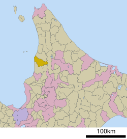
 Location of Tomamae in
Hokkaido (
Rumoi Subprefecture) | |
| Coordinates: 44°18′N 141°39′E / 44.300°N 141.650°E | |
| Country | Japan |
| Region | Hokkaido |
| Prefecture | Hokkaido ( Rumoi Subprefecture) |
| District | Tomamae |
| Area | |
| • Total | 454.50 km2 (175.48 sq mi) |
| Population (September 30, 2016) | |
| • Total | 3,261 |
| • Density | 7.2/km2 (19/sq mi) |
| Time zone | UTC+09:00 ( JST) |
| Website |
www |
| Symbols | |
| Flower | Corydalis ambigua |
| Tree | Sorbus commixta |
Tomamae (苫前町, Tomamae-chō) is a town located in Rumoi Subprefecture, Hokkaido, Japan.
Demographics
As of September 2016, the town has an estimated population of 3,261 and a density of 7.2 persons per km2. The total area is 454.50 km2.
Mascot

Tomamae's mascot is Kumada Tomao (くまだ とまお), better known as Tomao-kun (とまおくん). He is a 7-year-old brown bear cub. He wears a hat that has two badges (a windmill badge and a badge dedciated to agricultural and seafood products). [1]
See also
References
- ^ "くまだ とまお (北海道)". Yuru-Chara Grand Prix.
External links
-
 Media related to
Tomamae, Hokkaidō at Wikimedia Commons
 - Official Website (in Japanese)


