| Grotte di Toirano (Toirano Caves) | |
|---|---|
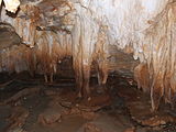
.JPG) Interior view | |
 Location of the caves in Italy | |
| Location |
Toirano ( SV, Liguria, Italy) |
| Coordinates | 44°8′9.6″N 8°12′3.6″E / 44.136000°N 8.201000°E |
| Length | 2,000 m |
| Elevation | 50 m |
| Discovery | 1950 |
| Geology | Karst cave |
| Entrances | 1 |
| Access | Public |
| Show cave opened | 1953 |
| Show cave length | ? |
| Website | Official website |
The Toirano Caves ( Italian: Grotte di Toirano) are a karst cave system in the municipality of Toirano, in the province of Savona, Liguria, Italy.
Overview
The area is situated close to the town of Toirano and few kilometers to the Ligurian Ponente Riviera. The exit " Borghetto Santo Spirito" of A10 motorway is 5 km far from the caves. One of the most important caves is "Basura", discovered in 1950, [1] and shelter of the Cave bear (Ursus spelaeus).
Gallery
-
 Entrance
 -
 Speleothems width widening at certain height
 -
 Speleothems width widening at certain height
 -
-
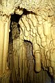
 Stalactites with spikes
 -
 Wide stalactites
 -
 Hall
Hall

.JPG)
.JPG)
.JPG)


See also
References
- ^ (in Italian) Infos on toiranogrotte.it (click on Storia e Scienza section)
External links
Wikimedia Commons has media related to
Toirano Caves.