Tingri County
定日县 • དིང་རི་རྫོང་། Dhringgri | |
|---|---|
 | |
.png) Location of Tingri County (red) within Xigazê City (yellow) and the Tibet Autonomous Region | |
 Tingri County Location of the seat in the Tibet Autonomous Region  Tingri County Tingri County (China) | |
| Coordinates (Tingri County government, Shelkar): 28°39′32″N 87°07′34″E / 28.659°N 87.126°E | |
| Country | China |
| Autonomous region | Tibet |
| Prefecture-level city | Xigazê |
| County seat | Shelkar |
| Area | |
| • Total | 13,861.21 km2 (5,351.84 sq mi) |
| Population (2020)
[1] | |
| • Total | 58,173 |
| • Density | 4.2/km2 (11/sq mi) |
| Time zone | UTC+8 ( China Standard) |
| Website |
www |
| Tingri County | |||||||
|---|---|---|---|---|---|---|---|
| Chinese name | |||||||
| Simplified Chinese | 定日县 | ||||||
| Traditional Chinese | 定日縣 | ||||||
| |||||||
| Tibetan name | |||||||
| Tibetan | དིང་རི་རྫོང་། | ||||||
| |||||||
Tingri County ( Tibetan: དིང་རི་རྫོང་།; Chinese: 定日县) is a county under the administration of the prefecture-level city of Xigazê in the Tibet Autonomous Region of China. [2]
The county comprises the upper valley of the Bum-chu or Arun River, with the valleys of its tributaries, the valleys of the Rongshar Tsangpo and the Lapchi Gang Tsanpo which flow south into Nepal. It is bordered on the south by the main range of the Himalayas, including Mount Everest (Tib. Chomolungma), Makalu and Cho Oyu. The present county administration is located at Shelkar, about 87 km (54 mi) east of Tingri (town). [3]
Tingri is one of the four counties (the other three being Dinjie, Nyalam, and Kyirong) that comprise the Qomolangma National Nature Preserve, [4] a protected area spanning 3.381 million hectares.
Administration divisions
Tingri County is divided into 2 towns and 11 townships.
| Name | Chinese | Hanyu Pinyin | Tibetan | Wylie | ||
|---|---|---|---|---|---|---|
| Towns | ||||||
| Shelkar Town | 协格尔镇 | Xiégé'ěr zhèn | ཤེལ་དཀར་གྲོང་རྡལ། | shel dkar grong rdal | ||
| Gangga Town | 岗嘎镇 | Gǎnggā zhèn | སྒང་དགའ་གྲོང་རྡལ། | sgang dga' grong rdal | ||
| Townships | ||||||
| Tashi Dzom Township | 扎西宗乡 | Zhāxīzōng xiāng | བཀྲ་ཤིས་འཛོམས་ཤང་། | bkra shis 'dzoms shang | ||
| Ronxar Township | 绒辖乡 | Róngxiá xiāng | རོང་ཤར་ཤང་། | rong shar shang | ||
| Qutang Township | 曲当乡 | Qǔdāng xiāng | ཆུ་ཐང་ཤང་། | chu thang shang | ||
| Cogo Township | 措果乡 | Cuòguǒ xiāng | མཚོ་སྒོ་ཤང་། | mtsho sgo shang | ||
| Qulho Township | 曲洛乡 | Qǔluò xiāng | ཆུ་ལྷོ་ཤང་། | chu lho shang | ||
| Chamco Township | 长所乡 | Zhǎngsuǒ xiāng | གྲམ་མཚོ་ཤང་། | gram mtsho shang | ||
| Nyixar Township | 尼辖乡 | Níxiá xiāng | ཉི་ཤར་ཤང་། | nyi shar shang | ||
| Zagor Township | 扎果乡 | Zhāguǒ xiāng | རྩ་སྐོར་ཤང་། | rtsa skor shang | ||
| Kaimar Township | 克玛乡 | Kèmǎ xiāng | གད་དམར་ཤང་། | gad dmar shang | ||
| Pain'gyi Township | 盆吉乡 | Pénjí xiāng | ཕན་སྐྱིད་ཤང་། | phan skyid shang | ||
| Gyaco Township | 加措乡 | Jiācuò xiāng | བརྒྱ་ཚོ་ཤང་། | brgya mtsho shang | ||
Climate
| Climate data for Tingri (1991–2020 normals, extremes 1981–2010) | |||||||||||||
|---|---|---|---|---|---|---|---|---|---|---|---|---|---|
| Month | Jan | Feb | Mar | Apr | May | Jun | Jul | Aug | Sep | Oct | Nov | Dec | Year |
| Record high °C (°F) | 14.7 (58.5) |
15.0 (59.0) |
18.7 (65.7) |
20.8 (69.4) |
23.8 (74.8) |
25.1 (77.2) |
25.8 (78.4) |
23.4 (74.1) |
22.8 (73.0) |
19.3 (66.7) |
17.2 (63.0) |
13.4 (56.1) |
25.8 (78.4) |
| Mean daily maximum °C (°F) | 3.7 (38.7) |
5.1 (41.2) |
8.3 (46.9) |
11.9 (53.4) |
16.1 (61.0) |
20.2 (68.4) |
19.5 (67.1) |
18.2 (64.8) |
17.5 (63.5) |
13.3 (55.9) |
8.8 (47.8) |
5.8 (42.4) |
12.4 (54.3) |
| Daily mean °C (°F) | −6.4 (20.5) |
−4.4 (24.1) |
−0.8 (30.6) |
3.1 (37.6) |
7.6 (45.7) |
12.1 (53.8) |
12.6 (54.7) |
11.6 (52.9) |
10.1 (50.2) |
4.0 (39.2) |
−1.6 (29.1) |
−5.2 (22.6) |
3.6 (38.4) |
| Mean daily minimum °C (°F) | −16.1 (3.0) |
−14.1 (6.6) |
−10.1 (13.8) |
−5.4 (22.3) |
−0.2 (31.6) |
5.2 (41.4) |
7.4 (45.3) |
6.9 (44.4) |
4.1 (39.4) |
−4.2 (24.4) |
−10.9 (12.4) |
−14.9 (5.2) |
−4.4 (24.1) |
| Record low °C (°F) | −27.7 (−17.9) |
−25.3 (−13.5) |
−19.0 (−2.2) |
−14.0 (6.8) |
−8.3 (17.1) |
−4.0 (24.8) |
1.4 (34.5) |
0.2 (32.4) |
−4.1 (24.6) |
−12.3 (9.9) |
−19.0 (−2.2) |
−27.5 (−17.5) |
−27.7 (−17.9) |
| Average precipitation mm (inches) | 1.0 (0.04) |
0.7 (0.03) |
0.6 (0.02) |
2.6 (0.10) |
9.1 (0.36) |
23.0 (0.91) |
108.4 (4.27) |
116.7 (4.59) |
27.1 (1.07) |
1.7 (0.07) |
0.9 (0.04) |
0.5 (0.02) |
292.3 (11.52) |
| Average precipitation days (≥ 0.1 mm) | 0.9 | 0.8 | 0.8 | 1.5 | 3.4 | 6.7 | 16.4 | 17.8 | 7.5 | 0.8 | 0.2 | 0.3 | 57.1 |
| Average snowy days | 1.3 | 1.7 | 2.7 | 4.6 | 4.3 | 0.3 | 0.1 | 0.2 | 0.4 | 1.0 | 0.4 | 0.6 | 17.6 |
| Average relative humidity (%) | 27 | 27 | 29 | 34 | 40 | 48 | 59 | 64 | 56 | 41 | 34 | 28 | 41 |
| Mean monthly sunshine hours | 281.1 | 262.5 | 300.2 | 300.2 | 327.7 | 289.6 | 222.0 | 220.0 | 261.6 | 310.2 | 292.9 | 286.5 | 3,354.5 |
| Percent possible sunshine | 86 | 82 | 80 | 77 | 78 | 70 | 52 | 55 | 72 | 89 | 92 | 90 | 77 |
| Source: China Meteorological Administration [5] [6] | |||||||||||||
Transport
- China National Highway 318
- Shigatse Tingri Airport (under construction)
Gallery
-
![Dampa Sangye, author of the Dingri One Hundred [7][8][9] and founder of Dingri Langkhor [10]](https://upload.wikimedia.org/wikipedia/commons/thumb/9/94/Padampa_Sanggye.jpg/112px-Padampa_Sanggye.jpg)
-
![Machig Labdrön (1055-1149), student of Padampa Sanggye at Dingri Langkhor [11][10]](https://upload.wikimedia.org/wikipedia/commons/thumb/1/19/Machik_Labdron.jpg/112px-Machik_Labdron.jpg)
-
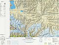
 Map including Tingri (labelled as TINGRI DZONG) (1954)
 -
 Map including Tingri (T'ing-jih) ( DMA, 1981)
 -
![Zhangton Chobar, Lamdre practitioner, b. 1053 in Tingri County [12]](https://upload.wikimedia.org/wikipedia/commons/thumb/b/b7/Zhangton_chobar.jpg/110px-Zhangton_chobar.jpg)
![Dampa Sangye, author of the Dingri One Hundred [7][8][9] and founder of Dingri Langkhor [10]](/info/en/?search=File:Padampa_Sanggye.jpg)
![Machig Labdrön (1055-1149), student of Padampa Sanggye at Dingri Langkhor [11][10]](/info/en/?search=File:Machik_Labdron.jpg)


![Zhangton Chobar, Lamdre practitioner, b. 1053 in Tingri County [12]](/info/en/?search=File:Zhangton_chobar.jpg)
References
- ^ "日喀则市第七次全国人口普查主要数据公报" (in Chinese). Government of Xigazê. 2021-07-20.
- ^ Croddy, E. (2022). China’s Provinces and Populations: A Chronological and Geographical Survey. Springer International Publishing. p. 698. ISBN 978-3-031-09165-0. Retrieved 2024-03-07.
- ^ Footprint Tibet Handbook with Bhutan, p. 296. 2nd edition (1999). Gyume Dorje. Footprint Handbooks, Bath, England. ISBN 1-900949-33-4.
- ^ Department of Forestry, Government of the Tibet Autonomous Region, People's Republic of China, ‘’Report on Protected Lands in the Tibet Autonomous Region’’ Lhasa: Tibet Autonomous Region Government Publishing House, 2006
- ^ 中国气象数据网 – WeatherBk Data (in Simplified Chinese). China Meteorological Administration. Retrieved 27 August 2023.
- ^ 中国气象数据网 (in Simplified Chinese). China Meteorological Administration. Retrieved 27 August 2023.
- ^ Sorensen, Michelle (2011). "Padampa Sanggye". The Treasury of Lives. Retrieved 2017-07-24.
- ^ "The Tingri Hundred". Tibetological. Retrieved 2017-07-24.
- ^ "ding ri glang 'khor". Rangjung Yeshe Wiki - Dharma Dictionnary. 2005. Retrieved 2017-07-24.
- ^ a b "Dingri Langkhor". The Treasury of Lives. Retrieved 2017-07-24.
- ^ Sorenson, Michelle (2010). "Machik Labdron". The Treasury of Lives. Retrieved 2017-07-24.
- ^ Gardener, Alexander (2010). "Zhangton Chobar". The Treasury of Lives. Retrieved 2017-07-24.
Further reading
- Annals of Tingri County (in Chinese)

|
| This Shigatse, Tibet location article is a stub. You can help Wikipedia by expanding it. |