| The Sentinel | |
|---|---|
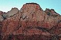
 The Sentinel, northeast aspect, May 2017 | |
| Highest point | |
| Elevation | 7,120 ft (2,170 m) [1] |
| Prominence | 400 ft (120 m) [1] |
| Parent peak | The East Temple [1] |
| Isolation | 0.81 mi (1.30 km) [2] |
| Coordinates | 37°13′53″N 112°58′51″W / 37.23136°N 112.980779°W [1] |
| Geography | |
 The Sentinel Location in Utah  The Sentinel The Sentinel (the United States) | |
| Location |
Zion National Park Washington County, Utah United States |
| Parent range | Colorado Plateau |
| Topo map | USGS Springdale East |
| Geology | |
| Age of rock | Jurassic |
| Type of rock | Navajo sandstone |
| Climbing | |
| First ascent | 1938 Bob Brinton, Glen Dawson |
| Easiest route | class 5 climbing |
The Sentinel is a 7,120+ ft (2,170+ m) elevation Navajo Sandstone summit located near the Court of the Patriarchs in Zion National Park, in Washington County of southwest Utah, United States, that is part of the Towers of the Virgin. [3] The national park map lists the elevation as 7,157-feet.
Description
The Sentinel is located 1.5 mi (2.4 km) north of Zion's park headquarters, towering 3,000 feet (910 m) above the park road and the floor of Zion Canyon. It is set alongside the North Fork of the Virgin River which drains precipitation runoff from this mountain. Its neighbors include Bee Hive, Mount Spry, The East Temple, Mount Moroni, Mountain of the Sun, Twin Brothers, and the Three Patriarchs. This feature's name was officially adopted in 1934 by the U.S. Board on Geographic Names. [3] In 1995, a landslide at the base of The Sentinel dammed the Virgin River and washed out a section of the park road. The Sentinel was once much bigger before a huge rock avalanche fell from it, when 4,800 years ago the Sentinel Slide with a volume of 286 million cubic meters {10.1 billion cubic feet) dammed the river, thereby creating Sentinel Lake which existed for 700 years and filled with sediments, creating Zion's flat valley. [4] [5]
Climate
Spring and fall are the most favorable seasons to visit The Sentinel. According to the Köppen climate classification system, it is located in a Cold semi-arid climate zone, which is defined by the coldest month having an average mean temperature below 32 °F (0 °C), and at least 50% of the total annual precipitation being received during the spring and summer. This desert climate receives less than 10 inches (250 millimeters) of annual rainfall, and snowfall is generally light during the winter. [6]
Gallery
-
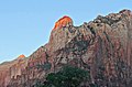
 Sunrise on The Sentinel (centered)
 -
 Court of the Patriarchs in winter. Sentinel, Abraham Peak, Isaac, Moroni
 -
 Bee Hive Peak and The Streaked Wall (left), The Sentinel (right}
 -
 South aspect
 -
 Sentinel Slide
 -
 The Sentinel in autumn
 -
 The Sentinel through the Cottonwoods
 -
-
 Sunrise. ( Bee Hive lower left)
 -
 The Sentinel seen from the Watchman Trail


.jpg)

See also
References
- ^ a b c d "The Sentinel, Utah". Peakbagger.com.
- ^ "Sentinel, The - 7,160' UT". listsofjohn.com. Retrieved 2020-09-03.
- ^ a b U.S. Geological Survey Geographic Names Information System: The Sentinel
- ^ "How a huge landslide shaped Zion National Park | UNews".
- ^ James Kaiser, Zion: The Complete Guide, 1st Edition, 2019, Destination Press, ISBN 978-1940754-40-6
- ^ "Zion National Park, Utah, USA - Monthly weather forecast and Climate data". Weather Atlas. Archived from the original on January 27, 2019. Retrieved 31 August 2020.
External links
- Zion National Park National Park Service
- Weather: The Sentinel
- Sentinel Rock Climbing: mountainproject.com
- Flickr photo
- Sentinel Slide