| The Citadel, Montreal | |
|---|---|
| Montreal, Quebec, Canada | |
 | |
| Type | fortress used to defend the city |
| Site history | |
| Built | 1690 |
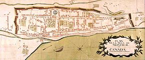
The Citadel of Montreal was a former fortress used to defend the city. It was located at what is now rue Notre-Dame between rue Bonsecours and rue Berri.
Smaller than the one in Old Quebec, the Citadel was built by the French in 1690 replacing the 1658 redoubt at Pointe-à-Callière. It consisted of a barrack structure surrounded by wood stakes palisade and located on a hill along the city's fortification wall. A cannon battery added in 1723.
The fort was demolished by the British in 1821 to allow for the extension of Notre-Dame Street.

See also
References
- Rémillard, François, Old Montreal - A Walking Tour, Ministère des Affaires culturelles du Québec, 1992.
- Albertine Ferland-Angers, La Citadelle de Montréal (1658-1820)
45°30′42″N 73°33′06″W / 45.51167°N 73.55167°W
