| Te Rau-o-te-Huia / Mount Donald McLean | |
|---|---|
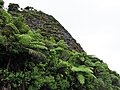
.jpg) View of Te Rau-o-te-Huia / Mount Donald McLean from Huia Road | |
| Highest point | |
| Elevation | 389 m (1,276 ft) |
| Coordinates | 37°00′51″S 174°31′52″E / 37.0143°S 174.53124°E |
| Geography | |
| Location | North Island, New Zealand |
| Parent range | Waitākere Ranges |
| Geology | |
| Age of rock | Miocene |
Te Rau-o-te-Huia / Mount Donald McLean is a hill in the Waitākere Ranges of the Auckland Region of New Zealand's North Island. It is located to the south of the ranges, near the township of Huia. It is the highest peak of the Waitākere Ranges that borders the Manukau Harbour.
Geography and geology
The hill is a 389-metre peak in the Waitākere Ranges. [1] The hill is the source for the south-flowing Baker Stream, [2] and some of the tributaries of the east-flowing Marama Stream. [3] The hill is accessible by Mt Donald McLean Road along Whatipu Road, or by two walking tracks: the Puriri Ridge Track and the Donald McLean Track. A prominent viewing platform can be found at the summit. [4]
Te Rau-o-te-Huia / Mount Donald McLean is a part of the Waitākere volcano, which first began erupting 23 million years ago, during the Miocene era. Most of the volcano had eroded by five million years ago, except for the eastern slopes of the volcano, which were uplifted from the ocean floor and form the modern Waitākere Ranges. [5] [6]
Biodiversity
The hill is vegetated with native bush, including kauri, rimu, nīkau, tōtara, tānekaha, lancewood and rewarewa. The hill is also a habitat for the rare Waitākere rock koromiko Veronica bishopiana and Hall's tōtara, Podocarpus laetus. [4] [7]
History
Te Rau-o-te-Huia / Mount Donald McLean is within the traditional rohe of the Te Kawerau ā Maki iwi, and overlooked a number of kāinga around Huia Bay. The literal translation of Te Rau-o-te-Huia is "The Plumes of the Huia", and the name was used to describe both the mountain and the surrounding bay. [8] The plumes were a metaphor for expressing his pride in the area. [9] [10]
In English, the hill was named after Donald McLean, a government administrator and major figure in Māori- Pākehā relations in the mid-19th Century. [11] [12] During the 1850s, the Gibbons family milled the kauri forest on the north side of Te Rau-o-te-Huia / Mount Donald McLean. [13] Unintentional fires in the early 20th century led to large areas of the hill being deforested, with mānuka scrub propagating in the areas affected by fire. [14]
The hill became popular with trampers by the 1930s, known as a place where Mount Taranaki could be seen on a clear day. [15] In the late 1980s, the walking track to the summit was upgraded. [16]
Gallery
-
 A windswept Hall's tōtara ( Podocarpus laetus) on the slopes of Te Rau-o-te-Huia / Mount Donald McLean
 -
 View from Te Rau-o-te-Huia / Mount Donald McLean towards the Auckland City Centre and Rangitoto
 -
 a tomtit ( Petroica macrocephala) on Te Rau-o-te-Huia / Mount Donald McLean
 -
 Cyathea medullaris on Te Rau-o-te-Huia / Mount Donald McLean
 -
 View over Manukau Harbour from the lookout


References
- ^ "Te Rau-o-te-Huia / Mount Donald McLean". New Zealand Gazetteer. Land Information New Zealand. Retrieved 11 June 2022.
- ^ "Baker Stream". New Zealand Gazetteer. Land Information New Zealand. Retrieved 10 July 2023.
- ^ "Marama Stream". New Zealand Gazetteer. Land Information New Zealand. Retrieved 10 July 2023.
- ^ a b Janssen, Peter (January 2021). Greater Auckland Walks. New Holland Publishers. p. 219-220. ISBN 978-1-86966-516-6. Wikidata Q118136068.
- ^ Hayward, Bruce (2009). "Land, Sea and Sky". In Macdonald, Finlay; Kerr, Ruth (eds.). West: The History of Waitakere. Random House. pp. 8–10, 13. ISBN 9781869790080.
- ^ Hayward, Bruce W. (2006). "The Structure of the Land". In Harvey, Bruce; Harvey, Trixie (eds.). Waitakere Ranges: Ranges of Inspiration, Nature, History, Culture. Waitakere Ranges Protection Society. p. 38. ISBN 978-0-476-00520-4.
- ^ De Lange, PJ (1996). "Hebe bishopiana (Scrophulariaceae)—an endemic species of the Waitakere ranges, west Auckland, New Zealand". New Zealand Journal of Botany. 34 (2): 187–194. doi: 10.1080/0028825X.1996.10410682. ISSN 0028-825X.
- ^ Te Kawerau ā Maki; The Trustees of Te Kawerau Iwi Settlement Trust; The Crown (12 December 2013). "Deed of Settlement Schedule: Documents" (PDF). Retrieved 26 April 2022.
- ^ "Huia". New Zealand Gazetteer. Land Information New Zealand. Retrieved 5 July 2022.
- ^ Diamond & Hayward 1979, p. 42.
- ^ "Mount Donald McLean". New Zealand Gazetteer. Land Information New Zealand. Retrieved 10 July 2023.
- ^ Dench, Alison; Parore, Lee-Anne (2014). Walking the Waitakere Ranges: 45 Coastal and Bush Walks (4th ed.). Auckland: New Holland Publishers. p. 131. ISBN 978-1-86966-426-8. OCLC 894037427. OL 30857674M. Wikidata Q123383221.
- ^ Hayward, B. W.; Diamond, J. T. (1975). "Kauri Dam Sites in the Waitakere Ranges" (PDF). Tane. 6: 105–120. Retrieved 3 May 2022.
- ^ Esler, A. E.; Astridge, Sandra J. (1 December 1974). "Tea tree (Leptospermum) communities of the Waitakere Range, Auckland, New Zealand". New Zealand Journal of Botany. 12 (4): 485–501. doi: 10.1080/0028825X.1974.10428635. ISSN 0028-825X.
- ^ "News of the Day". Auckland Star. Vol. LXVI, no. 231. 30 September 1935. p. 6 – via Papers Past.
- ^ Jones, Sandra (1990). "Donald McLean Track - Notes 30 June 1989" (PDF). Auckland Botanical Society Journal. 22: 23.
Bibliography
- Diamond, John T.; Hayward, Bruce W. (1979). The Māori history and legends of the Waitākere Ranges. The Lodestar Press. ISBN 9781877431210.