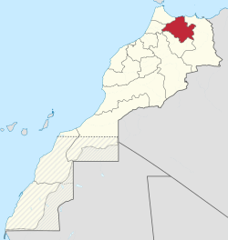
Taza-Al Hoceima-Taounate
تازة الحسيمة تاونات | |
|---|---|
 Location in Morocco | |
| Coordinates: 35°15′N 3°56′W / 35.250°N 3.933°W | |
| Country | |
| Capital | Al Hoceima |
| Area | |
| • Total | 24,155 km2 (9,326 sq mi) |
| Population (2014 census) | |
| • Total | 1,807,036 |
| Time zone | UTC+0 ( WET) |
| • Summer ( DST) | UTC+1 ( WEST) |
This article needs additional citations for
verification. (February 2024) |
Taza-Al Hoceima-Taounate ( Arabic: تازة الحسيمة تاونات) was formerly one of the sixteen regions of Morocco from 1997 to 2015. It was situated in northern Morocco. It covered an area of 24,155 km² and had a population of 1,807,036 (2014 census). The capital was Al Hoceima.
In the 2014 national census, it was the only region in the country whose population was less than in the 2004 census, with 77 fewer residents. In 2015, the region was incorporated with the neighbouring Tangier-Tetouan region to form the Tanger-Tetouan-Al Hoceima region. [1]
Administrative divisions
The region was made up into the following provinces:
- Al Hoceïma Province (now part of the Tanger-Tetouan-Al Hoceima Region)
- Taounate Province (now part of the Fès-Meknès Region)
- Taza Province (now part of the Fès-Meknès Region)
- Guercif Province (since 2009; now part of the Oriental Region)
Cities
References
- ^ Solís, Marlene; Benali, Inam; Cruz, Rodolfo (2019). "Settlement Process and Habitable Space". In Trinidad Requena, Antonio; Soriano-Miras, Rosa M.; Solís, Marlene; Kopinak, Kathryn (eds.). Localized global economies on the northern borderlands of Mexico and Morocco (1st edition 2019 ed.). Cham: Palgrave Macmillan an imprint of Springer Nature. p. 166. doi: 10.1007/978-3-319-96589-5. ISBN 978-3-319-96589-5.