Tanzi
潭子區 Tanzih | |
|---|---|
| Tanzi District | |
 | |
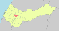
 Tanzi District in Taichung City | |
| Coordinates: 24°13′05″N 120°42′22″E / 24.218°N 120.706°E | |
| Country | Taiwan |
| Special municipality | Taichung |
| Established (District) | 2010 |
| Area | |
| • Total | 25.8497 km2 (9.9806 sq mi) |
| Population (February 2023) | |
| • Total | 108,761 |
| • Density | 4,200/km2 (11,000/sq mi) |
| Time zone | UTC+8 ( CST) |
| Website |
www |
Tanzi District ( Chinese: 潭子區) is a suburban district with a population 108,761 as of February 2023, located north of Taichung, Taiwan. It has an area of 25.8497 km2.
Administrative divisions
Tanxiu, Tanbei, Tanyang, Furen, Toujia, Toujiatung, Jiaxing, Jiafu, Ganzhe, Tungbao, Dafu, Dafeng, Lilin, Jiaren, Xintian and Juxing Village. [1]
Economy
Taichung Tanzi Export Processing Zone is located in the township, providing a variety of employment opportunities.
Hospital
Created by Tzu Chi in 2007.
Native products
Education
- Tanzi Elementary School
- Haiwen Middle School
- Ivy Collegiate Academy
- Sintian Mountain
- Hongwen High School
Tourist attractions
Transportation

References
Wikimedia Commons has media related to
Tanzi District, Taichung.
- ^ "2014 Local Elections". Archived from the original on 2014-12-27. Retrieved 2014-12-27.
