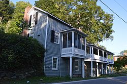
Tankersley Tavern | |
 Front and western end | |
| Location | VA 631, near Lexington, Virginia |
|---|---|
| Coordinates | 37°47′37.5″N 79°25′42″W / 37.793750°N 79.42833°W |
| Area | 2 acres (0.81 ha) |
| Built | c. 1835 |
| Built by | John and Samuel Jordan |
| NRHP reference No. | 88002179 [1] |
| VLR No. | 081-0201 |
| Significant dates | |
| Added to NRHP | November 3, 1988 |
| Designated VLR | April 21, 1987 [2] |
Tankersley Tavern, also known as Old Bridge, is a historic building located near Lexington, Rockbridge County, Virginia. It was built in three sections with the oldest dated to about 1835. It is a two-story, nine-bay, single pile, frame building with an exposed basement and a decorative two-level gallery on the front facade. Also on the property are the contributing washhouse/kitchen, three frame sheds and a stone abutment for a bridge. It was originally built as a toll house (toll gate) at the county end of the bridge crossing the Maury River from the Valley Turnpike into Lexington. It later housed a tavern, canal ticket office, general store, post office, and dwelling. [3]
It was listed on the National Register of Historic Places in 1988. [1]
References
- ^ a b "National Register Information System". National Register of Historic Places. National Park Service. July 9, 2010.
- ^ "Virginia Landmarks Register". Virginia Department of Historic Resources. Retrieved 5 June 2013.
- ^ Henry and Dolores Bausum and Pamela Simpson (February 1987). "National Register of Historic Places Inventory/Nomination: Tankersley Tavern" (PDF). Virginia Department of Historic Resources. and Accompanying photo
- Commercial buildings on the National Register of Historic Places in Virginia
- Commercial buildings completed in 1835
- Buildings and structures in Rockbridge County, Virginia
- National Register of Historic Places in Rockbridge County, Virginia
- 1835 establishments in Virginia
- Shenandoah Valley, Virginia Registered Historic Place stubs
- Rockbridge County, Virginia geography stubs


