| This is an archive of past discussions. Do not edit the contents of this page. If you wish to start a new discussion or revive an old one, please do so on the current talk page. |
| Archive 75 | ← | Archive 79 | Archive 80 | Archive 81 | Archive 82 | Archive 83 | → | Archive 85 |
Baptist designation as Protestant
"Protestantism is the largest Christian religious grouping in the United States. Baptists collectively form the largest branch of Protestantism, and the Southern Baptist Convention is the largest individual Protestant denomination." This is the quote in the Religious section of America however, Baptists never protested out of Catholicism but were a separate distinct belief system, persecuted continuously since its inception, by Jesus Christ, in approximately 25-30 A.D. Baptists hold to the basic truths of the Christian faith and the following six doctrines:
1. The Bible as the sole authority for faith and practice
2. Independent, autonomous churches
3. Regenerated church membership
4. Baptism by immersion of believers only, and the Lord's Supper as the two ordinances of the church
5. Priesthood of all believers and soul liberty
6. Separation of church and state
These principles are known as the "Baptist Distinctives".
A Baptist is one who holds to the great fundamentals of the Christian faith:
1. The Trinity; God the Father, Son, and Holy Spirit, three and yet one, all fully God
2. The absolute inspiration, inerrancy, and infallibility of the Holy Scriptures
3. The incarnation, virgin birth, sinless life, death, burial, resurrection, and substitutionary atonement of Jesus Christ
4. The personal salvation of those who put their faith in the gospel of Christ
5. The reality of the Second Coming, Heaven and Hell
Those who hold to these fundamental doctrines, along with the aforementioned "Baptist Distinctives" are considered Baptists.
One might learn more about the Baptist faith by reading the whole of both "The Faithful Baptist Witness" by Dr. Phil Stringer and "The Trail of Blood" by Dr. J. M. Carroll. 72.24.88.89 ( talk) 02:40, 4 October 2015 (UTC) James H. Senecal 72.24.88.89 ( talk) 02:40, 4 October 2015 (UTC)
- From Baptists: "Baptist churches are widely considered to be Protestant churches, though some Baptists disavow this identity." -- Golbez ( talk) 03:45, 4 October 2015 (UTC)
- While some Baptists believe that their church existed continuously since the time of Christ, most reliable sources date its origins to the 1600s. And Baptist theory owes a lot to Calvin, who of course was a leader of the Protestant Reformation.
TFD (
talk) 04:00, 4 October 2015 (UTC)
- Historically, Baptist theory probably owes more to
Jacobus Arminius than Calvin, except maybe in the sense that
Arminianism grew out of (or, rather, was a response to) early Calvinism. Although recent times have seen the attractive promise of
eternal security lure some Baptists groups in a more Calvinist direction. Either way, the Baptist movement originated in the ideas of the Protestant Reformation.--
William Thweatt
Talk
Contribs 07:48, 4 October 2015 (UTC)
- Baptists among their twenty sects are generally referred to as “Protestants" in common English usage by self identification among Americans, in contradistinction to Roman Catholic Christians. In this case the reference seems to be from a Gallup Poll before the introduction of the Mormon edit source interrupted the narrative. That is what this article should use. Baptists are not alone in holding out an account of their direct connection to the person of Jesus of Nazareth, his contemporary disciples, and the early church — including the Roman Catholic Church and the Church of Latter Day Saints (Mormons). An encyclopedia article using a summary style cannot mark the distinctions among all Christian sects in the specialist manner of a theological journal relative to doctrines of baptism, transubstantiation in communion, the Triune God, etc.
- Historically, Baptist theory probably owes more to
Jacobus Arminius than Calvin, except maybe in the sense that
Arminianism grew out of (or, rather, was a response to) early Calvinism. Although recent times have seen the attractive promise of
eternal security lure some Baptists groups in a more Calvinist direction. Either way, the Baptist movement originated in the ideas of the Protestant Reformation.--
William Thweatt
Talk
Contribs 07:48, 4 October 2015 (UTC)
- Nor should WP provide an affidavit of which one is the sole direct inheritor of the true faith from approximately 25-30 A.C.E. It cannot be said here that some Baptists are the true Christians -- which ones of them did you have in mind, there are so many differing ones -- and all the other Christian sects are apostates to be set apart from the true believers. We should settle on a common reliable source such as Gallup for our classifications of faith. In this case, modern Baptists in the United States are grouped with Protestants, despite where your reading into Stringer and Carroll has brought you. Is there a direct quote from either asserting that modern U.S. Baptists are not Protestants? How is their point of view more generally used than Gallup? TheVirginiaHistorian ( talk) 22:59, 4 October 2015 (UTC)
- Of course there's also the fact that this assertion of being the belief system started by Jesus Christ falls on its face with the very first statement: "The Bible as the sole authority for faith and practice". Jesus 1) could not have started a belief system based solely on a book where much of the text was written after he died and 2) during his life Jesus served as a non-biblical authority for faith and practice. -- Khajidha ( talk) 14:38, 5 October 2015 (UTC)
Form of government
Given the article "Study: Congress literally doesn't care what you think", shouldn't the form of government be listed as something like totalitarian democracy? FourLights ( talk) 16:05, 6 October 2015 (UTC)
- A) There is not study with that title that I can find, just webpages saying it.
- B) Do you really think we should redefine the form of American government every single time a new study comes out that contradicts what is stated in this article? More to the point, why is your article special or better than everything else? --
OuroborosCobra (
talk) 16:15, 6 October 2015 (UTC)
- "Totalitarian democracy" is an oxymoron, a term invented by a handful of writers to describe a theory they held to. In reality, the two terms are mutually exclusive; democracy is the polar opposite of totalitarianism. Furthermore, the USA is not a democracy at all, totalitarian or otherwise. It is a republic. The term "federal republic" is correct. Many people who live here even call the government in Washington the "federal government."
Jsc1973 (
talk) 06:17, 9 October 2015 (UTC)
- I certainly call the national government the "federal government," as I imagine most of the country does. That is the term used in textbooks throughout the country. "Federal Republic" is the correct term. PointsofNoReturn ( talk) 21:49, 9 October 2015 (UTC)
- "Totalitarian democracy" is an oxymoron, a term invented by a handful of writers to describe a theory they held to. In reality, the two terms are mutually exclusive; democracy is the polar opposite of totalitarianism. Furthermore, the USA is not a democracy at all, totalitarian or otherwise. It is a republic. The term "federal republic" is correct. Many people who live here even call the government in Washington the "federal government."
Jsc1973 (
talk) 06:17, 9 October 2015 (UTC)
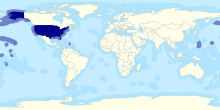
which map should we use?
which map should we use? there was a disagreement between me Dannis243 and Dhtwiki about the map so i want to create a new clear consensus on this Dannis243 ( talk) 11:49, 13 August 2015 (UTC)

.svg)
- Of the two offered, A is superior, as you can actually see elements like Hawaii and the Alaska panhandle in thumbnail, and the Aleutians at all. (Though I note Puerto Rico is not colored in the maps...) -- Golbez ( talk) 14:22, 13 August 2015 (UTC)
- Of the two offered, A is superior, as over 99% of the US population is mapped. (Though another source might supply color for Puerto Rico and US Virgin Islands.) NOAA presents an alternative global perspective showing the US land and water extent for states, CD, territories and possessions. See discussion at Exclusive Economic Zone online. TheVirginiaHistorian ( talk) 14:56, 13 August 2015 (UTC)
- Neither. We should have one map showing the bulk of the country as we do with France etc. We should also have one that shows the entire country, which neither does. TFD ( talk) 15:42, 13 August 2015 (UTC)
- A better shows Alaska and Hawaii. It makes sense to have a map of the 50 states and another of the states + territories/possessions, and I believe the first map works for the 50 states. Dustin (talk) 16:10, 13 August 2015 (UTC)
- Between the two, A seems clearer. However, a version of A that adds shading to the visible territories of Puerto Rico and the US Virgin Islands would be better still. ╠╣uw [ talk 09:40, 14 August 2015 (UTC)
- Version B is continental US only, without island Hawaii or insular territories. Puerto Rico now falls legally within the US customs borders ( Reconsidering the Insular Cases Gerald L. Neuman. Harvard U. Pr. 2015), perhaps the publisher will soon add Puerto Rico.
- We can await the publisher while using Version A in the meantime, or use the NOAA map an alternative global perspective rotated so as to show the US land and water extent for states, DC, territories and possessions. See discussion at Exclusive Economic Zone online. TheVirginiaHistorian ( talk) 06:01, 15 August 2015 (UTC)

- Version B includes Hawaii and the Caribbean parts of the U.S, while excluding parts of the U.S. to the east of Hawaii. Why are they are not highlighted in the map? What reason do you have to exclude insular territories from the map? Why does Version A for example not highlight PR and USVI? In what way is Hawaii different from Guam? TFD ( talk) 06:32, 15 August 2015 (UTC)
- Good points TFD, lets upload the NOAA map
an alternative global perspective with the globe rotated so as to show the US land and water extent for states, DC, territories and possessions.
TheVirginiaHistorian (
talk) 07:49, 15 August 2015 (UTC)
- If the intention is to use that EEZ map (or a similar projection) as the US article's main infobox map, I'm afraid I see a number of problems with that. First, it shifts the continental US off entirely into the upper right corner which I don't think is suitable given what an overwhelming portion of the nation it represents, and results in a map centered on mostly empty ocean. Further, the land area in some of the remote Pacific territories is so minuscule that it'd scarcely be discernible anyway, even if shaded green as in versions A and B (and as is the standard for most of our comparable nation maps). The red-line sea-border outlines are also IMHO inadvisable and inconsistent with the maps we use for most other nations.
- Though I entirely support and agree with making it clear in the article that the territories are part of the US, I'm not convinced it's a good idea to use a projection that strains to include every island at the cost of moving the overwhelming bulk of the nation to the side. I would suggest retaining A's continent-centered projection and shading the visible territories of Puerto Rico and the US Virgin Islands, perhaps accompanied by a note indicating that not all US possessions are shown in that view. ╠╣uw [ talk 17:39, 15 August 2015 (UTC)
- Good points TFD, lets upload the NOAA map
an alternative global perspective with the globe rotated so as to show the US land and water extent for states, DC, territories and possessions.
TheVirginiaHistorian (
talk) 07:49, 15 August 2015 (UTC)
We could use a two map selection as is done for similar articles with the first focusing on the 48 states & DC and the second map showing the entire country. See the maps for France. One shows metropolitan France in a map of Europe, while the second shows all of France in a map of the world. TFD ( talk) 21:50, 15 August 2015 (UTC)


- Support a two-map version, with the EEZ dataset as map#1of2; that pretty closely represents the U.S. as a
superpower (ideally it would be a different
map projection so as to permit the lower 48 to be in the center of the image ... I suggest either
transverse Mercator projection or maybe the
Dymaxion-and-friends many of which are homebrew-American-inventions). Even more ideally, should use dots to indicate airbases (dot-size determined as 50% of the range of non-midair-refueled jets at said airbase), to indicate not just economic superpower status, but also military superpower status; suggest green lines to indicate economic footprint, red dots to indicate military footprint. For map#2of2, something like "Version A" which shows all 50 states (plus Puerto Rico), but preferably add in the green-economic-lines (shown in the EEZ map only at the moment) and the red-airbase-dots (hypothetical at the moment). p.s. I would also support a three-map-solution, with map#1of3 and map#2of3 being the same as in the two-map solution I just outlined, and map#3of3 being the lower 48 only, with the biggest 25 of the ~170 total
commuter-centers legibly named (green borders for cash-power), plus major military facilities also noted (red dots for fire-power).
75.108.94.227 (
talk) 00:29, 16 August 2015 (UTC)
- Let's not. --
Golbez (
talk) 03:13, 17 August 2015 (UTC)
- So, from your comment above I know that you like version_A better than version_B, because the fine details are more visible. And you
WP:IDONTLIKEIT my suggestion ... what specifically? Are you against anything but version_A? Against any form of two-map solution? Against some specific map I suggested, or some specific projection, or some specific feature-illustration?
75.108.94.227 (
talk) 15:35, 17 August 2015 (UTC)
- From my comment above you can know that I hate the idea of including military facilities on the map, it just didn't seem necessary to explain that. --
Golbez (
talk) 14:20, 18 August 2015 (UTC)
- Nope, definitely necessary. Honestly didn't catch your drift from the two-word answer. But since nobody else seems interested by the military-airspace-footprint-idea, seems I will have to await another bangvote, for that one to fly. Pun intended. :-) 75.108.94.227 ( talk) 03:57, 1 September 2015 (UTC)
- From my comment above you can know that I hate the idea of including military facilities on the map, it just didn't seem necessary to explain that. --
Golbez (
talk) 14:20, 18 August 2015 (UTC)
- So, from your comment above I know that you like version_A better than version_B, because the fine details are more visible. And you
WP:IDONTLIKEIT my suggestion ... what specifically? Are you against anything but version_A? Against any form of two-map solution? Against some specific map I suggested, or some specific projection, or some specific feature-illustration?
75.108.94.227 (
talk) 15:35, 17 August 2015 (UTC)
- Alternative maps showing insular territories for #2 map:
US territorial waters, Exclusive Economic Zone internationally recognized by the UN Convention on the Law of the Sea 
United States and its insular areas
- Let's not. --
Golbez (
talk) 03:13, 17 August 2015 (UTC)


- TheVirginiaHistorian ( talk) 15:54, 16 August 2015 (UTC)
I like this one, showing all 50 states with labelling of major cities.

SantiagoFrancoRamos ( talk) 20:33, 16 August 2015 (UTC)
- Unfortunately that won't work because some people here have determined that the United States includes the territories, so anything omitting them can't be used. Someone should inform the United Nations that they are, in fact, wrong. Wikipedia has solved it. -- Golbez ( talk) 03:13, 17 August 2015 (UTC)
- The UN is correct in its Exclusive Economic Zones under its Convention on the Law of the Sea. Fortunately, Wikipedia reports three territories in France and three territories in the US found in the UN list of non-self-governing places as a part of each nation's geographic extent, so as to include those territories claimed by each nation to the United Nations. WP should display a map of the US
Exclusive Economic Zone as internationally recognized.
TheVirginiaHistorian (
talk) 05:28, 17 August 2015 (UTC)
- We can always have our cake and eat it too: why not use one coloration for outlining the economic-zone of the 50 states (plus DC), another coloration for territorial econ-zones, and a third coloration for the econ-zones of the not-fully-agreed-upon territorial claims. 75.108.94.227 ( talk) 15:35, 17 August 2015 (UTC)
- The UN is correct in its Exclusive Economic Zones under its Convention on the Law of the Sea. Fortunately, Wikipedia reports three territories in France and three territories in the US found in the UN list of non-self-governing places as a part of each nation's geographic extent, so as to include those territories claimed by each nation to the United Nations. WP should display a map of the US
Exclusive Economic Zone as internationally recognized.
TheVirginiaHistorian (
talk) 05:28, 17 August 2015 (UTC)
- Version A - For the reasons given (any preferences at all shown for Version B?, even though, by the article edit history, some people prefer it). Also, I don't see the advantage of the other maps introduced (needless to say the confusion they might inject into this debate). The infobox map really just needs to say that this country is here in relation to the rest of the world; it doesn't need to be too comprehensive. Dhtwiki ( talk) 10:56, 17 August 2015 (UTC)
Infobox mockup: maps @ 220px | |
|---|---|
|
| |
 US
Economic Exclusion Zone (EEZ): states, territories and possessions in the UN
Convention on the Law of the Sea
[1] |
- Version A So far we have 5-1 for A as superior, Golbez, Dustin, Huw, Dhtwiki, and TVH. Dannis243 suggesting B? and two alternate map suggestions for the first map. I suggest calling 5-1 a consensus for Map A as the lead locator map.
- Version A I do not see that much of a difference between versions A and B, so I would rather simply stick with the status quo. PointsofNoReturn ( talk) 02:59, 22 August 2015 (UTC)
- TFD notes France has a global locator map for metropolitan France with 99% of its population without territories (comparable to our Map A for the US), and a second map shows “all of France in a map of the world”, including the three French territories on the UN non-self-governing list. The second map should be the US map of its EEZ which includes states, territories and possessions claimed by the US in the State Department Core Report to the UN, — either the version already at Wikimedia Commons above, or perhaps we should upload
[1], or link to the interactive photographic map at
[2].
TheVirginiaHistorian (
talk) 14:14, 17 August 2015 (UTC)
- Well, I agree that we have 6-1 local consensus that version_A is superior to version_B, but that is not the same that as "consensus version_A is superior" without qualification. I like the idea of *some* kind of EEZ map (one of the three or four EEZ variants suggested so far) being used in a two-map solution. I would also support the use of some EEZ variant, as a one-map solution that acts as a replacement for the wiki-traditional version_A. The advantage to version_A is that it is very simple, and gives you the location of the main landmass of the USA, relative to other landmasses.
- The main disadvantage to version_A is that is all it gives. The EEZ map also, obviously, gives the reader the same tidbit of information, the relative position of the main USA landmass relative to other places... but in addition, it gives more information. The EEZ map is more complex, but the complexity is justified, because it provides more information to the reader. We need to strike a balance between too-cluttered-to-understand, versus too-simple-to-be-really-useful. How many people, in our readership, need to be reminded that the main landmass of the USA is located in the continent of North America (not named), and that South America (also not named) is to the south, and that there are nameless oceans to the west and east? That is the informative-content of version_A.
75.108.94.227 (
talk) 15:35, 17 August 2015 (UTC)
- Remember that the infobox map should also be clear at the standard thumbnail size of about 250 pixels, which I suspect is why such maps for most other nations omit text labels and are kept extremely simple.
╠╣uw [
talk 09:50, 18 August 2015 (UTC)
- I've supplied a mockup of the info box with maps only at 220px.
- Remember that the infobox map should also be clear at the standard thumbnail size of about 250 pixels, which I suspect is why such maps for most other nations omit text labels and are kept extremely simple.
╠╣uw [
talk 09:50, 18 August 2015 (UTC)
- ^ Map of the US EEZ omits US claimed Serranilla Bank and Bajo Nuevo Bank which are disputed.
-
TheVirginiaHistorian (
talk) 10:49, 18 August 2015 (UTC)
- Thanks TVH, definitely like the 220px_EEZ_map, as more informative than the 220px_version_A map immediately above it. Almost everybody knows where the continents are already, and most people know Alaska and Hawaii, but the additional blue-zones around the territories is encyclopedically-interesting-additional-info that only the EEZ map offers. Of course, one could always add the bluezones to the version_A-style of map, with a 3D projection... one downside to the particular 220px_EEZ_map shown immediately to the right, is that it somewhat distorts the relative size of Alaska. There are also other map-projection-options, besides the two pictured here, which could be bluezoned. Anyways, I do think the bluezone EEZ data adds something worth keeping. Ping
User:TheVirginiaHistorian, can you label your maximally-preferred EEZ-style map "version C" so that folks can bangvote in favor of it please?
75.108.94.227 (
talk) 03:57, 1 September 2015 (UTC)
- The US EEZ map now labelled Version C is currently in use at
United States#Political divisions to highlight states, territories and possessions. But you hold out the chance at creating a new blue zoned map on another projection, and that sounds interesting. Ping [[
75.108.94.227]]
TheVirginiaHistorian (
talk) 06:50, 1 September 2015 (UTC)
- Yes, I suggest taking a copy of Version_A, which is currently a two-color map (green landmass-of-interest and greyscale everything-else), then converting it to be a three-color map (through the addition of the EEZ dataset). Because of the wiki-tradition of centering the lower 48 in the middle, plenty of EEZ data for the Pacific island territories would be missing or just barely visible, but a modified version_A_with_blue_EEZ_data_added would be a more consistent fit with the usual wiki-traditional simple-orthographic-maps, and might have a better shot at getting bangvotes. Personally, I like Version_C, but that one isn't gaining much attention from other bangvoters. p.s. Unfortunately it is a technical limitation that pings don't function for anons; you have to do it the old-fashioned way, with a separate post on usertalk. Or just wait patiently until I circle back. ;-) 75.108.94.227 ( talk) 23:02, 12 September 2015 (UTC)
- The US EEZ map now labelled Version C is currently in use at
United States#Political divisions to highlight states, territories and possessions. But you hold out the chance at creating a new blue zoned map on another projection, and that sounds interesting. Ping [[
75.108.94.227]]
TheVirginiaHistorian (
talk) 06:50, 1 September 2015 (UTC)
- Thanks TVH, definitely like the 220px_EEZ_map, as more informative than the 220px_version_A map immediately above it. Almost everybody knows where the continents are already, and most people know Alaska and Hawaii, but the additional blue-zones around the territories is encyclopedically-interesting-additional-info that only the EEZ map offers. Of course, one could always add the bluezones to the version_A-style of map, with a 3D projection... one downside to the particular 220px_EEZ_map shown immediately to the right, is that it somewhat distorts the relative size of Alaska. There are also other map-projection-options, besides the two pictured here, which could be bluezoned. Anyways, I do think the bluezone EEZ data adds something worth keeping. Ping
User:TheVirginiaHistorian, can you label your maximally-preferred EEZ-style map "version C" so that folks can bangvote in favor of it please?
75.108.94.227 (
talk) 03:57, 1 September 2015 (UTC)
-
TheVirginiaHistorian (
talk) 10:49, 18 August 2015 (UTC)
- Just a note to mention that the article currently uses an SVG image
 that may or may not be the same information as the PNG and the PNG file cannot be edited, while the SVG file can.--
Mark Miller (
talk) 02:10, 20 August 2015 (UTC)
that may or may not be the same information as the PNG and the PNG file cannot be edited, while the SVG file can.--
Mark Miller (
talk) 02:10, 20 August 2015 (UTC)
- Well, technically the PNG *can* be edited, but it is incredibly more awkward/difficult/etc, so SVG is strongly preferred. If we get a local consensus for a map-switchover, conversion of the chosen map-rendering into SVG fileformat would be the next step, logically. But I don't think we should discount prototype-maps, because they haven't yet been converted to SVG fileformat. That's a technical detail, that can be remedied later, right? 75.108.94.227 ( talk) 23:02, 12 September 2015 (UTC)
- Version A - If I have to choose between A and B. Some suggestions : (a) Add a note below this map that territories are not included and point to the map that includes them. (b) Close this discussion and open another one about including territories into countries maps (not just for this article but in general). Gpeja ( talk) 16:21, 27 August 2015 (UTC)
- Version A - Looking closely between A & B - A seems to include more green parts as well as grey parts so personally I'd say A is a better choice here. – Davey2010 Talk 00:17, 31 August 2015 (UTC)
- Version A -- The two maps honestly do not look that different to me. I don't see many distinctions between the two. However, I am going to go with Version A because I think it shows Alaska and Hawaii better. You can't really see Hawaii at all in Version B. Cheers,
Comatmebro
User talk:Comatmebro 18:52, 9 September 2015 (UTC)
- Nor does B show the Alaskan panhandle very well. Juan Riley ( talk) 22:20, 9 September 2015 (UTC)
- Version B - It just looks better and is smaller. There is also a consensus on WP:Maps to use that specific version of the map (I am unable to find it). Someone (I don't know how) can edit Version B to better suit what you all want but Version B is much more aesthetically pleasing. Luxure Σ 11:04, 12 September 2015 (UTC)
- I have found it
here.
Luxure
Σ 11:11, 12 September 2015 (UTC)
- Luxure is correct, that there is a cross-wiki and enWiki-wide longstanding tradition to use maps that are simple, essentially label-free, and give *only* the location of the landmass in question. I don't like that wiki-policy, and if local page-specific-consensus were to be achieved, that the bare simplistic label-free low-information-content green-highlighted-landmass could be replaced, with something more useful such as Version C, 'twould overjoy me. :-) However, there does not seem to be much traction, for anything but version A, or the ever-so-slightly-distinct version B, presently anyways. I agree that version B has better Great Lakes, but I also think (as others have mentioned) that version A has a better Hawaii. 75.108.94.227 ( talk) 23:02, 12 September 2015 (UTC)
- I have found it
here.
Luxure
Σ 11:11, 12 September 2015 (UTC)
The map convention motivation is, "To identify where a country is, with respect to other nearby countries that the viewer may know about.” The United States is located in the North American continent, the Pacific Ocean and the Caribbean Sea. In a general way, Hawaii represents the insular territory which is a state in the Pacific without showing Northern Mariana Islands, Guam and American Samoa. Still, Hawaii is relatively nearby the East Asian nations the other US Pacific territory is. Coloring in Puerto Rico which is already mapped on map A (90% population of all US insular territories) would represent the insular territory in the Caribbean Sea without showing the U.S. Virgin Islands, but also identifying the US as nearby other Caribbean nations that the viewer may know about.
- Version A It just looks better, being able to distinguish geographic features more easily in A than B. PointsofNoReturn ( talk) 04:07, 12 October 2015 (UTC)
So A is better than B because it includes Pacific Ocean US territory, and an orthographic map also including US territory in Puerto Rico colored in would be best. At the modification of A, there might be further discussion whether to use color #346733, representing the Subject’s area (country, province) or color #C6DEBD, representing “Other areas part of the same political unity”, which Puerto Rico is in the US federal republic, as sourced. TheVirginiaHistorian ( talk) 10:12, 13 September 2015 (UTC)
- A doesn't conform to border colour and "outside area" colours of the convention. So B > A. Luxure Σ 10:26, 13 September 2015 (UTC)
- Also notice the examples section of that page.
Luxure
Σ 10:29, 13 September 2015 (UTC)
- Are you referring to the borders instead of the substance of the information conveyed? The choice should be made on the basis of substance rather than window dressing. Surely the editor who colors in Puerto Rico can change the borders as well. Until then, A > B.
TheVirginiaHistorian (
talk) 11:03, 13 September 2015 (UTC)
- Mate, we have reached our conclusion. The editor who edits A to look aesthetically like B but have A's quality is a champ. Until then B > A (aesthetics) but A > B (quality).
Luxure
Σ 06:37, 14 September 2015 (UTC)
- I see now that the two maps were rendered using different GIS datasets and rendering software, all freeware but requiring enormous downloads and no doubt steep learning curve for the novice. If it's possible to specify Version B colors for the Version A dataset/rendering combination, a map might be requested. That done, the new map could replace Version B on this Commons page where Version B is an example map, and why, I think, we've been getting it placed here so often. Dhtwiki ( talk) 03:36, 16 September 2015 (UTC)
- Mate, we have reached our conclusion. The editor who edits A to look aesthetically like B but have A's quality is a champ. Until then B > A (aesthetics) but A > B (quality).
Luxure
Σ 06:37, 14 September 2015 (UTC)
- Are you referring to the borders instead of the substance of the information conveyed? The choice should be made on the basis of substance rather than window dressing. Surely the editor who colors in Puerto Rico can change the borders as well. Until then, A > B.
TheVirginiaHistorian (
talk) 11:03, 13 September 2015 (UTC)
- At [[Wikipedia talk:WikiProject Maps#Call for assist upgrading [File:USA orthographic.svg]]] and at
Wikipedia:Graphics Lab/Map workshop#Call for assist with .svg orthographic map upgrade I made requests earlier. But no takers yet. Today I tried again at
Wikipedia talk:WikiProject Maps/Conventions/US locations. A lighter green than the states, color #C6DEBD, representing “Other areas part of the same political unity” was requested for Puerto Rico.
TheVirginiaHistorian (
talk) 09:44, 12 October 2015 (UTC)
- Whatcha need? I am a member of project illustration/Graphics lab. Leave me a message on my talk page as to the changes needed and I can do it.-- Mark Miller ( talk) 02:42, 13 October 2015 (UTC)
- At [[Wikipedia talk:WikiProject Maps#Call for assist upgrading [File:USA orthographic.svg]]] and at
Wikipedia:Graphics Lab/Map workshop#Call for assist with .svg orthographic map upgrade I made requests earlier. But no takers yet. Today I tried again at
Wikipedia talk:WikiProject Maps/Conventions/US locations. A lighter green than the states, color #C6DEBD, representing “Other areas part of the same political unity” was requested for Puerto Rico.
TheVirginiaHistorian (
talk) 09:44, 12 October 2015 (UTC)
Bias
Pictures of 2 Republican presidents and not one Democrat? Please tell me this entry isn't biased by GOP establishment operatives. Not FDR, or Truman, or Kennedy? The Bush photo from 2008 can be easily replaced. Archway ( talk) 08:22, 12 October 2015 (UTC)
- Okay: It's not biased by GOP establishment operatives. [Also, you seem to have missed the picture of Obama.] And perhaps you have a suggestion as to what can replace it? --
Golbez (
talk) 14:23, 12 October 2015 (UTC)
- I don't believe former presidents belong to any party, once a person is elected President of The United States then he/she is President of The United States from that moment on and not President of Democrat Party or Republican Party.
Sheriff (
report) 00:21, 13 October 2015 (UTC)
- There's nothing I can respond with that isn't insulting so I'll just try to aim to wound: What? Have you ever interacted with people in the United States? Partisanship is extremely strong right now, and I can assure you, people don't suddenly stop hating someone from the other party just because he won an election. Now, true, you may believe this, but it's such a minority belief as to be equivalent to me saying I believe the earth is flat. And equally demonstrably false. -- Golbez ( talk) 05:35, 13 October 2015 (UTC)
- I don't believe former presidents belong to any party, once a person is elected President of The United States then he/she is President of The United States from that moment on and not President of Democrat Party or Republican Party.
Sheriff (
report) 00:21, 13 October 2015 (UTC)
Life expectancy.
The new data for life expectancy have been released by the United Nations in 2015. The figures for the United States are disappointing for a first world nation. If fact, a woman in the US has a whopping 6 or 5 year shorter life than in countries like Japan or Spain. I think such an important fact deserves proper coverage. Right now coverage is poor and misleading: /info/en/?search=List_of_countries_by_life_expectancy — Preceding unsigned comment added by 2602:306:3498:5EC0:F978:81B3:569F:15C ( talk) 16:10, 11 October 2015 (UTC)
- You didn't say how the current article is supposedly "misleading". It already has more coverage of life expectancy than most other country articles do. Most I've seen don't mention it at all. A friendly suggestion: you mention the metric is "disappointing". It's best not to allow emotions to dictate editing decisions here. Wikipedia is supposed to be neutral and non-POV. VictorD7 ( talk) 17:40, 11 October 2015 (UTC)
Read the updated information I have given in the link and that part of the article here. I am sure you that you are smart enough to see it. — Preceding unsigned comment added by 2602:306:3498:5EC0:181F:6B6A:7131:FC70 ( talk) 19:00, 12 October 2015 (UTC)
- The article used to give the global ranking. Unless I'm missing it it looks like someone deleted it at some point, possibly while trying to trim article length. The ranking for infant mortality is still there, along with the life expectancy number (maybe slightly out of date) and an additional segment on the global ranking declining in recent years (which looks a little out of place without the accompanying current ranking that used to be there). Still, it's more info than country articles typically have about life expectancy. Are you just asking that the life expectancy number be updated, or that a comparison be added? I could see maybe restoring the global LE ranking, though I'm not crazy about expanding that segment at all since most country articles I've seen don't mention LE. I can certainly support updating the LE number. Do you have a specific recent source, apart from a link to a Wikipedia article? VictorD7 ( talk) 20:34, 12 October 2015 (UTC)
- "I am sure you that you are smart enough to see it." I assure you, we will put as much effort into solving your problem as you are putting into expressing it. If you can't be bothered to submit a suggestion of text, then what was the point? -- Golbez ( talk) 05:36, 13 October 2015 (UTC)
If you think that "obesity" is the infantile excuse for almost 3rd world life expectancy and the way it is expressed now, not to mention the lack of updating, forget about it. — Preceding unsigned comment added by 2602:306:3498:5EC0:C189:87D6:EFA1:4C7F ( talk) 20:40, 13 October 2015 (UTC)
Semi-protected edit request on 15 October 2015
This
edit request to
United States has been answered. Set the |answered= or |ans= parameter to no to reactivate your request. |
Camayuga ( talk) 06:09, 15 October 2015 (UTC)
Redundant
Not all immigrants came from Europe in Ellis island, did you know you also had immigrants from other parts of the old world ? ? ? ? ?. The word "European" in the image caption wrongly narrows a wider concept. It's better to keep it general because keep in mind that people came from all over at that time and it would be imprudent to say that Ellis island was a European-only gateway of immigration because of the major influx of immigrants in the island. Taking away European would sound more fitting due to the uncertainty of the possible origins of immigrants to Ellis island. Yes, there were many immigrants from various parts of Europe but also from other parts outside Europe. Many tend to hear of Europeans in Ellis island and wrongly associated Ellis island as a gateway for European immigration and miss that it also a gateway for other immigrants but due to associations to European immigration, tend to think only about the European immigrants and not other groups, cultures, ethnicity and so on. I had people who constantly reverted my edit without saying a "concrete" why. Nevertheless I hope someone will join. ( N0n3up ( talk) 21:32, 6 September 2015 (UTC))
- The image caption in question says
Ellis Island in New York City was a major gateway for European immigration.
, which doesn't say that it handled only European immigration, nor that it was the only place European immigrants came in (the large influx of German and Irish immigration for which the 19th century is famous must have happened elsewhere). So, the caption isn't in error. The question then becomes is the caption somehow unduly misleading. Ellis Island has become associated with European immigration. If the percentage of non-European immigration is statistically large enough to show that that is an erroneous impression, then the caption probably should be reworked. Dhtwiki ( talk) 21:49, 6 September 2015 (UTC)- Dhtwiki Right, but then you had immigrants from all over. Even though most of them came from Europe, they also came from other places. So it would be prudent to be a bit more general in this type of description. Because you also had Immigrants that came from the Levant such as Lebanese and Syrians who would have taken the same route as Europeans to the US. An example would be New York City's famous associations with Italian immigrants due to famous interpretations (e.g The Godfather), but you also had Greek-Americans in New York City, where their population is the largest in the US. So letting the redundant "European" would give an idea of the European migrants but not the wider image if you know what I'm saying. So why not be a bit general in the caption.
[3] [4] [5] [6] [7] Here's something to look at. ( N0n3up ( talk) 22:13, 6 September 2015 (UTC))
- It is true that it was not just Europeans that came through Ellis Island. However it is wildly known and The gateway for European immigrates. "Immigrants sailed to America in hopes of carving out new destinies for themselves. Most were fleeing religious persecution, political oppression and economic hardships. Thousands of people arrived daily in New York Harbor on steamships from mostly Eastern and Southern Europe. The first and second class passengers were allowed to pass inspection aboard ship and go directly ashore. Only steerage passengers had to take the ferry to Ellis Island for inspection."
http://www.powayusd.com/online/usonline/worddoc/ellisislandsite.htm
Reb1981 (
talk) 22:14, 6 September 2015 (UTC)
-
Dhtwiki
Reb1981 aight guys Thanks. (
N0n3up (
talk) 00:11, 7 September 2015 (UTC))
-
Ellis Island only operated from 1892 through 1914 at high-capacity; prior to that it was an arsenal, and both during and immediately after WWI immigration was greatly restricted (especially after 1924). Here is the breakdown of the country-or-religion-of-origin during the ~1895/~1903/~1911 centerpoints:
[8]
- ~#1, ~#1, ~#1, italian
- ~#2, ~#4, ~#4, german
- ???, ~#2, ~#3, jewish (not sure if this was tracked the same way prior to the 1900 re-opening of Ellis)
- >#8, ~#3, ~#2, polish
- Those are the major groups. There are also several second-tier groups:
- ~#3, >#8, >#8, austro-hungarian
- ~#4, >#8, >#8, russian
- ~#6, ~#5, ~#6, scandinavian
- ~#5, ~#7, ~#7, irish
- >#8, ~#6, ~#5, british
- These figures are not broken down in any exact fashion, and in particular, I don't know how accurate the rankings are. Generally speaking, though, during the main years when Ellis was a major immigration-processing-facility, the top dozen-or-so groups (with slovak probably being tenth place followed by croat at eleventh, and then scotland/france/greece/spain shooting upwards following the end of WWI when throttles were put in place) were European, broadly speaking. Since no percentages are given, and smaller ethnic groups are not enumerated, I don't know if that is good enough for wikipedia. But to a rough approximation, it seems fair to say Ellis was mostly processing European (and Jewish -- we cannot say they were specifically-European-Jews without engaging in WP:OR here) immigrants, primarily. As was mentioned by User:Dhtwiki, this is a question of percentages, which my source does NOT give us: does anybody know what percentage of Ellis Island processing was for European-origin immigrants, and what was not? 75.108.94.227 ( talk) 22:09, 11 September 2015 (UTC)
-
Ellis Island only operated from 1892 through 1914 at high-capacity; prior to that it was an arsenal, and both during and immediately after WWI immigration was greatly restricted (especially after 1924). Here is the breakdown of the country-or-religion-of-origin during the ~1895/~1903/~1911 centerpoints:
[8]
- I brought this back since there was another who added a post. ( N0n3up ( talk) 22:00, 16 October 2015 (UTC))
-
Dhtwiki
Reb1981 aight guys Thanks. (
N0n3up (
talk) 00:11, 7 September 2015 (UTC))
- It is true that it was not just Europeans that came through Ellis Island. However it is wildly known and The gateway for European immigrates. "Immigrants sailed to America in hopes of carving out new destinies for themselves. Most were fleeing religious persecution, political oppression and economic hardships. Thousands of people arrived daily in New York Harbor on steamships from mostly Eastern and Southern Europe. The first and second class passengers were allowed to pass inspection aboard ship and go directly ashore. Only steerage passengers had to take the ferry to Ellis Island for inspection."
http://www.powayusd.com/online/usonline/worddoc/ellisislandsite.htm
Reb1981 (
talk) 22:14, 6 September 2015 (UTC)
| Disruptive and incivil. Callanecc ( talk • contribs • logs) 06:58, 18 October 2015 (UTC) |
|---|
| The following discussion has been closed. Please do not modify it. |
|
Heads up, if you merely disagree with N0n3up on whether or not consensus exists on this topic, they will label you a denier of racism, which really makes it difficult to, y'know, civilly disagree with them. -- Golbez ( talk) 22:06, 16 October 2015 (UTC)
|
Ellis Island was the main European gateway for immigration, and that is the consensus among editors here. I've visited Ellis four times, and that is what the site's posted history repeatedly states: that it was created in New York Harbor for the reception of immigrants from across the North Atlantic. Yes, a small number of Syrian and Armenian immigrants came ashore there, but their numbers are minuscule. This was the reception point for southern Europeans (esp. Italians) and Ashkenazi Jews from eastern Europe. N0n3up's newest stealth move -- after his/her unique history of edit-warring on WP and blocks by WP admins besides Golbez -- should not stand. Mason.Jones ( talk) 17:13, 17 October 2015 (UTC)
-
Mason.Jones I really wouldn't call it a stealth move, since I brought up the discussion back for discussion on the talk page. Anyways.... You're right about your post. Then again the simple fact that there were a number of "minorities" that reached Ellis Island already makes the added phrase of "European" somewhat misleading. Yes, there were laws that were passed permitting European immigrants
[12]. But also keep in mind that there were a number of non-European migrants to Ellis Island, not as much as European migrants but the fact that Ellis was their entryway already defuncts Ellis Island as an Euro-gate only
?
?
?
?
?. The word "European" in the
image caption. I've went to Ellis island too and seen the commemorations to non-European migrants, such as one commemorating Middle eastern migrants who reached Ellis island. Yes, when it comes to numbers, the Europeans beat the others, but that doesn't mean they shouldn't be acknowledged, after all, the US is a cultural "melting pot". (
N0n3up (
talk) 06:37, 18 October 2015 (UTC))
- Per the Ellis Island article, "Between 1905 and 1914, an average of one million immigrants per year arrived in the US. Two-thirds of those individuals emigrated from eastern, southern and central Europe". The caption is accurate for a high level article. If you want to get more detailed, the Ellis Island article is the place for that, and it does mention details of other immigrant populations. Mattnad ( talk) 08:39, 18 October 2015 (UTC)
N0n3up: The Ellis memorial's posted narrative emphasizes the site's creation during, and for the reception of, the final great wave of European immigration. That the U.S. is a cultural melting pot is not in dispute; that Ellis Island was just another immigrant reception center is quite another kettle of cod. Its immigrants made America even more European, albeit for the last time. The consensus among editors of this article counters your own, so you had no right to flit in on October 16 and delete the word "European" from the caption. That was rather outrageous even for you. Mason.Jones ( talk) 16:50, 18 October 2015 (UTC)
Ellis Island was mainly a gateway for European immigration. My ancestors all went through Ellis Island. It is useless to debate this on the overall United States article. Most immigrants that went through Ellis Island were from Europe. If readers want to learn the exact composition of immigrants who go through Ellis Island, they can read the Ellis Island article. PointsofNoReturn ( talk) 21:43, 18 October 2015 (UTC)
I agree and still stand by what I said before on this subject. N0n3up I think this should be left alone. Majority of editors agree it was a major hub for European immigrants as was with some of my family members too. Reb1981 ( talk) 21:47, 18 October 2015 (UTC)
-
Reb1981
PointsofNoReturnYou guys have a good point. I've seen various names of eastern Europeans the last time I was there. But I also saw a history on non-Europeans. One reason I deleted the word "European" was because another person posted something, adding to the argument but didn't really check, one reason I brought the argument back here. I see that the lot agrees that the word is vital since many Europeans reached the island yet there were also who were from elsewhere. At this point, seems fair to just leave the caption as it is. Thanks again for your opinions. (
N0n3up (
talk) 01:25, 19 October 2015 (UTC))
- No problem. Glad to be of help to you. PointsofNoReturn ( talk) 02:32, 19 October 2015 (UTC)
Foreign Language in the United States: EU statistic
Like the editor(s) who deleted editor 37ophiuchi's statistic comparing US language skills with those of the EU, I also have a problem with the stat. That 53% of adults in the European Union can speak other languages seems beside the point. First, the EU is not a country but a rather loose economic alliance. It has some 25 national languages, while English is often compulsory or near-compulsory in schools (for a minimum of 4 years of study in some countries to a maximum of 8 years in northern Europe). The national language of the US is English, and in many states a foreign language is either noncompulsory in schools and universities, even prestigious ones, or is required for two or three years max. Thus, many Americans only learn foreign languages if they want to (it was my college major). I think the editor's info re "widely taught languages" is useful, but the EU stat is merely a cumbersome factoid -- a useless comparison between the US (a country) and the EU (an economic alliance at most). Mason.Jones ( talk) 15:27, 21 October 2015 (UTC)
- I'm the one who did remove it and I agree 100 percent with what you wrote. Calidum 21:49, 21 October 2015 (UTC)
- I also agree. Useless factoid that was rightly removed. PointsofNoReturn ( talk) 19:42, 29 October 2015 (UTC)
- Similar to the also useless factoid about Europeans doing more international traveling than Americans. Europe consists of a bunch of small, tightly packed nations where "international" trips mean an afternoon train ride. By contrast the US is a continental sized nation with only two foreign borders that most Americans live hundreds or even thousands of miles away from. Add the fact that English has become the world's lingua franca, and there's for less reason for Americans to learn foreign languages. It's a cherry-picked apples and oranges comparison. VictorD7 ( talk) 18:54, 30 October 2015 (UTC)
Industrialization
This section badly needs improvement. For starters it opens with immigration. Then it fails to say much of anything important about how the U.S. became industrialized, including important contributions to industrial technology by the U.S. Phmoreno ( talk) 21:36, 16 October 2015 (UTC)
-
Phmoreno Should I look for sourced passages from the article of
Industrial Revolution or outside sources to shed more light on this topic?(
N0n3up (
talk) 22:25, 16 October 2015 (UTC))
- Industrial Revolution only has a few passages that relate to the U.S. Economic history of the United States has much more relevant coverage. Highlights of U.S. industrialization are the American system of manufacturing and Interchangeable parts. An important machine tool industry developed. This was the basis for machinery becoming a leading industry in the late 19th century. Also, the U.S. led the world in steamboats and railroads and had an extensive early telegraph network. Shoe production was the next leading industry to be mechanized after textiles. Large scale industrialization occurred after the Civil War when the railroads allowed for cheap transportation of raw materials and finished goods, which allowed large factories to supply a large geographic area for the first time in history. The steel industry emerged in the 1870s-80s and falling steel prices resulted in large increases in production. The railroads and steamships on the great lakes carried coal and iron ore for low cost. Electrification started with the electric street railways and became widespread after development of the AC motor in the mid-1990s. Electric railways and AC motors allowed power companies to provide daytime service. Electrification of factories took place from 1905 to WWII, revolutionizing factory production and enabling mass production. Phmoreno ( talk) 01:05, 17 October 2015 (UTC)
- If no one objects to something similar to what I wrote above I will incorporate it into the section. It would be easiest for me to do so because I contributed extensively to the linked articles and have notes from all the references. I mainly wanted to point out that some of the existing sourced information will be replaced. Phmoreno ( talk) 11:40, 17 October 2015 (UTC)
- I agree.-- Mark Miller ( talk) 13:06, 18 October 2015 (UTC)
- Perhaps "Victorian and Edwardian era"?-- Mark Miller ( talk) 13:09, 18 October 2015 (UTC)
Phmoreno, before making any significant changes to the section it would be best if you posted a full proposal here for what you want to change it to, so people can give feedback before the editing starts. When deciding what to say keep in mind the detail level of the rest of the History section. The section will have to fit into that context. VictorD7 ( talk) 19:03, 18 October 2015 (UTC)
- The period is called the
Gilded Age. The industrial revolution had occurred earlier mostly in Europe, and America had remained largely agricultural.
TFD (
talk) 21:17, 18 October 2015 (UTC)
- I thought of that. It works for me and could support that.-- Mark Miller ( talk) 02:55, 23 October 2015 (UTC)
- The section is titled "Industrialization", not "Industrial revolution", and obviously focuses on the US. That's a far more appropriate title than the politically loaded "gilded age". For the record, the industrial revolution started in Britain and then took off in America with much more pace than in most of Europe.
VictorD7 (
talk) 21:22, 18 October 2015 (UTC)
- There is nothing politically loaded about the term. The Glenn Beck recommended
A Patriot's History of the United States uses the term. And it is recognizable.
TFD (
talk) 22:40, 18 October 2015 (UTC)
- Not only is it politically loaded (coined by Mark Twain as political satire) but it's less informative, and less useful for average readers unfamiliar with the term or its origin. And while A Patriot's History mentions the term a couple of times and uses it once in a brief subsection title, it actually uses the chapter title "Sinews of Democracy" to cover the broad period from 1876-1896. VictorD7 ( talk) 19:32, 30 October 2015 (UTC)
- There is nothing politically loaded about the term. The Glenn Beck recommended
A Patriot's History of the United States uses the term. And it is recognizable.
TFD (
talk) 22:40, 18 October 2015 (UTC)
- I agree with VictorD7 that Gilded Age is politically loaded. Also, Gilded Age does not describe the process of industrialization in the late 19th century U.S. One good reference is: Chandler Jr., Alfred D. (1993). The Visible Hand: The Management Revolution in American Business. Belknap Press of Harvard University Press. ISBN 978-0674940529. however, Chandler is an incomplete reference for the period. Phmoreno ( talk) 20:55, 30 October 2015 (UTC)
The Transportation Revolution (reference book title) needs to be inserted between Independence and expansion (1776–1865) and Industrialization. This was the period from about 1815 when steamboats started growing substantially in number, when roads were being built and by the early 1830s the first railroads. By the late 1850s a nationwide telegraph network was in place. The transportation revolution made it economical to transport agricultural products inland and up-river. Before that most agricultural and other low cost bulk products could not bear cost to markets 100 miles over land. Phmoreno ( talk) 00:55, 19 October 2015 (UTC)
- It is not plitlically motivated. Gilded is a reference to gold gilding. It was common in many homes in even middle class society.-- Mark Miller ( talk) 03:59, 11 November 2015 (UTC)
Incarceration statistics
An editor who (under some interpretations) is topic-banned is adding incarceration statistics by gender and race. I think those are misleading without conviction statistics, and our source for conviction statistics is different, so we cannot add them. Nuanced statistics can be placed in subarticles, if needed, but there's no room here for the required nuances. — Arthur Rubin (talk) 22:11, 14 November 2015 (UTC)
- I'm not familiar with the status of the editor in question, but I've argued for a long time that the racial breakdown incarceration segment should be removed, though I did recently add the gender breakdown from the same source after my deletion of the segment was reverted, to slightly diminish how undue it is, since the sex skew is more dramatic and fundamental than the racial breakdown. I obviously support deleting the whole segment. I certainly think Crime/victimization breakdowns are more fundamental and important to this article topic than a stand alone incarceration breakdown, though it's all arguably overly detailed. VictorD7 ( talk) 23:22, 15 November 2015 (UTC)
Men are incarcerated at 14 times the rate of women, with females comprising 6.8% of the prison population. African-American males are jailed at about six times the rate of white males and three times the rate of Hispanic males.
- DeLisi, Matt; Conis, Peter John (2011). American Corrections: Theory, Research, Policy, and Practice. Jones & Bartlett. p. 21. ISBN 978-1-4496-4540-3. Retrieved 2015-10-25.
The incarceration rate is one of the most notable aspects of the subject of this article, and the racial aspect of the incarceration is a noteworthy aspect of this topic as represented in vast reliable sources, including the source you deleted. Of course it is due weight here. Does any editor want to defend the position that, in a paragraph on incarceration in the United States, a policy or guideline prohibits characterization of the racial parameters of this incarceration? If so please cite policy or guideline in your objection to this noteworthy content and reliable source. Thank you. Hugh ( talk) 23:35, 15 November 2015 (UTC)
- That the U.S. incarcerates such a high percentage of its population and that the rate is much higher among minorities are hugely significant aspects of this topic according to reliable sources. TFD ( talk) 23:50, 15 November 2015 (UTC)
Incarceration statistics do not belong in this article. There are several main and see also articles that deal with such details. Phmoreno ( talk) 00:42, 16 November 2015 (UTC)
- So you think we should have an article about "Incarceration in the United States" that does not mention how many people are incarcerated and who they are? TFD ( talk) 01:10, 16 November 2015 (UTC)
- Thanks for pointing that out. United States incarceration rate and Incarceration in the United States should be added to the listed main articles. Phmoreno ( talk) 02:25, 16 November 2015 (UTC)
- The incarceration rate is up and the crime rate down. Also, we go lightly on drug offenders considering that in some countries selling illegal drugs is punishable by death.
Phmoreno (
talk) 02:42, 16 November 2015 (UTC)
- That's a really horrible metric. By that definition, we go lightly on thieves because we don't cut their hands off; anyone who's gotten life in prison for theft would disagree. And any country that doesn't execute homosexuals? Well they have it great there, they should be thankful. I just can't begin to comprehend the gymnastics that went into this mindset, and it frightens me a little bit. -- Golbez ( talk) 03:09, 16 November 2015 (UTC)
- The incarceration rate is up and the crime rate down. Also, we go lightly on drug offenders considering that in some countries selling illegal drugs is punishable by death.
Phmoreno (
talk) 02:42, 16 November 2015 (UTC)
- The magnitude of the incarceration, and the racial composition, are what make incarceration in the US noteworthy, as per vast reliable sources, and are obviously due weight in the first or first and second sentences in a paragraph on incarceration in the US in an article in the US. Any fair and unbiased summary of reliable sources, or summary of a sub-article on incarceration in the US, would include the magnitude and the racial composition in the summary in the article on the US. Hugh ( talk) 15:09, 16 November 2015 (UTC)