| This is an archive of past discussions. Do not edit the contents of this page. If you wish to start a new discussion or revive an old one, please do so on the current talk page. |
| Archive 1 |
General
This entry definitely needs to be NPOVed. All that is presented here assumes that Hapgood's claims are valid -- the other side definitely needs to be voiced as well. I will make some minor changes now and aim for something more substantial in the future. In the meantime, other contributors should revise and expand what's here as well. -- Varenius 20:41, 20 Jun 2005 (UTC)
Man, what happened to this thing?!! This article has been so severely gutted that the list of links is now longer than the body of text! I agree that Hapgood's claims about the map are arguably more appropriate for the article on him, but still, this piece has now been virtually reduced to a stub. I just finished beefing it up a little bit, but it still needs more expansion. If we don't want to go into the more "fringe" claims about the map, we should at least add more material about its connection to portolan charts, speculation about the original size of the map, etc. --
Varenius 20:05, 1 August 2005 (UTC)
Untitled
- This article has been renamed as the result of a move request. From Piri Reis Map to Piri Reis map. –Hajor 20:15, 13 October 2005 (UTC)
About the claim "The map is from the Colombus map.."
I happened to know that the map is 10 year older than the time when Colombus step foot to hispaniola, is it right?
- Another source regarding the map compared to accurate modern charts: http://xoomer.alice.it/dicuoghi/Piri_Reis/PiriReis_eng.htm Eban 20:59, 2 June 2006 (UTC)
Columbus first stepped foot on Hispaniola in 1492, according to his log of his first voayge. The Piri Reis map was made in March and/or April of 1513, according to Piri's inscription on his map. How did you come to believe that the 1513 map was made 10 years before 1492?
The Real Importance of the Map
The article still pays far too much attention to the pseudoarcheological gibberish (I can call it what it is here - talk pages don't have to be NPOV :) about Anarctica and says far too little about the real value of the map - that it gives some insight into 16th century ideas about geography, including Columbus' view of the Carribean and the maps he used, and the extent of early Portuguese exploration of the coast of South America, including the entrance to the strait of Magellan.
Gregory McIntosh, who is briefly mentioned in the text, actually has published a book about the map, which I suspect is the source for the debunking articles on the web currently used as references for the mainstream view. I am going to buy the book and update the article with additional information and references about this.
Simonkinahan 04:54, 27 June 2006 (UTC)
Gregory McIntosh
It's good to have a genuine expert on this topic editing the article. If you happen to read this, Gregory, I've just started your book. I was thinking of reorganising the article geographically along the lines of your book, with sections on the Carribean, Western Eurpe and Africa, South America and the Southern Continent. As a matter of interest, what is your view on the theory that the southern landmass on the map represents the south coast of South America, and implies that Portuguese explorers had gotten further south by 1513 than previously thought, as far as Tierra del Fuego and the entrance to the Strait of Magellan, and possibly the Falklands?
Simonkinahan 04:54, 27 June 2006 (UTC)
Simonkinahan,
I am new to this Wikipedia thing so if I violate any protocols or procedures in answering your question here, please let me know. I personally do not think the coastline of the southern landmass represents the south coast of South America---BUT, maybe it does. The Southern Continent on this map does, afterall, contain inscriptions specific to the Portuguese voyages along the east coast of Brazil. Similarly, the Southern Continent on most sixteenth century maps and globes made after the globe of Schoener of 1515 contain similar references inscribed on the Southern Continent to these Portuguese voyages along the east coast of Brazil, usually based upon the reports of Vespucci's apocryphal 1497 voyage, his voyage of 1501-02, and the Portuguese discovery of Rio de la Plata reported in "Copia der newen Zeytung ausz Presillg Landt" of c. 1511-13. This raises an entirely new and more general problem: If a depiction on an old map looks like Landmass "A" (Antarctica) but contains information (place-names and descriptive inscriptions) about Landmass "B" (Brazil), which landmass is being depicted?
Thank you, Gregory C. McIntosh
BTW, if you read my book, it is rather dry and not very interesting, but reading the last chapter on the Conclusions summarizes for a faster read.
Antarctica claptrap
Why is this idea that the map shows Antarctica being given any credence at all? It has no validity whatsoever. Can anyone show that it's anything other than a concoction by Erich von Däniken or one of his ilk in order to sell books? TCC (talk) (contribs) 03:08, 25 July 2006 (UTC)
Perhaps because Dr. Charles Hapgood says "It becomes clear that the ancient voyagers travelled from pole to pole. Unbelievable as it may appear, the evidence nevertheless indicates that some ancient people explored Antarctic when its coasts were free of ice. It is clear too, that they had an instrument of navigation for accurately determining the longitudes that was far superior to anything possessed by the peoples of ancient, medieval or modern times until the second half of the 18th century" Perhaps because some experts say that it is a very accurate map (though I note this "article" is very one sided) http://www.world-mysteries.com/sar_1.htm IceHunter 04:34, 10 November 2006 (UTC)
- Yes, some say it's a very accurate map. I have yet to see a convincing demonstration of it. The demonstrations that it's highly inaccurate are far more convincing. For example, your link claims that an "authority on ancient maps" constructed a projection of the region and found the Piri Re'is map to be "totally accurate". Hogwash. I followed the links supposedly showing the "grid" used. Or rather grids, since it's several differently scaled coordinate systems rotated relative to each other and superimposed. Major missing features such as the Drake Passage are simply waved away as "omissions" and the coordinate system tweaked to absorb the extra space. This is a clear case of forcing the data to fit a theory it does not in fact fit. And even with all that effort, what we have still doesn't fit Antarctica very well. I could accept this only if I really, really wanted to believe, but certainly not as an impartial observer.
- This geologist analyzes the map and along the way shows us a number of standard projections and how it compares. It's rather off, no matter how we look at it. TCC (talk) (contribs) 06:29, 10 November 2006 (UTC)
In need to be able to see the map up-close
there are several macaw birds forming a circle, above one macaw , there are 5 columns in Chinese, with 5 characters in each column, that is 25 characters in total.
in the middle left quadran of the birds-circle, there are also 9 characters.
That's alot of information in those 34 characters total, many would be interested to see what they reveal. your help to magnify that section would be greatly appreciated. Area of interest seen here: http://www.lib.berkeley.edu/EART/tour/pirireis.gif 75.60.200.132 17:56, 7 August 2007 (UTC) 75.60.200.132 17:57, 7 August 2007 (UTC)
- First, please read the notice at the top of the page. It will instruct you to add new posts to the bottom.
- Second, this isn't a general discussion forum, but a place to discuss article content. However, I will say that unless you've seen a high-resolution reproduction such as would be made for the purposes of scholarship, you have no information. There are certainly a 5x5 and a 3x3 grid there, but you go too far to say you can tell they're Chinese characters. There are no hi-res images of it on the web. There are some very large files, but they're larger than need be to convey the information in the original from which they were scanned. They're all out of focus at the scale needed to see if these things are more than just dots. And obviously the original isn't available to be scanned. TCC (talk) (contribs) 23:58, 7 August 2007 (UTC)
Where exactly is Antillia depicted on this map?
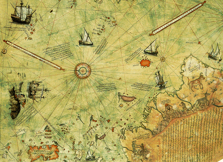
I just can't find it. I'm looking on the same latitude as Portugal... is it just to the left of the ship, and just to the right of the (forgive my ignorance of what this is actually called) two longish lines that resemble some sort of level? Or perhaps is it the large rectangular island outlined in reddish-orange off the coast of Central America? I read that the mythical Antillia was usually said to be located 200 miles west of the Azores, which would put it in the middle of the Atlantic, right? I am clueless... apparently Piri Reis drew Antillia, yet I can't see it. Thank you in advance for enlightening me. Adrienne ( talk) 02:33, 4 November 2008 (UTC)
- It's the large rectangular island in reddish orange.
Graeme Bartlett (
talk) 21:27, 4 November 2008 (UTC)
- Thanks... do others agree with this statement - that Piri Reis drew a mythical island in the Caribbean Sea? I can't imagine why anyone would risk their reputation by purposefully lying, but some people are stupid. I would not go so far as that, though; I wouldn't say that Piri Reis was a liar. How do we know for sure that the island he charted (or drew) isn't a representation of a real island? Is the language on the map written in Arabic... I can't tell, because the letters are so tiny. I wish we had a translated map, so all of us could see for ourselves what he wrote. If it says Antillia and he meant "the mythical island", that is one thing, but even if it says Antillia, perhaps it still represents an actual location given that name by himself. Albeit, a strangely portrayed and basically inaccurate location... :o) P.S. I realize that I am not technically using this Talk page properly, but I would like to improve the article, and if that means removing information that I consider questionable, then I suppose these comments of mine should go on this page. I won't remove the bit of information that states he drew a mythical island, but perhaps we should think about the repercussions of making that type of a statement. Adrienne( talk) 19:06, 6 November 2008 (UTC)
- I don't know what you mean by 'this page', but if you mean the article, no, your comments should not go there as Wikipedia is an encyclopedia reporting what verifiable and reliable sources say about a subject, see WP:RS. Meanwhile, see [1]. Note that he and the Egerton map use the word Antilia to refer to the New World continental mainland (on the portion of his map copied from a non-Columbian post-1504 map) as well as the legendary island. McIntosh suggests this may be because he used both 15th c. portolan charts showing an island of Antilia in the Atlantic and early 16th c. maps which name the western continent Antilia. By the way, it isn't located in the Caribbean Sea but in the Atlantic. What he wrote is "And this island they call the Island of Antilia. There are many monsters and parrots and much logwood. It is not inhabited." dougweller ( talk) 19:43, 6 November 2008 (UTC)
What part is supposed to be Antarctica?
I can't tell what part is supposedly Antarctica. What part is the southern landmass? It is all connected together.-- 72.39.35.178 ( talk) 04:29, 3 December 2008 (UTC)
- The bottom part has been claimed to be Antarctica - it is South America however. dougweller ( talk) 06:50, 3 December 2008 (UTC)
Planned article layout
I'm thinking of reorganizing this article into the following sections: Lead, "Map" - general map information, "Sources", "History", then a section on each area depicted in the map (Europe, Africa, South America, North America, Central America, Hispaniola and the Bahamas, and Antarctica) and then scholarly analysis from Hapgood, von Däniken, McIntosh and Menzies (more or less, if necessary). I might keep the scholarly analysis in one section, or split them into subsections for each scholar. Nishkid64 ( Make articles, not wikidrama) 23:03, 1 January 2009 (UTC)
- There's nothing scholarly about Hapgood, von Daniken and the others. Be careful of your sources.
PiCo (
talk) 10:15, 4 January 2009 (UTC)
- You may have problems unless you pay carefull attention to
WP:NPOV and
WP:UNDUE. Menzies might be worth a sentence, ditto con Daniken, Hapgood a few sentences, McIntosh a few paragraphs (and there are other scholars as well, Soucek comes to mind if I'm spelling that right). I don't see the point of separate sections on each area, especially in light of the confusion in the map itself (and Hapgood isn't enough to claim that Antarctica is there, I'd object to a section on it).
dougweller (
talk) 10:50, 4 January 2009 (UTC)
- Okay, thanks for the suggestions. PiCo, Hapgood sans the crazy claims is a good source for the Piri Reis map. von Daniken, of course, is a whole different story, and I only intend to bring him up to discuss the point regarding Antarctica. I haven't read Menzies so I can't comment on that. Regarding Antarctica, I think it's something that could be placed into a section, since it has attracted significant attention within the limited scope of Piri Reis map research. Of course, I won't emphasize the point too strongly, since it is disputed by almost all scholars. Nishkid64 ( Make articles, not wikidrama) 04:06, 5 January 2009 (UTC)
- You may have problems unless you pay carefull attention to
WP:NPOV and
WP:UNDUE. Menzies might be worth a sentence, ditto con Daniken, Hapgood a few sentences, McIntosh a few paragraphs (and there are other scholars as well, Soucek comes to mind if I'm spelling that right). I don't see the point of separate sections on each area, especially in light of the confusion in the map itself (and Hapgood isn't enough to claim that Antarctica is there, I'd object to a section on it).
dougweller (
talk) 10:50, 4 January 2009 (UTC)
South America, not Antarctica
I think the southermost parts of the map shows the southern west coast of South America. The differences between the map and the real world my be due to navigation errors or copying errors or both. Some sugestions on which places on the map corresponds to which real places is found here:
http://www.uwgb.edu/dutchs/PSEUDOSC/PiriRies.HTM
This web page also debunks the claim of the map showing Antartica.
2009-02-18 Lena Synnerholm, Märsta, Sweden. —Preceding unsigned comment added by 212.247.167.70 ( talk) 18:44, 18 February 2009 (UTC)
Criticisms of Antartica claim
An anonymous editor ( 24.168.5.223), added an entire paragraph of criticism, without citing a single source. I have reduced its absolute tone to one of conjecture, and left questions inline which should be answered in order for the paragraph to remain at all, specifically,
Lastly, the claim that the map depicts a portion of the ancient Antarctican landmass has certain criticisms <!--by whom?-->. Firstly, the map is large-scale and low-detail, and the landmass pictured is arguably not accurate enough to be matched to any actual landscape. Secondly, any similarity it may have to modern radar imaging of the Antarctica under the ice may be irrelevant, since in the period when Antartica was not covered with an ice cap its shorelines may be so different as to be completely unrecognizable, due to the pre-icecap sea level being significantly higher, and thus obscuring a great portion of the sixth continent. <!--where is this hypothetical shoreline image?-->
It is an interesting criticism, but more than borders on original research without citations. Invitation to comment left on 24.168.5.223talk page. -SM 07:40, 2 December 2005 (UTC)
I think the language in this part could be changed: "...a southern landmass that some controversially claim is evidence..." doesn't feel very NPOV. Kesshaka 00:39, 13 September 2007 (UTC)
- Why? It's a patently ridiculous claim on its face, and deserves to be taken far less seriously here than it already is. As is usual when you pit pseudoscience against science. TCC (talk) (contribs) 22:29, 13 September 2007 (UTC)
I've just removed a sentence stating that the "problems" of the depiction of South America / Antarctica were "explored in detail by Charles Hapgood". I had been tempted to replace "explored" by "created", since he originated the "ice-free" Antarctic theory- but instead I've just rearranged some of the material that offers alternative explanations for the features as depicted. David Trochos ( talk) 07:59, 28 February 2008 (UTC)
There is no mention of the identities of the purported scholars who question the validity of the Antarctic landmass' location on the Piri Reis map, which just happens to exist, in reality. There is landmass-attenuated radar that confirms that underneath the inconveniently accumulated sheets of ice is solid land. These scholars who criticize the map must be identified, so those who are following the grant-money and the revisionist "pseudo-scholarship" that it buys can be brought out into the scrutinizing public eye. Reasonsjester ( talk) 03:27, 13 April 2009 (UTC)
Greg McIntosh?
Who is Greg McIntosh? A scholar, or just some guy off the street? Whoever wrote the section referring to him needs to give it more context. -- Varenius 23:09, 12 April 2006 (UTC)
I see that Gregory McIntosh is now making some changes himself. I feel underqualified now ... He is the author of a book on the map that seems to represent the current scholarly consensus Simonkinahan 18:19, 26 June 2006 (UTC)
The Piri Reis Map was compiled from older source maps brought to Constantinople during the fourth crusade. When the city fell to the Ottomans the information stayed there. The origional material that the source maps were drawn from were most likely from Antartica. (Madmonkey1 is going to make some changes to this article) —Preceding unsigned comment added by Madmonkey1 ( talk • contribs) 01:11, 17 June 2009 (UTC)
Is this text of any value?
I've snipped the following from the article. It's deeply POV, assuming that the map does show Antarctica when this is hotly disputed. The first paragraph asserts that the De Virga world map shows the Americas, which it does not (see Wikipedia article - possibly it shows Newfoundland or Nova Scotia, but that's all). The second paragraph is a history of Antarctic exploration, which is covered in History of Antarctica. The final paragraph states that the map shows the West coast of the Americas, which it does not, and that the map of N America and the Carribean is accurate, which it obviously is not. There's also a bunch of stuff about other maps which is irrelevant here.
- I've taken the liberty of snipping it here as well, it's a load of fringey pseudoscience that doesn't need to be repeated here. Auntie E ( talk) 01:26, 20 June 2009 (UTC)
Air Force quote
Removed the following quote as unsourced:
- On 6th July 1960 the U. S. Air Force responded to Prof. Charles H. Hapgood of Keene College, specifically to his request for an evaluation of the ancient Piri Reis Map:
| “ | 6, July, 1960 Subject: Admiral Piri Reis Map |
” |
Seems a source is needed and some info re: Ohlmeyer's credentials and notability, as being a light bird carries no scientific weight to my knowledge. Vsmith ( talk) 16:36, 14 February 2009 (UTC)
- Good luck. No one has ever been able to trace Ohlmeyer so far as I know.
He is deceased. Here is his obituary: OHLMEYER, HAROLD Z Colonel, Retired USAF October 1, 1919 – September 22, 2010 Harold Z. Ohlmeyer, 90, passed away on September 22, 2010. Harold was born to Charles and Elma Ohlmeyer on October 1, 1919 in Franklin, LA. Harold married Sylvia Irene Matthews of Eden, Mississippi on December 29, 1944. They had three children: Beverly, Bill, and Ronald. Harold attended college at Saint Mary’s University in San Antonio, Texas where he played football, tennis, and was the three state light heavy weight boxing champion for two years. After the United States was attacked at Pearl Harbor Harold entered active duty in the Army Air Corps in January 1942 and was commissioned a 2nd Lieutenant. He was sent to Midland, Texas where he trained as a bombardier and remained as a ground school instructor at this station until August 1943. From December 1943 until December 1944 he served in North Africa and Italy as a bombardier in B-24 aircraft participating in 51 combat missions. On July 15, 1944 (455th BG mission #78) a mission was flown to attack the German oil production facilities at Dacio Romano Oil refinery at Ploesti, Rumania. Captain Ohlmeyer was the Bombardier of the lead aircraft. The Group bombed by “Pathfinder” equipment, due to a heavy concentration of smoke pots that had been installed in the area as part of the defense. Only select crews and Bombardiers were qualified in the Pathfinder system of Bombing. The 455th Group was to lead a maximum effort by the Wing of 165 B-17s and 542 B-24s. The fighter escort was comprised of 231 P- 51s and 153 P-38s. A total of 155 B-24s were to strike the specific target of Dacio Romano Oil Refinery. All aircraft were led to the target by the lead aircraft and released on Captain Ohlmeyer’s position marking. The target was destroyed. As the squadron Bombardier, he achieved one of the highest bomb scoring percentages in the United States Air Force. After returning from the war Colonel Ohlmeyer completed many assignments around the world retiring on August 26, 1968. Colonel Ohlmeyer’s final assignment was as Special Assistant to the Director for Satellite Programs of the Space and Missile Systems Organization. Colonel Ohlmeyer received the following awards and decorations: Legion of Merit, Distinguished Flying Cross with Oak Leaf Cluster, Air Medal with Four Oak Leaf Clusters, Air Force Commendation Medal, Presidential Unit Citation with Oak Leaf Cluster, Air Force Outstanding Unit Award, American Campaign Medal, European-African- Middle Eastern Campaign Medal, WWII Victory Medal, National Defense Service Medal with Oak Leaf Cluster, Air Force Longevity Medal with Silver Oak Leaf Cluster. His Military Flight Ratings were Command Navigator Badge and Master Missileman Badge. Upon retirement Colonel Ohlmeyer, his wife Irene, and son Ronald moved to Yazoo City, Mississippi. While in Yazoo City he was headmaster at Manchester Academy, and then headmaster at Cruger-Tchula Academy. Later he worked for the State in the Mental Health program running the county office in Yazoo City and then the district office in Vicksburg. He loved to play golf at the Yazoo City Country Club and fish in a “Secret” place. Colonel Ohlmeyer and Ronald attended a military reunion for one of the organizations that he commanded and a golf tournament was initiated in his honor as an annual event. He is preceded in death by wife Sylvia Irene and six brothers/sisters. He is survived by daughter Beverly Lavin and husband Paul, son Bill and wife Kathy, and son Ronald and wife Paula; grandchildren Scott and wife Chris, Jennifer and husband Paul, Bill Jr., Christopher and wife Erika, Steven and wife Katie; great grandchildren Sasha, Ava, Rachel, Grace, Austin, Tyler, Jenna, Evelyne, and Gabriella. He is also survived by brother Charles, sister Joyce Stubban, and numerous nieces and nephews. Visitation is on Friday, September 24th, 5-7pm at Wright-Ferguson Funeral Home in Ridgeland, Mississippi. On Saturday, September 25, 11am – 1pm visitation will be at Stricklin-King Funeral Home in Yazoo City followed by a service, at 1pm at Stricklin-King Chapel inYazoo City, Mississippi. 2 Graveside Services with military honors, September 25th, following the Chapel service at Tranquil Cemetery, Free Run, Mississippi. In lieu of flowers donations can be made to Tranquil Cemetery, 273 Davey Drive, Benton MS 39039. The family would like to thank caregivers who helped provide loving care including St. Catherine’s, Campbell Cove staff, Sta-Home Health Services Canton Office, and Prime Care Nursing especially Kendal Ball, Linda Sallis and Shana Thompson.
The geologist Paul Heinrich wrote:
- However, Lt. Colonel Harold Z. Ohlmeyer, 8th Reconnaissance Technical Squadron and Dr. Hapgood all made significant errors that invalidate their conclusions. First, both Lt. Colonel Ohlmeyer and Dr. Hapgood incorrectly assume that the subglacial topography of Antarctica is the same as the ice-free topography of Antarctica. The actual subglacial topography differs from a hypothetical ice-free topography because of the 293,778,800 cubic kilometers of ice that either lies grounded on bedrock or stacked as ice rises on bedrock islands (Drewry 1982, sheet 4). The sheer weight of this ice has depressed the continent of Antarctica and associated crust by hundreds of meters. Should the weight of the Antarctic ice be removed form the Antarctic crust, isostatic rebound would raise the subglacial topography as much as 950 meters (3100 feet) in the interior to 50 meters (160 feet) along the coast. Furthermore, melting of all of the world's ice, of which Antarctic ice cap is 90 percent of the total, would raise sea level by about 80 meters (260 feet)(Drewry 1983, sheet 6). Thus, the modern subglacial bedrock topography and the modern coastline differs significantly from the coastline and topography of a hypothetical ice-free Antarctica. Thus, the topography and coastline that Lt. Colonel Ohlmeyer and Dr. Hapgood claim match the Piri Reis Map would be different from the topography and coastline that would characterize a hypothetical ice-free Antarctica.
- Second, the Piri Reis Map lacks any topographic contours. If contours are lacking on the Piri Reis Map, the topographic data needed to compare the topography shown by the 1949 seismic data with the topography of the Piri Reis Map on a scientific basis are completely lacking. Without this data, the claims of Lt. Colonel Ohlmeyer and Dr. Hapgood are nothing more personal opinions, certainly not proof, that cannot be scientifically tested.
- Finally, the single seismic line, i.e. the seismic profile of the Norwegian-British Swedish Expedition of 1949, is insufficient evidence to determine if the subglacial bedrock topography of Antarctica resembles the Piri Reis map. The problem is that the comparison is being made along one essentially randomly chosen line. Neither Lt. Colonel Ohlmeyer, Dr. Hapgood, nor the 8th Reconnaissance Technical Squadron could know whether the topography outside of this line, a good 99.9 percent of the area resembled the Piri Reis map because they lacked any other data in addition to the seismic profile. Even the map of the bedrock geology of Antarctica compiled in 1972, Heezen et al. (1972) shows that even by that date the bedrock topography lying beneath Queen Maud Land was largely unmapped and unknown. Thus, even in 1961, because of insufficient information, it would have been impossible for anybody to make any positive claims about whether the Piri Reis Map and the subglacial topography shows any resemblance.
- Since 1949 and 1966, Drewry (1982) compiled the available data obtained from seismic surveys and radio echo soundings into what still considered the most comprehensive mapping that has ever been published. A comparison of the portion of the Piri Reis map, which they claim to be Antarctica, with a both more recent subglacial bedrock topography map (Drewry 1982, sheet 3) and a bedrock surface map isostatically adjusted for glacial rebound (Drewry 1982, sheet 6) showed a distinct lack of any striking similarities their coastlines and that of the Piri Reis Map. The lack of correspondence between the Piri Reis Map and an ice-free Antarctica is not surprising given the evidence presented by Linde (1980) that the source maps for the other parts of the Piri Reis Map are of no great antiquity.
- Drewry, D. J. (ed.), 1983, Antarctica: Glaciological and Geophysical Folio. Scott Polar Research Institute,Cambridge. dougweller ( talk) 17:11, 14 February 2009 (UTC)
- --My Grandfather's credentials are above reproach. Take the letter for exactly what it says. Do not try to read fantastic meaning into the letter as none was intended. W.ohlmeyer ( talk) 06:24, 4 September 2009 (UTC)
Why is Erich von Daniken's opinion included?
As far as i know he has no expertise in the matter. His value on this subject is equal to one given by any stranger on the street. He is pseudo scientist who regularly makes extraordinary claims to explain the slightest mystery. —Preceding unsigned comment added by 115.132.59.120 ( talk) 00:59, 4 January 2010 (UTC)
- Good point. I removed the section.
Auntie E. 01:02, 4 January 2010 (UTC) oops, sorry, guess I didn't...
Auntie E. 03:26, 4 January 2010 (UTC)
- People paid a lot of attention to him before, but if no secondary sources repeat EVD opinion, then it should stay out, otherwise it could go back. Graeme Bartlett ( talk) 10:18, 5 May 2010 (UTC)
the lead and categories
I recently deleted a section of the lead and a couple of categories. This has been reverted with the summary "Rv major changes without consensus". I don't consider what I did to be "major changes", but I'll explain anyway. The map is genuine, from 1513, and historically important because it contains material unprecedented at that date. Many scholars have studied it and written about it. A few of those scholars have put forward theories with which other scholars disagree. This status in no way makes it an "Out-of-place artifact". Similarly, the fact that some writers have put forward minority opinions does not justify labelling the whole article with "Category: Pseudo-scholarship" (unless that's meant to be an insult to the article itself, which would be a little unfair). Anyone reading the article presumably wants to know what the map is. It is confusing and unhelpful if the lead immediately starts telling us what the map is not. The impression is thereby given that the map's main importance is in the theories about "extra-terrestrials or an Ice Age civilization", which is a deeply silly thought. The imporession is also given that the writers of the article are more concerned to control our opinions than to inform us, which is not what wikipedia should be doing. SamuelTheGhost ( talk) 11:20, 4 May 2010 (UTC)
- I've removed Oopart, but I'm still wondering. The problem is, Oopart sites/fringe sites often call it an Oopart. Although the article needs to include the fringe stuff, it does need to be basically a scholarly article. I suggest that the first paragraph not mention anything about the fringe stuff, but that a 2nd paragraph in the lead say something about it. I don't think there's a serious case of disagreement among scholars here if that is what you are suggesting. Dougweller ( talk) 12:34, 4 May 2010 (UTC)
- "Oopart sites/fringe sites often call it an Oopart" - your point being?
- "it does need to be basically a scholarly article" - just like every other wikipedia article.
- I find the concept "fringe", as used by wikipedia editors, to be confused and unhelpful. In this case there needs to be a clear distinction between:
- minority but sane ideas, such as that there may have been transatlantic exploration before 1492. Such ideas could be mentioned in a second paragraph of the lead, as you suggest;
- nonsense like "extra-terrestrials", currently and ridiculously given in the lead and nowhere else. That should only be mentioned where clearly notable, and certainly not in the lead. SamuelTheGhost ( talk) 14:52, 4 May 2010 (UTC)
- We do not expect all our articles to be scholarly, unless you have a very different definition of scholarly than I have. We have huge numbers of articles on music, villages, cities, towns, books, tv programs, cartoons, etc. that we don't expect to be scholarly. They are almost certainly the vast majority of articles. If aliens aren't in the article, they shouldn't be in the lead. If you find 'fringe' unhelpful then please discuss that at the appropriate venues, it's part of our guidelines. Dougweller ( talk) 16:12, 4 May 2010 (UTC)
- When I removed aliens last Friday, another editor put them back. Will you support my removing them again, or will you do it?
SamuelTheGhost (
talk) 16:30, 4 May 2010 (UTC)
- Thank you. SamuelTheGhost ( talk) 10:59, 5 May 2010 (UTC)
- When I removed aliens last Friday, another editor put them back. Will you support my removing them again, or will you do it?
SamuelTheGhost (
talk) 16:30, 4 May 2010 (UTC)
I must agree. This is a serious article which simply had certain fringe / pseudoscholarly items blown out of proportion. The solution is to cut these back within WP:DUE, not to tag the entire article as "pseudoscholarship". WP:FRINGE applies. -- dab (𒁳) 16:56, 12 May 2010 (UTC)
Moved from article as it should be here
An editor worries that this section of the article is too favourable towards Gavin Menzies's theories. I came to the article after just now reading "1421: The year China discovered the world" - this is a fqascinating book but with many dubious claims. In my opinion the treatment in this article does not go very far along Menzies's "route" and is well balanced. Eric Deeson 28 Apr 2011 —Preceding unsigned comment moved here from article by Dougweller ( talk • contribs) 09:08, 28 April 2011 (UTC)
Section on Antarctica Changes
I made a minor change in the Antartica section. As it was before:
For centuries before the actual discovery of Antarctica cartographers had been depicting a massive southern landmass on global maps based on the theoretical assumption by Europeans that one must exist, if only to balance the landmass of the North, as God was at the time widely believed to be the creator, and being believed to favour symmetry.
As you can see on the current version, I removed the last two sentence segments. I did so for 2 reasons.
First, because "as God was at the time widely believed to be the creator" is not a neutral statement, as it suggests the belief is out-of date and false. It is also untrue, because of the fact that people still "widely believe" that God created the world (of course the term "widely" is an indefinite one, but I think it's fair to say that a large portion of the world believes this)
- (above) I'm sorry this is not a neutral statment. If this is Wikipedia then he is obliged to say "as God was at the time widely believed to be the creator" and your statement that is incorrect is a secular argument and not be should not be given voice on here. God is out-of-date and false as an answer to science, especially when invalidating a pseudoscientic argument in the first place; further, scientists may be Christian or Muslim or whatever, but they are not entitled to have their beliefs documented on a site that's specifically designed for anybody to be able to seek answers and find them without finding god has anything to do with it. ***
Secondly, I am also fairly confident that the belief in the symmetry of the world's design, as Ptolemy was at least one of the early thinkers who suggested this.
While this is obviously a very long explanation for the trimming of one sentence, I believe it's important to note why the change was done, rather than noticing a mysterious change in the entry's history.-- C.Logan 02:33, 28 August 2006 (UTC)
- Your sentence seems to need fixing as well. Check it out:
- Secondly, I am also fairly confident that the belief in the symmetry of the world's design, (???) as Ptolemy was at least one of the early thinkers who suggested this.
- Should it read "Secondly, I am also fairly confident in the belief in the symmetry of the world's design..." or were you planning on writing something before mentioning Ptolemy?
- 202.128.36.37 08:32, 25 January 2007 (UTC)
In response to one of the above posts criticizing the Antarctic Claim, if the map was written before the coast of antarctica was covered in ice, then one would also conclude that the poles had shifted as they do from time to time, and drastically changed the geography of many parts of the world, explaining many of the differences in modern day maps and ancient ones.
If you look back over history you see that there were once tropical animals living in Alaska, and New Zealand was once nearly lifeless. This would suggest that New Zealand was once under one of the poles, and Alaska was farther from it.
It does not take much of a stretch of the imagination if one knows the history of the world, to come to the conclusion that the poles shift from time to time. People could have had a fairly advanced civilization, probably mostly seafaring, that got wiped out when the poles shifted, or sometime afterwards. The continents have been breaking apart for a while, and the Americas and Eurasia/Africa are still spreading apart. It does not take that much imagination to look at a map and assume that the Americas, Antarctica, and Africa were once connected. They are slowely being torn asunder by weight (ice, water, other) accumulating in certain places of the earth. At some point this builds up to a tipping point, where the Earth shifts on its axis. How this happens, weather it be by the crust displacment theory that Einstein advocated, or other means is not at issue. What is at issue is some of the people who have written in this article are deliberatley obscuring the facts about this piece of evidence because it disagrees with the status quo and conventional wisdom. Maybe they think that God created the world 5,000 years ago, or maybe they have a job in Archeology and can't admit they don't know everything, but they should stop libeling this evidence of an ancient civilization that mapped the coast of Antarctica, (and the Americas,) before it was even known to Western Civilization.
I am going to recheck my sources, and then cut up this article in parts that resemble an ad hominem attack on this important piece of historical evidence. Sincerely, Madmonkey1 —Preceding unsigned comment added by Madmonkey1 ( talk • contribs) 01:59, 17 June 2009 (UTC)
They didn't map Antarctica. I mean, if it were meant to be Antarctica, then why on earth would it connect to South America? There's also the small matter that it looks like South America quite a lot, and doesn't look like Antarctica even a little bit. This is a bit like seeing a turkey strutting about at a farm, and then trying to convince everyone you know that it wasn't a turkey, that it was in fact an Allosaurus, and then getting rather irate when people would point out that it has feathers and a beak, and isn't in fact 30 feet long, with long bitey teeth and big claws, and shouting like a madman that they think they know everything, and that they shouldn't be denying this proud hunter.
I think I've gone off track a bit. Anyway, it's a turkey, not an allosaur. —Preceding unsigned comment added by 174.54.221.188 ( talk) 17:06, 15 March 2010 (UTC)
Madmonkey - you're right that this is an important piece of historical evidence. It may, for example, be the best surviving evidence for Columbus maps of the Caribean. However, Charles Hapgood's specific claims about Antarctica are not credible. See the section at the bottom and look at the thing yourself - the coastline looks like South America, not Antarctica. If you want to write about Hapgood's theories, the right place to do it is on his page. Dedication too much space to non-mainstream scholarship is not NPOV. —Preceding unsigned comment added by Simonkinahan ( talk • contribs) 03:59, 17 June 2009 (UTC)
I hope my formatting and location here (as opposed to starting a new topic) is correct. I am making a citation request for the following: "For centuries before the actual discovery of Antarctica, cartographers had been depicting a massive southern landmass on global maps based on the theoretical assumption by some that one must exist, if only to balance the landmass of the North." What evidence do we have that their reasoning is based on a theoretical assumption? When did who say this, and can we get a link to support this claim? 98.125.71.131 ( talk) 17:27, 9 October 2011 (UTC)
Biblical Connection
A compilation by Roy Schulz 'Exploring Ancient History - The First 2500 Years' indirectly explains the source of the Piri Reis map. Roy did not mention the Piri Reis map by name but did acknowledge the source for the ancient maps that depicts continents and places far away when they were not suppose to have been discovered until in later times. Roy stated that God gave Noah the maps of the world to carry out the mission of warning the world in pre-flood societies of the impending destruction and to re-colonise the world after the flood. This makes a lot of sense if you believe in the Bible and that there is a God with a purpose for creating man but will prove otherwise if you believe in alternative(s). —Preceding unsigned comment added by Peterjacob ( talk • contribs) 11:36, 1 May 2008 (UTC)
- One thing I love about Wikipedia is the ideas that come up. But for this one ... well, the Genesis story of the Flood says nothing about Noah warning the world of what was about to happen. Nor would it make sense for him to do so, since God's aim was to destroy the world, not save it. As for re-colonising after the flood, Genesis only mentions the settlement of lands around the eastern Mediterranean, not the whole world. I do wish people would read these things - we really do need some decent bible-study classes in our schools. PiCo ( talk) 02:50, 5 January 2009 (UTC)
Never read Roy's thing, so I have no idea what how he supports that statement, but the bible neither indicates nor disallows it, on its own, but there certainly is a lot of speculation about the documents and things Noah might have preserved. I do personally doubt that God made maps for Noah (and I don't think much skill is involved in piloting a box), but there's no reason he could not have acquired them on his own. You would need to back up such a claim, though. There is a mention of world-wide migration however, although I'm sure it's possible to contest it's meaning. Genesis 11:8: "Accordingly Jehovah scattered them from there over all the surface all the earth..." (NWT) Also, Genesis 9: 19 - "These three were Noah's sons, and from these was all the earth's population spread abroad." Make whatever you like out of it. SuperMudz ( talk) 05:02, 4 July 2012 (UTC)
- I'm not sure that Roger's book qualifies as a reliable source according to wikipedia standards. I couldn't find any review of the book that allowed us to see its influence in scholarship. It's Roger's only book, so we can't assess the reception given to his other works. The publisher is a department of "Imperial Schools" in Pasadena, which appear to a defunct high school that was located in the campus of Ambassador College. There is a copy in the Internet by the author [2] and it seems to be self-published via xerox. The first three paragraphs indicate that this book would need a lot more work before being accepted at a scholar publisher. It also had very limited distribution: from the fourth paragraph "Only seven copies of this incomplete version are being Xeroxed at this time for limited library use.". It also seems an attempt to create a new paradigm in history, re-explaining everything from the point of view that the Bible is accurate, so WP:FRINGE would apply: "(...) a general, overall concept as to what was really taking place in the centuries before and after the flood. Certainly a more accurate concept than modern-day histories provide. (...) Dr. Hoeh has stated, "the time is coming when all history books will be rewritten."". Finally, I don't see any scholar credentials for the author that can help establish reliability. -- Enric Naval ( talk) 10:59, 4 July 2012 (UTC)
It's obviously Antarctica
Use common sense. How can the entire map be so accurate except for the one part? Common sense tells anyone with a brain that it's Antarctica. I am very sorry if that doesn't fit into someone's box. I just find it very difficult to believe that someone would go through all of the trouble to compile all these maps together, and create such a masterpiece of cartography, and then blow the whole bottom edge of the map. I don't buy it. I'm sorry if it has to rewrite some historical footnote somewhere, but it's obviously Antarctica. — Preceding unsigned comment added by 209.193.21.1 ( talk) 05:55, 10 July 2012 (UTC)
- Get something published in a reliable source and maybe it can be included, but our articles are built upon what 'reliable sources'(by our definition) and not what someone calls 'common sense' (my common sense tells me that it is extremely unlikely anyone visited Antarctica at that time). Dougweller ( talk) 08:31, 10 July 2012 (UTC)
- While it is a very good map, it is far from being the "masterpiece of cartography" as claimed. Moreover, the bottom part is quite clearly the rest of South America bent over, just as seems to be the case with Central America. And as mentioned by Doug, your "common sense" is far from being a reliable source. I believe that using common sense it is quite obvious that this is not antarctica.-- 187.65.128.85 ( talk) 18:24, 7 January 2013 (UTC)
Excuse I don't understand how you write this article, and I don't actually care how you do it. What concerns me is the nonsense result that is coming out. Why there is a separate section Antarctica? I have read about the Piri Reis map here, hoping to understand its significance and what I understand from the mess you produce, is that it has 0 significance in cartography!!! Only after reading in other sources I can see that, it possibly shows the land borders of Antarctica with some accuracy, which was not known in 1510. But it is not mentioned here at all! Nothing is mentioned here! So why did you out a separate section as "Antarctica". If you don't see the point. Read the whole story as if you don't know the subject at all and you will see the article doesn't say anything. What I understand from wikipedia article is that the Turkish Government should throw the map in the dustbin because it has no cartographic significance at all. It's Turkish made anyway, not Greek. The entry must mention why it's a significant map, or must mention some believe so... I hope you pay attention to that. — Preceding unsigned comment added by 95.8.129.185 ( talk) 17:41, 24 January 2013 (UTC)
Confused
I am confused. The lead talks about "the half of the map that survives" showing the western coasts of Europe and North Africa, and parts of the New World, with accompanying graphic matching that description.
Yet later in the article there is another "part" depicted, which shows almost the whole of Europe, as well as parts of North Africa and and eastern Asia:

The text does not seem to acknowledge the existence of this other part, which doesn't seem to be drawn in quite the same style, and is not even obviously part of the same map. 86.179.2.60 ( talk) 14:04, 11 July 2012 (UTC)
- Actually only about 1/3rd of the map survives - the western portion. So we have western Europe, the bulge of W. Africa, various islands, and on the left South America, Lesser Antilles, Puerto Rico and "what appears to be a confused depiction of Hispaniola, Cuba, the Bahamas and Central America."(McIntosh). The top picture is the left part of the map, the picture further down is the left part. But it would help if we had an image of the entire portion of what is left. Dougweller ( talk) 17:06, 11 July 2012 (UTC)

added to article. Dougweller ( talk) 17:09, 11 July 2012 (UTC)
- Now I am even more confused. We now seem to have two identical fragments, one labelled as "left fragment" and the other "the entire remaining map", and still no explanation of the connection with the different-looking map that I posted above.
86.179.2.60 (
talk) 19:05, 11 July 2012 (UTC)
- Could it be that the map labelled "Part of the Piri Reis map showing Europe and the Mediterranean Basin" is a reconstruction or later copy of a part that hasn't survived?
86.179.2.60 (
talk) 19:10, 11 July 2012 (UTC)
- I am also confused. This article is about Piri Reis' map of America. Maybe the map of Europe is a different map that was also among Piri Reis papers? --
Enric Naval (
talk) 11:18, 1 August 2012 (UTC)
- No, the article is about his world map. The problem is that although the image shows all of what is left of the map, it used the phrase "left fragment" rather than "surviving fragment". I've fixed that,ok?
Dougweller (
talk) 15:03, 1 August 2012 (UTC)
- Then the lead is mistaken, it says: "The approximately one-third of the map that survives shows the western coasts of Europe and North Africa and the coast of Brazil with reasonable accuracy". Either more map survived, or the Europe map is a reconstruction. -- Enric Naval ( talk) 15:17, 1 August 2012 (UTC)
- P.D.: the lead is probably correct. The Europe map must be a different map, also authored by Piri Reis.-- Enric Naval ( talk) 15:28, 1 August 2012 (UTC)
- No, the article is about his world map. The problem is that although the image shows all of what is left of the map, it used the phrase "left fragment" rather than "surviving fragment". I've fixed that,ok?
Dougweller (
talk) 15:03, 1 August 2012 (UTC)
- I am also confused. This article is about Piri Reis' map of America. Maybe the map of Europe is a different map that was also among Piri Reis papers? --
Enric Naval (
talk) 11:18, 1 August 2012 (UTC)
- Could it be that the map labelled "Part of the Piri Reis map showing Europe and the Mediterranean Basin" is a reconstruction or later copy of a part that hasn't survived?
86.179.2.60 (
talk) 19:10, 11 July 2012 (UTC)
- Yes, I've removed that map as it doesn't belong here and just confuses people.
Dougweller (
talk) 16:13, 1 August 2012 (UTC)
- Originally the caption said surviving, but an IP saw the map I removed, decided it was the right side of the map and changed the caption. [3], Dougweller ( talk) 16:18, 1 August 2012 (UTC)
- Yes, I've removed that map as it doesn't belong here and just confuses people.
Dougweller (
talk) 16:13, 1 August 2012 (UTC)
I have just removed that map again. Seriously, why would anyone re-insert it after the above discussion? -- dab (𒁳) 17:27, 7 July 2014 (UTC)
Antarctica on 1562 map?
Looks like Antarctica on this 1562 map and it's not covered by ice because of the rivers. Found on Age of Exploration Wiki page:
http://upload.wikimedia.org/wikipedia/commons/thumb/e/e9/Guti%C3%A9rrez%2C_the_Americas%2C_1562.jpg/1024px-Guti%C3%A9rrez%2C_the_Americas%2C_1562.jpg — Preceding unsigned comment added by 50.100.58.228 ( talk) 14:13, 29 April 2015 (UTC)
- As this page is not a forum for general discussion, your question really doesn't belong here. However, I'll answer it. If you zoom in at [4] you will see that the land just south of the tip of South America is labelled clearly "Tierra de Magallanes", in English the Strait of Magellan, navigated by Magellan in 1520, four decades before this 1562 map. Dougweller ( talk) 16:01, 29 April 2015 (UTC)
External links modified
Hello fellow Wikipedians,
I have just modified 4 external links on Piri Reis map. Please take a moment to review my edit. If you have any questions, or need the bot to ignore the links, or the page altogether, please visit this simple FaQ for additional information. I made the following changes:
- Added archive https://www.webcitation.org/5hFIaQq0J?url=http://www.tcmb.gov.tr/yeni/eng/ to http://www.tcmb.gov.tr/yeni/eng/
- Added archive https://www.webcitation.org/5hFIaQq0J?url=http://www.tcmb.gov.tr/yeni/eng/ to http://www.tcmb.gov.tr/yeni/eng/
- Added archive https://web.archive.org/web/20090422212451/http://www.tcmb.gov.tr/yeni/mevzuat/EMISYON/KARARTEBLIGVEGENELGELER/duyuruytl-ing.htm to http://www.tcmb.gov.tr/yeni/mevzuat/EMISYON/KARARTEBLIGVEGENELGELER/duyuruytl-ing.htm
- Added archive https://web.archive.org/web/20060202101525/http://quest.arc.nasa.gov/antarctica/background/NSF/palmer.html to http://quest.arc.nasa.gov/antarctica/background/NSF/palmer.html
When you have finished reviewing my changes, you may follow the instructions on the template below to fix any issues with the URLs.
This message was posted before February 2018.
After February 2018, "External links modified" talk page sections are no longer generated or monitored by InternetArchiveBot. No special action is required regarding these talk page notices, other than
regular verification using the archive tool instructions below. Editors
have permission to delete these "External links modified" talk page sections if they want to de-clutter talk pages, but see the
RfC before doing mass systematic removals. This message is updated dynamically through the template {{
source check}} (last update: 18 January 2022).
- If you have discovered URLs which were erroneously considered dead by the bot, you can report them with this tool.
- If you found an error with any archives or the URLs themselves, you can fix them with this tool.
Cheers.— InternetArchiveBot ( Report bug) 11:40, 2 December 2017 (UTC)
External links modified
Hello fellow Wikipedians,
I have just modified 2 external links on Piri Reis map. Please take a moment to review my edit. If you have any questions, or need the bot to ignore the links, or the page altogether, please visit this simple FaQ for additional information. I made the following changes:
- Added archive https://web.archive.org/web/20090915214617/http://www.tcmb.gov.tr/yeni/banknote/E7/10m.htm to http://www.tcmb.gov.tr/yeni/banknote/E7/10m.htm
- Added archive https://web.archive.org/web/20090417003929/http://tcmb.gov.tr/yeni/banknote/E8/14.htm to http://www.tcmb.gov.tr/yeni/banknote/E8/14.htm
When you have finished reviewing my changes, you may follow the instructions on the template below to fix any issues with the URLs.
This message was posted before February 2018.
After February 2018, "External links modified" talk page sections are no longer generated or monitored by InternetArchiveBot. No special action is required regarding these talk page notices, other than
regular verification using the archive tool instructions below. Editors
have permission to delete these "External links modified" talk page sections if they want to de-clutter talk pages, but see the
RfC before doing mass systematic removals. This message is updated dynamically through the template {{
source check}} (last update: 18 January 2022).
- If you have discovered URLs which were erroneously considered dead by the bot, you can report them with this tool.
- If you found an error with any archives or the URLs themselves, you can fix them with this tool.
Cheers.— InternetArchiveBot ( Report bug) 10:33, 30 December 2017 (UTC)