 TIROS-2 before launch | |
| Mission type | Weather satellite |
|---|---|
| Operator | NASA [1] |
| Harvard designation | 1960 Pi 1 |
| COSPAR ID | 1960-016A |
| SATCAT no. | 63 |
| Mission duration | 376 days |
| Spacecraft properties | |
| Spacecraft type | TIROS |
| Manufacturer |
RCA Astro GSFC |
| Launch mass | 127 kilograms (280 lb) [2] |
| Start of mission | |
| Launch date | November 23, 1960, 11:13:03 UTC [3] |
| Rocket | Thor DM-19 Delta |
| Launch site | Cape Canaveral LC-17A |
| End of mission | |
| Last contact | December 4, 1961 |
| Decay date | May 2014 |
| Orbital parameters | |
| Reference system | Geocentric |
| Regime | Low Earth |
| Semi-major axis | 6,755.43 kilometers (4,197.63 mi) |
| Eccentricity | 0.0014596 |
| Perigee altitude | 374 kilometers (232 mi) |
| Apogee altitude | 394 kilometers (245 mi) |
| Inclination | 48.51 degrees |
| Period | 92.09 minutes |
| Epoch | December 8, 2013, 11:58:18 UTC [4] |
| Instruments | |
| Widefield Radiometer Scanning Radiometer Television Camera System | |
TIROS-2 (or TIROS-B) was a spin-stabilized meteorological satellite. It was the second in a series of Television Infrared Observation Satellites. It re-entered in May 2014. [5]
Spacecraft
TIROS-2 was an 18-sided right prism, 107 cm in diameter and 56 cm high, [2] with 9,260 [1] 1 by 2 cm silicon solar cells covered the top and sides. Five small directly opposed pairs of solid-fuel thrusters maintained a spin of 8 to 12 rpm. [2] For attitude control, the spacecraft used an infrared horizon sensor [1] and an magnetic attitude control device, made of 250 cores of wire wound around the outer surface, which oriented the spin axis to a 1 to 2 degree accuracy. [2] It also had a direction indicator for picture orientation. [1]
The satellite had two independent television camera subsystems, one low-resolution and one high-resolution, for taking pictures of cloud cover. Each camera had a magnetic tape recorder for storing photographs while out of range of the ground station network. [1] It also had a five-channel medium-resolution scanning radiometer and a two channel non-scanning low resolution radiometer for measuring radiation from the earth and atmosphere. [2]
Launch
TIROS-2 was launched on November 23, 1960 at 11:13:03 UTC, by a Thor-Delta rocket from Cape Canaveral, Florida. The spacecraft functioned nominally until January 22, 1962. The satellite orbited the Earth once every 98 minutes, at an inclination of 48.5°. Its perigee was 609 kilometers (329 nmi) and apogee was 742 kilometers (401 nmi).
The spacecraft functioned nominally until January 22, 1961.
Instruments
TIROS 2 added two infrared radiometers to TIROS 1 instruments, which allowed more analysis of frontal zones. [6]
Gallery
-
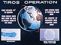 Graphic of TIROS-2 orbital path and examples of data products.
 -
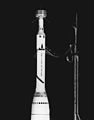 TIROS-2 satellite atop of a Delta rocket during a mock countdown on Pad 17A
 -
 TIROS-2 satellite atop of launch vehicle, under hangar roof
 -
 Launch of TIROS-2 on November 23, 1960
 -
Universal Newsreel about the launching of the TIROS-2 satellite
-
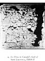 Ice floes as seen in Canada's Gulf of St. Lawrence by TIROS-2 on March 1961
 -
 Map of TIROS II infrared imagery with accompanying cloud analysis


References
- ^ a b c d e "TIROS". science.nasa.gov. NASA. Retrieved January 15, 2023.
- ^ a b c d e "TIROS 2". National Space Science Data Center. Retrieved January 15, 2023.
- ^ McDowell, Jonathan. "Launch Log". Jonathan's Space Page. Retrieved December 8, 2013.
- ^ "TIROS 2 Satellite details 1960-016A NORAD 63". N2YO. December 8, 2013. Retrieved December 8, 2013.
- ^ "TIROS 2". Archived from the original on December 22, 2014. Retrieved December 22, 2014.
- ^ Hawkins, R. S. (October 1, 1964). "Analysis and Interpretation of TIROS II Infrared Radiation Measurements". Journal of Applied Meteorology. 3 (5): 564–572. Bibcode: 1964JApMe...3..564H. doi: 10.1175/1520-0450(1964)003<0564:aaioti>2.0.co;2. hdl: 2027/mdp.39015095125376. ISSN 0021-8952.
TIROS satellites | ||
|---|---|---|
| TIROS |  | |
| TOS | ||
| ITOS | ||
| TIROS-N | ||
| Adv. TIROS-N | ||